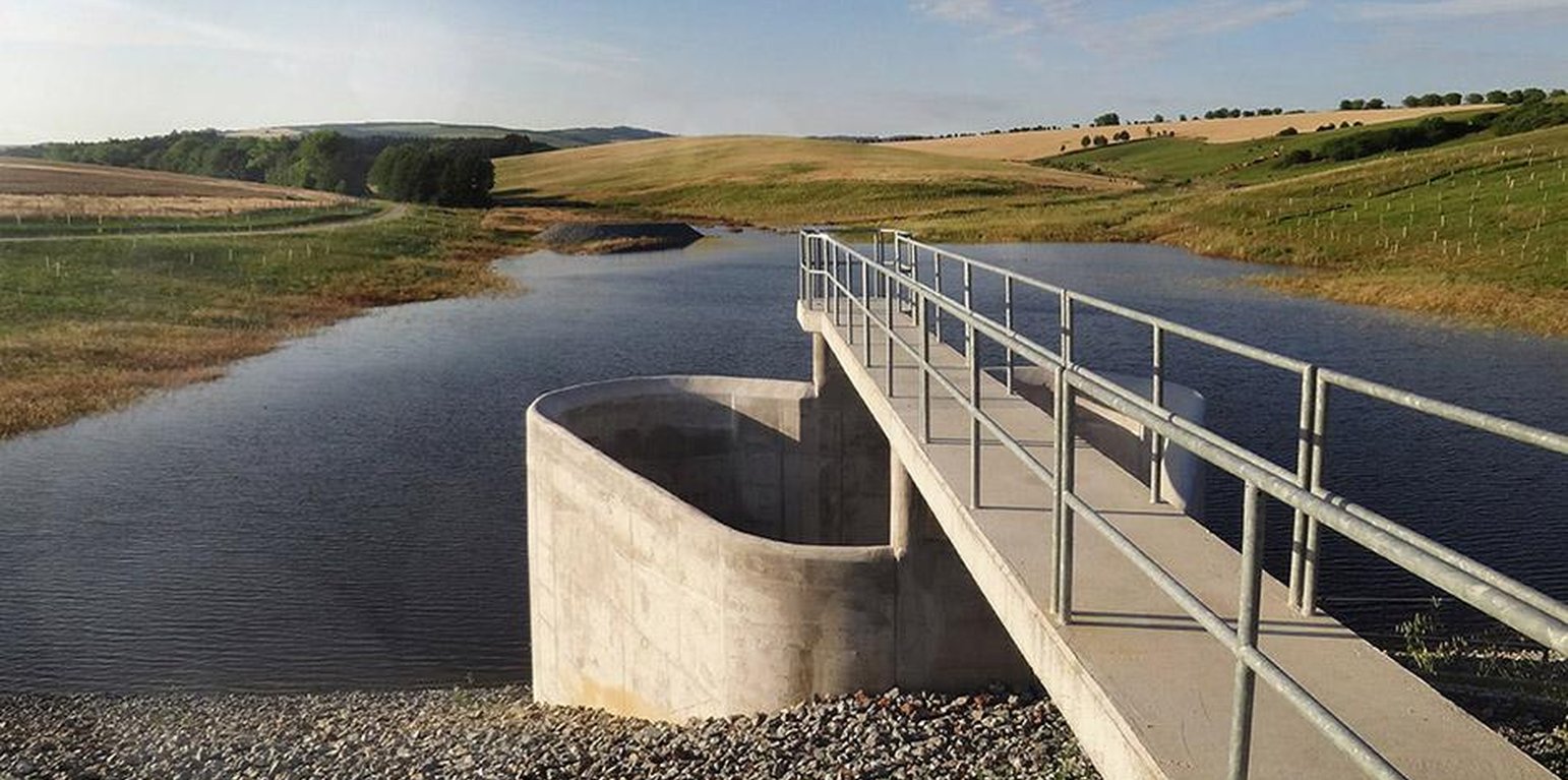
Flood-Control Reservoir ((http://vodotika.sk/projects/polder-svacenicky-jarok/))

Water retention basin, a flood-control reservoir (斯洛伐克)

Polder (Slovak language)

描述

Flood-Control Reservoir - a complex hydraulic facility

The construction is designed to prevent the flooding of the territory located behind the structure, to eliminate the threat of floods caused by storm rainfall and inappropriate farming, and to reduce flow fluctuation.

Purpose of the Technology: The Svacenický creek polder was built to transform Q100 flood waves.

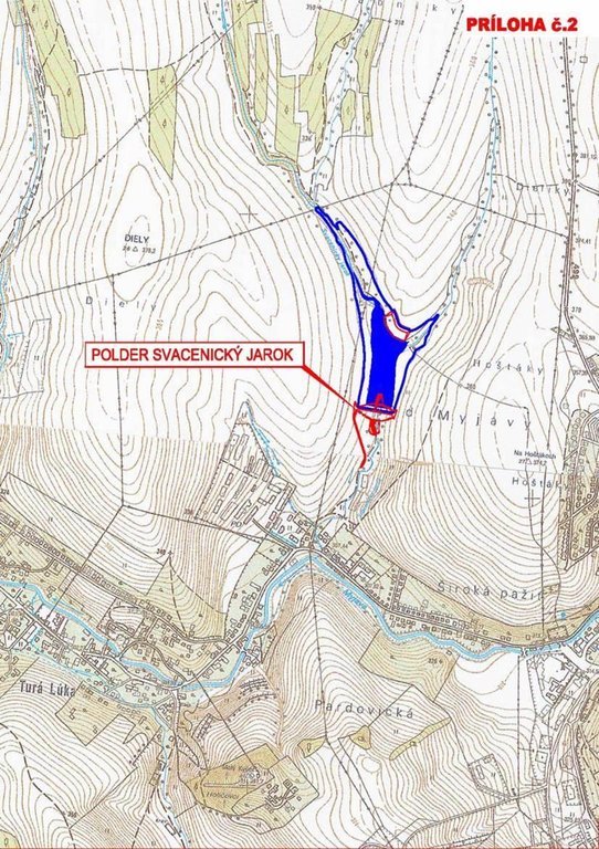
Natural / human environment: The Svacenický creek polder is part of the flood protection of the area, which is located in the west of Slovakia in the cadastral area of the town of Myjava, in the locality of Tura Luka. The town of Myjava has been plagued by frequent floods in recent years, which have resulted in significant material damage, thereby severely hampering the quality of the local residents´ lives.

地点

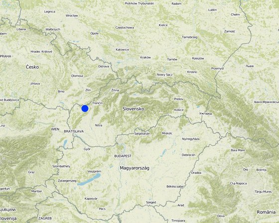
地点: Myjava / Turá Lúka, Slovakia / Trenčiansky region, 斯洛伐克

分析的技术场所数量:

选定地点的地理参考
  • 17.5503, 48.75412

技术传播: 均匀地分布在一个区域 (approx. < 0.1 平方千米(10 公顷))

在永久保护区?:

实施日期: 10-50年前

介绍类型
Flood-Control Reservoir

技术分类

主要目的
  • 改良生产
  • 减少、预防、恢复土地退化
  • 保护生态系统
  • 结合其他技术保护流域/下游区域
  • 保持/提高生物多样性
  • 降低灾害风险
  • 适应气候变化/极端天气及其影响
  • 减缓气候变化及其影响
  • 创造有益的经济影响
  • 创造有益的社会影响
土地利用

  • 农田
    • 一年一作
    每年的生长季节数: 1
  • 水道、水体、湿地 - 排水管道、水道, 池塘、大坝
供水
  • 雨养
  • 混合雨水灌溉
  • 充分灌溉

土地退化相关的目的
  • 防止土地退化
  • 减少土地退化
  • 修复/恢复严重退化的土地
  • 适应土地退化
  • 不适用
解决的退化问题
  • 土壤水蚀 - Wg:冲沟侵蚀/沟蚀 , Wm:块体运动/滑坡
SLM组
  • 地表水管理(泉、河、湖、海)
SLM措施
  • 植物措施 - V1:乔木和灌木覆盖层, V2:草和多年生草本植物
  • 结构措施 - S5:大坝、集水斗、水池

技术图纸

技术规范
This technical drawing shows where the reservoir is localized. Blue colour presents the reservoir, red represents a complex hydraulic facility that is situated by the polder.

Location: The town of Myjava - the locality of Turá Lúka. Slovakia

Technical knowledge required for field staff / advisors: low

Technical knowledge required for land users: low

Technical knowledge required for Design and construction engineers: high (The preparatory and design documentation is needed.)

Main technical functions: control of concentrated runoff: retain / trap

Secondary technical functions: stabilisation of soil (eg by tree roots against land slides)

Aligned: -linear
Vegetative material: G : grass

Scattered / dispersed
Vegetative material: T : trees / shrubs, F : fruit trees / shrubs

Trees/ shrubs species: together 50 000 plants

Specification of dams/ pans/ ponds: Capacity 215,800m3

Catchment area: 6 km2m2

Beneficial area: 3 ham2

Slope of dam wall inside: -%;
Slope of dam wall outside: -%

Dimensions of spillways: -m

Other specifications: -

Vegetation is used for stabilisation of structures.

技术建立与维护:活动、投入和费用

投入和成本的计算
  • 计算的成本为:
  • 成本计算使用的货币:euro
  • 汇率(换算为美元):1 美元 = 0.91 euro
  • 雇用劳工的每日平均工资成本:不适用
影响成本的最重要因素
The most determinate factors that affect the costs are realization works and material used, and repurchase of land.
技术建立活动
n.a.
技术维护活动
n.a.

自然环境

年平均降雨量
  • < 250毫米
  • 251-500毫米
  • 501-750毫米
  • 751-1,000毫米
  • 1,001-1,500毫米
  • 1,501-2,000毫米
  • 2,001-3,000毫米
  • 3,001-4,000毫米
  • > 4,000毫米
农业气候带
  • 潮湿的
  • 半湿润
  • 半干旱
  • 干旱
关于气候的规范
Thermal climate class: temperate
斜坡
  • 水平(0-2%)
  • 缓降(3-5%)
  • 平缓(6-10%)
  • 滚坡(11-15%)
  • 崎岖(16-30%)
  • 陡峭(31-60%)
  • 非常陡峭(>60%)
地形
  • 高原/平原
  • 山脊
  • 山坡
  • 山地斜坡
  • 麓坡
  • 谷底
海拔
  • 0-100 m a.s.l.
  • 101-500 m a.s.l.
  • 501-1,000 m a.s.l.
  • 1,001-1,500 m a.s.l.
  • 1,501-2,000 m a.s.l.
  • 2,001-2,500 m a.s.l.
  • 2,501-3,000 m a.s.l.
  • 3,001-4,000 m a.s.l.
  • > 4,000 m a.s.l.
......应用的技术
  • 凸形情况
  • 凹陷情况
  • 不相关
土壤深度
  • 非常浅(0-20厘米)
  • 浅(21-50厘米)
  • 中等深度(51-80厘米)
  • 深(81-120厘米)
  • 非常深(> 120厘米)
土壤质地(表土)
  • 粗粒/轻(砂质)
  • 中粒(壤土、粉土)
  • 细粒/重质(粘土)
土壤质地(地表以下>20厘米)
  • 粗粒/轻(砂质)
  • 中粒(壤土、粉土)
  • 细粒/重质(粘土)
表土有机质含量
  • 高(>3%)
  • 中(1-3%)
  • 低(<1%)
地下水位
  • 表面上
  • < 5米
  • 5-50米
  • > 50米
地表水的可用性
  • 过量
  • 中等
  • 匮乏/没有
水质(未处理)
  • 良好饮用水
  • 不良饮用水(需要处理)
  • 仅供农业使用(灌溉)
  • 不可用
水质请参考:
盐度是个问题吗?

洪水发生
物种多样性
  • 中等
栖息地多样性
  • 中等

应用该技术的土地使用者的特征

市场定位
  • 生计(自给)
  • 混合(生计/商业)
  • 商业/市场
非农收入
  • 低于全部收入的10%
  • 收入的10-50%
  • > 收入的50%
相对财富水平
  • 非常贫瘠
  • 贫瘠
  • 平均水平
  • 丰富
  • 非常丰富
机械化水平
  • 手工作业
  • 畜力牵引
  • 机械化/电动
定栖或游牧
  • 定栖的
  • 半游牧的
  • 游牧的
个人或集体
  • 个人/家庭
  • 团体/社区
  • 合作社
  • 员工(公司、政府)
性别
  • 女人
  • 男人
年龄
  • 儿童
  • 青年人
  • 中年人
  • 老年人
每户使用面积
  • < 0.5 公顷
  • 0.5-1 公顷
  • 1-2 公顷
  • 2-5公顷
  • 5-15公顷
  • 15-50公顷
  • 50-100公顷
  • 100-500公顷
  • 500-1,000公顷
  • 1,000-10,000公顷
  • > 10,000公顷
规模
  • 小规模的
  • 中等规模的
  • 大规模的
土地所有权
  • 公司
  • 社区/村庄
  • 团体
  • 个人,未命名
  • 个人,有命名
土地使用权
  • 自由进入(无组织)
  • 社区(有组织)
  • 租赁
  • 个人
用水权
  • 自由进入(无组织)
  • 社区(有组织)
  • 租赁
  • 个人
进入服务和基础设施的通道
健康

贫瘠
x
教育

贫瘠
x
技术援助

贫瘠
x
就业(例如非农)

贫瘠
x
市场

贫瘠
x
能源

贫瘠
x
道路和交通

贫瘠
x
饮用水和卫生设施

贫瘠
x
金融服务

贫瘠
x

影响

社会经济影响
社会文化影响
Improved livelihoods and human well-being
decreased
x
increased


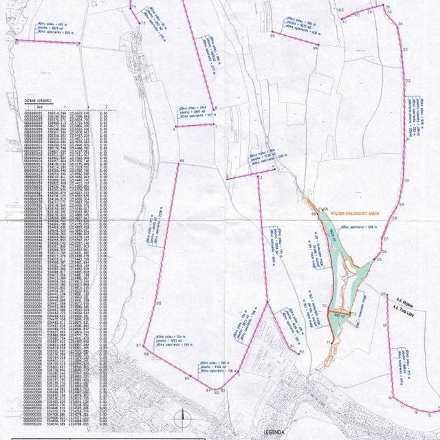
The technology had a positive impact on the natural monument river Myjava. These are: - Reduction of catastrophic floods in the Tura Luka profile approx. 10% - Minimum flows also increased water runoff approx. 10%

生态影响
栖息地多样性
降低
x
增加


Destruction of the use of certain habitats

Risk towards adverse events
improved
x
reduced


Reduced risk of flooding and thereby material damage.

Flood discharge in the Myjava river
increased
x
decreased


10 % decrease of flood discharge

Flood discharge in the Svacenický creelk
increased
x
decreased

New possibilities
decreased
x
increased


New water reservoir
New habitats

Removal of riparian vegetation
increased
x
decreased


Temporary

场外影响
旱季稳定可靠的水流(包括低流量)
减少
x
增加

下游洪水(不希望)
增加
x
减少

对公共/私人基础设施的破坏
增加
x
减少

成本效益分析

与技术建立成本相比的效益
与技术维护成本相比的效益
No information about maintenance costs was given.

气候变化

渐变气候
年温度 增加

非常不好
x
非常好
气候有关的极端情况(灾害)
局地暴雨

非常不好
x
非常好
局地风暴

非常不好
非常好
答案:未知
干旱

非常不好
x
非常好
比较和缓的(河道)洪水

非常不好
x
非常好
其他气候相关的后果
缩短生长期

非常不好
x
非常好

采用和适应

采用该技术的地区内土地使用者的百分比
  • 单例/实验
  • 1-10%
  • 11-50%
  • > 50%
在所有采用这种技术的人当中,有多少人在没有获得物质奖励的情况下采用了这种技术?
  • 0-10%
  • 11-50%
  • 51-90%
  • 91-100%
最近是否对该技术进行了修改以适应不断变化的条件?
什么样的变化条件?
  • 气候变化/极端气候
  • 不断变化的市场
  • 劳动力可用性(例如,由于迁移)

结论和吸取的教训

长处: 土地使用者的观点
长处: 编制者或其他关键资源人员的观点
  • reduction of catastrophic floods in the Tura Luka profile by approx. 10%
  • change in the landscape´s structure, provides a new landscape element – a water area and newly constructed accompanying greenery
  • Minimum flows increased by approx. 10%
  • The construction of the polder will bring about new and improved conditions for other organisms, as it will create new habitats.
弱点/缺点/风险: 土地使用者的观点如何克服
弱点/缺点/风险: 编制者或其他关键资源人员的观点如何克服
  • During the construction and operations arable land will not be usable.
  • Construction of the polder will create a new water area, but in terms of the technical design, the construction will not affect the water table in the greater area.
  • The effects on the air quality during the construction are normally associated with an increased risk of dust (construction, transport), but this will have a short-term impact.
  • There will be a temporary cessation of the use of certain habitats as a result of the taking of the land. It is expected that during the construction, trees will be cut down or damaged or that those habitats that are located in the bank vegetation of the Svacenicky creek and its immediate vicinity will disappear. This activity will affect approx. 0.35% of the entire length of the original riverbed. The taking of the land may result in injury or death to small mammals.

参考文献

编制者
  • Zuzana Studvova
Editors
审查者
  • Fabian Ottiger
  • Alexandra Gavilano
实施日期: April 24, 2015
上次更新: June 20, 2019
资源人
WOCAT数据库中的完整描述
链接的SLM数据
文件编制者
机构 项目
主要参考文献
  • http://www.enviroportal.sk/sk_SK/eia/detail/polder-svacenicky-jarok-myjava http://vodotika.sk/projects/polder-svacenicky-jarok/ http://www.vahostav-sk.sk/galeria-vahostav/vodohospodarske-stavby/protipovodnove-ochrany/polder-svacenicky-jarok-myjava:
This work is licensed under Creative Commons Attribution-NonCommercial-ShareaAlike 4.0 International