Water retention basin, a flood-control reservoir [斯洛伐克]
- 创建:
- 更新:
- 编制者: Zuzana Studvova
- 编辑者: –
- 审查者: Fabian Ottiger, Alexandra Gavilano
Polder (Slovak language)
technologies_1675 - 斯洛伐克
查看章节
全部展开 全部收起1. 一般信息
1.2 参与该技术评估和文件编制的资源人员和机构的联系方式
有助于对技术进行记录/评估的项目名称(如相关)
Preventing and Remediating degradation of soils in Europe through Land Care (EU-RECARE )有助于对技术进行记录/评估的机构名称(如相关)
Slovak University of Technology (Slovak University of Technology) - 斯洛伐克1.3 关于使用通过WOCAT记录的数据的条件
编制者和关键资源人员接受有关使用通过WOCAT记录数据的条件。:
是
2. SLM技术的说明
2.1 技术简介
技术定义:
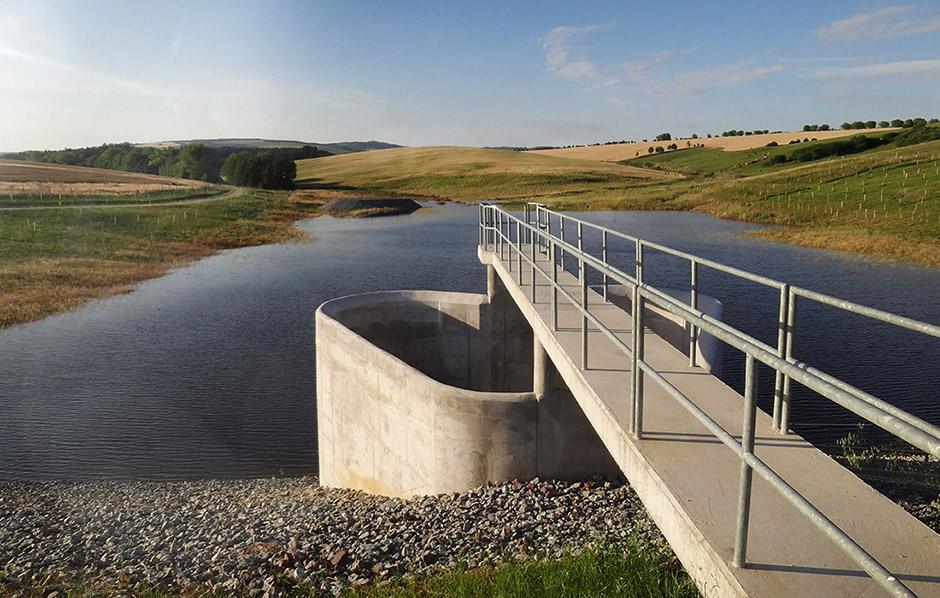
Flood-Control Reservoir - a complex hydraulic facility
2.2 技术的详细说明
说明:
The construction is designed to prevent the flooding of the territory located behind the structure, to eliminate the threat of floods caused by storm rainfall and inappropriate farming, and to reduce flow fluctuation.
Purpose of the Technology: The Svacenický creek polder was built to transform Q100 flood waves.
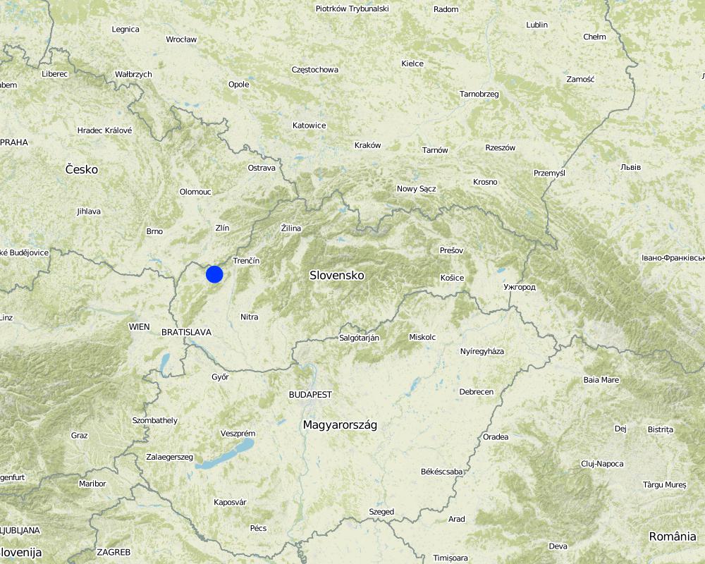
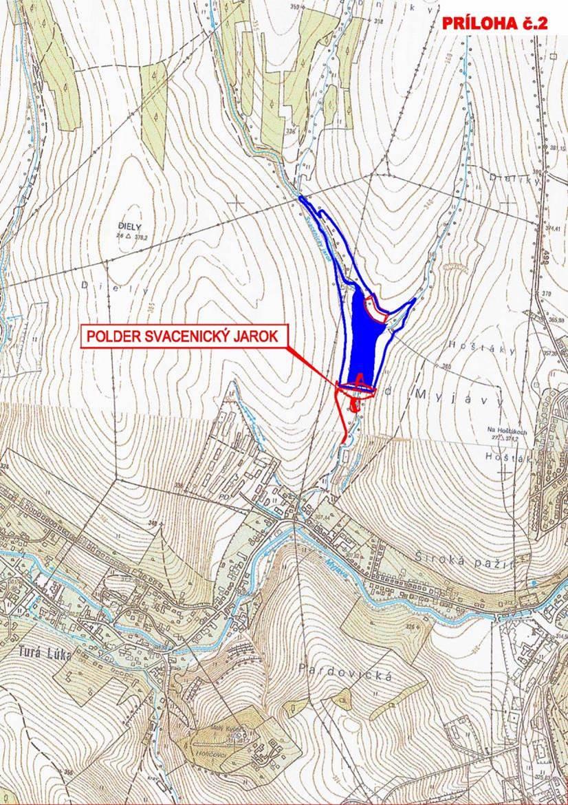
Natural / human environment: The Svacenický creek polder is part of the flood protection of the area, which is located in the west of Slovakia in the cadastral area of the town of Myjava, in the locality of Tura Luka. The town of Myjava has been plagued by frequent floods in recent years, which have resulted in significant material damage, thereby severely hampering the quality of the local residents´ lives.
2.3 技术照片
媒体库
2.5 已应用该技术的、本评估所涵盖的国家/地区/地点
国家:
斯洛伐克
区域/州/省:
Slovakia / Trenčiansky region
有关地点的进一步说明:
Myjava / Turá Lúka
具体说明该技术的分布:
- 均匀地分布在一个区域
如果不知道精确的区域,请注明大致覆盖的区域:
- < 0.1 平方千米(10 公顷)
注释:
The reservoir is situated at the Svacenický Creek.
Map
×2.6 实施日期
如果不知道确切的年份,请说明大概的日期:
- 10-50年前
2.7 技术介绍
详细说明该技术是如何引入的:
- 通过项目/外部干预
3. SLM技术的分类
3.2 应用该技术的当前土地利用类型

农田
- 一年一作
每年的生长季节数:
- 1
具体说明:
Longest growing period in days: 180Longest growing period from month to month: April to September

水道、水体、湿地
- 排水管道、水道
- 池塘、大坝
注释:
Major land use problems (compiler’s opinion): Generation of gulllies.
Major land use problems (land users’ perception): Generation of gulllies and landslides.
Future (final) land use (after implementation of SLM Technology): Other: Ow: Waterways, drainage lines, ponds, dams
3.3 由于技术的实施,土地使用是否发生了变化?
由于技术的实施,土地使用是否发生了变化?:
- 是(请在技术实施前填写以下有关土地利用的问题)
农田
- 一年一作
3.4 供水
该技术所应用土地的供水:
- 混合雨水灌溉
3.5 该技术所属的SLM组
- 地表水管理(泉、河、湖、海)
3.6 包含该技术的可持续土地管理措施

植物措施
- V1:乔木和灌木覆盖层
- V2:草和多年生草本植物

结构措施
- S5:大坝、集水斗、水池
注释:
Main measures: structural measures
Secondary measures: vegetative measures
Type of vegetative measures: scattered / dispersed
3.7 该技术强调的主要土地退化类型

土壤水蚀
- Wg:冲沟侵蚀/沟蚀
- Wm:块体运动/滑坡
注释:
Main type of degradation addressed: Wm: mass movements / landslides
Secondary types of degradation addressed: Wg: gully erosion / gullying
Main causes of degradation: Heavy / extreme rainfall (intensity/amounts), floods
Secondary causes of degradation: soil management, crop management (annual, perennial, tree/shrub)
3.8 防止、减少或恢复土地退化
具体数量名该技术与土地退化有关的目标:
- 防止土地退化
注释:
Main goals: prevention of land degradation
4. 技术规范、实施活动、投入和成本
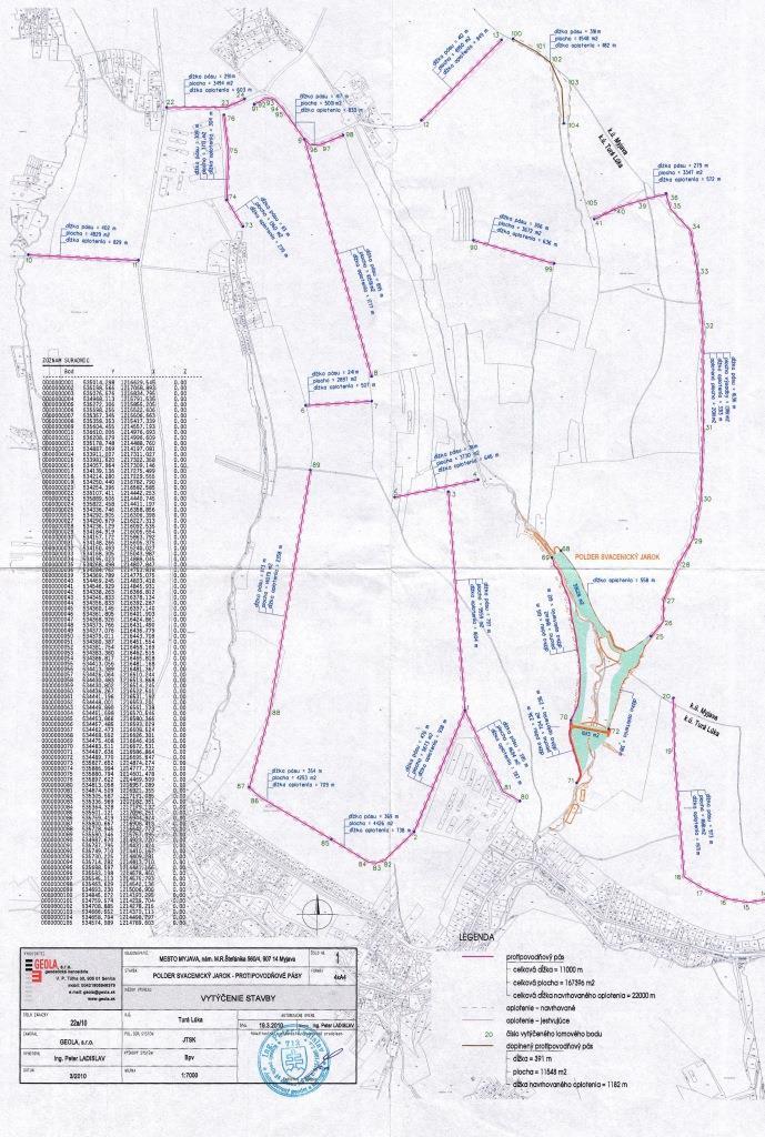
4.1 该技术的技术图纸
技术规范(与技术图纸相关):
This technical drawing shows where the reservoir is localized. Blue colour presents the reservoir, red represents a complex hydraulic facility that is situated by the polder.
Location: The town of Myjava - the locality of Turá Lúka. Slovakia
Technical knowledge required for field staff / advisors: low
Technical knowledge required for land users: low
Technical knowledge required for Design and construction engineers: high (The preparatory and design documentation is needed.)
Main technical functions: control of concentrated runoff: retain / trap
Secondary technical functions: stabilisation of soil (eg by tree roots against land slides)
Aligned: -linear
Vegetative material: G : grass
Scattered / dispersed
Vegetative material: T : trees / shrubs, F : fruit trees / shrubs
Trees/ shrubs species: together 50 000 plants
Specification of dams/ pans/ ponds: Capacity 215,800m3
Catchment area: 6 km2m2
Beneficial area: 3 ham2
Slope of dam wall inside: -%;
Slope of dam wall outside: -%
Dimensions of spillways: -m
Other specifications: -
Vegetation is used for stabilisation of structures.
4.2 有关投入和成本计算的一般信息
其它/国家货币(具体说明):
euro
如相关,注明美元与当地货币的汇率(例如1美元=79.9巴西雷亚尔):1美元=:
0.91
4.6 维护/经常性活动所需要的费用和投入(每年)
注释:
The list of main activities:1/Land purchase (144849.574 USD),2/ Preparatory and design documentation (49305.338 USD), 3/Construction works (2345530.958 USD), 4/Constuction supervision (40135.48 USD), 5/Supporting activities (dissemination 494.55 USD, project management 40098.993 USD).
4.7 影响成本的最重要因素
描述影响成本的最决定性因素:
The most determinate factors that affect the costs are realization works and material used, and repurchase of land.
5. 自然和人文环境
5.1 气候
年降雨量
- < 250毫米
- 251-500毫米
- 501-750毫米
- 751-1,000毫米
- 1,001-1,500毫米
- 1,501-2,000毫米
- 2,001-3,000毫米
- 3,001-4,000毫米
- > 4,000毫米
农业气候带
- 半湿润
Thermal climate class: temperate
5.2 地形
平均坡度:
- 水平(0-2%)
- 缓降(3-5%)
- 平缓(6-10%)
- 滚坡(11-15%)
- 崎岖(16-30%)
- 陡峭(31-60%)
- 非常陡峭(>60%)
地形:
- 高原/平原
- 山脊
- 山坡
- 山地斜坡
- 麓坡
- 谷底
垂直分布带:
- 0-100 m a.s.l.
- 101-500 m a.s.l.
- 501-1,000 m a.s.l.
- 1,001-1,500 m a.s.l.
- 1,501-2,000 m a.s.l.
- 2,001-2,500 m a.s.l.
- 2,501-3,000 m a.s.l.
- 3,001-4,000 m a.s.l.
- > 4,000 m a.s.l.
关于地形的注释和进一步规范:
Altitudinal zone: 101-500 m a.s.l. (370-400 m a.s.l.)
5.3 土壤
平均土层深度:
- 非常浅(0-20厘米)
- 浅(21-50厘米)
- 中等深度(51-80厘米)
- 深(81-120厘米)
- 非常深(> 120厘米)
土壤质地(表土):
- 中粒(壤土、粉土)
- 细粒/重质(粘土)
5.4 水资源可用性和质量
水质(未处理):
良好饮用水
5.6 应用该技术的土地使用者的特征
相对财富水平:
- 平均水平
机械化水平:
- 机械化/电动
说明土地使用者的其他有关特征:
Population density: 50-100 persons/km2
Market orientation of production system: subsistence (self-supply), mixed (subsistence/ commercial, commercial/ market
5.7 应用该技术的土地使用者使用的平均土地面积
- < 0.5 公顷
- 0.5-1 公顷
- 1-2 公顷
- 2-5公顷
- 5-15公顷
- 15-50公顷
- 50-100公顷
- 100-500公顷
- 500-1,000公顷
- 1,000-10,000公顷
- > 10,000公顷
注释:
Average area of land owned or leased by land users applying the Technology: Also 1-2 ha
5.8 土地所有权、土地使用权和水使用权
土地使用权:
- 社区(有组织)
注释:
Land ownership: state, communal / village, individual, not titled
5.9 进入服务和基础设施的通道
健康:
- 贫瘠
- 适度的
- 好
教育:
- 贫瘠
- 适度的
- 好
技术援助:
- 贫瘠
- 适度的
- 好
就业(例如非农):
- 贫瘠
- 适度的
- 好
市场:
- 贫瘠
- 适度的
- 好
能源:
- 贫瘠
- 适度的
- 好
道路和交通:
- 贫瘠
- 适度的
- 好
饮用水和卫生设施:
- 贫瘠
- 适度的
- 好
金融服务:
- 贫瘠
- 适度的
- 好
6. 影响和结论性说明
6.1 该技术的现场影响
社会文化影响
Improved livelihoods and human well-being
注释/具体说明:
The technology had a positive impact on the natural monument river Myjava. These are: - Reduction of catastrophic floods in the Tura Luka profile approx. 10% - Minimum flows also increased water runoff approx. 10%
生态影响
生物多样性:植被、动物
栖息地多样性
注释/具体说明:
Destruction of the use of certain habitats
其它生态影响
Risk towards adverse events
注释/具体说明:
Reduced risk of flooding and thereby material damage.
Flood discharge in the Myjava river
注释/具体说明:
10 % decrease of flood discharge
Flood discharge in the Svacenický creelk
New possibilities
注释/具体说明:
New water reservoir
New habitats
Removal of riparian vegetation
注释/具体说明:
Temporary
6.2 该技术的场外影响已经显现
旱季稳定可靠的水流
下游洪水
对公共/私人基础设施的破坏
6.3 技术对渐变气候以及与气候相关的极端情况/灾害的暴露和敏感性(土地使用者认为的极端情况/灾害)
渐变气候
渐变气候
| 季节 | 增加或减少 | 该技术是如何应对的? | |
|---|---|---|---|
| 年温度 | 增加 | 好 |
气候有关的极端情况(灾害)
气象灾害
| 该技术是如何应对的? | |
|---|---|
| 局地暴雨 | 好 |
| 局地风暴 | 未知 |
气候灾害
| 该技术是如何应对的? | |
|---|---|
| 干旱 | 好 |
水文灾害
| 该技术是如何应对的? | |
|---|---|
| 比较和缓的(河道)洪水 | 好 |
其他气候相关的后果
其他气候相关的后果
| 该技术是如何应对的? | |
|---|---|
| 缩短生长期 | 好 |
6.4 成本效益分析
注释:
No information about maintenance costs was given.
6.7 该技术的优点/长处/机会
| 编制者或其他关键资源人员认为的长处/优势/机会 |
|---|
| reduction of catastrophic floods in the Tura Luka profile by approx. 10% |
| change in the landscape´s structure, provides a new landscape element – a water area and newly constructed accompanying greenery |
| Minimum flows increased by approx. 10% |
| The construction of the polder will bring about new and improved conditions for other organisms, as it will create new habitats. |
6.8 技术的弱点/缺点/风险及其克服方法
| 编制者或其他关键资源人员认为的弱点/缺点/风险 | 如何克服它们? |
|---|---|
| During the construction and operations arable land will not be usable. | |
| Construction of the polder will create a new water area, but in terms of the technical design, the construction will not affect the water table in the greater area. | |
| The effects on the air quality during the construction are normally associated with an increased risk of dust (construction, transport), but this will have a short-term impact. | |
| There will be a temporary cessation of the use of certain habitats as a result of the taking of the land. It is expected that during the construction, trees will be cut down or damaged or that those habitats that are located in the bank vegetation of the Svacenicky creek and its immediate vicinity will disappear. This activity will affect approx. 0.35% of the entire length of the original riverbed. The taking of the land may result in injury or death to small mammals. |
7. 参考和链接
7.2 参考可用出版物
标题、作者、年份、ISBN:
http://www.enviroportal.sk/sk_SK/eia/detail/polder-svacenicky-jarok-myjava http://vodotika.sk/projects/polder-svacenicky-jarok/ http://www.vahostav-sk.sk/galeria-vahostav/vodohospodarske-stavby/protipovodnove-ochrany/polder-svacenicky-jarok-myjava
链接和模块
全部展开 全部收起链接
无链接
模块
无模块