Vegetated earth-banked terraces [西班牙]
- 创建:
- 更新:
- 编制者: Joris De Vente
- 编辑者: –
- 审查者: Deborah Niggli, Alexandra Gavilano
Terrazas de tierra vegetadas (Spanish)
technologies_1516 - 西班牙
查看章节
全部展开 全部收起1. 一般信息
1.2 参与该技术评估和文件编制的资源人员和机构的联系方式
SLM专业人员:
SLM专业人员:
López Carratala Jorge
Consejo Superior de Investigaciones Científicas, Estación Experimental de Zonas Áridas (EEZA-CSIC)
西班牙
有助于对技术进行记录/评估的项目名称(如相关)
DESIRE (EU-DES!RE)有助于对技术进行记录/评估的机构名称(如相关)
EEZA-CSIC (EEZA-CSIC) - 西班牙1.3 关于使用通过WOCAT记录的数据的条件
编制者和关键资源人员接受有关使用通过WOCAT记录数据的条件。:
是
1.5 参考关于SLM方法(使用WOCAT记录的SLM方法)的调查问卷
Regional rural development programme [西班牙]
Regional development programme to protect natural resources and stimulate rural economies.
- 编制者: Joris De Vente
2. SLM技术的说明
2.1 技术简介
技术定义:
Earth-banked terraces in cereal and almond cropland covered with drought-resistant shrubs.
2.2 技术的详细说明
说明:
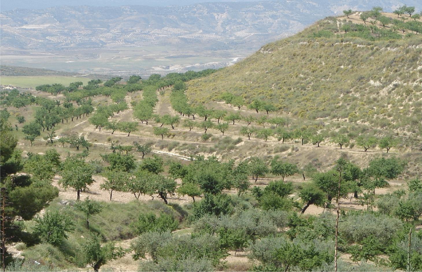
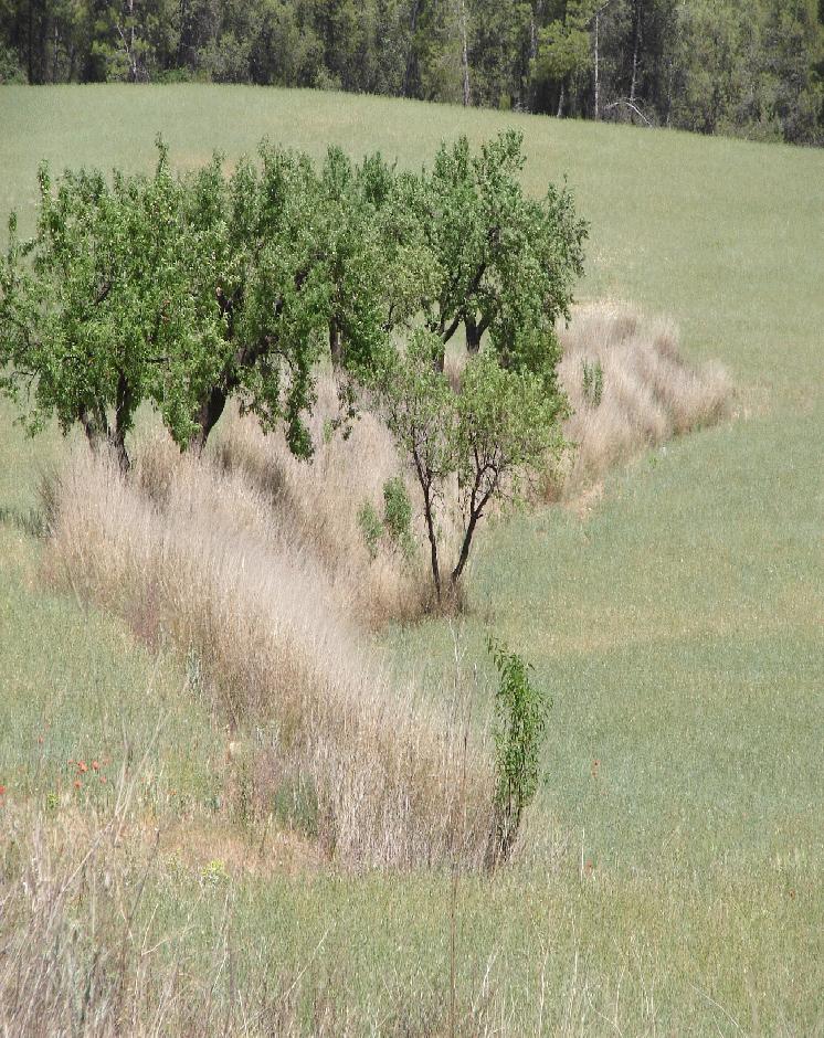
Earth-banked terraces are constructed by carefully removing a superficial soil layer (~10-20 cm) from one part of a field, concentrating it on the lower end of that field in order to reduce slope gradient and length. Another terrace is created directly downslope to form a cascade of terraces. Terrace risers have to be of restricted height (~50-150 cm) to prevent steep and unstable terraces. Stones from the fields can be used to reinforce the terrace ridge. After terrace construction, fields should be gently sloping (<3%) in the direction of the main slope. The distance between terraces must be enough to allow tractor movement during normal cultivation activities and it depends also on the slope gradient. The steeper the slope, the shorter is the distance between terraces. Terraces reduce the formation of gullies and retain water from upslope. The terraces are made with locally available machinery (tractor, small bulldozer). The terrace ridges are optimal locations to plant olives, almonds or fruit trees. Moreover, to be most effective, the terrace ridges are vegetated with shrubs adapted to semi-arid conditions and with a good surface cover (>~30%) throughout the year (e.g. Stipa tenacisima, Rosmarinus officinalis, Thymus vulgaris, Ulex parviflorus, Rhamnus lycioides, Pistacia lentiscus). Natural regeneration of vegetation is allowed without limitation on the terrace ridges, so no herbicide application or burning are carried out to remove weeds. Where possible, regeneration should be stimulated by planting the same adapted species in at least 25% of the terrace ridge. Optionally, in the other 75% of the terrace ridge, cereals or other leguminous species can be sown, but should not be harvested or used for grazing.
Purpose of the Technology: This technology reduces flooding, damage to infrastructure and siltation of water reservoirs, while maintaining (or slightly increasing) crop productivity. This is achieved by reducing runoff, soil erosion and hydraulic connectivity through a decreased slope gradient and an increased vegetation cover. The terrace ridge functions as a sink for runoff within fields and reduces runoff velocity. The vegetation leads to increased soil organic matter content below plants, producing an improved soil structure and a higher infiltration capacity. The use of stones from the fields to reinforce the terraces is optional, but facilitates crop production in the fields and makes the ridges more resistant to higher runoff velocities. The technology requires an initial investment in the construction of the terraces. Terraces can best be located on thalwegs and on areas where gully formation is often observed. Maintenance consists of filling up possible bank gullies developed in the terraces after important rainfall events and, if needed, substitute decayed shrubs with new ones.
Natural / human environment: The technology is generally applied on soils of shallow to medium depth (20 – 60 cm), and slopes are gentle to moderate (5-15%). The climate is semi-arid with a mean annual rainfall around 300 mm. Droughts, peaking in summer commonly last for more than 4-5 months. Annual potential evapotranspiration rates larger than 1000 mm are common. The production system is highly mechanized and market-oriented but depends strongly on agricultural subsidies. All cropland is privately-owned.
2.3 技术照片
媒体库
2.5 已应用该技术的、本评估所涵盖的国家/地区/地点
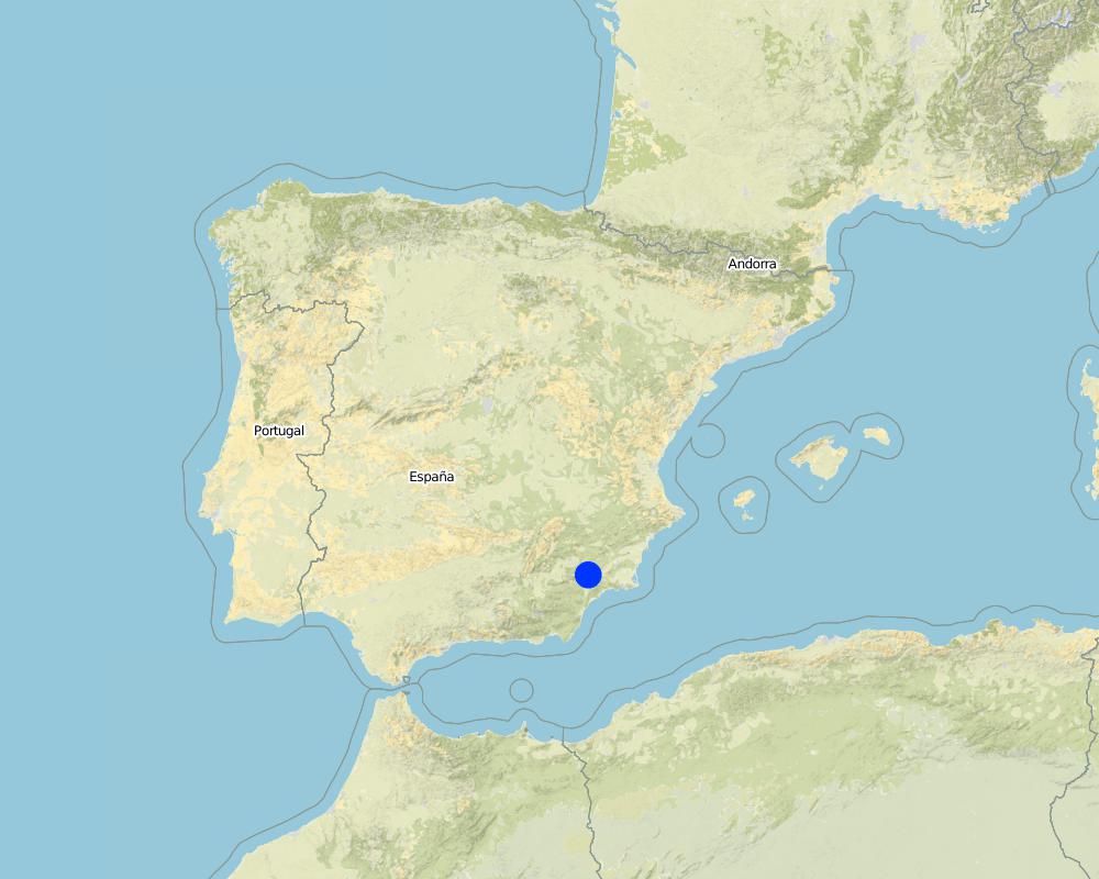
国家:
西班牙
区域/州/省:
Murcia
有关地点的进一步说明:
Guadalentin catchment
具体说明该技术的分布:
- 均匀地分布在一个区域
如果不知道精确的区域,请注明大致覆盖的区域:
- 10-100 平方千米
Map
×2.6 实施日期
如果不知道确切的年份,请说明大概的日期:
- 50多年前(传统)
2.7 技术介绍
详细说明该技术是如何引入的:
- 作为传统系统的一部分(> 50 年)
注释(项目类型等):
Most of the earthen terraces are already much older than 50 years. Recently, the regional administration is promoting clearly defined vegetated strips with minimum dimensions in order to apply for subsidies.
3. SLM技术的分类
3.2 应用该技术的当前土地利用类型
同一土地单元内混合使用的土地::
是
具体说明混合土地使用(作物/放牧/树木):
- 农林业

农田
- 一年一作
- 乔木与灌木的种植
乔木和灌木种植 - 指定作物:
- 树坚果(巴西坚果、开心果、核桃、杏仁等)
每年的生长季节数:
- 1
具体说明:
Longest growing period in days: 220Longest growing period from month to month: November to June

牧场

森林/林地
- (半天然)天然森林/林地
注释:
Major land use problems (compiler’s opinion): A lack of water availability seriously limits the production potential of the soil and results in a low vegetation/crop cover. The relatively high soil erosion rates cause various off-site related problems (i.e. flooding, reservoir siltation) and on-site problems (i.e. gully formation and loss of soil depth).
Major land use problems (land users’ perception): Lack of water for irrigation of crops limiting the crop types that can be planted as well as the crop yield of dryland farming.
Number of growing seasons per year:
1
Specify:
Longest growing period in days: 220Longest growing period from month to month: November to June
3.5 该技术所属的SLM组
- 改良的地面/植被覆盖
- 横坡措施
3.6 包含该技术的可持续土地管理措施

植物措施
- V1:乔木和灌木覆盖层
- V2:草和多年生草本植物

结构措施
- S1:阶地
注释:
Main measures: vegetative measures, structural measures
Type of vegetative measures: aligned: -contour
3.7 该技术强调的主要土地退化类型

土壤水蚀
- Wt:表土流失/地表侵蚀
- Wg:冲沟侵蚀/沟蚀
- Wo:场外劣化效应

水质恶化
- Ha:干旱化
注释:
Main type of degradation addressed: Wt: loss of topsoil / surface erosion, Wg: gully erosion / gullying, Wo: offsite degradation effects
Secondary types of degradation addressed: Ha: aridification
Main causes of degradation: crop management (annual, perennial, tree/shrub) (Almond and cereal fields often have a relatively low surface cover by vegetation during long periods of the year, leaving the soil unprotected against raindrop impact and rill or gully formation), disturbance of water cycle (infiltration / runoff) (Reduced infiltration capacity causing runoff and soil erosion), other human induced causes (specify) (Cropping of relatively steep slopes sensitive to erosion because of slope gradient), governance / institutional (spatial planning of land use results in formation of too large fields without field boundaries)
Secondary causes of degradation: Heavy / extreme rainfall (intensity/amounts) (High intensity erosive rainfall is common), droughts (Dry periods and dry years require higher water availability)
3.8 防止、减少或恢复土地退化
具体数量名该技术与土地退化有关的目标:
- 防止土地退化
- 减少土地退化
注释:
Main goals: prevention of land degradation, mitigation / reduction of land degradation
4. 技术规范、实施活动、投入和成本
4.1 该技术的技术图纸
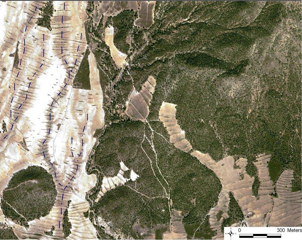
技术规范(与技术图纸相关):
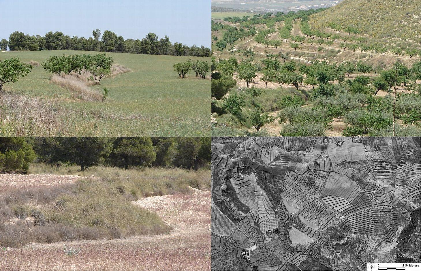
Quickbird satellite image showing the concentration of terraces along natural drainage lines (thalwegs) where runoff concentrates. Drainage lines are indicated with dotted lines.
Location: Torrealvillla. Murcia
Date: Satellite image 2003
Technical knowledge required for field staff / advisors: moderate (Design of the terraces and selection of the location requires some technical knowledge.)
Technical knowledge required for land users: low (Practical implementation of the terraces does not require a high level of knowledge)
Main technical functions: control of dispersed runoff: retain / trap, control of dispersed runoff: impede / retard, control of concentrated runoff: retain / trap, control of concentrated runoff: impede / retard, reduction of slope angle, increase of infiltration, increase / maintain water stored in soil
Secondary technical functions: reduction of slope length, improvement of ground cover, stabilisation of soil (eg by tree roots against land slides), increase in organic matter, water harvesting / increase water supply, sediment retention / trapping, sediment harvesting, spatial arrangement and diversification of land use
Aligned: -contour
Vegetative material: F : fruit trees / shrubs
Number of plants per (ha): 42
Vertical interval between rows / strips / blocks (m): 1
Spacing between rows / strips / blocks (m): 30-100
Vertical interval within rows / strips / blocks (m): 0.5-7
Width within rows / strips / blocks (m): 2
Vegetative measure: alligned: contour
Vegetative material: G : grass
Number of plants per (ha): >30% cover
Vertical interval between rows / strips / blocks (m): 1
Spacing between rows / strips / blocks (m): 30-100
Vertical interval within rows / strips / blocks (m): 0.5
Width within rows / strips / blocks (m): 2
Vegetative measure: Vegetative material: G : grass
Vegetative measure: Vegetative material: G : grass
Vegetative measure: Vegetative material: G : grass
Fruit trees / shrubs species: natural regeneration of shrubs with possible additional plantation of almond trees and/or woody shru
Grass species: Natural regeneration assisted by seeding of legiminous species and cereals
Slope (which determines the spacing indicated above): 10.00%
Terrace: forward sloping
Vertical interval between structures (m): 1
Spacing between structures (m): 30-100
Height of bunds/banks/others (m): 0.5-1.5
Width of bunds/banks/others (m): 2
Length of bunds/banks/others (m): 50-200
Construction material (stone): Only when many stones are present in the fields
Slope (which determines the spacing indicated above): 5-15%
If the original slope has changed as a result of the Technology, the slope today is: <3%
Lateral gradient along the structure: 0%
Vegetation is used for stabilisation of structures.
作者:
Joris de Vente
4.2 有关投入和成本计算的一般信息
其它/国家货币(具体说明):
EURO
如相关,注明美元与当地货币的汇率(例如1美元=79.9巴西雷亚尔):1美元=:
0.63
注明雇用劳工的每日平均工资成本:
79.00
4.3 技术建立活动
| 活动 | 时间(季度) | |
|---|---|---|
| 1. | Plantation of shrubs and cereals or Leguminous species (optional) | Autumn - winter |
| 2. | Construction of terraces | autumn or winter |
4.4 技术建立所需要的费用和投入
| 对投入进行具体说明 | 单位 | 数量 | 单位成本 | 每项投入的总成本 | 土地使用者承担的成本% | |
|---|---|---|---|---|---|---|
| 劳动力 | Labour | ha | 1.0 | 270.0 | 270.0 | 10.0 |
| 设备 | Machine use | ha | 1.0 | 428.0 | 428.0 | 12.0 |
| 植物材料 | shrub seedlings and seeds | ha | 1.0 | 218.0 | 218.0 | 10.0 |
| 技术建立所需总成本 | 916.0 | |||||
| 技术建立总成本,美元 | 1453.97 | |||||
注释:
Duration of establishment phase: 12 month(s)
4.5 维护/经常性活动
| 活动 | 时间/频率 | |
|---|---|---|
| 1. | Replace died shrubs (optional) | autumn-winter |
| 2. | Filling up bank gullies in terraces | twice a year or after heavy rainstorms |
4.6 维护/经常性活动所需要的费用和投入(每年)
| 对投入进行具体说明 | 单位 | 数量 | 单位成本 | 每项投入的总成本 | 土地使用者承担的成本% | |
|---|---|---|---|---|---|---|
| 劳动力 | Labour | ha | 1.0 | 28.0 | 28.0 | 10.0 |
| 设备 | Machine use | ha | 1.0 | 24.0 | 24.0 | 10.0 |
| 植物材料 | Shrub seedlings and seeds | ha | 1.0 | 22.0 | 22.0 | 10.0 |
| 技术维护所需总成本 | 74.0 | |||||
| 技术维护总成本,美元 | 117.46 | |||||
注释:
Machinery/ tools: For initial construction a large tractor or small bulldozer is required. For maintanance a normal tractor can be used.
The costs were indicated assuming a distance between terraces of 50 meter, meaning two terraces of 100 meter long per hectare. Prices are for spring 2008. Subsidies are foreseen for the installation of the vegetated terraces and for maintenance during at least 4 years if all requirements are fullfilled that are described in the regional development programme.
4.7 影响成本的最重要因素
描述影响成本的最决定性因素:
Price of fuel and labour are the most important determinants of the costs.
5. 自然和人文环境
5.1 气候
年降雨量
- < 250毫米
- 251-500毫米
- 501-750毫米
- 751-1,000毫米
- 1,001-1,500毫米
- 1,501-2,000毫米
- 2,001-3,000毫米
- 3,001-4,000毫米
- > 4,000毫米
指定年平均降雨量(若已知),单位为mm:
300.00
有关降雨的规范/注释:
Dry period in summer during 3-4 months (June – August/September)
农业气候带
- 半干旱
Thermal climate class: subtropics
Thermal climate class: temperate. The higher parts are generally somewhat colder
5.2 地形
平均坡度:
- 水平(0-2%)
- 缓降(3-5%)
- 平缓(6-10%)
- 滚坡(11-15%)
- 崎岖(16-30%)
- 陡峭(31-60%)
- 非常陡峭(>60%)
地形:
- 高原/平原
- 山脊
- 山坡
- 山地斜坡
- 麓坡
- 谷底
垂直分布带:
- 0-100 m a.s.l.
- 101-500 m a.s.l.
- 501-1,000 m a.s.l.
- 1,001-1,500 m a.s.l.
- 1,501-2,000 m a.s.l.
- 2,001-2,500 m a.s.l.
- 2,501-3,000 m a.s.l.
- 3,001-4,000 m a.s.l.
- > 4,000 m a.s.l.
说明该技术是否专门应用于:
- 凹陷情况
关于地形的注释和进一步规范:
Landforms: Hill slopes-footslopes (mostly on concave slope segments)
5.3 土壤
平均土层深度:
- 非常浅(0-20厘米)
- 浅(21-50厘米)
- 中等深度(51-80厘米)
- 深(81-120厘米)
- 非常深(> 120厘米)
土壤质地(表土):
- 中粒(壤土、粉土)
- 细粒/重质(粘土)
表土有机质:
- 中(1-3%)
- 低(<1%)
5.4 水资源可用性和质量
地下水位表:
5-50米
地表水的可用性:
匮乏/没有
水质(未处理):
仅供农业使用(灌溉)
关于水质和水量的注释和进一步规范:
Ground water table: >50m (There is a lowering of groundwater table due to overexploitation for irrigation purposes)
Availability of surface water: Poor/none (excess: sporadically there are flash floods during extreme rainfall events)
Water quality (untreated): For agricultural use only (irrigation) (groundwater)
5.5 生物多样性
物种多样性:
- 低
5.6 应用该技术的土地使用者的特征
非农收入:
- > 收入的50%
相对财富水平:
- 平均水平
个人或集体:
- 个人/家庭
性别:
- 男人
说明土地使用者的其他有关特征:
Land users applying the Technology are mainly common / average land users
Difference in the involvement of women and men: Traditionally most agriculture is done by men in this region.
Population density: 10-50 persons/km2
Annual population growth: < 0.5%
15% of the land users are rich and own 20% of the land.
80% of the land users are average wealthy and own 75% of the land.
5% of the land users are poor and own 5% of the land.
Off-farm income specification: There is no difference in the ones who apply the technology and those who don’t. Most farmers do have an off-farm income for example from hunting, work in a factory, or office.
5.7 应用该技术的土地使用者使用的平均土地面积
- < 0.5 公顷
- 0.5-1 公顷
- 1-2 公顷
- 2-5公顷
- 5-15公顷
- 15-50公顷
- 50-100公顷
- 100-500公顷
- 500-1,000公顷
- 1,000-10,000公顷
- > 10,000公顷
这被认为是小规模、中规模还是大规模的(参照当地实际情况)?:
- 中等规模的
5.8 土地所有权、土地使用权和水使用权
土地所有权:
- 个人,有命名
土地使用权:
- 个人
用水权:
- 个人
注释:
All cropland is privately owned. Some shrubland or forest is state property. Water use is organised by permits to water extraction from aquifers on individual basis. Water rights are provided and controlled by the Water authority of the Segura river basin (CHS).
5.9 进入服务和基础设施的通道
健康:
- 贫瘠
- 适度的
- 好
教育:
- 贫瘠
- 适度的
- 好
技术援助:
- 贫瘠
- 适度的
- 好
就业(例如非农):
- 贫瘠
- 适度的
- 好
市场:
- 贫瘠
- 适度的
- 好
能源:
- 贫瘠
- 适度的
- 好
道路和交通:
- 贫瘠
- 适度的
- 好
饮用水和卫生设施:
- 贫瘠
- 适度的
- 好
金融服务:
- 贫瘠
- 适度的
- 好
6. 影响和结论性说明
6.1 该技术的现场影响
社会经济效应
生产
作物生产
注释/具体说明:
Depending on local conditions yield may be the same or increase slightly
土地管理
注释/具体说明:
Field paths become shorter, so more tractor movement is required (not more kilometres!)
收入和成本
农业投入费用
注释/具体说明:
Implementation of terraces is considered relatively expensive
农业收入
注释/具体说明:
Depends on crop yield.
工作量
注释/具体说明:
Less damage to fields due to less gully formation
社会文化影响
SLM/土地退化知识
冲突缓解
注释/具体说明:
Less damage to neighbours fields by gullies and flooding
Improved livelihoods and human well-being
注释/具体说明:
There is less damage to fields and to infrastructure due to gully formation and flooding.
生态影响
水循环/径流
水的回收/收集
注释/具体说明:
On the long term higher infiltration capacity of the soil
地表径流
地下水位/含水层
土壤
土壤水分
土壤覆盖层
注释/具体说明:
Vegetation on the terraces increases vegetation cover
土壤流失
土壤有机物/地下C
注释/具体说明:
Provided by the vegetation on the terraces
生物多样性:植被、动物
生物量/地上C
注释/具体说明:
Provided by the vegetation on the terraces
植物多样性
动物多样性
注释/具体说明:
Terraces provide corridors connecting fields and provide shelter
有益物种
栖息地多样性
6.2 该技术的场外影响已经显现
下游洪水
下游淤积
缓冲/过滤能力
对邻近农田的破坏
对公共/私人基础设施的破坏
6.3 技术对渐变气候以及与气候相关的极端情况/灾害的暴露和敏感性(土地使用者认为的极端情况/灾害)
渐变气候
渐变气候
| 季节 | 增加或减少 | 该技术是如何应对的? | |
|---|---|---|---|
| 年温度 | 增加 | 不好 |
注释:
The crop type is sensitive to changes in water availability under the semi arid conditions
6.4 成本效益分析
技术收益与技术建立成本相比如何(从土地使用者的角度看)?
短期回报:
消极
长期回报:
中性/平衡
技术收益与技术维护成本/经常性成本相比如何(从土地使用者的角度看)?
短期回报:
中性/平衡
长期回报:
稍微积极
注释:
Implementation of the terraces is relatively expensive. Additionally planting of shrubs is also relatively expensive and requires a subsidy. Once installed, maintenance is not expensive and pays off because of less damage to fields and infrastructure.
6.5 技术采用
在所有采用这项技术的人当中,有多少人是自发的,即未获得任何物质奖励/付款?:
- 11-50%
注释:
80% of land user families have adopted the Technology with external material support
Comments on acceptance with external material support: Terraces are traditionally widespread in the region. Most of them were installed without external support. Nowadays there are subsidies for construction and maintenance of vegetated strips and terraces.
20% of land user families have adopted the Technology without any external material support
There is no trend towards spontaneous adoption of the Technology
Comments on adoption trend: There is acceptance, but it is not growing. In some parts terraces are removed to make larger fields, and some new ones are also constructed. Recently installed subsidies may change this
6.7 该技术的优点/长处/机会
| 土地使用者眼中的长处/优势/机会 |
|---|
|
The terraces prevent gully formation and damage to the fields and to their neighbours How can they be sustained / enhanced? maintenance is needed and should be promoted. |
| 编制者或其他关键资源人员认为的长处/优势/机会 |
|---|
|
This technology is very effective at reducing surface runoff and erosion by reducing slope gradients and connectivity. In addition, it has a water harvesting effect. So it reduces on-site and off-site erosion problems and potentially increases water retention in the fields. How can they be sustained / enhanced? The technology can be enhanced by providing more info and publicity so that existing terraces are maintained. |
6.8 技术的弱点/缺点/风险及其克服方法
| 土地使用者认为的弱点/缺点/风险 | 如何克服它们? |
|---|---|
| It is considered relatively expensive to implement and particularly the optional planting of woody species is considered complicated in dry years | Subsidies for terrace construction and planting of woody species as well as cooperation between farmers to reduce costs of maintenance when subsidies stop. |
| 编制者或其他关键资源人员认为的弱点/缺点/风险 | 如何克服它们? |
|---|---|
| The technology does not significantly improve farm income and has a significant implementation cost. | Provide information on all the advantages that include many costs for society (including floods, reservoir siltation etc.). The subsidy for implementation already solves the problem of implementation costs. |
7. 参考和链接
7.1 信息的方法/来源
7.2 参考可用出版物
标题、作者、年份、ISBN:
Garcia-Fayos, P. and Gasque, M., 2002. Consequences of a severe drought on spatial patterns of woody plants in a two-phase mosaic steppe of Stipa tenacissima L. Journal of Arid Environments, 52(2): 199-208.
可以从哪里获得?成本如何?
internet
标题、作者、年份、ISBN:
Hooke, J.M., 2006. Human impacts on fluvial systems in the Mediterranean region. Geomorphology, 79(3-4): 311-335.
可以从哪里获得?成本如何?
internet
标题、作者、年份、ISBN:
Kirkby, M.J., Bracken, L.J. and Shannon, J., 2005. The influence of rainfall distribution and morphological factors on runoff delivery from dryland catchments in SE Spain. CATENA, 62(2-3): 136-156.
可以从哪里获得?成本如何?
internet
7.3 链接到网络上的相关信息
标题/说明:
CARM 2008. Programa de Desarrollo Rural de la Región de Murcia 2007-2013 Tomo I. 508pp
URL:
http://www.carm.es/neweb2/servlet/integra.servlets.ControlPublico?IDCONTENIDO=4689&IDTIPO=100&RASTRO=c431$m1219
链接和模块
全部展开 全部收起链接
Regional rural development programme [西班牙]
Regional development programme to protect natural resources and stimulate rural economies.
- 编制者: Joris De Vente
模块
无模块