Grass strips [尼日尔 ]
- 创建:
- 更新:
- 编制者: Dieter Nill
- 编辑者: –
- 审查者: Deborah Niggli, Alexandra Gavilano
Bandes enherbées (French)
technologies_1621 - 尼日尔
查看章节
全部展开 全部收起1. 一般信息
1.2 参与该技术评估和文件编制的资源人员和机构的联系方式
SLM专业人员:
Mamadou Abdou Gaoh Sani
Programme d’Appui à l’agriculture Productive (PROMAP), Niamey, Niger
尼日尔
有助于对技术进行记录/评估的项目名称(如相关)
Good Practices in Soil and Water Conservation - A contribution to adaptation and farmers ́ resilience towards climate change in the Sahel (GIZ)有助于对技术进行记录/评估的机构名称(如相关)
Deutsche Gesellschaft für Internationale Zusammenarbeit (GIZ) - 德国1.3 关于使用通过WOCAT记录的数据的条件
编制者和关键资源人员接受有关使用通过WOCAT记录数据的条件。:
是
1.4 所述技术的可持续性声明
这里所描述的技术在土地退化方面是否存在问题,导致无法被认为是一种可持续的土地管理技术?:
否
2. SLM技术的说明
2.1 技术简介
技术定义:
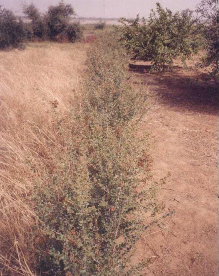
Grass strips slow down runoff, increase infiltration and retain sediment, thus increasing crop production.
2.2 技术的详细说明
说明:
Grass strips measuring 0.80 m to 1 m wide are planted 20 to 80 m apart on low-gradient terrain. Local grasses (for example, Andropogon gayanus, Cymbopogon schoenateus and Vetivera nigritiana) are sown or planted (plantlets) at the start of the rainy season. Like stone bunds, grass strips are planted along the natural contour of the land to slow down runoff, increase infiltration and retain sediment. Grass strips get bigger as sediment builds up, which maintains their capacity to retain water, unlike mechanical structures (stone bunds and dikes).
The species of grass are chosen according to what the farmers want to use them for (straw, hay, mat weaving, roofing, construction of straw granaries, brooms, etc.). In cattle and sheep raising areas, the use of fodder plants can increase interest in this technique and ensure wider acceptance. It is recommended that the development of grass strips be combined with assisted natural regeneration (woody species) or the planting of trees.
Designed as an erosion control measure, grass strips slow down runoff in the event of heavy rain. They distribute rainwater more evenly over the land and improve infiltration which is particularly important when there are dry spells in the rainy season. Sediment builds up behind the grass strips, thereby reducing the erosion of fertile soil layers. The roots of the plants bind the soil and hold it in place. Although the vegetation growing in the strips competes with the crops to some extent for water, the overall effect on yields is positive. Crops are also protected from wind erosion. Thanks to the vegetation cover they provide, grass strips contribute to lowering soil temperature.
Like contour stone bunds, grass strips reduce the harmful effects of heavy rain and violent downpours, events that are expected to increase as a result of climate change.
Compared with plots without grass strips, millet yields were 50 kg per hectare per year higher, and straw yields 125 kg higher on plots with grass strips. Yields can be substantially improved by combining grass strips with the application of organic fertiliser, mulch or pen manure. The best results, an average increase of 280 kg of millet grain per hectare (370 kg of straw per hectare), were achieved by combining them with mulching and pen manuring. Grass strips therefore improve yields of cereals and forage for livestock (straw and grass growing on the strips).
Increased crop output increases household food security and improves livestock feeding. The straw cut on the grass strips can also be used for other purposes (fencing and roofing). It is also a source of income, as traditional products made with straw, such as woven mats, can be sold.
Grass growth tends to be patchy, and resowing is required several times to fill in the gaps in the strip. In order to protect the grass strips from grazing animals during the first year, it is recommended that the area be monitored, which requires strict control over the village herds and flocks and those of nomadic livestock keepers.
Some grasses tend to invade crop fields. It is therefore important to control them by cutting them down before they flower and to tend the strips regularly, straightening and cutting back the edges.
Any dead plants in the grass strips must be regularly replaced. Grass strips are more likely to be maintained if they are economically profitable, for example, if they produce hay for livestock or their output can be sold as forage or construction material.
It is a technique designed mainly for cropland, but can also be used on rangeland, provided that the plants are protected when the grass strips are put in place. Grass strips are suitable for areas in the Sahel and the Sudan with rainfall ranging between 400 and 1,000 mm/year and gently sloping terrain (< 2%). Ecological units that benefit from the implementation of this measure include dune land, pediments and plains (highland pediments). Grass strips are particularly appropriate for non-stony land in areas with higher rainfall levels.
2.3 技术照片
媒体库
2.5 已应用该技术的、本评估所涵盖的国家/地区/地点
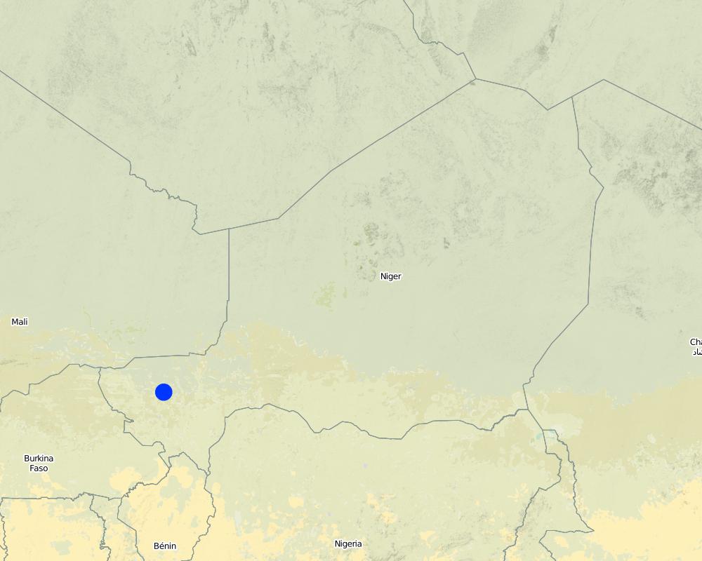
国家:
尼日尔
区域/州/省:
Niger
有关地点的进一步说明:
Filingué, Ouallam, Tillabéri, Tera
具体说明该技术的分布:
- 均匀地分布在一个区域
如果不知道精确的区域,请注明大致覆盖的区域:
- 10-100 平方千米
注释:
After three seasons of promoting this technique, grass strips had been established on a total area of 4674 hectares (sometimes in combination with other measures). Over half of the improved land is located in the Filingué area (2587 hectares), followed by Ouallam with 1042 hectares. However, only small areas were improved with grass strips in Tillabéri and Tera (228 hectares and 817 hectares respectively), where acceptance of this technique was low
Map
×2.6 实施日期
如果不知道确切的年份,请说明大概的日期:
- 10-50年前
2.7 技术介绍
详细说明该技术是如何引入的:
- 通过项目/外部干预
注释(项目类型等):
developed, implemented and disseminated as part of projects and programmes undertaken from the 1980s onwards to combat desertification and improve natural resource management. Implemented by GIZ (German Federal Enterprise for International Cooperation), PDRT (Projet de développement rural de Tahoua - Tahoua Rural Development Project), PASP (Projet de protection intégrée des ressources agro-sylvo-pastorales Tillabéri-Nord - Project for the Integrated Protection of Agricultural, Forest and Rangeland Resources in Tillabéri-Nord), and PATECORE (project for land development and resource conservation in Plateau Central Burkina Faso)
3. SLM技术的分类
3.1 该技术的主要目的
- 减少、预防、恢复土地退化
3.2 应用该技术的当前土地利用类型

农田
- 一年一作
每年的生长季节数:
- 1
具体说明:
Longest growing period in days: 120, Longest growing period from month to month: August to October

牧场
粗放式放牧:
- 半游牧畜牧业
集约放牧/饲料生产:
- 收割和携带/零放牧
注释:
Major land use problems (compiler’s opinion): soil erosion by water and wind, fertility decline
Livestock density: 1-10 LU /km2
3.4 供水
该技术所应用土地的供水:
- 雨养
3.5 该技术所属的SLM组
- 畜牧业和牧场管理
- 横坡措施
3.6 包含该技术的可持续土地管理措施

植物措施
- V1:乔木和灌木覆盖层
- V2:草和多年生草本植物
注释:
Type of vegetative measures: aligned: -contour
3.7 该技术强调的主要土地退化类型

土壤水蚀
- Wt:表土流失/地表侵蚀

土壤风蚀
- Et:表土流失

化学性土壤退化
- Cn:肥力下降和有机质含量下降(非侵蚀所致)

水质恶化
- Ha:干旱化
注释:
Main causes of degradation: soil management (Unadapted landuse methods, reduced or abandoned fallow periods), crop management (annual, perennial, tree/shrub) (Neglect of fallow periods and crop rotation), droughts (due to heat waves), population pressure (rapidly growing population increasing pressure on land), land tenure (insecure access to land and collectively managed communal land), poverty / wealth (very poor population)
Secondary causes of degradation: deforestation / removal of natural vegetation (incl. forest fires) (deforestation through overgrazing and fire wood collection), over-exploitation of vegetation for domestic use (firewood collection), overgrazing (cattle, sheep and goats), change in temperature (Climate change: heat waves), change of seasonal rainfall (more variable onset of rain), Heavy / extreme rainfall (intensity/amounts) (more variable and intensive rains), wind storms / dust storms (frequent storms), floods (due to intensive rain storms), labour availability (some migration of men to nearby cities), education, access to knowledge and support services (high level of illiteracy)
3.8 防止、减少或恢复土地退化
具体数量名该技术与土地退化有关的目标:
- 防止土地退化
- 减少土地退化
4. 技术规范、实施活动、投入和成本
4.1 该技术的技术图纸
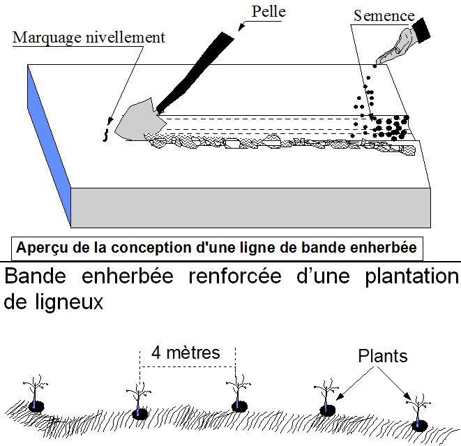
技术规范(与技术图纸相关):
Grass strips measuring 0.80 m to 1 m wide are planted 20 to 80 m apart on low-gradient terrain. Local grasses (for example, Andropogon gayanus, Cymbopogon schoenateus and Vetivera nigritiana) are sown or planted (plantlets) along the natural contour at the start of the rainy season.
Technical knowledge required for field staff / advisors: moderate
Technical knowledge required for land users: low
Main technical functions: control of dispersed runoff: retain / trap, control of dispersed runoff: impede / retard, control of concentrated runoff: retain / trap, control of concentrated runoff: impede / retard, improvement of ground cover, stabilisation of soil (eg by tree roots against land slides), increase in organic matter, increase in nutrient availability (supply, recycling,…), increase of infiltration, increase / maintain water stored in soil, water harvesting / increase water supply, sediment retention / trapping, sediment harvesting, reduction in wind speed, increase of biomass (quantity), promotion of vegetation species and varieties (quality, eg palatable fodder)
Secondary technical functions: increase of groundwater level / recharge of groundwater
Aligned: -contour
Vegetative material: T : trees / shrubs, G : grass
Number of plants per (ha): 200
Spacing between rows / strips / blocks (m): 20-80
Width within rows / strips / blocks (m): 0.8-1
Grass species: Andropogon gayanus, Cymbopogon schoenateus and Vetivera nigritiana
作者:
PASP
4.2 有关投入和成本计算的一般信息
其它/国家货币(具体说明):
CFA Franc
4.3 技术建立活动
| 活动 | 时间(季度) | |
|---|---|---|
| 1. | marking out the contour lines | |
| 2. | making 10-15 cm deep furrows in which to plant the seeds or seedlings | |
| 3. | sowing or planting 1 to 4 rows per strip. |
4.4 技术建立所需要的费用和投入
| 对投入进行具体说明 | 单位 | 数量 | 单位成本 | 每项投入的总成本 | 土地使用者承担的成本% | |
|---|---|---|---|---|---|---|
| 劳动力 | labour | ha | 1.0 | 46.7 | 46.7 | 100.0 |
| 植物材料 | seeds | ha | 1.0 | 3.3 | 3.3 | 100.0 |
| 技术建立所需总成本 | 50.0 | |||||
| 技术建立总成本,美元 | 50.0 | |||||
4.5 维护/经常性活动
| 活动 | 时间/频率 | |
|---|---|---|
| 1. | resowing is required several times. Any dead plants in the grass strips must be regularly replaced. | |
| 2. | Cutting down grasses which invade crop fields. | |
| 3. | straightening and cutting back the edges |
4.7 影响成本的最重要因素
描述影响成本的最决定性因素:
Labour: 6 man-days per ha
• marking out the contour lines
• making 10-15 cm deep furrows in which to plant the seeds or seedlings
• sowing or planting 1 to 4 rows per strip. Upkeep: 2.5 man-days per year.
Other costs:
• grass seeds or seedlings
• equipment: water-tube level.
5. 自然和人文环境
5.1 气候
年降雨量
- < 250毫米
- 251-500毫米
- 501-750毫米
- 751-1,000毫米
- 1,001-1,500毫米
- 1,501-2,000毫米
- 2,001-3,000毫米
- 3,001-4,000毫米
- > 4,000毫米
农业气候带
- 半干旱
Thermal climate class: subtropics
5.2 地形
平均坡度:
- 水平(0-2%)
- 缓降(3-5%)
- 平缓(6-10%)
- 滚坡(11-15%)
- 崎岖(16-30%)
- 陡峭(31-60%)
- 非常陡峭(>60%)
地形:
- 高原/平原
- 山脊
- 山坡
- 山地斜坡
- 麓坡
- 谷底
垂直分布带:
- 0-100 m a.s.l.
- 101-500 m a.s.l.
- 501-1,000 m a.s.l.
- 1,001-1,500 m a.s.l.
- 1,501-2,000 m a.s.l.
- 2,001-2,500 m a.s.l.
- 2,501-3,000 m a.s.l.
- 3,001-4,000 m a.s.l.
- > 4,000 m a.s.l.
5.3 土壤
平均土层深度:
- 非常浅(0-20厘米)
- 浅(21-50厘米)
- 中等深度(51-80厘米)
- 深(81-120厘米)
- 非常深(> 120厘米)
土壤质地(表土):
- 中粒(壤土、粉土)
- 细粒/重质(粘土)
表土有机质:
- 低(<1%)
5.4 水资源可用性和质量
地下水位表:
5-50米
地表水的可用性:
中等
水质(未处理):
仅供农业使用(灌溉)
5.5 生物多样性
物种多样性:
- 低
5.6 应用该技术的土地使用者的特征
生产系统的市场定位:
- 生计(自给)
非农收入:
- 收入的10-50%
相对财富水平:
- 非常贫瘠
- 贫瘠
机械化水平:
- 手工作业
- 畜力牵引
性别:
- 男人
说明土地使用者的其他有关特征:
Population density: 10-50 persons/km2
Annual population growth: 3% - 4% (mostly poor households below poverty line).
Off-farm income specification: men migrate temporarily or permanently to cities for off-farm income, women and men seasonally carry out paid farm work
5.7 应用该技术的土地使用者使用的平均土地面积
- < 0.5 公顷
- 0.5-1 公顷
- 1-2 公顷
- 2-5公顷
- 5-15公顷
- 15-50公顷
- 50-100公顷
- 100-500公顷
- 500-1,000公顷
- 1,000-10,000公顷
- > 10,000公顷
这被认为是小规模、中规模还是大规模的(参照当地实际情况)?:
- 小规模的
5.8 土地所有权、土地使用权和水使用权
土地所有权:
- 州
- 个人,未命名
土地使用权:
- 自由进入(无组织)
用水权:
- 自由进入(无组织)
注释:
traditional land use rights prevail. On fields individual land use rights, communal rights on pasture and forest land (collection of wood and other products (fruits, medicinal plants))
5.9 进入服务和基础设施的通道
健康:
- 贫瘠
- 适度的
- 好
教育:
- 贫瘠
- 适度的
- 好
技术援助:
- 贫瘠
- 适度的
- 好
就业(例如非农):
- 贫瘠
- 适度的
- 好
市场:
- 贫瘠
- 适度的
- 好
能源:
- 贫瘠
- 适度的
- 好
道路和交通:
- 贫瘠
- 适度的
- 好
饮用水和卫生设施:
- 贫瘠
- 适度的
- 好
金融服务:
- 贫瘠
- 适度的
- 好
6. 影响和结论性说明
6.1 该技术的现场影响
社会经济效应
生产
作物生产
饲料生产
畜牧生产
生产故障风险
生产区域
注释/具体说明:
Part of the plot is taken up by the grass strips, reducing the area left for growing crops
收入和成本
农业收入
收入来源的多样性
工作量
其它社会经济效应
competition of grasses with crops
社会文化影响
食品安全/自给自足
冲突缓解
contribution to human well-being
注释/具体说明:
Increased crop output increases household food security and improves livestock feeding. The straw cut on the grass strips can also be used for other purposes (fencing and roofing). It is also a source of income, as traditional products made with straw, such as woven mats, can be sold.
生态影响
水循环/径流
水的回收/收集
地表径流
土壤
土壤水分
土壤覆盖层
土壤流失
养分循环/补给
减少气候和灾害风险
风速
6.2 该技术的场外影响已经显现
下游洪水
下游淤积
风力搬运沉积物
6.3 技术对渐变气候以及与气候相关的极端情况/灾害的暴露和敏感性(土地使用者认为的极端情况/灾害)
渐变气候
渐变气候
| 季节 | 增加或减少 | 该技术是如何应对的? | |
|---|---|---|---|
| 年温度 | 增加 | 好 |
气候有关的极端情况(灾害)
气象灾害
| 该技术是如何应对的? | |
|---|---|
| 局地暴雨 | 好 |
| 局地风暴 | 好 |
气候灾害
| 该技术是如何应对的? | |
|---|---|
| 干旱 | 不好 |
水文灾害
| 该技术是如何应对的? | |
|---|---|
| 比较和缓的(河道)洪水 | 好 |
其他气候相关的后果
其他气候相关的后果
| 该技术是如何应对的? | |
|---|---|
| 缩短生长期 | 未知 |
6.4 成本效益分析
技术收益与技术建立成本相比如何(从土地使用者的角度看)?
短期回报:
稍微积极
长期回报:
稍微积极
技术收益与技术维护成本/经常性成本相比如何(从土地使用者的角度看)?
短期回报:
稍微积极
长期回报:
稍微积极
6.5 技术采用
注释:
In the Tillabéri area, in northern Niger, the adoption of grass strips varies greatly from one place to another. After three seasons of promoting this technique, grass strips had been established on a total area of 4,674 hectares (sometimes in combination with other measures). Over half of the improved land is located in the Filingué area (2,587 hectares), followed by Ouallam with 1,042 hectares.
However, only small areas were improved with grass strips in Tillabéri and Tera (228 hectares and 817 hectares respectively), where acceptance of this technique was low.
In spite of good results in terms of increased production and soil improvement, grass strips have only been widely accepted in southern Niger (Maradi and Zinder). Farmers are of the view that grass strips could be confused with plot boundaries.
The availability of land in southern Niger may be another factor that facilitates acceptance of the measure is this area. Part of the plot is taken up by the grass strips, reducing the area left for growing crops. This hinders acceptance in areas where land is limited. The reduced crop-growing area is offset by better per-hectare grain, straw and hay yields. Certain grasses (such as Andropogon gayanus) have a harmful effect on nearby crops. The systematic exploitation of the grass strips as a source of straw or hay improves acceptance of the technique. In the Tillabéri area, in Niger, the adoption of grass strips varies greatly from one place to another. After three seasons of promoting this technique, grass strips had been established on a total area of 4,674 hectares (sometimes in combination with other measures). Over half of the improved land is located in the Filingué area (2,587 hectares), followed by Ouallam with 1,042 hectares. However, only small areas were improved with grass strips in Tillabéri and Tera (228 hectares and 817 hectares respectively), where acceptance of this technique was low. In spite of good results in terms of increased production and soil improvement, grass strips have only been widely accepted in southern Niger (Maradi and Zinder). Farmers are of the view that grass strips could be confused with plot boundaries. The availability of land in southern Niger may be another factor that facilitates acceptance of the measure is this area. Part of the plot is taken up by the grass strips, reducing the area left for growing crops. This hinders acceptance in areas where land is limited. The reduced crop-growing area is offset by better per-hectare grain, straw and hay yields. Certain grasses (such as Andropogon gayanus) have a harmful effect on nearby crops. The systematic exploitation of the grass strips as a source of straw or hay improves acceptance of the technique. At first, people living in the areas covered by the PDRT project were reluctant to establish grass strips. They considered them to be weeds with no place on their farmland. With time and exchange visits within the country, they began to accept the technique.
6.7 该技术的优点/长处/机会
| 编制者或其他关键资源人员认为的长处/优势/机会 |
|---|
| reduce the harmful effects of heavy rain and violent downpours, events that are expected to increase as a result of climate change |
| improve rainwater harvesting and water retention in the soil |
| contribute to creating vegetation cover, which provides a habitat for biodiversity |
| contribute to lowering soil temperature and are also effective in reducing wind erosion. As the vegetation provides shelter from the wind, fine particles of soil accumulate behind the strips. |
| Increased crop output increases household food security and improves livestock feeding. The straw cut on the grass strips can also be used for other purposes (fencing and roofing). It is also a source of income, as traditional products made with straw, such as woven mats, can be sold. |
6.8 技术的弱点/缺点/风险及其克服方法
| 编制者或其他关键资源人员认为的弱点/缺点/风险 | 如何克服它们? |
|---|---|
| Grass growth tends to be patchy, and resowing is required several times to fill in the gaps in the strip. Strips with bare patches are not effective in retaining water, and rilling can be caused by water gushing through the gaps. | The clumps must therefore be arranged in staggered rows and the strips made wide enough to prevent this problem. |
| With the use of certain types of grasses that grow in clumps, such as Andropogon grass, gaps are left between the tufts, and water spurting through these gaps can cause rilling. | |
| In spite of good results in terms of increased production and soil improvement, grass strips have only been widely accepted in southern Niger (Maradi and Zinder). Farmers are of the view that grass strips could be confused with plot boundaries. | |
| Certain grasses (such as Andropogon gayanus) have a harmful effect on nearby crops. | |
| Part of the plot is taken up by the grass strips, reducing the area left for growing crops. This hinders acceptance in areas where land is limited. |
7. 参考和链接
7.1 信息的方法/来源
- 实地考察、实地调查
- 与土地使用者的访谈
(现场)数据是什么时候汇编的?:
01/07/2012
7.2 参考可用出版物
标题、作者、年份、ISBN:
Good Practices in Soil and Water Conservation. A contribution to adaptation and farmers´ resilience towards climate change in the Sahel. Published by GIZ in 2012.
可以从哪里获得?成本如何?
http://agriwaterpedia.info/wiki/Main_Page
链接和模块
全部展开 全部收起链接
无链接
模块
无模块