
Contour Tied Trench [阿富汗]
- 创建:
- 更新:
- 编制者: Aqila Haidery
- 编辑者: –
- 审查者: David Streiff, Alexandra Gavilano
Chuquorak (Dari)
technologies_1661 - 阿富汗
查看章节
全部展开 全部收起1. 一般信息
1.2 参与该技术评估和文件编制的资源人员和机构的联系方式
有助于对技术进行记录/评估的机构名称(如相关)
HELVETAS (Swiss Intercooperation)1.3 关于使用通过WOCAT记录的数据的条件
编制者和关键资源人员接受有关使用通过WOCAT记录数据的条件。:
是
2. SLM技术的说明
2.1 技术简介
技术定义:
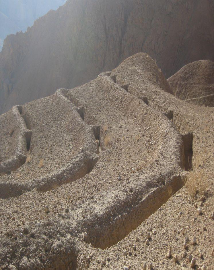
Trenches with soil bunds constructed in a tied manner along contour lines to trap surface runoff and sediments from degraded uplands
2.2 技术的详细说明
说明:
Contour Tied Trenches (CTT) were constructed to trap and retain surface runoff and sediments with the main objective of reducing flash flood risks from the Sou-rakhak watershed which was badly degraded due to overgrazing, excessive cutting of shrubs for fuel wood, rainfed cropping and recurring droughts. The technology was combined with other structural measures like soil bunds, check dams, water ponds, and plantation of fruit, non-fruit trees, fodder crops like alfalfa, Asafoetida and Cumin as cash crops. The watershed is also protected from grazing and shrub cutting by the participating communities. Community bakeries were constructed in the valleys and bio-briquette technology promoted for reducing shrub consump-tion/cutting.
Purpose of the Technology: Continuous Contour Trench (CCT) technology was applied to trap and retain surface runoff and sediments with the main objective of reducing flash flood risks from Sourakhak watershed and preventing damages due to flash floods in the valleys.
Establishment / maintenance activities and inputs: Feasibility studies were conducted and workers from three Community Develop-ment Councils (CDCs) of Roy-e Sang (Kahmard) implemented the construction works based on the technical proposals. The workers were organised by the Sourakhak watershed management committee and they got a daily wage of USD 5 for their labour inputs. About 670 families (276 person days/ha) participated in the construction of CTTs and other technologies.
One supervisor appointed by the communities and a watershed worker from HEL-VETAS Swiss Intercooperation side, both paid by the project, monitored the water-shed works with technical advice from the project staff. The work was carried out in phases and in 4 years (starting 2009) about 65,000 trenches were constructed. About 216 trenches were constructed per hectare and the construction cost was about 1450 USD/ha, which included 1380 USD for labour and 70 USD for tools. The International Swiss Re Award (2009), the Swiss Agency for Development and Cooperation (SDC), HELVETAS Swiss Intercooperation and the participating families financially contributed to the watershed management works.
Natural / human environment: Sourakhak watershed has a semi-arid and temperate climate. The area receives up to 400 mm rainfall (annually) and snow during winter time. The watershed elevation ranges from 2000-3000 m amsl and soil type is sandy-loam to clay type. The land users who applied thsi technology are mostly smallholders. The uplnad areas where the technology was applied is owned by the state, but local communities have long term land use rights.
Sourakhak watershed has a semi-arid and temperate climate. The area receives up to maximum 400 mm rainfall annually in a normal year and snow during winter. About 80% of the rain falls from March to June, with most rain falling in the months of April and May. The watershed is located at an elevation ranging from 2000-3000 m (amsl) and the soil is sandy-loam to clay type. The land users who applied the CTTs are mostly smallholders (with less than 1 ha irrigated land) and they reside in the valley bottoms. The upland areas, where the CTT have been constructed, belong to the state but the local communities have land and water use rights. From a climate change perspective, CTTs will not be much affected by temperature changes or drought. Some trenches could break if there is an extreme rainfall event.
2.3 技术照片
媒体库
2.5 已应用该技术的、本评估所涵盖的国家/地区/地点
国家:
阿富汗
区域/州/省:
Bamyan Province
有关地点的进一步说明:
Kahmard district
具体说明该技术的分布:
- 均匀地分布在一个区域
如果技术均匀分布在一个区域,则指定覆盖的区域(单位为平方千米):
3.0
如果不知道精确的区域,请注明大致覆盖的区域:
- 1-10 平方千米
注释:
Total area covered by the SLM Technology is 3 km2.
About 65,000 trenches each measuring 5 m in length x 0.7 m in depth and 0.7 m in width (in middle) were constructed manually.
2.6 实施日期
如果不知道确切的年份,请说明大概的日期:
- 不到10年前(最近)
2.7 技术介绍
详细说明该技术是如何引入的:
- 通过项目/外部干预
注释(项目类型等):
The project started in 2008.
3. SLM技术的分类
3.1 该技术的主要目的
- 减少、预防、恢复土地退化
- 降低灾害风险
3.2 应用该技术的当前土地利用类型

牧场
粗放式放牧:
- 半游牧畜牧业
注释:
Major land use problems (compiler’s opinion): Depleted soils, poor vegetative cover, deep gullies leading which trigger severe flash floods.
Major land use problems (land users’ perception): Severe flash floods from the degraded watershed.
Future (final) land use (after implementation of SLM Technology): Mixed: Mo: Other
Number of growing seasons per year: 1
Longest growing period in days: 180; Longest growing period from month to month: March to July
3.3 由于技术的实施,土地使用是否发生了变化?
牧场
- Extensive grazing
3.4 供水
该技术所应用土地的供水:
- 雨养
3.5 该技术所属的SLM组
- 区域封闭(停止使用,支持恢复)
- 横坡措施
- 引水和排水
3.6 包含该技术的可持续土地管理措施

结构措施
- S4:平沟、坑
3.7 该技术强调的主要土地退化类型

土壤水蚀
- Wt:表土流失/地表侵蚀
- Wo:场外劣化效应

生物性退化
- Bc:植被覆盖的减少
注释:
Secondary types of degradation addressed: Bc: reduction of vegetation cover
Main causes of degradation: over-exploitation of vegetation for domestic use (Shrubs used for fuel), overgrazing (Mainly by sheep and goats), governance / institutional (No management system either by the government or local communities)
Secondary causes of degradation: droughts (Slow recovery of natural vegetation), population pressure, war and conflicts (Cutting of Juniper trees)
3.8 防止、减少或恢复土地退化
具体数量名该技术与土地退化有关的目标:
- 修复/恢复严重退化的土地
4. 技术规范、实施活动、投入和成本
4.1 该技术的技术图纸
技术规范(与技术图纸相关):
Technical specifications of Contour Tied Trench with soil bunds constructed at Sourakhak wa-tershed. Fruit and non-fruit trees have been planted at a few selected sites in the watershed as vegetative measures. The plant survival per cent was about 10% due to drought, rodent problem and poor adaptation of the tree saplings brought from a different natural environment. The sites are protected from grazing and shrub cutting leading to better land cover.
The trenches have the capacity to store about 159,250 cu.m of water. Kahmard receives up to 350 mm rainfall per year. Considering catchment area of 3 km2 the trenches can hold all the water if there was 50 mm rain at a time, which is rare.Trench size: 5 m (L), 1m at top and 0.4 m at bottom (W), 0.7 m (D)
Distance between trench in a row = 0.3-0.7 m and spacing between contours = 4-8 m depending on the slope (steeper slopes have less distance)
Soil bund size: 5.5 m (L), 0.7 m/0.4 m (W), 0.5 m (H)
The trenches have the capacity to store about 159,250 cu.m of water. Kahmard receives up to 350 mm rainfall per year. Considering catchment area of 3 km2 the trenches can hold all the water if there was 50 mm rainfall at a time, which is rare.
Location: Afghanistan. Kahmard/Bamyan
Date: 12/12/2012
Technical knowledge required for field staff / advisors: high (Initial stages. It is a new technology for most field staff.)
Technical knowledge required for land users: high (Initial stages. Land users have to learn first where to apply, how to apply and maintain this technology and also the method for preparing contour lines.)
Main technical functions: control of dispersed runoff: retain / trap
Secondary technical functions: reduction of slope length, increase of infiltration
Retention/infiltration ditch/pit, sediment/sand trap
Spacing between structures (m): 4-8
Depth of ditches/pits/dams (m): 0.7
Width of ditches/pits/dams (m): 0.7
Length of ditches/pits/dams (m): 5
Height of bunds/banks/others (m): 0.5
Width of bunds/banks/others (m): 0.7
Length of bunds/banks/others (m): 5.5
作者:
Ahmad Ali Sediqi, HELVETAS Swiss Intercooperation
4.2 有关投入和成本计算的一般信息
具体说明成本计算所用货币:
- 美元
注明雇用劳工的每日平均工资成本:
5.00
4.3 技术建立活动
| 活动 | 时间(季度) | |
|---|---|---|
| 1. | construction of trenches | summer and autumn |
4.4 技术建立所需要的费用和投入
| 对投入进行具体说明 | 单位 | 数量 | 单位成本 | 每项投入的总成本 | 土地使用者承担的成本% | |
|---|---|---|---|---|---|---|
| 劳动力 | Construction of trenches | persons/day/ha | 276.0 | 5.0 | 1380.0 | 10.0 |
| 设备 | Tools | ha | 1.0 | 70.0 | 70.0 | 90.0 |
| 技术建立所需总成本 | 1450.0 | |||||
| 技术建立总成本,美元 | 1450.0 | |||||
注释:
Duration of establishment phase: 36 month(s)
4.5 维护/经常性活动
| 活动 | 时间/频率 | |
|---|---|---|
| 1. | Repair trenches | Spring/once per year |
4.6 维护/经常性活动所需要的费用和投入(每年)
| 对投入进行具体说明 | 单位 | 数量 | 单位成本 | 每项投入的总成本 | 土地使用者承担的成本% | |
|---|---|---|---|---|---|---|
| 劳动力 | Repair trenches | persons/day/ha | 1.0 | 5.0 | 5.0 | 100.0 |
| 技术维护所需总成本 | 5.0 | |||||
| 技术维护总成本,美元 | 5.0 | |||||
注释:
Machinery/ tools: Shovel
4.7 影响成本的最重要因素
描述影响成本的最决定性因素:
Labour
5. 自然和人文环境
5.1 气候
年降雨量
- < 250毫米
- 251-500毫米
- 501-750毫米
- 751-1,000毫米
- 1,001-1,500毫米
- 1,501-2,000毫米
- 2,001-3,000毫米
- 3,001-4,000毫米
- > 4,000毫米
农业气候带
- 半干旱
Thermal climate class: temperate
5.2 地形
平均坡度:
- 水平(0-2%)
- 缓降(3-5%)
- 平缓(6-10%)
- 滚坡(11-15%)
- 崎岖(16-30%)
- 陡峭(31-60%)
- 非常陡峭(>60%)
地形:
- 高原/平原
- 山脊
- 山坡
- 山地斜坡
- 麓坡
- 谷底
垂直分布带:
- 0-100 m a.s.l.
- 101-500 m a.s.l.
- 501-1,000 m a.s.l.
- 1,001-1,500 m a.s.l.
- 1,501-2,000 m a.s.l.
- 2,001-2,500 m a.s.l.
- 2,501-3,000 m a.s.l.
- 3,001-4,000 m a.s.l.
- > 4,000 m a.s.l.
5.3 土壤
平均土层深度:
- 非常浅(0-20厘米)
- 浅(21-50厘米)
- 中等深度(51-80厘米)
- 深(81-120厘米)
- 非常深(> 120厘米)
土壤质地(表土):
- 粗粒/轻(砂质)
- 细粒/重质(粘土)
表土有机质:
- 低(<1%)
如有可能,附上完整的土壤描述或具体说明可用的信息,例如土壤类型、土壤酸碱度、阳离子交换能力、氮、盐度等。:
Soil fertility is low - medium
Soil drainage / infiltration is medium - good
Soil water storage capacity is medium
5.4 水资源可用性和质量
地表水的可用性:
中等
水质(未处理):
不良饮用水(需要处理)
关于水质和水量的注释和进一步规范:
Availability of surface water: During rainy seasons
Water quality (untreated): Not good but used for animal drinking water using traditional water harvesting structures
5.5 生物多样性
物种多样性:
- 低
关于生物多样性的注释和进一步规范:
Gradually improving
5.6 应用该技术的土地使用者的特征
生产系统的市场定位:
- 混合(生计/商业)
非农收入:
- 收入的10-50%
个人或集体:
- 团体/社区
性别:
- 男人
说明土地使用者的其他有关特征:
Land users applying the Technology are mainly common / average land users
Difference in the involvement of women and men: Women are not allowed to work in these areas due to local customs.
Population density: 10-50 persons/km2
Annual population growth: 2% - 3%
Relative level of wealth: rich, average, poor
10% of the land users are rich.
40% of the land users are average wealthy.
50% of the land users are poor.
Market orientation of production system: Income from selling sheep and goats and items from livestotck products like carpets.
5.7 应用该技术的土地使用者使用的平均土地面积
- < 0.5 公顷
- 0.5-1 公顷
- 1-2 公顷
- 2-5公顷
- 5-15公顷
- 15-50公顷
- 50-100公顷
- 100-500公顷
- 500-1,000公顷
- 1,000-10,000公顷
- > 10,000公顷
这被认为是小规模、中规模还是大规模的(参照当地实际情况)?:
- 小规模的
5.8 土地所有权、土地使用权和水使用权
土地所有权:
- 州
土地使用权:
- 社区(有组织)
用水权:
- 社区(有组织)
注释:
Land is used by families of three community development councils in Kahmard district as common land
5.9 进入服务和基础设施的通道
健康:
- 贫瘠
- 适度的
- 好
教育:
- 贫瘠
- 适度的
- 好
技术援助:
- 贫瘠
- 适度的
- 好
就业(例如非农):
- 贫瘠
- 适度的
- 好
市场:
- 贫瘠
- 适度的
- 好
能源:
- 贫瘠
- 适度的
- 好
道路和交通:
- 贫瘠
- 适度的
- 好
饮用水和卫生设施:
- 贫瘠
- 适度的
- 好
金融服务:
- 贫瘠
- 适度的
- 好
6. 影响和结论性说明
6.1 该技术的现场影响
社会经济效应
生产
饲料生产
注释/具体说明:
Increase in natural production due to increased moisture and area protection
生产区域
注释/具体说明:
As the area is closed for grazing and shrub cutting
社会文化影响
社区机构
注释/具体说明:
Work is facilitated by watershed management committee
SLM/土地退化知识
livelihood and human well-being
注释/具体说明:
It has reduced flash flood risks. As a result, more area in the valleys is productive and damages to houses, roads, gardens, agriculture land have significantly reduced
生态影响
水循环/径流
水的回收/收集
地下水位/含水层
土壤
土壤水分
生物多样性:植被、动物
植物多样性
6.2 该技术的场外影响已经显现
下游洪水
对邻近农田的破坏
注释/具体说明:
Due to less flash floods
6.3 技术对渐变气候以及与气候相关的极端情况/灾害的暴露和敏感性(土地使用者认为的极端情况/灾害)
渐变气候
渐变气候
| 季节 | 增加或减少 | 该技术是如何应对的? | |
|---|---|---|---|
| 年温度 | 增加 | 好 |
气候有关的极端情况(灾害)
气象灾害
| 该技术是如何应对的? | |
|---|---|
| 局地暴雨 | 不好 |
气候灾害
| 该技术是如何应对的? | |
|---|---|
| 干旱 | 好 |
其他气候相关的后果
其他气候相关的后果
| 该技术是如何应对的? | |
|---|---|
| 缩短生长期 | 好 |
注释:
Stabilize CTTs with vegetative and management measures. Trench size should be based on hydro-meteorological parameters considering possibility of an extreme event occurring.
6.4 成本效益分析
技术收益与技术建立成本相比如何(从土地使用者的角度看)?
短期回报:
积极
长期回报:
非常积极
技术收益与技术维护成本/经常性成本相比如何(从土地使用者的角度看)?
短期回报:
积极
长期回报:
非常积极
6.5 技术采用
注释:
100% of land user families have adopted the Technology with external material support
6.7 该技术的优点/长处/机会
| 土地使用者眼中的长处/优势/机会 |
|---|
| Reduce flash floods risks |
|
Helps in spring recharge How can they be sustained / enhanced? CTTs should be maintained and combined with vegetation measures for better infiltration. |
| 编制者或其他关键资源人员认为的长处/优势/机会 |
|---|
|
Reduce flash floods risks How can they be sustained / enhanced? Maintenance and application of vegetative measures along with the trenches. For Instance planting of perennial forage species on the bunds like Alfalfa, Agropyron and Sainfoin.. |
|
CTTs considered better than staggered contour trench if the purpose is to control flash floods as it can trap more runoff and have less chances of damages How can they be sustained / enhanced? Maintenance and correct implementation is necessary |
|
Helps in the establishment of vegetation due to more soil moisture How can they be sustained / enhanced? Combine with conservation practices like mulching |
|
Potential technology for reducing flash flood risks How can they be sustained / enhanced? More training and awareness about the limitations of this technology - where to apply and where not to apply |
6.8 技术的弱点/缺点/风险及其克服方法
| 编制者或其他关键资源人员认为的弱点/缺点/风险 | 如何克服它们? |
|---|---|
| Soil disturbed during digging and fine clay deposits in the trenches which reduces infiltration | Apply conservation trenches. Planting on the either ends of the trench and soil working to break the clay layering. |
| Establishment costs are high | Initial external support necessary. Linking relief to sustainable land management could be an option. |
| Loss of land for production due to trenching | ntegrate planting of trees and grasses. |
| Trenches break | CTTs must be of right size along the contour lines. Workers must be trained before implementation work and there must be proper supervision. The size of a trench and spacing between trenches should be based on hydro-met parameters. Also, avoid steep sandy (blue) and shallow rocky soil beds |
7. 参考和链接
7.1 信息的方法/来源
链接和模块
全部展开 全部收起链接
无链接
模块
无模块