Water-spreading weirs for the development of degraded dry river valleys [Chad]
- Creation:
- Update:
- Compiler: Unknown User
- Editor: –
- Reviewer: Fabian Ottiger
Seuils d’épandage pour la valorisation des vallées d'oued dégradées
technologies_1536 - Chad
View sections
Expand all Collapse all1. General information
1.2 Contact details of resource persons and institutions involved in the assessment and documentation of the Technology
Key resource person(s)
SLM specialist:
Bender Heinz
Name of project which facilitated the documentation/ evaluation of the Technology (if relevant)
Book project: Water Harvesting – Guidelines to Good Practice (Water Harvesting)1.3 Conditions regarding the use of data documented through WOCAT
When were the data compiled (in the field)?
08/03/2012
The compiler and key resource person(s) accept the conditions regarding the use of data documented through WOCAT:
Ja
2. Description of the SLM Technology
2.1 Short description of the Technology
Definition of the Technology:
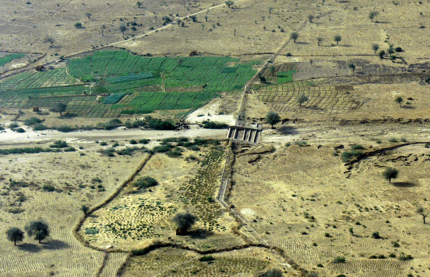
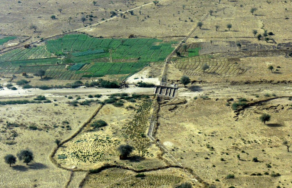
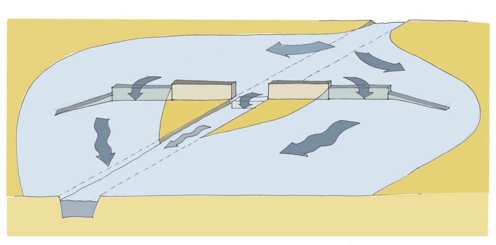
Water-spreading weirs are structures that span the entire width of a valley to spread floodwater over the adjacent land area.
2.2 Detailed description of the Technology
Description:
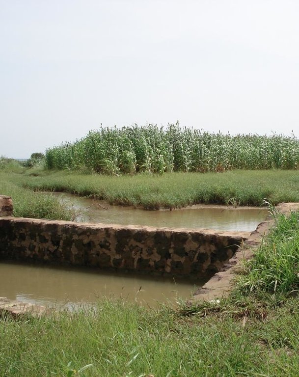
Over the last 12 years water-spreading weirs have been introduced and improved as a new rehabilitation technique for degraded dry valleys in Burkina Faso, Niger and Chad. In Chad 104 water-spreading weirs were constructed in the scope of the two development projects, initiated by the German Technical Cooperation (GIZ) and the Swiss Development Cooperation (SDC) in the 1990s. Water-spreading weirs are made of natural stones and cement, and consist of a spillway in the actual riverbed and lateral abutments and wings. Floodwaters are spread over the adjacent land area above the structure, where they eventually overflow the lateral wings and then slowly flow back towards the riverbed below the structure. As a result the land area below the weir is flooded. The lateral spreading of the water causes the land area above and below the structure to be flooded and supplies it with sediment. Water infiltrates, gullies in the valley are filled and the riverbed is raised. Thanks to the infiltration, the groundwater table also rises in a few years.
Purpose of the Technology: In dry valleys in which water flows in the rivers for only a few days a year, the weirs serve to distribute the incoming runoff over the valley floor and allow as much water as possible to infiltrate the soil. The aquifer is thus replenished and is then available for agricultural use. In contrast to the various types of dams, the goal of water-spreading weirs is not to create reservoirs for later use. What water-spreading weirs do is cause a temporary flooding of the adjacent land area above and below the weir. Depending on user preferences, the primary goal may be 1) agricultural use, 2) sylvo-pastoral use or 3) the replenishment and rising of the water table.
Establishment / maintenance activities and inputs: Water-spreading weirs require detailed technical planning and experienced engineering and construction firms. The bulk of the work is performed using local materials and by village craftsmen and helpers.
Natural / human environment: Compared to small impoundment dams, retention basins and microweirs, water-spreading weirs are especially well-suited for shallow, wide valleys that, due to severe gully erosion, are no longer inundated by small and medium
volume floodwaters. The flooding no longer takes place because the actual riverbed has been deeply eroded and enlarged. However, water-spreading weirs are also suitable for improving agricultural productivity in more or less intact valley floors. Water-spreading weirs are successful in regions where precipitation during the growing season is erratic and where the weirs ensure a more evenly distributed water supply for crops, as well as in zones in which water enrichment makes one or two additional growing seasons possible. At the present time they are in use in a broad area where annual rainfall ranges from 50 to 1,200 mm/year.
2.3 Photos of the Technology
2.5 Country/ region/ locations where the Technology has been applied and which are covered by this assessment
Country:
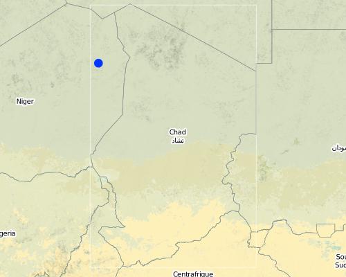
Chad
Region/ State/ Province:
Eastern Chad
Map
×2.6 Date of implementation
If precise year is not known, indicate approximate date:
- 10-50 years ago
2.7 Introduction of the Technology
Specify how the Technology was introduced:
- through projects/ external interventions
Comments (type of project, etc.):
The first water-spreading weirs were introduced during the 1990s in Chad through Swiss cooperation
3. Classification of the SLM Technology
3.1 Main purpose(s) of the Technology
- improve production
- reduce, prevent, restore land degradation
3.2 Current land use type(s) where the Technology is applied

Cropland
- Annual cropping
Main crops (cash and food crops):
Major cash crop: Onions, tomatoes, garlic
Major food crop: Millet, sorghum and cowpea
Other crops: Watermelon, okra, sesame

Grazing land
Extensive grazing land:
- Semi-nomadism/ pastoralism
Main animal species and products:
Sheep, goat, cow, dromedary
Comments:
Major land use problems (compiler’s opinion): Substantial degradation of drainage basins in the Sahel due to population growth and intense land-use pressure has been observed since the 1960s. Climate change has further amplified this trend. The expansion of agriculture and intensification of grazing and logging have caused the natural vegetation cover to decline. This process has been accelerated by severe droughts and has led to the degradation of the soils. Sparse vegetation cover and structurally damaged soils reduce rainfall infiltration into the soil, resulting in more runoff and soil erosion on plateaus and slopes. Runoff is concentrated in the valleys, in which heavy floodwaters
wash away fertile soils and lead to deep erosion of the riverbed. The annual, recurrent small and medium-size floods that normally cause temporary inundation of the valleys and deposition of fertile sediments no longer occur.
3.3 Further information about land use
other (e.g. post-flooding):
- Post-flooding
Comments:
Water supply: Also mixed rainfed - irrigated and rainfed
3.4 SLM group to which the Technology belongs
- cross-slope measure
- irrigation management (incl. water supply, drainage)
- water diversion and drainage
3.5 Spread of the Technology
Specify the spread of the Technology:
- evenly spread over an area
If the Technology is evenly spread over an area, indicate approximate area covered:
- 10-100 km2
Comments:
Total area covered by the SLM Technology is 20 m2.
The technology has been applied in 22 different valleys in Eastern Chad. The total area that profits from the installation of one such structure is therefore somewhere between 10 and 100 ha.
3.6 SLM measures comprising the Technology

structural measures
- S6: Walls, barriers, palisades, fences
3.7 Main types of land degradation addressed by the Technology

soil erosion by water
- Wt: loss of topsoil/ surface erosion
- Wg: gully erosion/ gullying

water degradation
- Hg: change in groundwater/aquifer level
Comments:
Main type of degradation addressed: Wt: loss of topsoil / surface erosion, Wg: gully erosion / gullying, Hg: change in groundwater / aquifer level
Main causes of degradation: soil management (abandonment of fallow periods), deforestation / removal of natural vegetation (incl. forest fires) (for agricultural expansion), over-exploitation of vegetation for domestic use, droughts, population pressure
Secondary causes of degradation: overgrazing
3.8 Prevention, reduction, or restoration of land degradation
Specify the goal of the Technology with regard to land degradation:
- reduce land degradation
- restore/ rehabilitate severely degraded land
Comments:
Main goals: rehabilitation / reclamation of denuded land
Secondary goals: mitigation / reduction of land degradation
4. Technical specifications, implementation activities, inputs, and costs
4.1 Technical drawing of the Technology
4.2 Technical specifications/ explanations of technical drawing
Water-spreading weir with spillway, lateral abutments and wing walls.
Technical knowledge required for field staff / advisors: high
Main technical functions: control of dispersed runoff: retain / trap, control of dispersed runoff: impede / retard, increase of groundwater level / recharge of groundwater, water harvesting / increase water supply, water spreading, sediment retention / trapping, sediment harvesting
Secondary technical functions: increase of infiltration, spatial arrangement and diversification of land use
Dam/ pan/ pond
Height of bunds/banks/others (m): 0.75
Width of bunds/banks/others (m): 5
Length of bunds/banks/others (m): 500
4.4 Establishment activities
| Activity | Type of measure | Timing | |
|---|---|---|---|
| 1. | Excavating the steps | Structural | |
| 2. | Excavating the wall foundations | Structural | |
| 3. | Pouring the foundations | Structural | |
| 4. | Building the walls | Structural | |
| 5. | Finishing the walls and filling the stilling basin | Structural |
4.5 Costs and inputs needed for establishment
| Specify input | Unit | Quantity | Costs per Unit | Total costs per input | % of costs borne by land users | |
|---|---|---|---|---|---|---|
| Labour | Labour | ha | 1.0 | 750.0 | 750.0 | 100.0 |
| Equipment | Total costs for equipment | ha | 1.0 | 750.0 | 750.0 | |
| Construction material | Stone | ha | 1.0 | 750.0 | 750.0 | |
| Total costs for establishment of the Technology | 2250.0 | |||||
4.7 Costs and inputs needed for maintenance/ recurrent activities (per year)
| Specify input | Unit | Quantity | Costs per Unit | Total costs per input | % of costs borne by land users | |
|---|---|---|---|---|---|---|
| Labour | Labour | ha | 1.0 | 50.0 | 50.0 | 100.0 |
| Equipment | Total costs for equipment | ha | 1.0 | 50.0 | 50.0 | |
| Construction material | Stone | ha | 1.0 | 50.0 | 50.0 | |
| Total costs for maintenance of the Technology | 150.0 | |||||
Comments:
The costs were calculated per structure (one diversion weir). The length of the weir varies depending on the width of the valley it is constructed in. The weir has to span the whole valley which is usually between 100 and 1000 m wide.
5. Natural and human environment
5.1 Climate
Annual rainfall
- < 250 mm
- 251-500 mm
- 501-750 mm
- 751-1,000 mm
- 1,001-1,500 mm
- 1,501-2,000 mm
- 2,001-3,000 mm
- 3,001-4,000 mm
- > 4,000 mm
Specifications/ comments on rainfall:
251-500 mm Ranked 1
<250 mm Ranked 2
150-400 mm / year
Agro-climatic zone
- semi-arid
Thermal climate class: tropics
5.2 Topography
Slopes on average:
- flat (0-2%)
- gentle (3-5%)
- moderate (6-10%)
- rolling (11-15%)
- hilly (16-30%)
- steep (31-60%)
- very steep (>60%)
Landforms:
- plateau/plains
- ridges
- mountain slopes
- hill slopes
- footslopes
- valley floors
Altitudinal zone:
- 0-100 m a.s.l.
- 101-500 m a.s.l.
- 501-1,000 m a.s.l.
- 1,001-1,500 m a.s.l.
- 1,501-2,000 m a.s.l.
- 2,001-2,500 m a.s.l.
- 2,501-3,000 m a.s.l.
- 3,001-4,000 m a.s.l.
- > 4,000 m a.s.l.
5.3 Soils
Soil depth on average:
- very shallow (0-20 cm)
- shallow (21-50 cm)
- moderately deep (51-80 cm)
- deep (81-120 cm)
- very deep (> 120 cm)
Soil texture (topsoil):
- fine/ heavy (clay)
Topsoil organic matter:
- high (>3%)
- medium (1-3%)
If available, attach full soil description or specify the available information, e.g. soil type, soil PH/ acidity, Cation Exchange Capacity, nitrogen, salinity etc.
Soil fertility: High
Soil drainage/infiltration: Medium (ranked 1) and good (ranked 2)
Soil water storage capacity: Medium
5.4 Water availability and quality
Ground water table:
5-50 m
Availability of surface water:
poor/ none
Water quality (untreated):
good drinking water
Comments and further specifications on water quality and quantity:
Availability of surface water: excess (during heavy rainfalls in the rainy season) or poor/ none (in the dry season)
5.5 Biodiversity
Species diversity:
- medium
5.6 Characteristics of land users applying the Technology
Market orientation of production system:
- mixed (subsistence/ commercial
Off-farm income:
- less than 10% of all income
Relative level of wealth:
- poor
Individuals or groups:
- groups/ community
Indicate other relevant characteristics of the land users:
Population density: < 10 persons/km2
70% of the land users are poor.
Market orientation: Mixed (rainfed crops are for subsistence, post-rainy season crops and irrigated crops (vegetables) mainly for market)
5.7 Average area of land owned or leased by land users applying the Technology
- < 0.5 ha
- 0.5-1 ha
- 1-2 ha
- 2-5 ha
- 5-15 ha
- 15-50 ha
- 50-100 ha
- 100-500 ha
- 500-1,000 ha
- 1,000-10,000 ha
- > 10,000 ha
5.8 Land ownership, land use rights, and water use rights
Land ownership:
- communal/ village
Land use rights:
- leased
Comments:
In Chad, only the rainfed fields are in private family ownership and inheritable. Reclaimed irrigated fields and vegetable production fields go back to the community and can be redistributed.
6. Impacts and concluding statements
6.1 On-site impacts the Technology has shown
Socio-economic impacts
Production
crop production
Quantity before SLM:
158 kg/ha
Quantity after SLM:
653 kg/ha
Comments/ specify:
Increase of millet yield in Chad
fodder production
fodder quality
animal production
Quantity before SLM:
6,000 cattle head
Quantity after SLM:
16,000 cattle heads
Comments/ specify:
The increase in groundwater level has led to a significant increase in the number of cattle heads that can be watered
risk of production failure
product diversity
production area
Quantity before SLM:
2.85 ha
Quantity after SLM:
5.29 ha
Comments/ specify:
The numbers are from a study on water-spreading weirs in Niger, but for Chad the situation is comparable
Income and costs
farm income
Comments/ specify:
Users of water-spreading weirs had 112% higher incomes compared to farmers outside the impact zone from sales of vegetables and surplus grain
workload
Comments/ specify:
The workload of women is eased thanks to the availability of and easier access to water due to the shallower water table
Other socio-economic impacts
Income for the community
Comments/ specify:
Temporary income was generated for the local workers during the weir construction. About 231 Euros per user family.
Socio-cultural impacts
food security/ self-sufficiency
Comments/ specify:
Food security assured through crop and livestock farming
health situation
Comments/ specify:
Children have a healthier, more diverse diet due to the vegetable production and the introduction of new crops
community institutions
Comments/ specify:
The weirs are becoming an element of interaction and social integration for the inhabitants of surrounding villages
SLM/ land degradation knowledge
Comments/ specify:
Through training
conflict mitigation
Comments/ specify:
Decline in conflicts between farmers and livestock raisers over water rights owing to the fact that sufficient water is now available
situation of socially and economically disadvantaged groups
Comments/ specify:
Temporary emigration to Sudan and Lybia has declined and in some villages people who had long since emigrated returned home
Diversification and creation of activities
Comments/ specify:
In the vicinity of the weirs activities such as trading of agricultural products, fishing, watering livestock and making clay tiles have emerged
Training for weir construction
Comments/ specify:
Numerous local masons were trained
Improved planning skills
Comments/ specify:
Village people, service providers, communal representatives, government technical sectors have improved their skills in organisation, planning and implementation
Poverty
Poverty
Ecological impacts
Water cycle/ runoff
water quantity
harvesting/ collection of water
Comments/ specify:
More and longer-lasting bodies of surface water
surface runoff
groundwater table/ aquifer
Comments/ specify:
In some communities groundwater has risen to a depth of 6m below surface
Soil
soil moisture
soil loss
Comments/ specify:
Gullies are filled in
nutrient cycling/ recharge
Comments/ specify:
Deposition of nutrients
soil organic matter/ below ground C
Comments/ specify:
Deposition of organic matter
Biodiversity: vegetation, animals
biomass/ above ground C
Comments/ specify:
Spread of natural vegetation around the rehabilitated valley plains
plant diversity
Comments/ specify:
Vanished plant species return
animal diversity
Comments/ specify:
Vanished animal species return
habitat diversity
6.2 Off-site impacts the Technology has shown
water availability
downstream flooding
downstream siltation
buffering/ filtering capacity
6.3 Exposure and sensitivity of the Technology to gradual climate change and climate-related extremes/ disasters (as perceived by land users)
Gradual climate change
Gradual climate change
| Season | Type of climatic change/ extreme | How does the Technology cope with it? | |
|---|---|---|---|
| annual temperature | increase | well |
Climate-related extremes (disasters)
Meteorological disasters
| How does the Technology cope with it? | |
|---|---|
| local rainstorm | well |
| local windstorm | well |
Hydrological disasters
| How does the Technology cope with it? | |
|---|---|
| general (river) flood | well |
6.4 Cost-benefit analysis
How do the benefits compare with the establishment costs (from land users’ perspective)?
Short-term returns:
negative
Long-term returns:
very positive
How do the benefits compare with the maintenance/ recurrent costs (from land users' perspective)?
Short-term returns:
slightly positive
Long-term returns:
very positive
Comments:
Depending upon the users' experience and the availability of labour, it may take anywhere from 2 to 10 years before the rehabilitated land area reaches its optimum use potential.
6.5 Adoption of the Technology
Of all those who have adopted the Technology, how many have did so spontaneously, i.e. without receiving any material incentives/ payments?
- 0-10%
Comments:
100% of land user families have adopted the Technology with external material support
6000 land user families have adopted the Technology with external material support
Comments on acceptance with external material support: Between 4000 and 8000 households are direct beneficiaries of the construction of water-spreading weirs in Eastern Chad.
There is no trend towards spontaneous adoption of the Technology
Comments on adoption trend: It is unlikely that communities will be able to adopt this technology without external funding. Even for maintenance activities it remains to be seen if the communities will be capable of funding more extensive maintenance work with their low budgets.
6.7 Strengths/ advantages/ opportunities of the Technology
| Strengths/ advantages/ opportunities in the compiler’s or other key resource person’s view |
|---|
|
Through the construction of water-spreading weirs, soils are regularly flooded and supplied with water and sediment. Thus, the arable land area and the yields of the rainy season crops serving as staple food increase. How can they be sustained / enhanced? Ensure proper maintenance of the system. |
| The more frequent flooding of the soils results in increased infiltration, and the groundwater level rises substantially. |
|
Prior to rehabilitation, in most of the sites, it was only possible to grow a rainfed crop and perhaps an irrigated crop on some small areas of land. After, in addition to the rainfed crop grown on larger areas of land, it became possible to grow a post-rainy season crop (culture de contresaison) and, once the water table had risen, an irrigated crop (culture de décrue) as well. How can they be sustained / enhanced? Upscale water-spreading weirs to increase the number of people benefitting. |
|
Post-rainy season crops and irrigated crops diversify agricultural production. They are used as a means of earning cash income. How can they be sustained / enhanced? Improve access to markets. |
| With their capacity to regulate annual floodwaters and harness them to stabilise production, water-spreading weirs are an effective measure for adapting to climate change in regions experiencing increasing variability in rainfall. |
6.8 Weaknesses/ disadvantages/ risks of the Technology and ways of overcoming them
| Weaknesses/ disadvantages/ risks in the compiler’s or other key resource person’s view | How can they be overcome? |
|---|---|
| It can be assumed that one third of the weirs will require complete renovation every 20 years | The renovation of these weirs can be done for approximately 10% of the initial construction costs |
| Maintenance of the weirs by the management committees is still a weak area. Funds expected from user fees for the plots are often inadequately collected and too low to cover costs. Some management committees lose their drive and neglect their duties. | New fundings sources have to be found and tapped. |
| In spite of the great potential for the use of water-spreading weirs and the very promising results, implementation will continue to depend in the medium term on outside funding, as it is unlikely that the communal budgets will be able to fund investments of this size. | The existing knowledge hast to be spread. |
| Know-how and experience for the construction of water-spreading weirs are still concentrated among a few countries. |
7. References and links
7.2 References to available publications
Title, author, year, ISBN:
Deutsche Gesellschaft für Internationale Zusammenarbeit (GIZ) (2011). Water-spreading weirs for the development of degraded dry river valleys. Experience from the Sahel. Frankfurt and Eschborn, GIZ and KFW.
Available from where? Costs?
http://www.gtz.de/de/dokumente/giz2012-en-water-spreading-weirs-sahel.pdf
Title, author, year, ISBN:
Direction du développement et de la coopération DDC (2012). Gestion des eaux de ruissellement dans le Tchad sahélien. Bern, DDC.
Available from where? Costs?
http://www.gopa.de/uploads/tx_bdojobopps/PRODOC_Tchad.pdf
Links and modules
Expand all Collapse allLinks
No links
Modules
No modules


