Water-spreading weirs for the development of degraded dry river valleys [ເຈດ]
- ການສ້າງ:
- ປັບປູງ:
- ຜູ້ສັງລວມຂໍ້ມູນ: Unknown User
- ບັນນາທິການ: –
- ຜູ້ທົບທວນຄືນ: Fabian Ottiger
Seuils d’épandage pour la valorisation des vallées d'oued dégradées
technologies_1536 - ເຈດ
ເບິ່ງພາກສ່ວນ
ຂະຫຍາຍທັງໝົດ ຍຸບທັງໝົດ1. ຂໍ້ມູນທົ່ວໄປ
1.2 ຂໍ້ມູນ ການຕິດຕໍ່ພົວພັນ ຂອງບຸກຄົນທີ່ສໍາຄັນ ແລະ ສະຖາບັນ ທີ່ມີສ່ວນຮ່ວມ ໃນການປະເມີນເອກກະສານ ເຕັກໂນໂລຢີ
ບັນດາຜູ້ຕອບແບບສອບຖາມທີ່ສໍາຄັນ ()
ຜຸ້ຊ່ຽວຊານ ດ້ານການຄຸ້ມຄອງ ທີ່ດິນແບບຍືນຍົງ:
Bender Heinz
ຊື່ໂຄງການ ທີ່ອໍານວຍຄວາມສະດວກ ໃນການສ້າງເອກກະສານ/ປະເມີນ ເຕັກໂນໂລຢີ (ຖ້າກ່ຽວຂ້ອງ)
Book project: Water Harvesting – Guidelines to Good Practice (Water Harvesting)1.3 ເງື່ອນໄຂ ກ່ຽວກັບ ການນໍາໃຊ້ຂໍ້ມູນເອກະສານ ທີ່ສ້າງຂື້ນ ໂດຍຜ່ານ ອົງການພາບລວມຂອງໂລກ ທາງດ້ານແນວທາງ ແລະ ເຕັກໂນໂລຢີ ຂອງການອານຸລັກ ທໍາມະຊາດ (WOCAT)
ເມື່ອໃດທີ່ໄດ້ສັງລວມຂໍ້ມູນ (ຢູ່ພາກສະໜາມ)?
08/03/2012
ຜູ້ປ້ອນຂໍ້ມູນ ແລະ ບຸກຄົນສຳຄັນ ທີ່ໃຫ້ຂໍ້ມູນ (ຫຼາຍ) ຍິນຍອມ ຕາມເງື່ອນໄຂ ໃນການນຳໃຊ້ຂໍ້ມູນ ເພື່ອສ້າງເປັນເອກກະສານຂອງ WOCAT:
ແມ່ນ
2. ການອະທິບາຍ ເຕັກໂນໂລຢີ ຂອງການຄຸ້ມຄອງ ທີ່ດິນແບບຍືນຍົງ
2.1 ຄໍາອະທິບາຍສັ້ນຂອງ ເຕັກໂນໂລຢີ
ການກຳໜົດຄວາມໝາຍ ຂອງເຕັກໂນໂລຢີ:
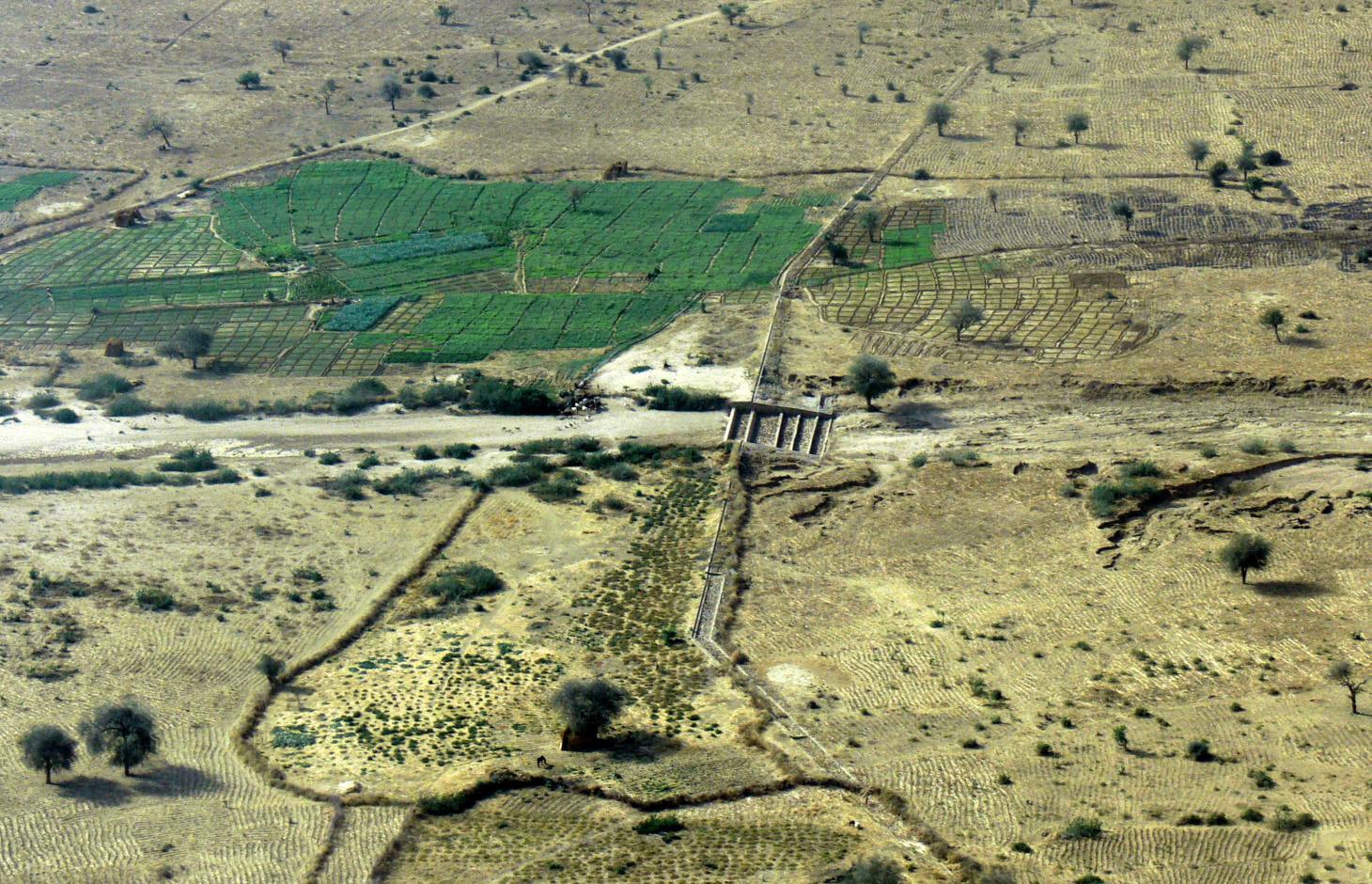
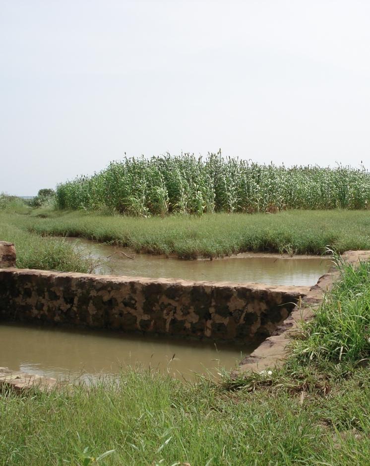
Water-spreading weirs are structures that span the entire width of a valley to spread floodwater over the adjacent land area.
2.2 ການອະທິບາຍ ລາຍລະອຽດ ຂອງເຕັກໂນໂລຢີ
ການພັນລະນາ:
Over the last 12 years water-spreading weirs have been introduced and improved as a new rehabilitation technique for degraded dry valleys in Burkina Faso, Niger and Chad. In Chad 104 water-spreading weirs were constructed in the scope of the two development projects, initiated by the German Technical Cooperation (GIZ) and the Swiss Development Cooperation (SDC) in the 1990s. Water-spreading weirs are made of natural stones and cement, and consist of a spillway in the actual riverbed and lateral abutments and wings. Floodwaters are spread over the adjacent land area above the structure, where they eventually overflow the lateral wings and then slowly flow back towards the riverbed below the structure. As a result the land area below the weir is flooded. The lateral spreading of the water causes the land area above and below the structure to be flooded and supplies it with sediment. Water infiltrates, gullies in the valley are filled and the riverbed is raised. Thanks to the infiltration, the groundwater table also rises in a few years.
Purpose of the Technology: In dry valleys in which water flows in the rivers for only a few days a year, the weirs serve to distribute the incoming runoff over the valley floor and allow as much water as possible to infiltrate the soil. The aquifer is thus replenished and is then available for agricultural use. In contrast to the various types of dams, the goal of water-spreading weirs is not to create reservoirs for later use. What water-spreading weirs do is cause a temporary flooding of the adjacent land area above and below the weir. Depending on user preferences, the primary goal may be 1) agricultural use, 2) sylvo-pastoral use or 3) the replenishment and rising of the water table.
Establishment / maintenance activities and inputs: Water-spreading weirs require detailed technical planning and experienced engineering and construction firms. The bulk of the work is performed using local materials and by village craftsmen and helpers.
Natural / human environment: Compared to small impoundment dams, retention basins and microweirs, water-spreading weirs are especially well-suited for shallow, wide valleys that, due to severe gully erosion, are no longer inundated by small and medium
volume floodwaters. The flooding no longer takes place because the actual riverbed has been deeply eroded and enlarged. However, water-spreading weirs are also suitable for improving agricultural productivity in more or less intact valley floors. Water-spreading weirs are successful in regions where precipitation during the growing season is erratic and where the weirs ensure a more evenly distributed water supply for crops, as well as in zones in which water enrichment makes one or two additional growing seasons possible. At the present time they are in use in a broad area where annual rainfall ranges from 50 to 1,200 mm/year.
2.3 ຮູບພາບຂອງເຕັກໂນໂລຢີ
ສື່ຮູບພາບ
2.5 ປະເທດ / ເຂດ / ສະຖານທີ່ບ່ອນທີ່ ເຕັກໂນໂລຢີ ໄດ້ຮັບການນໍາໃຊ້ ແລະ ທີ່ຖືກປົກຄຸມດ້ວຍການປະເມີນຜົນ
ປະເທດ:
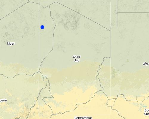
ເຈດ
ພາກພື້ນ / ລັດ / ແຂວງ:
Eastern Chad
Map
×2.6 ວັນທີໃນການຈັດຕັ້ງປະຕິບັດ
ຖ້າຫາກວ່າ ບໍ່ຮູ້ຈັກ ປີທີ່ຊັດເຈນ ແມ່ນໃຫ້ປະມານ ວັນທີເອົາ:
- 10-50 ປີ ຜ່ານມາ
2.7 ການນໍາສະເໜີ ເຕັກໂນໂລຢີ
ໃຫ້ລະບຸ ເຕັກໂນໂລຢີ ໄດ້ຖືກຈັດຕັ້ງປະຕິບັດຄືແນວໃດ?
- ໂດຍຜ່ານໂຄງການ / ການຊ່ວຍເຫຼືອຈາກພາຍນອກ
ຄວາມຄິດເຫັນ (ປະເພດ ໂຄງການ ແລະ ອື່ນໆ):
The first water-spreading weirs were introduced during the 1990s in Chad through Swiss cooperation
3. ການໃຈ້ແຍກ ເຕັກໂນໂລຢີ ໃນການຄຸ້ມຄອງ ດິນແບບຍືນຍົງ
3.1 ຈຸດປະສົງຫຼັກ (ຫຼາຍ) ຂອງເຕັກໂນໂລຢີ
- ປັບປຸງ ການຜະລິດ
- ຫຼຸດຜ່ອນ, ປ້ອງກັນ, ຟື້ນຟູ ການເຊື່ອມໂຊມຂອງດິນ
3.2 ປະເພດການນໍາໃຊ້ທີ່ດິນ ໃນປະຈຸບັນ() ທີ່ເຕັກໂນໂລຢີ ໄດ້ຖືກນໍາໃຊ້

ດິນທີ່ປູກພືດ
- ການປູກພືດປະຈໍາປີ
ການປູກພືດຫຼັກ (ທີ່ສາມາດສ້າງລັບຮັບ ເປັນເງິນສົດ ແລະ ເປັນພືດສະບຽງອາຫານ):
Major cash crop: Onions, tomatoes, garlic
Major food crop: Millet, sorghum and cowpea
Other crops: Watermelon, okra, sesame

ທົ່ງຫຍ້າລ້ຽງສັດ
ທົ່ງຫຍ້າລ້ຽງສັດທໍາມະຊາດ:
- ແບບເຄິ່ງຂັງ / ເຄິ່ງປ່ອຍ
ຊະນິດພັນສັດຕົ້ນຕໍ ແລະ ຜະລິດຕະພັນ:
Sheep, goat, cow, dromedary
ຄວາມຄິດເຫັນ:
Major land use problems (compiler’s opinion): Substantial degradation of drainage basins in the Sahel due to population growth and intense land-use pressure has been observed since the 1960s. Climate change has further amplified this trend. The expansion of agriculture and intensification of grazing and logging have caused the natural vegetation cover to decline. This process has been accelerated by severe droughts and has led to the degradation of the soils. Sparse vegetation cover and structurally damaged soils reduce rainfall infiltration into the soil, resulting in more runoff and soil erosion on plateaus and slopes. Runoff is concentrated in the valleys, in which heavy floodwaters
wash away fertile soils and lead to deep erosion of the riverbed. The annual, recurrent small and medium-size floods that normally cause temporary inundation of the valleys and deposition of fertile sediments no longer occur.
3.3 ຂໍ້ມູນເພີ່ມເຕີມກ່ຽວກັບການນໍາໃຊ້ທີ່ດິນ
ອື່ນໆ (ຕົວຢ່າງ, ຫຼັງຈາກນໍ້າຖ້ວມ):
- Post-flooding
ຄວາມຄິດເຫັນ:
Water supply: Also mixed rainfed - irrigated and rainfed
3.4 ການນໍາໃຊ້ເຕັກໂນໂລຢີ ທີ່ຢູ່ໃນກຸ່ມການຄຸ້ມຄອງ ທີ່ດິນແບບຍືນຍົງ
- ມາດຕະການ ຕັດຂວາງ ກັບຄວາມຄ້ອຍຊັນ
- ການຄຸ້ມຄອງຊົນລະປະທານ (ການສະໜອງນໍ້າ, ລະບາຍ)
- ຄວາມຫຼາກຫຼາຍຂອງນໍ້າ ແລະ ການລະບາຍ
3.5 ການຂະຫຍາຍເຕັກໂນໂລຢີ
ໃຫ້ລະບຸ ການແຜ່ຂະຫຍາຍ ເຕັກໂນໂລຢີ:
- ແຜ່ຂະຫຍາຍຢ່າງໄວວາໃນພື້ນທີ່
ຖ້າຫາກວ່າ ເຕັກໂນໂລຢີ ໄດ້ແຜ່ຂະຫຍາຍທົ່ວພື້ນທີ່ືື ຢ່າງສະໜ່ຳສະເໝີ, ໃຫ້ລະບຸ ເນື້ອທີ່ ໂດຍການຄາດຄະເນ:
- 10-100 ກມ 2
ຄວາມຄິດເຫັນ:
Total area covered by the SLM Technology is 20 m2.
The technology has been applied in 22 different valleys in Eastern Chad. The total area that profits from the installation of one such structure is therefore somewhere between 10 and 100 ha.
3.6 ມາດຕະການ ການຄຸ້ມຄອງ ທີ່ດິນແບບຍືນຍົງ ປະກອບດ້ວຍ ເຕັກໂນໂລຢີ

ມາດຕະການໂຄງສ້າງ
- S6: ແລວກັນເຈື່ອນ, ຮົ້ວ
3.7 ປະເພດດິນເຊື່ອມໂຊມ ຫຼັກທີ່ໄດ້ນໍາໃຊ້ ເຕັກໂນໂລຢີ

ດິນເຊາະເຈື່ອນ ໂດຍນໍ້າ
- Wt: ການສູນເສຍຊັ້ນໜ້າດິນ / ການເຊາະເຈື່ອນຜິວໜ້າດິນ
- Wg: ການເຊາະເຈື່ອນຮ່ອງນ້ຳ / ຫ້ວຍ

ການເຊື່ອມໂຊມ ຂອງນໍ້າ
- Hg: ການປ່ຽນແປງ ລະດັບນ້ຳໃຕ້ດິນ ຫຼື ນ້ຳບາດານ
ຄວາມຄິດເຫັນ:
Main type of degradation addressed: Wt: loss of topsoil / surface erosion, Wg: gully erosion / gullying, Hg: change in groundwater / aquifer level
Main causes of degradation: soil management (abandonment of fallow periods), deforestation / removal of natural vegetation (incl. forest fires) (for agricultural expansion), over-exploitation of vegetation for domestic use, droughts, population pressure
Secondary causes of degradation: overgrazing
3.8 ການປ້ອງກັນ, ການຫຼຸດຜ່ອນ, ຫຼືການຟື້ນຟູຂອງການເຊື່ອມໂຊມຂອງດິນ
ໃຫ້ລະບຸ ເປົ້າໝາຍ ເຕັກໂນໂລຢີ ທີ່ພົວພັນ ກັບຄວາມເຊື່ອມໂຊມຂອງດິນ:
- ຫຼຸດຜ່ອນການເຊື່ອມໂຊມຂອງດິນ
- ການຟື້ນຟູ / ຟື້ນຟູດິນທີ່ຊຸດໂຊມ
ຄວາມຄິດເຫັນ:
Main goals: rehabilitation / reclamation of denuded land
Secondary goals: mitigation / reduction of land degradation
4. ຂໍ້ກໍາໜົດ, ກິດຈະກໍາການປະຕິບັດ, ວັດຖຸດິບ, ແລະຄ່າໃຊ້ຈ່າຍ
4.1 ເຕັກນິກ ໃນການແຕ້ມແຜນວາດ ເຕັກໂນໂລຢີ
ຜູ້ຂຽນ:
Heinz Bender
4.2 ການແຕ້ມແຜນວາດອະທິບາຍເຕັກນິກ
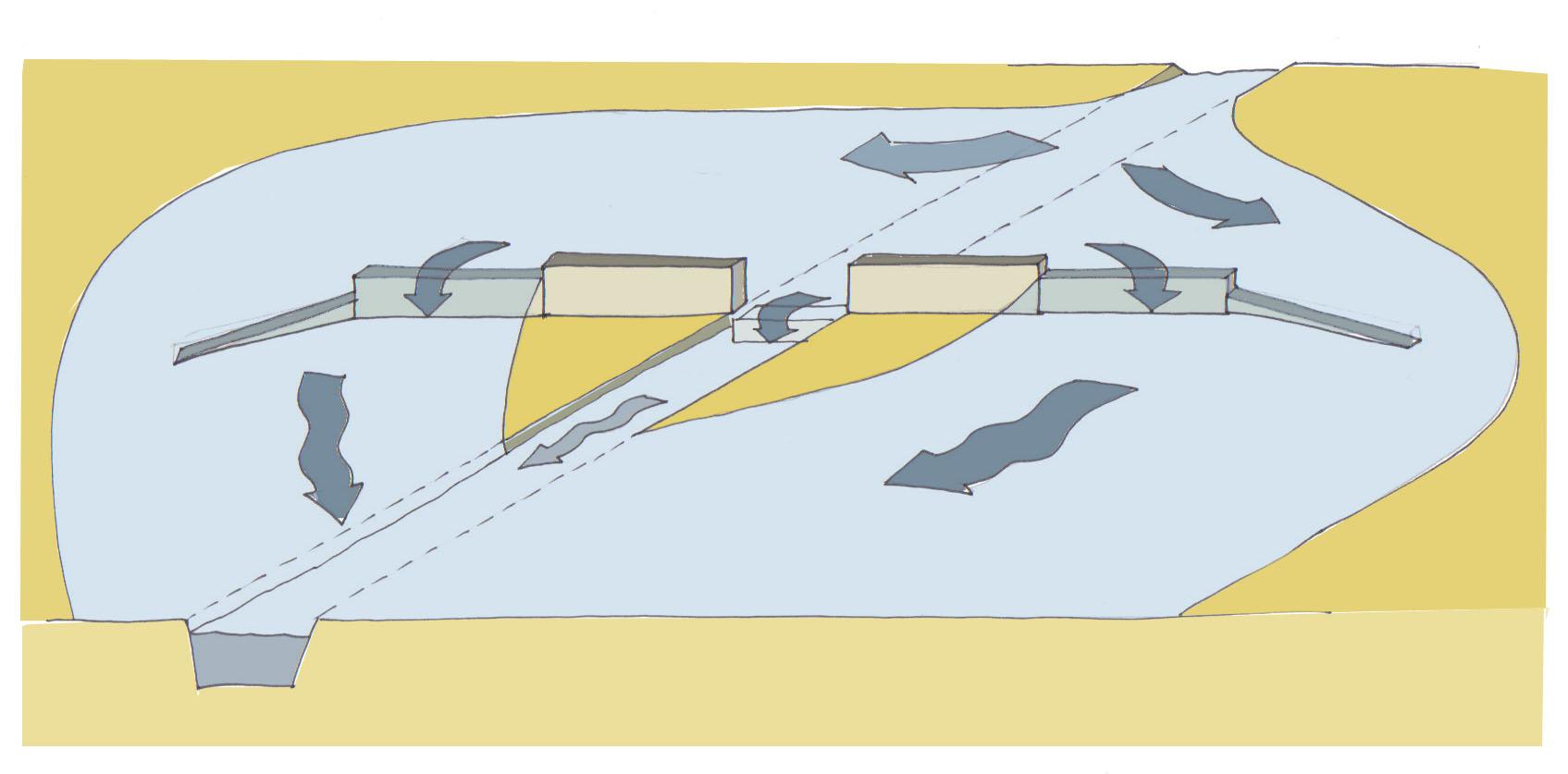
Water-spreading weir with spillway, lateral abutments and wing walls.
Technical knowledge required for field staff / advisors: high
Main technical functions: control of dispersed runoff: retain / trap, control of dispersed runoff: impede / retard, increase of groundwater level / recharge of groundwater, water harvesting / increase water supply, water spreading, sediment retention / trapping, sediment harvesting
Secondary technical functions: increase of infiltration, spatial arrangement and diversification of land use
Dam/ pan/ pond
Height of bunds/banks/others (m): 0.75
Width of bunds/banks/others (m): 5
Length of bunds/banks/others (m): 500
4.4 ການສ້າງຕັ້ງກິດຈະກໍາ
| ກິດຈະກໍາ | ປະເພດ ມາດຕະການ | ໄລຍະເວລາ | |
|---|---|---|---|
| 1. | Excavating the steps | ໂຄງສ້າງ | |
| 2. | Excavating the wall foundations | ໂຄງສ້າງ | |
| 3. | Pouring the foundations | ໂຄງສ້າງ | |
| 4. | Building the walls | ໂຄງສ້າງ | |
| 5. | Finishing the walls and filling the stilling basin | ໂຄງສ້າງ |
4.5 ຕົ້ນທຶນ ແລະ ປັດໄຈຂາເຂົ້າທີ່ຈໍາເປັນໃນຈັດຕັ້ງປະຕິບັດ
| ລະບຸ ປັດໃຈ ນໍາເຂົ້າ ໃນການຜະລີດ | ຫົວໜ່ວຍ | ປະລິມານ | ຕົ້ນທຶນ ຕໍ່ຫົວໜ່ວຍ | ຕົ້ນທຶນທັງໝົດ ຂອງປັດໃຈຂາເຂົ້າ ໃນການຜະລິດ | % ຂອງຕົ້ນທຶນທັງໝົດ ທີ່ຜູ້ນໍາໃຊ້ທີ່ດິນ ໃຊ້ຈ່າຍເອງ | |
|---|---|---|---|---|---|---|
| ແຮງງານ | Labour | ha | 1.0 | 750.0 | 750.0 | 100.0 |
| ອຸປະກອນ | Total costs for equipment | ha | 1.0 | 750.0 | 750.0 | |
| ວັດສະດຸກໍ່ສ້າງ | Stone | ha | 1.0 | 750.0 | 750.0 | |
| ຕົ້ນທຶນທັງໝົດ ໃນການຈັດຕັ້ງປະຕິບັດ ເຕັກໂນໂລຢີ | 2250.0 | |||||
4.7 ຄ່າໃຊ້ຈ່າຍ ແລະ ປັດໄຈນໍາເຂົ້າທີ່ຈໍາເປັນສໍາລັບການບໍາລຸງຮັກສາກິດຈະກໍາ / ແຜນປະຕິບັດ (ຕໍ່ປີ)
| ລະບຸ ປັດໃຈ ນໍາເຂົ້າ ໃນການຜະລີດ | ຫົວໜ່ວຍ | ປະລິມານ | ຕົ້ນທຶນ ຕໍ່ຫົວໜ່ວຍ | ຕົ້ນທຶນທັງໝົດ ຂອງປັດໃຈຂາເຂົ້າ ໃນການຜະລິດ | % ຂອງຕົ້ນທຶນທັງໝົດ ທີ່ຜູ້ນໍາໃຊ້ທີ່ດິນ ໃຊ້ຈ່າຍເອງ | |
|---|---|---|---|---|---|---|
| ແຮງງານ | Labour | ha | 1.0 | 50.0 | 50.0 | 100.0 |
| ອຸປະກອນ | Total costs for equipment | ha | 1.0 | 50.0 | 50.0 | |
| ວັດສະດຸກໍ່ສ້າງ | Stone | ha | 1.0 | 50.0 | 50.0 | |
| ຕົ້ນທຶນທັງໝົດ ທີ່ໃຊ້ໃນການບໍາລຸງຮັກສາ ເຕັກໂນໂລຢີ | 150.0 | |||||
ຄວາມຄິດເຫັນ:
The costs were calculated per structure (one diversion weir). The length of the weir varies depending on the width of the valley it is constructed in. The weir has to span the whole valley which is usually between 100 and 1000 m wide.
5. ສະພາບແວດລ້ອມທໍາມະຊາດ ແລະ ມະນຸດ
5.1 ອາກາດ
ປະລິມານນໍ້າຝົນປະຈໍາປີ
- < 250 ມີລິແມັດ
- 251-500 ມີລິແມັດ
- 501-750 ມີລິແມັດ
- 751-1,000 ມີລິແມັດ
- 1,001-1,500 ມີລິແມັດ
- 1,501-2,000 ມີລິແມັດ
- 2,001-3,000 ມີລິແມັດ
- 3,001-4,000 ມີລິແມັດ
- > 4,000 ມີລິແມັດ
ຂໍ້ມູນສະເພາະ / ຄວາມເຫັນກ່ຽວກັບ ປະລິມານນໍ້າຝົນ:
251-500 mm Ranked 1
<250 mm Ranked 2
150-400 mm / year
ເຂດສະພາບອາກາດກະສິກໍາ
- ເຄິ່ງແຫ້ງແລ້ງ
Thermal climate class: tropics
5.2 ພູມິປະເທດ
ຄ່າສະເລ່ຍ ຄວາມຄ້ອຍຊັນ:
- ພື້ນທີ່ຮາບພຽງ (0-2%)
- ອ່ອນ (3-5 %)
- ປານກາງ (6-10 %)
- ມ້ວນ (11-15 %)
- ເນີນ(16-30%)
- ໍຊັນ (31-60%)
- ຊັນຫຼາຍ (>60%)
ຮູບແບບຂອງດິນ:
- ພູພຽງ / ທົ່ງພຽງ
- ສັນພູ
- ເປີ້ນພູ
- ເນີນພູ
- ຕີນພູ
- ຮ່ອມພູ
ເຂດລະດັບສູງ:
- 0-100 ແມັດ a.s.l.
- 101-500 ແມັດ a.s.l.
- 501-1,000 ແມັດ a.s.l.
- 1,001-1,500 ແມັດ a.s.l.
- 1,501-2,000 ແມັດ a.s.l.
- 2,001-2,500 ແມັດ a.s.l.
- 2,501-3,000 ແມັດ a.s.l.
- 3,001-4,000 ແມັດ a.s.l.
- > 4,000 ແມັດ a.s.l.
5.3 ດິນ
ຄວາມເລິກ ຂອງດິນສະເລ່ຍ:
- ຕື້ນຫຼາຍ (0-20 ຊັງຕີແມັດ)
- ຕື້ນ (21-50 ຊຕມ)
- ເລີກປານກາງ (51-80 ຊຕມ)
- ເລິກ (81-120 ຊມ)
- ເລິກຫຼາຍ (> 120 cm)
ເນື້ອດິນ (ໜ້າດິນ):
- ບາງລະອຽດ / ໜັກ (ໜຽວ)
ຊັ້ນອິນຊີວັດຖຸ ເທິງໜ້າດິນ:
- ສູງ (> 3 %)
- ປານກາງ (1-3 %)
ຖ້າເປັນໄປໄດ້ ແມ່ນໃຫ້ຕິດຄັດ ການພັນລະນາດິນ ຫຼື ຂໍ້ມູນສະເພາະຂອງດິນ, ຕົວຢ່າງ, ຄຸນລັກສະນະ ປະເພດຂອງດິນ, ຄ່າຄວາມເປັນກົດ / ເປັນດ່າງຂອງດິນ, ສານອາຫານ, ດິນເຄັມ ແລະ ອື່ນໆ.
Soil fertility: High
Soil drainage/infiltration: Medium (ranked 1) and good (ranked 2)
Soil water storage capacity: Medium
5.4 ມີນໍ້າ ແລະ ຄຸນນະພາບ
ລະດັບ ນໍ້າໃຕ້ດິນ:
5-50 ແມັດ
ການມີນໍ້າ ເທິງໜ້າດິນ:
ທຸກຍາກ / ບໍ່ມີ
ຄຸນນະພາບນໍ້າ (ບໍ່ມີການບໍາບັດ):
ມີນໍ້າດື່ມ
ຄວາມຄິດເຫັນ ແລະ ຂໍ້ກໍານົດ ເພີ່ມເຕີມ ກ່ຽວກັບ ຄຸນນະພາບ ແລະ ປະລິມານ ຂອງນ້ຳ:
Availability of surface water: excess (during heavy rainfalls in the rainy season) or poor/ none (in the dry season)
5.5 ຊີວະນາໆພັນ
ຄວາມຫຼາກຫຼາຍ ທາງສາຍພັນ:
- ປານກາງ
5.6 ຄຸນລັກສະນະ ຂອງຜູ້ນໍາໃຊ້ທີ່ດິນ ທີ່ໄດ້ນໍາໃຊ້ເຕັກໂນໂລຢີ
ລະບົບ ການຕະຫຼາດ ແລະ ຜົນຜະລິດ:
- ປະສົມ (ກຸ້ມຕົນເອງ / ເປັນສິນຄ້າ
ລາຍຮັບ ທີ່ບໍ່ໄດ້ມາຈາກ ການຜະລິດ ກະສິກໍາ:
- ໜ້ອຍກ່ວາ 10 % ຂອງລາຍຮັບທັງໝົດ
ລະດັບຄວາມຮັ່ງມີ:
- ທຸກຍາກ
ບຸກຄົນ ຫຼື ກຸ່ມ:
- ກຸ່ມ / ຊຸມຊົນ
ໃຫ້ລະບຸ ຄຸນລັກສະນະ ຂອງຜູ້ນໍາໃຊ້ທີ່ດິນ:
Population density: < 10 persons/km2
70% of the land users are poor.
Market orientation: Mixed (rainfed crops are for subsistence, post-rainy season crops and irrigated crops (vegetables) mainly for market)
5.7 ພື້ນທີ່ສະເລ່ຍຂອງທີ່ດິນ ຫຼື ເຊົ່າໂດຍຜູ້ໃຊ້ທີ່ດິນການນໍາໃຊ້ ເຕັກໂນໂລຢີ
- <0.5 ເຮັກຕາ
- 0.5-1 ເຮັກຕາ
- 1-2 ເຮັກຕາ
- 2-5 ເຮັກຕາ
- 5-15 ເຮັກຕາ
- 15-50 ເຮັກຕາ
- 50-100 ເຮັກຕາ
- 100-500 ເຮັກຕາ
- 500-1,000 ເຮັກຕາ
- 1,000-10,000 ເຮັກຕາ
- > 10,000 ເຮັກຕາ
5.8 ເຈົ້າຂອງທີ່ດິນ, ສິດໃຊ້ທີ່ດິນ, ແລະ ສິດທິການນໍາໃຊ້ນໍ້າ
ເຈົ້າຂອງດິນ:
- ຊຸມຊົນ / ບ້ານ
ສິດທິ ໃນການນໍາໃຊ້ທີ່ດິນ:
- ເຊົ່າ
ຄວາມຄິດເຫັນ:
In Chad, only the rainfed fields are in private family ownership and inheritable. Reclaimed irrigated fields and vegetable production fields go back to the community and can be redistributed.
6. ຜົນກະທົບ ແລະ ລາຍງານສະຫຼຸບ
6.1 ການສະແດງຜົນກະທົບ ພາຍໃນພື້ນທີ່ ທີ່ໄດ້ຈັດຕັ້ງປະຕິບັດ ເຕັກໂນໂລຢີ
ຜົນກະທົບທາງເສດຖະກິດສັງຄົມ
ການຜະລິດ
ການຜະລິດພືດ
ປະລິມານ ກ່ອນການຈັດຕັ້ງປະຕິບັດ ການຄຸ້ມຄອງ ທີ່ດິນແບບຍືນຍົງ:
158 kg/ha
ປະລີມານ ຫຼັງການຈັດຕັ້ງປະຕິບັດ ການຄຸ້ມຄອງ ທີ່ດິນແບບຍືນຍົງ:
653 kg/ha
ຄວາມຄິດເຫັນ / ລະບຸແຈ້ງ:
Increase of millet yield in Chad
ການຜະລິດອາຫານສັດ
ຄຸນນະພາບຂອງອາຫານສັດ
ຜົນຜະລິດຂອງສັດ
ປະລິມານ ກ່ອນການຈັດຕັ້ງປະຕິບັດ ການຄຸ້ມຄອງ ທີ່ດິນແບບຍືນຍົງ:
6,000 cattle head
ປະລີມານ ຫຼັງການຈັດຕັ້ງປະຕິບັດ ການຄຸ້ມຄອງ ທີ່ດິນແບບຍືນຍົງ:
16,000 cattle heads
ຄວາມຄິດເຫັນ / ລະບຸແຈ້ງ:
The increase in groundwater level has led to a significant increase in the number of cattle heads that can be watered
ຄວາມສ່ຽງ ຕໍ່ຜົນຜະລິດ
ຄວາມໜາແໜ້ນ ຂອງຜົນຜະລິດ
ເນື້ອທີ່ການຜະລິດ
ປະລິມານ ກ່ອນການຈັດຕັ້ງປະຕິບັດ ການຄຸ້ມຄອງ ທີ່ດິນແບບຍືນຍົງ:
2.85 ha
ປະລີມານ ຫຼັງການຈັດຕັ້ງປະຕິບັດ ການຄຸ້ມຄອງ ທີ່ດິນແບບຍືນຍົງ:
5.29 ha
ຄວາມຄິດເຫັນ / ລະບຸແຈ້ງ:
The numbers are from a study on water-spreading weirs in Niger, but for Chad the situation is comparable
ລາຍໄດ້ ແລະ ຄ່າໃຊ້ຈ່າຍ
ລາຍຮັບ ຈາກການຜະລີດ
ຄວາມຄິດເຫັນ / ລະບຸແຈ້ງ:
Users of water-spreading weirs had 112% higher incomes compared to farmers outside the impact zone from sales of vegetables and surplus grain
ມີວຽກໜັກ
ຄວາມຄິດເຫັນ / ລະບຸແຈ້ງ:
The workload of women is eased thanks to the availability of and easier access to water due to the shallower water table
ຜົນກະທົບທາງດ້ານເສດຖະກິດສັງຄົມອື່ນໆ
Income for the community
ຄວາມຄິດເຫັນ / ລະບຸແຈ້ງ:
Temporary income was generated for the local workers during the weir construction. About 231 Euros per user family.
ຜົນກະທົບດ້ານວັດທະນາທໍາສັງຄົມ
ການຄໍ້າປະກັນ ສະບຽງອາຫານ / ກຸ້ມຢູ່ກຸ້ມກິນ
ຄວາມຄິດເຫັນ / ລະບຸແຈ້ງ:
Food security assured through crop and livestock farming
ສະພາບທາງດ້ານສຸຂະພາບ
ຄວາມຄິດເຫັນ / ລະບຸແຈ້ງ:
Children have a healthier, more diverse diet due to the vegetable production and the introduction of new crops
ສະຖາບັນ ການຈັດຕັ້ງຊຸມຊົນ
ຄວາມຄິດເຫັນ / ລະບຸແຈ້ງ:
The weirs are becoming an element of interaction and social integration for the inhabitants of surrounding villages
ຄວາມຮູ້ກ່ຽວກັບ ການຄຸ້ມຄອງ ທີ່ດິນແບບຍືນຍົງ / ການເຊື່ອມໂຊມຂອງດິນ
ຄວາມຄິດເຫັນ / ລະບຸແຈ້ງ:
Through training
ການຫຼຸດຜ່ອນ ຂໍ້ຂັດແຍ່ງ
ຄວາມຄິດເຫັນ / ລະບຸແຈ້ງ:
Decline in conflicts between farmers and livestock raisers over water rights owing to the fact that sufficient water is now available
ສະຖານະການຂອງສັງຄົມ ແລະ ກຸ່ມດ້ອຍໂອກາດທາງເສດຖະກິດ
ຄວາມຄິດເຫັນ / ລະບຸແຈ້ງ:
Temporary emigration to Sudan and Lybia has declined and in some villages people who had long since emigrated returned home
Diversification and creation of activities
ຄວາມຄິດເຫັນ / ລະບຸແຈ້ງ:
In the vicinity of the weirs activities such as trading of agricultural products, fishing, watering livestock and making clay tiles have emerged
Training for weir construction
ຄວາມຄິດເຫັນ / ລະບຸແຈ້ງ:
Numerous local masons were trained
Improved planning skills
ຄວາມຄິດເຫັນ / ລະບຸແຈ້ງ:
Village people, service providers, communal representatives, government technical sectors have improved their skills in organisation, planning and implementation
Poverty
Poverty
ຜົນກະທົບຕໍ່ລະບົບນິເວດ
ວົງຈອນນໍ້າ / ນໍ້າ
ປະລິມານນໍ້າ
ການຂຸດຄົ້ນ / ການເກັບກັກນໍ້າ
ຄວາມຄິດເຫັນ / ລະບຸແຈ້ງ:
More and longer-lasting bodies of surface water
ການໄຫຼ ຂອງນໍ້າໜ້າດິນ
ຊັ້ນນໍ້າໄຕ້ດິນ / ນໍ້າ
ຄວາມຄິດເຫັນ / ລະບຸແຈ້ງ:
In some communities groundwater has risen to a depth of 6m below surface
ດິນ
ຄວາມຊຸ່ມຂອງດິນ
ການສູນເສຍດິນ
ຄວາມຄິດເຫັນ / ລະບຸແຈ້ງ:
Gullies are filled in
ວົງຈອນ ຂອງສານອາຫານໃນດິນ
ຄວາມຄິດເຫັນ / ລະບຸແຈ້ງ:
Deposition of nutrients
ອິນຊີວັດຖຸໃນດິນ / ຢູ່ລຸ່ມຊັ້ນດິນ C
ຄວາມຄິດເຫັນ / ລະບຸແຈ້ງ:
Deposition of organic matter
ຊີວະນານາພັນ: ສັດ, ພືດ
ມວນຊີວະພາບ / ຢູ່ເທິງຊັ້ນດິນ C
ຄວາມຄິດເຫັນ / ລະບຸແຈ້ງ:
Spread of natural vegetation around the rehabilitated valley plains
ຄວາມຫຼາກຫຼາຍຂອງພືດ
ຄວາມຄິດເຫັນ / ລະບຸແຈ້ງ:
Vanished plant species return
ຄວາມຫຼາກຫຼາຍຂອງສັດ
ຄວາມຄິດເຫັນ / ລະບຸແຈ້ງ:
Vanished animal species return
ຄວາມຫຼາກຫຼາຍ ທາງດ້ານທີ່ຢູ່ອາໃສ ຂອງສິ່ງທີ່ມີຊີວິດ
6.2 ຜົນກະທົບທາງອ້ອມ ຈາກການນໍາໃຊ້ເຕັກໂນໂລຢີ
ສາມາດເຂົ້າເຖິງແຫຼ່ງນໍ້າ
ນໍ້າຖ້ວມຢູ່ເຂດລຸ່ມນໍ້າ
ການທັບຖົມ ຂອງດິນຕະກອນ ຢູ່ເຂດລຸ່ມນໍ້າ
ການປ້ອງກັນ / ຄວາມອາດສາມາດ ການກັ່ນຕອງ
6.3 ການປ້ອງກັນ ແລະ ຄວາມບອບບາງ ຂອງເຕັກໂນໂລຢິ ໃນການປ່ຽນແປງສະພາບດິນຟ້າອາກາດ ແລະ ກ່ຽວຂ້ອງກັບອາກາດທີ່ມີການປ່ຽນແປງທີ່ຮຸນແຮງ / ໄພພິບັດທາງທໍາມະຊາດ (ຮັບຮູ້ໄດ້ໂດຍຜູ້ນໍາໃຊ້ທີ່ດິນ)
ການປ່ຽນແປງດິນຟ້າອາກາດ ເທື່ອລະກ້າວ
ການປ່ຽນແປງດິນຟ້າອາກາດ ເທື່ອລະກ້າວ
| ລະດູການ | ຮູບແບບ ການປ່ຽນແປງດິນຟ້າອາກາດ / ທີ່ຮ້າຍແຮງ | ການນໍາໃຊ້ ເຕັກໂນໂລຢີ ສາມາດ ຮັບມື ໄດ້ຄືແນວໃດ? | |
|---|---|---|---|
| ອຸນຫະພູມປະຈໍາປີ | ເພີ່ມຂື້ນ | ດີ |
ອາກາດ ທີ່ກ່ຽວພັນກັບຄວາມຮຸນແຮງ (ໄພພິບັດທາງທໍາມະຊາດ)
ໄພພິບັດທາງອຸຕຸນິຍົມ
| ການນໍາໃຊ້ ເຕັກໂນໂລຢີ ສາມາດ ຮັບມື ໄດ້ຄືແນວໃດ? | |
|---|---|
| ພະຍຸຝົນ | ດີ |
| ພາຍຸລົມທ້ອງຖິ່ນ | ດີ |
ໄພພິບັດທາງອຸທົກກະສາກ
| ການນໍາໃຊ້ ເຕັກໂນໂລຢີ ສາມາດ ຮັບມື ໄດ້ຄືແນວໃດ? | |
|---|---|
| ໂດຍທົ່ວໄປ (ແມ່ນໍ້າ) ນໍ້າຖ້ວມ | ດີ |
6.4 ການວິເຄາະຕົ້ນທຶນ ແລະ ຜົນປະໂຫຍດ
ຈະເຮັດປະໂຫຍດເພື່ອປຽບທຽບກັບຄ່າໃຊ້ຈ່າຍກັບສິ່ງກໍ່ສ້າງ (ຈາກທັດສະນະຂອງຜູ້ນຳໃຊ້ທີ່ດິນ) ໄດ້ແນວໃດ?
ຜົນຕອບແທນ ໃນໄລຍະສັ້ນ:
ຜົນກະທົບທາງລົບ
ຜົນຕອບແທນ ໃນໄລຍະຍາວ:
ຜົນກະທົບທາງບວກຫຼາຍ
ຈະໄດ້ຮັບຜົນປະໂຫຍດເມື່ອປຽບທຽບກັບ / ຄ່າໃຊ້ຈ່າຍໃນການບຳລຸງຮັກສາທີເ່ກີດຂື້ນອິກ (ຈາກທັດສະນະຄະຕິຂອງຜູ້ນຳໃຊ້ທີ່ດິນ) ໄດ້ແນວໃດ?
ຜົນຕອບແທນ ໃນໄລຍະສັ້ນ:
ຜົນກະທົບທາງບວກເລັກນ້ອຍ
ຜົນຕອບແທນ ໃນໄລຍະຍາວ:
ຜົນກະທົບທາງບວກຫຼາຍ
ຄວາມຄິດເຫັນ:
Depending upon the users' experience and the availability of labour, it may take anywhere from 2 to 10 years before the rehabilitated land area reaches its optimum use potential.
6.5 ການປັບຕົວຮັບເອົາເຕັກໂນໂລຢີ
ທັງໝົດນັ້ນ ແມ່ນໃຜ ທີ່ເປັນຜູ້ປັບຕົວ ໃນການນໍາໃຊ້ ເຕັກໂນໂລຢີ, ມີຈັກຄົນ ທີ່ສາມາດເຮັດເອງໄດ້, ຕົວຢ່າງ, ປາດສະຈາກ ການຊ່ວຍເຫຼືອ ທາງດ້ານອຸປະກອນ / ການຈ່າຍເປັນເງິນ?
- 0-10%
ຄວາມຄິດເຫັນ:
100% of land user families have adopted the Technology with external material support
6000 land user families have adopted the Technology with external material support
Comments on acceptance with external material support: Between 4000 and 8000 households are direct beneficiaries of the construction of water-spreading weirs in Eastern Chad.
There is no trend towards spontaneous adoption of the Technology
Comments on adoption trend: It is unlikely that communities will be able to adopt this technology without external funding. Even for maintenance activities it remains to be seen if the communities will be capable of funding more extensive maintenance work with their low budgets.
6.7 ຈຸດແຂງ / ຂໍ້ດີ / ໂອກາດ ໃນການນໍາໃຊ້ ເຕັກໂນໂລຢີ
| ຈຸດແຂງ / ຈຸດດີ / ໂອກາດ ຈາກທັດສະນະຂອງຜູ້ປ້ອນຂໍ້ມູນ ຫຼື ບຸກຄົນສຳຄັນ |
|---|
|
Through the construction of water-spreading weirs, soils are regularly flooded and supplied with water and sediment. Thus, the arable land area and the yields of the rainy season crops serving as staple food increase. How can they be sustained / enhanced? Ensure proper maintenance of the system. |
| The more frequent flooding of the soils results in increased infiltration, and the groundwater level rises substantially. |
|
Prior to rehabilitation, in most of the sites, it was only possible to grow a rainfed crop and perhaps an irrigated crop on some small areas of land. After, in addition to the rainfed crop grown on larger areas of land, it became possible to grow a post-rainy season crop (culture de contresaison) and, once the water table had risen, an irrigated crop (culture de décrue) as well. How can they be sustained / enhanced? Upscale water-spreading weirs to increase the number of people benefitting. |
|
Post-rainy season crops and irrigated crops diversify agricultural production. They are used as a means of earning cash income. How can they be sustained / enhanced? Improve access to markets. |
| With their capacity to regulate annual floodwaters and harness them to stabilise production, water-spreading weirs are an effective measure for adapting to climate change in regions experiencing increasing variability in rainfall. |
6.8 ຈຸດອ່ອນ / ຂໍ້ເສຍ / ຄວາມສ່ຽງ ໃນການນໍາໃຊ້ ເຕັກໂນໂລຢີ ແລະ ວິທີການແກ້ໄຂບັນຫາ
| ຈຸດອ່ອນ/ຂໍ້ບົກຜ່ອງ/ຄວາມສ່ຽງ ຈາກທັດສະນະຂອງຜູ້ປ້ອນຂໍ້ມູນ ຫຼື ບຸກຄົນສຳຄັນ | ມີວິທີການແກ້ໄຂຄືແນວໃດ? |
|---|---|
| It can be assumed that one third of the weirs will require complete renovation every 20 years | The renovation of these weirs can be done for approximately 10% of the initial construction costs |
| Maintenance of the weirs by the management committees is still a weak area. Funds expected from user fees for the plots are often inadequately collected and too low to cover costs. Some management committees lose their drive and neglect their duties. | New fundings sources have to be found and tapped. |
| In spite of the great potential for the use of water-spreading weirs and the very promising results, implementation will continue to depend in the medium term on outside funding, as it is unlikely that the communal budgets will be able to fund investments of this size. | The existing knowledge hast to be spread. |
| Know-how and experience for the construction of water-spreading weirs are still concentrated among a few countries. |
7. ເອກະສານອ້າງອີງ ແລະ ການເຊື່ອມຕໍ່
7.2 ເອກກະສານອ້າງອີງທີ່ເປັນບົດລາຍງານ
ຫົວຂໍ້, ຜູ້ຂຽນ, ປີ, ISBN:
Deutsche Gesellschaft für Internationale Zusammenarbeit (GIZ) (2011). Water-spreading weirs for the development of degraded dry river valleys. Experience from the Sahel. Frankfurt and Eschborn, GIZ and KFW.
ມີຢູ່ໃສ?ມູນຄ່າເທົ່າໃດ?
http://www.gtz.de/de/dokumente/giz2012-en-water-spreading-weirs-sahel.pdf
ຫົວຂໍ້, ຜູ້ຂຽນ, ປີ, ISBN:
Direction du développement et de la coopération DDC (2012). Gestion des eaux de ruissellement dans le Tchad sahélien. Bern, DDC.
ມີຢູ່ໃສ?ມູນຄ່າເທົ່າໃດ?
http://www.gopa.de/uploads/tx_bdojobopps/PRODOC_Tchad.pdf
ຂໍ້ມູນການເຊື່ອມຕໍ່ ແລະ ເນື້ອໃນ
ຂະຫຍາຍທັງໝົດ ຍຸບທັງໝົດການເຊື່ອມຕໍ່
ບໍ່ມີຂໍ້ມູນການເຊື່ອມຕໍ່
ເນື້ອໃນ
ບໍ່ມີເນື້ອໃນ