Boundary Trees-Windbreakers [Kenya]
- Creation:
- Update:
- Compiler: Paul Kahiga
- Editor: –
- Reviewers: Deborah Niggli, Alexandra Gavilano
Windbreaker
technologies_1738 - Kenya
View sections
Expand all Collapse all1. General information
1.2 Contact details of resource persons and institutions involved in the assessment and documentation of the Technology
Gathenya Mwangi
Jomo Kenyatta University of Agriculture and Technology
Kenya
SLM specialist:
Home Patrick
Jomo Kenyatta University of Agriculture and Technology
Kenya
SLM specialist:
Chege Timothy
Jomo Kenyatta University of Agriculture and Technology
Kenya
SLM specialist:
Abamba Omwange
Jomo Kenyatta University of Agriculture and Technology
Kenya
SLM specialist:
Baobab Kimengich
Jomo Kenyatta University of Agriculture and Technology
Kenya
SLM specialist:
Wamuongo Jane
Kenya Agricultural Research Institute
Kenya
SLM specialist:
Karanja Andrew
Kenya Agricultural Research Institute
Kenya
SLM specialist:
Namirembe Sarah
World Agroforestry Centre - ICRAF
Kenya
Name of the institution(s) which facilitated the documentation/ evaluation of the Technology (if relevant)
Jomo Kenyatta University (Jomo Kenyatta University) - KenyaName of the institution(s) which facilitated the documentation/ evaluation of the Technology (if relevant)
KARI Headquarters (KARI Headquarters) - KenyaName of the institution(s) which facilitated the documentation/ evaluation of the Technology (if relevant)
International Centre for Research in Agroforestry (ICRAF) - Kenya1.3 Conditions regarding the use of data documented through WOCAT
The compiler and key resource person(s) accept the conditions regarding the use of data documented through WOCAT:
Ja
1.4 Declaration on sustainability of the described Technology
Is the Technology described here problematic with regard to land degradation, so that it cannot be declared a sustainable land management technology?
Nee
2. Description of the SLM Technology
2.1 Short description of the Technology
Definition of the Technology:
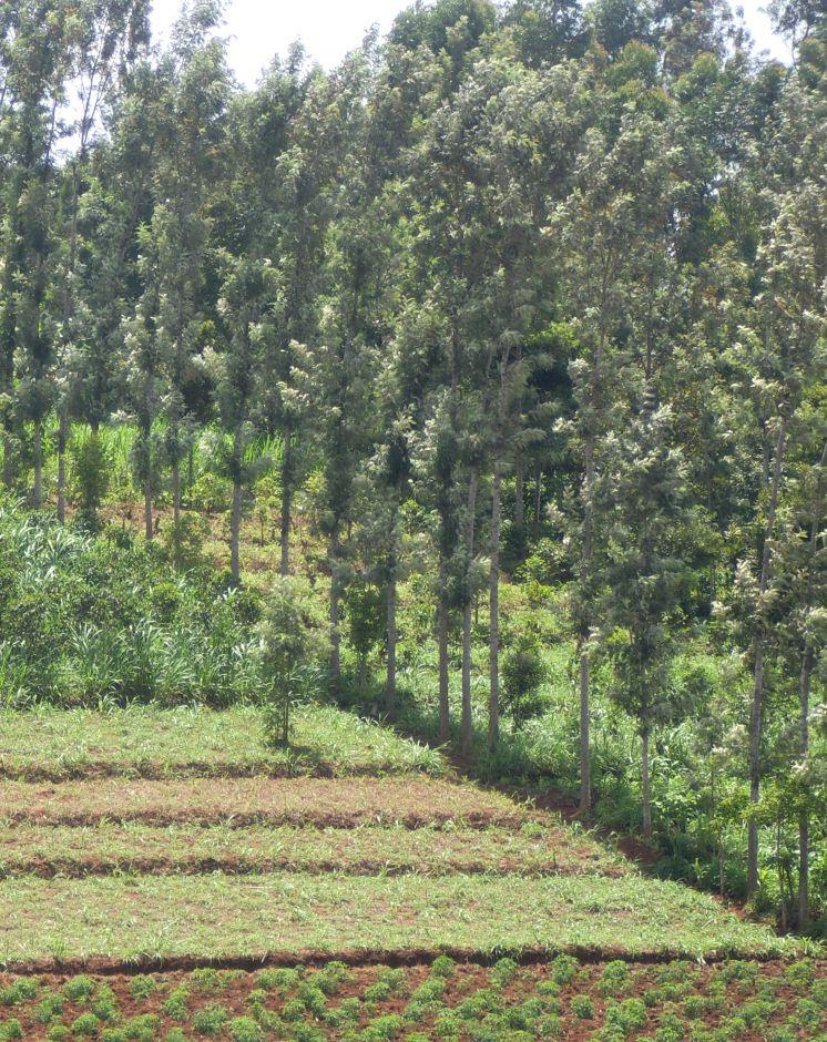
Windbreaks are narrow strips of trees, shrubs and/or grasses planted to protect fields, homes, canals, and other areas from the wind and blowing sand.
2.2 Detailed description of the Technology
Description:
Where wind is a major cause of soil erosion and moisture loss, windbreaks can make a significant contribution to sustainable production. They also be used to act as shelter-belts, a type of windbreak, are long, multiple rows of trees and shrubs, usually along sea coasts, to protect agricultural fields from inundation by tidal waves.
Purpose of the Technology: Windbreaks can make a significant contribution to sustainable production
Where wind is a major cause of soil erosion and moisture loss
It improves the microclimate in a given protected area by decreasing water evaporation from the soil and plants
Establishment / maintenance activities and inputs: Trees ( mainly Grivelia robusta) are planted in rows. They are maintained by regular pruning from the tender age to old age. Also, regular replacement of old trees. The trees are closely planted, about 1m apart and a maximum height of about 10m. The trees are always planted along the edges of the fields to protect the effects of mainly wind and the tidal waves. Surveying of the planting lines should be done to ensure they are linear
Natural / human environment: The trees are used as boundaries, firewood, timber and fence posts, they should be environmental friendly.
2.3 Photos of the Technology
Media Gallery
2.5 Country/ region/ locations where the Technology has been applied and which are covered by this assessment
Country:
Kenya
Region/ State/ Province:
Eastern Province
Further specification of location:
Mbeere South District
Specify the spread of the Technology:
- evenly spread over an area
If precise area is not known, indicate approximate area covered:
- 0.1-1 km2
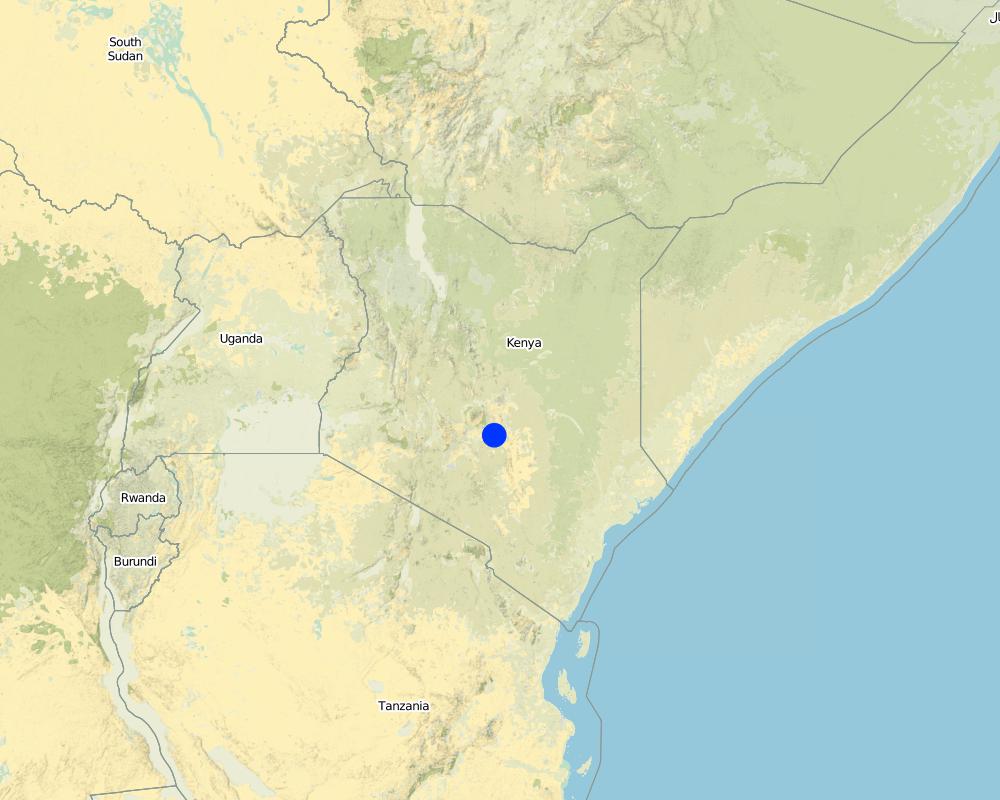
Map
×2.6 Date of implementation
If precise year is not known, indicate approximate date:
- 10-50 years ago
2.7 Introduction of the Technology
Specify how the Technology was introduced:
- through land users' innovation
3. Classification of the SLM Technology
3.1 Main purpose(s) of the Technology
- improve production
- reduce, prevent, restore land degradation
- adapt to climate change/ extremes and its impacts
- create beneficial economic impact
3.2 Current land use type(s) where the Technology is applied

Cropland
- Annual cropping
Number of growing seasons per year:
- 2

Forest/ woodlands
- Tree plantation, afforestation
Type of tree:
- Grevillea robusta
Products and services:
- Nature conservation/ protection
- Protection against natural hazards
Comments:
Major land use problems (compiler’s opinion): There is a lot of wind erosion that leads to low land productivity.
Major land use problems (land users’ perception): Soil erosion of the top soil.
Future (final) land use (after implementation of SLM Technology): Cropland: Ca: Annual cropping
3.3 Has land use changed due to the implementation of the Technology?
Cropland
- Annual cropping
3.4 Water supply
Water supply for the land on which the Technology is applied:
- mixed rainfed-irrigated
3.5 SLM group to which the Technology belongs
- windbreak/ shelterbelt
3.6 SLM measures comprising the Technology

vegetative measures
- V1: Tree and shrub cover
Comments:
Type of vegetative measures: aligned: -along boundary
3.7 Main types of land degradation addressed by the Technology

soil erosion by wind
- Et: loss of topsoil
Comments:
Main causes of degradation: wind storms / dust storms
Secondary causes of degradation: soil management, crop management (annual, perennial, tree/shrub), droughts, land tenure
3.8 Prevention, reduction, or restoration of land degradation
Specify the goal of the Technology with regard to land degradation:
- prevent land degradation
- restore/ rehabilitate severely degraded land
4. Technical specifications, implementation activities, inputs, and costs
4.1 Technical drawing of the Technology
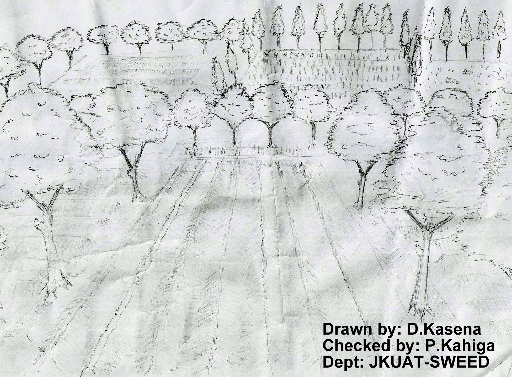
Technical specifications (related to technical drawing):
The technical drawing on the left hand shows boundary trees planted either along boundaries between farmers or between different portions of two crop stands. The spacing between the crops depend on the type of particular tree. The most common boundary trees used in Embu County is gravellia trees that have multiple uses (firewood, timber, animal feeds - leaves during the dry spells and mulch to some extent)
Location: Embu. Central Province
Date: 13.02.2013
Technical knowledge required for field staff / advisors: moderate (The technology does not require a lot of skills to demonstrate to the farmers. Just basic skills on spacing and vertical interval)
Technical knowledge required for land users: low (The basic skills of the farmer required to effect the technology)
Main technical functions: stabilisation of soil (eg by tree roots against land slides), reduction in wind speed
Aligned: -contour
Vegetative material: T : trees / shrubs
Aligned: -along boundary
Vegetative material: T : trees / shrubs
Number of plants per (ha): 400
Vertical interval between rows / strips / blocks (m): 20
Spacing between rows / strips / blocks (m): 5
Vertical interval within rows / strips / blocks (m): 0.3
Width within rows / strips / blocks (m): 0.5
Trees/ shrubs species: Grivelia robusta
Grass species: Napier grass
Slope (which determines the spacing indicated above): 5%%
If the original slope has changed as a result of the Technology, the slope today is (see figure below): 5%%
Author:
Paul Kahiga, 8444-00300, Nairobi-Kenya
4.2 General information regarding the calculation of inputs and costs
other/ national currency (specify):
KSh
If relevant, indicate exchange rate from USD to local currency (e.g. 1 USD = 79.9 Brazilian Real): 1 USD =:
85.0
Indicate average wage cost of hired labour per day:
4.70
4.3 Establishment activities
| Activity | Timing (season) | |
|---|---|---|
| 1. | Establishing contours | Each cropping season |
| 2. | Digging of holes | Before the cropping season |
| 3. | Planting of trees | After the digging of holes |
4.4 Costs and inputs needed for establishment
| Specify input | Unit | Quantity | Costs per Unit | Total costs per input | % of costs borne by land users | |
|---|---|---|---|---|---|---|
| Labour | Labour | ha | 1.0 | 470.0 | 470.0 | 100.0 |
| Equipment | Tools | ha | 1.0 | 5.3 | 5.3 | 100.0 |
| Plant material | Seedlings | ha | 1.0 | 480.0 | 480.0 | 100.0 |
| Fertilizers and biocides | Compost/manure | ha | 1.0 | 3.5 | 3.5 | 100.0 |
| Total costs for establishment of the Technology | 958.8 | |||||
| Total costs for establishment of the Technology in USD | 11.28 | |||||
Comments:
Duration of establishment phase: 24 month(s)
4.5 Maintenance/ recurrent activities
| Activity | Timing/ frequency | |
|---|---|---|
| 1. | Prunning | Each cropping season |
| 2. | Pruning | Onset of planting season |
4.6 Costs and inputs needed for maintenance/ recurrent activities (per year)
| Specify input | Unit | Quantity | Costs per Unit | Total costs per input | % of costs borne by land users | |
|---|---|---|---|---|---|---|
| Labour | Labour | ha | 1.0 | 470.0 | 470.0 | 100.0 |
| Total costs for maintenance of the Technology | 470.0 | |||||
| Total costs for maintenance of the Technology in USD | 5.53 | |||||
4.7 Most important factors affecting the costs
Describe the most determinate factors affecting the costs:
If the land has a gentle sloping gradient, the trees need to be closely planted o reduce the effects of the winds and storms to the crops.
5. Natural and human environment
5.1 Climate
Annual rainfall
- < 250 mm
- 251-500 mm
- 501-750 mm
- 751-1,000 mm
- 1,001-1,500 mm
- 1,501-2,000 mm
- 2,001-3,000 mm
- 3,001-4,000 mm
- > 4,000 mm
Specifications/ comments on rainfall:
The area receives relatively good amount of rainfall
Agro-climatic zone
- sub-humid
- semi-arid
5.2 Topography
Slopes on average:
- flat (0-2%)
- gentle (3-5%)
- moderate (6-10%)
- rolling (11-15%)
- hilly (16-30%)
- steep (31-60%)
- very steep (>60%)
Landforms:
- plateau/plains
- ridges
- mountain slopes
- hill slopes
- footslopes
- valley floors
Altitudinal zone:
- 0-100 m a.s.l.
- 101-500 m a.s.l.
- 501-1,000 m a.s.l.
- 1,001-1,500 m a.s.l.
- 1,501-2,000 m a.s.l.
- 2,001-2,500 m a.s.l.
- 2,501-3,000 m a.s.l.
- 3,001-4,000 m a.s.l.
- > 4,000 m a.s.l.
5.3 Soils
Soil depth on average:
- very shallow (0-20 cm)
- shallow (21-50 cm)
- moderately deep (51-80 cm)
- deep (81-120 cm)
- very deep (> 120 cm)
Soil texture (topsoil):
- medium (loamy, silty)
Topsoil organic matter:
- medium (1-3%)
If available, attach full soil description or specify the available information, e.g. soil type, soil PH/ acidity, Cation Exchange Capacity, nitrogen, salinity etc.
Soil texture: Medium (the soils are relatively friable)
Soil fertility: Medium (limited crops for productivity)
Topsoil organic matter: Medium (gently sloping lands)
Soil drainage/infiltration: Medium (the soils are relatively good drained)
Soil water storage capacity: Medium (soils have medium water holding capacity due to high intensities of sun rays)
5.4 Water availability and quality
Ground water table:
> 50 m
Availability of surface water:
medium
Water quality (untreated):
poor drinking water (treatment required)
5.5 Biodiversity
Species diversity:
- low
5.6 Characteristics of land users applying the Technology
Market orientation of production system:
- mixed (subsistence/ commercial)
Off-farm income:
- 10-50% of all income
Relative level of wealth:
- average
Individuals or groups:
- individual/ household
Level of mechanization:
- manual work
Gender:
- women
- men
Indicate other relevant characteristics of the land users:
Land users applying the Technology are mainly common / average land users
Difference in the involvement of women and men: Men ensure establishment and women ensure good maintenance of the technology
Population density: > 500 persons/km2
Annual population growth: 1% - 2%
(Most people have avaragely living standards).
Off-farm income specification: There is increased production since the trees once grown big can be cut and provide timber
5.7 Average area of land used by land users applying the Technology
- < 0.5 ha
- 0.5-1 ha
- 1-2 ha
- 2-5 ha
- 5-15 ha
- 15-50 ha
- 50-100 ha
- 100-500 ha
- 500-1,000 ha
- 1,000-10,000 ha
- > 10,000 ha
Is this considered small-, medium- or large-scale (referring to local context)?
- small-scale
5.8 Land ownership, land use rights, and water use rights
Land ownership:
- individual, not titled
Land use rights:
- individual
5.9 Access to services and infrastructure
health:
- poor
- moderate
- good
education:
- poor
- moderate
- good
6. Impacts and concluding statements
6.1 On-site impacts the Technology has shown
Socio-economic impacts
Production
wood production
product diversity
land management
Income and costs
farm income
Socio-cultural impacts
SLM/ land degradation knowledge
conflict mitigation
Improved livelihoods and human well-being
Ecological impacts
Biodiversity: vegetation, animals
habitat diversity
Climate and disaster risk reduction
wind velocity
6.2 Off-site impacts the Technology has shown
wind transported sediments
6.3 Exposure and sensitivity of the Technology to gradual climate change and climate-related extremes/ disasters (as perceived by land users)
Climate-related extremes (disasters)
Meteorological disasters
| How does the Technology cope with it? | |
|---|---|
| local windstorm | well |
6.4 Cost-benefit analysis
How do the benefits compare with the establishment costs (from land users’ perspective)?
Short-term returns:
positive
Long-term returns:
positive
How do the benefits compare with the maintenance/ recurrent costs (from land users' perspective)?
Short-term returns:
positive
Long-term returns:
positive
6.5 Adoption of the Technology
Comments:
There is a strong trend towards spontaneous adoption of the Technology
6.7 Strengths/ advantages/ opportunities of the Technology
| Strengths/ advantages/ opportunities in the compiler’s or other key resource person’s view |
|---|
| Reduce wind speed |
| They produce fruit, nuts, maple syrup, firewood, posts, poles and veneer |
| They provide nectar and pollen for bees |
| Wind breaks protect a variety of wind-sensitive crops |
| Acts as sound barriers and mitigate odors from neighboring properties |
6.8 Weaknesses/ disadvantages/ risks of the Technology and ways of overcoming them
| Weaknesses/ disadvantages/ risks in the land user’s view | How can they be overcome? |
|---|---|
| complicates equipment movement | Proper spacing to allow movement of equipment |
| Establishment and maintenance costs | The establishment and maintenance cost cant be equaled with the overall benefits |
| Weaknesses/ disadvantages/ risks in the compiler’s or other key resource person’s view | How can they be overcome? |
|---|---|
| Loss of space that could otherwise be utilized by food crops | Appropriate spacing even though the effect has less magnitude because it is established along the boundaries |
| Shading effects, effects on micro-climate and harbors pests. | Avoid very tall windbreaks which shades excessively and are susceptible to breakages. Use of appropriate chemicals for spraying the pests. |
| Competition for water and nutrients | Supplemental irrigation in times of droughts |
7. References and links
7.1 Methods/ sources of information
- field visits, field surveys
- interviews with land users
When were the data compiled (in the field)?
18/09/2012
Links and modules
Expand all Collapse allLinks
No links
Modules
No modules