Callejones de piñón con forrajes intercalados [Mexico]
- Creation:
- Update:
- Compiler: BENJAMIN SANCHEZ BERNAL
- Editors: Francisco Becerra-Luna, FELIPE HEREDIA, Adriana Gonzalez
- Reviewers: Johanna Jacobi, Joana Eichenberger
No tiene nombre
technologies_3728 - Mexico
View sections
Expand all Collapse all1. General information
1.2 Contact details of resource persons and institutions involved in the assessment and documentation of the Technology
Key resource person(s)
land user:
Mexico
Name of project which facilitated the documentation/ evaluation of the Technology (if relevant)
FAOMEX-Protierras ( FAO México - GEF)1.3 Conditions regarding the use of data documented through WOCAT
The compiler and key resource person(s) accept the conditions regarding the use of data documented through WOCAT:
Ja
1.4 Declaration on sustainability of the described Technology
Is the Technology described here problematic with regard to land degradation, so that it cannot be declared a sustainable land management technology?
Nee
1.5 Reference to Questionnaire(s) on SLM Approaches (documented using WOCAT)
Participatory catchment rehabilitation (Participación comunitaria para la rehabilitación … [Peru]
Promoting the rehabilitation of ancient terrace systems based on a systematic watershed management approach.
- Compiler: Philippe Zahner
Dissemination of soil conservation technologies in dryland areas [Chile]
Dissemination of no tillage with subsoiling in the Municipality of Yumbel
- Compiler: Carlos Ovalle
Farmer Field Schools [Kenya]
A Farmer Field School (FFS) is a community-based practically-oriented field study programme.
- Compiler: Philippe Zahner
2. Description of the SLM Technology
2.1 Short description of the Technology
Definition of the Technology:
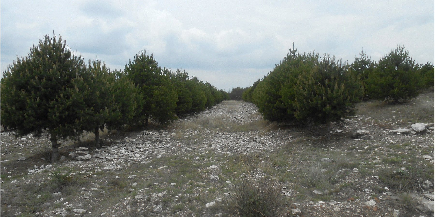
La tecnología consiste en un sistema agrosilvopastoril con árboles de Pinus cembroides (pino piñonero) alineados een bordos ─en un terreno con suelos calizos previamente subsoleado─ conformando melgas (callejones) para con cultivos anuales para grano y forraje, con pastoreo libre eventual por períodos muy breves.
2.2 Detailed description of the Technology
Description:
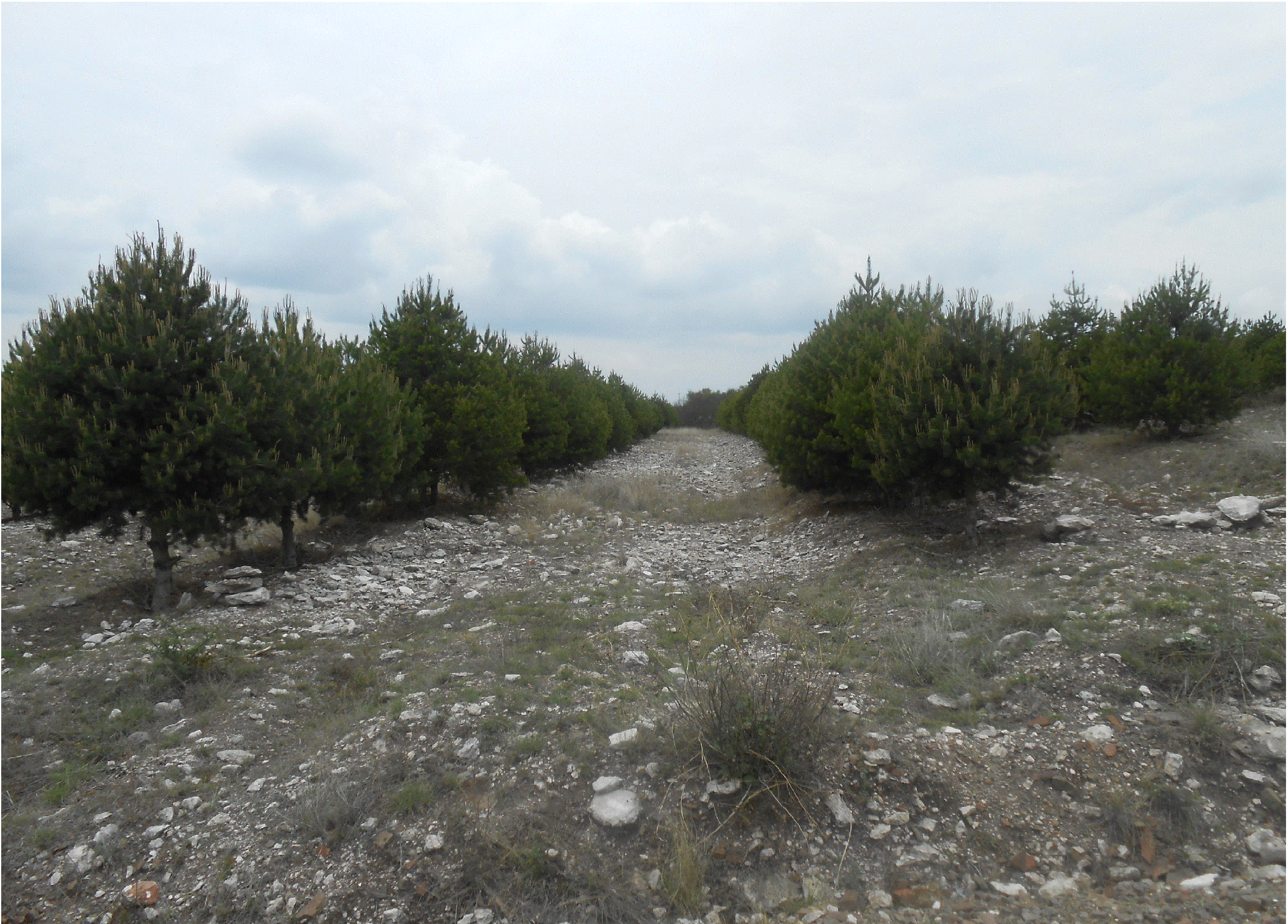
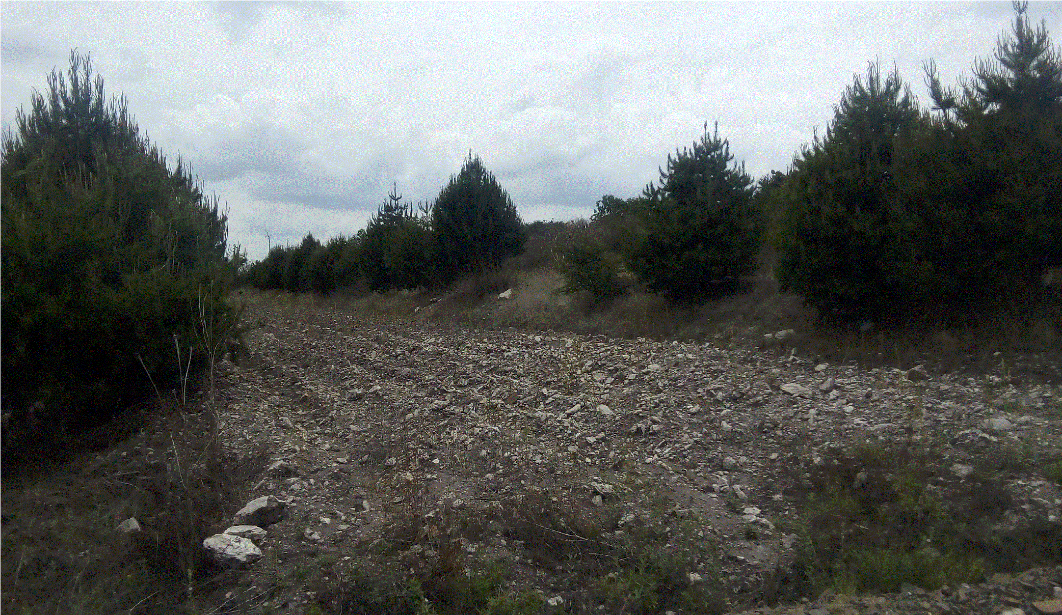
La tecnología se desarrolla en un sitio denominado “La Joya” en el ejido Hermosillo por un productor que implementó el sistema agrosilvopastoril cuyo terreno no tenia aptitud agrícola por ser un suelo poco profundo, con presencia de calizas y una pendiente de 15%, La tecnología consiste en realizar paso de subsoleo para romper capas denominadas tepetates localmente (duripanes), Posteriormente se realizó cepas de 0.50 m de ancho x 0.50 m de largo y 0.40m de profundidad en forma manual. Se manejan dos diseños de plantación, siendo el primero de 8 m de ancho entre hileras y 2.00 m de distancia entre árboles; y, el segundo de 4.00m x 2.00 m respectivamente. En ambos diseños se plantaron árboles de Pinus cembroides (Pino piñonero), cuya especie es nativa de la micro región (MR). Respecto al diseño cuyas melgas son mas anchas, se siembra frijol para autoconsumo y maíz para forraje. En tanto en el diseño de melgas mas angostas se siembra cereales pequeños para forraje (cebada y avena) sin control químico. El sistema se cierra con el pastoreo libre en periodos cortos (de noviembre a diciembre) lo cual ayuda a tener un control de malezas. El objetivo principal del sistema es obtener ingresos de la producción del piñón como una meta a mediano y largo plazo. También como objetivos específicos; el productor señala beneficios ambientales tales como aire puro, humedad relativa, mejor calidad de suelo para producir y retorno de fauna.
El sistema demanda más mano de obra en épocas específicas en comparación a los sistemas tradicionales de producción agrícolas locales. Asimismo, el costo de la inversión inicial es alto; no obstante que disminuyen los gastos recurrentes en los años subsecuentes, debido a la preparación del suelo y establecimiento de la plantación. Los beneficios observados son el incremento y diversificación de la producción, concentración de actividades productivas en superficies reducidas, percepción de mejoras en los bienes y servicios ambientales (control de la erosión, humedad suelo, recreativos, etc.). Además el usuario tiene intenciones de incorporar a su sistema la sustitución de cultivos anuales por maguey pulquero (Agave salmiana). Se considera que esta tecnología es una innovación con apoyo familiar, sin haber recibido ningún subsidio gubernamental o privado, cuya asistencia técnica es proporcionada por los hijos. Es importante subrayar que los beneficios y costos señalados en esta sistematización son en 8 años desde la plantación, pudiendo tener una producción estable a partir de los 10 años, con eventuales oscilaciones en la producción conocidas como año semillero.
2.3 Photos of the Technology
Media Gallery
2.5 Country/ region/ locations where the Technology has been applied and which are covered by this assessment
Country:
Mexico
Region/ State/ Province:
Microregión Valle del Mezquital/Hidalgo/Centro de México
Further specification of location:
Santiago de Anaya, Hidalgo.
Specify the spread of the Technology:
- applied at specific points/ concentrated on a small area
Map
×2.6 Date of implementation
Indicate year of implementation:
2010
If precise year is not known, indicate approximate date:
- less than 10 years ago (recently)
2.7 Introduction of the Technology
Specify how the Technology was introduced:
- through land users' innovation
3. Classification of the SLM Technology
3.1 Main purpose(s) of the Technology
- conserve ecosystem
- preserve/ improve biodiversity
- create beneficial social impact
3.4 Water supply
Water supply for the land on which the Technology is applied:
- rainfed
3.5 SLM group to which the Technology belongs
- forest plantation management
- integrated crop-livestock management
3.6 SLM measures comprising the Technology

agronomic measures
- A1: Vegetation/ soil cover
- A4: Subsurface treatment

vegetative measures
- V1: Tree and shrub cover

management measures
- M6: Waste management (recycling, re-use or reduce)
3.7 Main types of land degradation addressed by the Technology

soil erosion by water
- Wt: loss of topsoil/ surface erosion

physical soil deterioration
- Pk: slaking and crusting
3.8 Prevention, reduction, or restoration of land degradation
Specify the goal of the Technology with regard to land degradation:
- reduce land degradation
- restore/ rehabilitate severely degraded land
4. Technical specifications, implementation activities, inputs, and costs
4.1 Technical drawing of the Technology
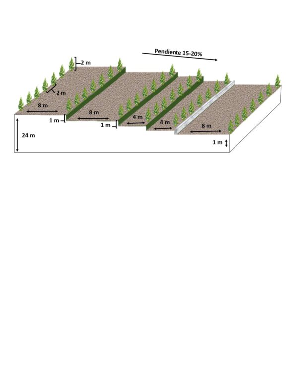
Author:
Julio Cesar Rangel
Date:
09/05/2018
Author:
Julio Cesar Rangel
Date:
09/05/2018
4.2 General information regarding the calculation of inputs and costs
Specify how costs and inputs were calculated:
- per Technology area
Indicate size and area unit:
1.179 ha
other/ national currency (specify):
Pesos mexicanos
If relevant, indicate exchange rate from USD to local currency (e.g. 1 USD = 79.9 Brazilian Real): 1 USD =:
19.36
Indicate average wage cost of hired labour per day:
$150.00 por jornal o día
4.4 Costs and inputs needed for establishment
| Specify input | Unit | Quantity | Costs per Unit | Total costs per input | % of costs borne by land users | |
|---|---|---|---|---|---|---|
| Labour | None | None | 26.0 | 150.0 | 3900.0 | 100.0 |
| Equipment | None | None | 4.0 | 1500.0 | 6000.0 | 50.0 |
| Equipment | None | None | 4.0 | 600.0 | 2400.0 | 100.0 |
| Fertilizers and biocides | None | None | 525.0 | 2.5 | 1312.5 | 100.0 |
| Total costs for establishment of the Technology | 13612.5 | |||||
| Total costs for establishment of the Technology in USD | 703.13 | |||||
4.6 Costs and inputs needed for maintenance/ recurrent activities (per year)
| Specify input | Unit | Quantity | Costs per Unit | Total costs per input | % of costs borne by land users | |
|---|---|---|---|---|---|---|
| Labour | None | None | 15.0 | 150.0 | 2250.0 | 100.0 |
| Labour | None | None | 14.0 | 150.0 | 2100.0 | 100.0 |
| Labour | None | None | 30.0 | 50.0 | 1500.0 | 100.0 |
| Equipment | None | None | 1.0 | 700.0 | 700.0 | 100.0 |
| Equipment | None | None | 3.0 | 260.0 | 780.0 | 100.0 |
| Equipment | None | None | 2.0 | 260.0 | 520.0 | 100.0 |
| Equipment | None | None | 2.0 | 600.0 | 1200.0 | 100.0 |
| Plant material | None | None | 130.0 | 6.0 | 780.0 | 100.0 |
| Plant material | None | None | 2.5 | 15.0 | 37.5 | 100.0 |
| Plant material | None | None | 4.5 | 25.0 | 112.5 | 100.0 |
| Fertilizers and biocides | None | None | 1.0 | 150.0 | 150.0 | 100.0 |
| Total costs for maintenance of the Technology | 10130.0 | |||||
| Total costs for maintenance of the Technology in USD | 523.24 | |||||
5. Natural and human environment
5.1 Climate
Annual rainfall
- < 250 mm
- 251-500 mm
- 501-750 mm
- 751-1,000 mm
- 1,001-1,500 mm
- 1,501-2,000 mm
- 2,001-3,000 mm
- 3,001-4,000 mm
- > 4,000 mm
Specify average annual rainfall (if known), in mm:
487.00
Agro-climatic zone
- arid
5.2 Topography
Slopes on average:
- flat (0-2%)
- gentle (3-5%)
- moderate (6-10%)
- rolling (11-15%)
- hilly (16-30%)
- steep (31-60%)
- very steep (>60%)
Landforms:
- plateau/plains
- ridges
- mountain slopes
- hill slopes
- footslopes
- valley floors
Altitudinal zone:
- 0-100 m a.s.l.
- 101-500 m a.s.l.
- 501-1,000 m a.s.l.
- 1,001-1,500 m a.s.l.
- 1,501-2,000 m a.s.l.
- 2,001-2,500 m a.s.l.
- 2,501-3,000 m a.s.l.
- 3,001-4,000 m a.s.l.
- > 4,000 m a.s.l.
Indicate if the Technology is specifically applied in:
- not relevant
5.3 Soils
Soil depth on average:
- very shallow (0-20 cm)
- shallow (21-50 cm)
- moderately deep (51-80 cm)
- deep (81-120 cm)
- very deep (> 120 cm)
Soil texture (topsoil):
- coarse/ light (sandy)
Soil texture (> 20 cm below surface):
- coarse/ light (sandy)
Topsoil organic matter:
- low (<1%)
5.4 Water availability and quality
Ground water table:
> 50 m
Availability of surface water:
poor/ none
Water quality (untreated):
unusable
Is flooding of the area occurring?
Nee
5.5 Biodiversity
Species diversity:
- medium
Habitat diversity:
- medium
5.6 Characteristics of land users applying the Technology
Sedentary or nomadic:
- Sedentary
Market orientation of production system:
- subsistence (self-supply)
- mixed (subsistence/ commercial)
Off-farm income:
- 10-50% of all income
Relative level of wealth:
- average
Individuals or groups:
- individual/ household
Level of mechanization:
- animal traction
Gender:
- men
Age of land users:
- middle-aged
- elderly
5.7 Average area of land used by land users applying the Technology
- < 0.5 ha
- 0.5-1 ha
- 1-2 ha
- 2-5 ha
- 5-15 ha
- 15-50 ha
- 50-100 ha
- 100-500 ha
- 500-1,000 ha
- 1,000-10,000 ha
- > 10,000 ha
Is this considered small-, medium- or large-scale (referring to local context)?
- small-scale
5.8 Land ownership, land use rights, and water use rights
Land ownership:
- individual, not titled
Land use rights:
- individual
5.9 Access to services and infrastructure
health:
- poor
- moderate
- good
education:
- poor
- moderate
- good
technical assistance:
- poor
- moderate
- good
employment (e.g. off-farm):
- poor
- moderate
- good
markets:
- poor
- moderate
- good
energy:
- poor
- moderate
- good
roads and transport:
- poor
- moderate
- good
drinking water and sanitation:
- poor
- moderate
- good
financial services:
- poor
- moderate
- good
6. Impacts and concluding statements
6.1 On-site impacts the Technology has shown
Socio-economic impacts
Production
crop production
crop quality
fodder production
fodder quality
animal production
wood production
forest/ woodland quality
non-wood forest production
risk of production failure
product diversity
production area
land management
Income and costs
expenses on agricultural inputs
farm income
diversity of income sources
workload
Socio-cultural impacts
food security/ self-sufficiency
health situation
recreational opportunities
SLM/ land degradation knowledge
Ecological impacts
Water cycle/ runoff
surface runoff
excess water drainage
evaporation
Soil
soil moisture
soil cover
soil loss
soil crusting/ sealing
soil compaction
nutrient cycling/ recharge
salinity
soil organic matter/ below ground C
acidity
Biodiversity: vegetation, animals
Vegetation cover
biomass/ above ground C
plant diversity
invasive alien species
animal diversity
beneficial species
habitat diversity
pest/ disease control
Climate and disaster risk reduction
drought impacts
impacts of cyclones, rain storms
emission of carbon and greenhouse gases
fire risk
wind velocity
micro-climate
6.3 Exposure and sensitivity of the Technology to gradual climate change and climate-related extremes/ disasters (as perceived by land users)
Gradual climate change
Gradual climate change
| Season | increase or decrease | How does the Technology cope with it? | |
|---|---|---|---|
| annual temperature | increase | not known | |
| seasonal temperature | summer | increase | not known |
| annual rainfall | decrease | not known | |
| seasonal rainfall | summer | decrease | not known |
Climate-related extremes (disasters)
Meteorological disasters
| How does the Technology cope with it? | |
|---|---|
| tropical storm | well |
| extra-tropical cyclone | not known |
| local rainstorm | not known |
| local thunderstorm | well |
| local hailstorm | well |
| local snowstorm | not known |
Climatological disasters
| How does the Technology cope with it? | |
|---|---|
| heatwave | well |
6.4 Cost-benefit analysis
How do the benefits compare with the establishment costs (from land users’ perspective)?
Short-term returns:
positive
Long-term returns:
positive
How do the benefits compare with the maintenance/ recurrent costs (from land users' perspective)?
Short-term returns:
slightly negative
Long-term returns:
slightly positive
6.5 Adoption of the Technology
- single cases/ experimental
Of all those who have adopted the Technology, how many did so spontaneously, i.e. without receiving any material incentives/ payments?
- 91-100%
6.6 Adaptation
Has the Technology been modified recently to adapt to changing conditions?
Nee
7. References and links
7.1 Methods/ sources of information
- field visits, field surveys
- interviews with land users
- interviews with SLM specialists/ experts
When were the data compiled (in the field)?
09/05/2018
Links and modules
Expand all Collapse allLinks
Participatory catchment rehabilitation (Participación comunitaria para la rehabilitación … [Peru]
Promoting the rehabilitation of ancient terrace systems based on a systematic watershed management approach.
- Compiler: Philippe Zahner
Dissemination of soil conservation technologies in dryland areas [Chile]
Dissemination of no tillage with subsoiling in the Municipality of Yumbel
- Compiler: Carlos Ovalle
Farmer Field Schools [Kenya]
A Farmer Field School (FFS) is a community-based practically-oriented field study programme.
- Compiler: Philippe Zahner
Modules
No modules