Permeable rock dikes [بوركينا فاسو]
- تاريخ الإنشاء:
- تحديث:
- جامع المعلومات: Dieter Nill
- المحرر: –
- المُراجع: Deborah Niggli
Diguettes filtrantes (French)
technologies_1619 - بوركينا فاسو
عرض الأقسام
توسيع الكل طي الكل1. معلومات عامة
1.2 تفاصيل الاتصال بالأشخاص الرئيسيين لمصدر المعلومات والمؤسسات المشاركة في تقييم وتوثيق التقنية
متخصص في الإدارة المستدامة للأراضي:
Sani Mamadou Abdou
mamadou.sani@giz.de
Programme d’Appui à l’agriculture Productive (PROMAP), Niamey, Niger
النيجر
اسم المشروع الذي سهّل توثيق/تقييم التقنية (إذا كان ذلك على صلة)
Good Practices in Soil and Water Conservation - A contribution to adaptation and farmers ́ resilience towards climate change in the Sahel (GIZ)اسم المؤسسة (المؤسسات) التي سهلت توثيق/تقييم التقنية (إذا كان ذلك على صلة)
Deutsche Gesellschaft für Internationale Zusammenarbeit (GIZ) GmbH (GIZ) - ألمانيا1.3 الشروط المتعلقة باستخدام البيانات الموثقة من خلال WOCAT
متى تم تجميع البيانات (ميدانيا)؟:
01/07/2012
يوافق جامع المعلومات والشخص (لاشخاص) الرئيسي لمصدر المعلومات على الشروط المتعلقة باستخدام البيانات الموثقة من خلال WOCAT:
نعم
1.4 إعلان بشأن استدامة التقنية الموصوفة
هل التقنية الموصوفة هنا تمثل مشكلة فيما يتعلق بتدهور الأراضي، بحيث لا يمكن إعلانها تقنية مستدامة لإدارة الأراضي؟:
كلا
2. وصف تقنيةالإدارة المستدامي للأراضي
2.1 وصف مختصر للتقنية
تعريف التقنية:
Permeable rock dikes are erosion control structures to slow down runoff
2.2 وصف تفصيلي للتقنية
الوصف:
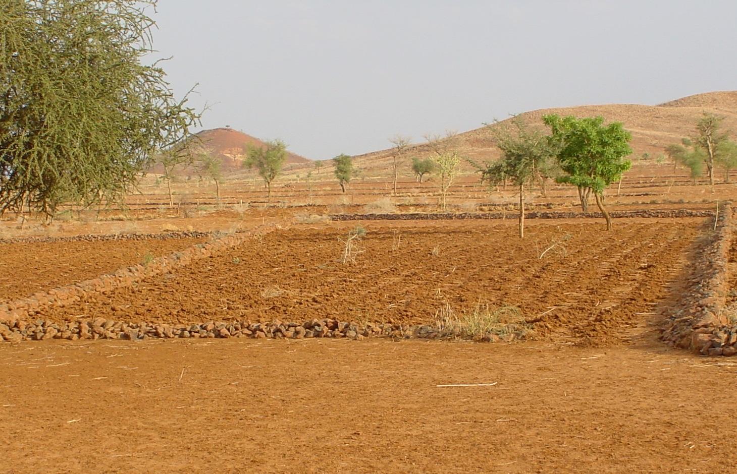
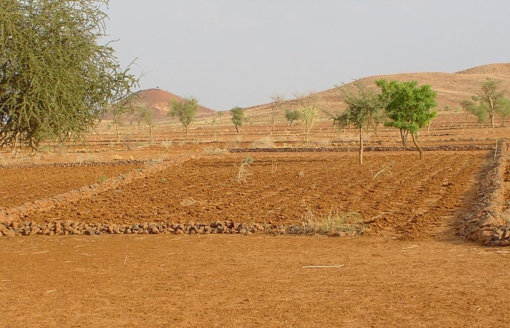
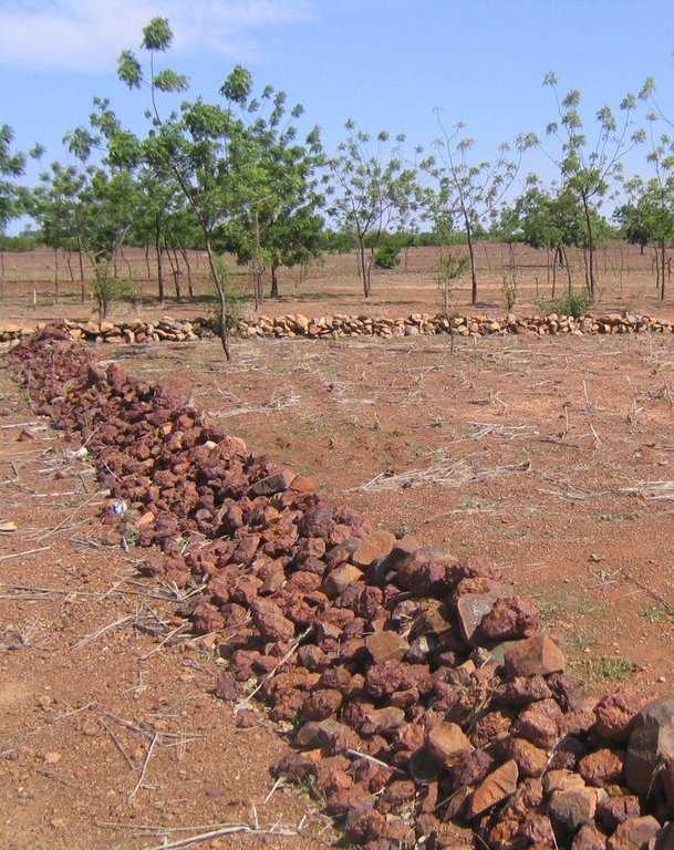
Permeable rock dikes are erosion control structures built along the natural contour of the land and designed to slow down runoff. They are built between 30 and 50 cm high and twice or three times as wide as they are high. They are made with different-sized stones and rocks, and the crest of the dike is horizontal. There are two main types of permeable rock dike: those without a filter layer, which are suitable for flat land with no gully erosion and those with a filter layer suited to land with heavy runoff.
Because of the way it is constructed, it dissipates the erosive force of the water. Sediment builds up behind it, resulting in the formation of terraces. It also increases the infiltration of surface water into the soil. The retention of water and fertile sediment by the dikes facilitates the development of natural vegetation along the structure. Grass and bush seeds are trapped by the dikes, favouring the spontaneous growth of natural vegetation, which contributes to restoring biodiversity and provides a habitat for wildlife. Good tree and grass cover developed along the dikes contributes to lowering soil temperature and reducing wind erosion along the entire length of the structure.
The reduction in runoff downstream of the dikes contributes to reducing alluvial deposits in the valleys further downstream. Watershed development with permeable rock dikes reduces siltation and gully erosion.
Permeable rock dikes are designed for use on cropland, but can also be used on forest/rangeland. They are recommended for ecological units with gravely and sandy-clayey soils and pediments. They can also be used to fill in small rills.
Studies conducted in the PATECORE area show that plots with permeable rock dikes averaged sorghum yields of 795 kg compared with 576 kg on control plots, which means that yields were 38% higher on improved plots. The production of straw for livestock increases in the same proportion as grain output.
With some upkeep, permeable rock dikes last at least 20 years. Before the rainy season starts, any stones dislodged by animals must be replaced. During the rainy season, the water can wear gaps in the dikes, which must be repaired immediately. The stability of the dikes can be reinforced by active revegetation (by sowing grass or planting trees). Without direct sowing, natural vegetation develops along the dikes after several years.
From the point of view of climate change adaptation, permeable rock dikes mitigate the effects of variations in rainfall. They are appropriate in wet period with heavy rain and violent downpours: permeable rock dikes constructed on the upper edge of the plot as a protective measure and a means of improving infiltration, protect land at risk from erosion. They are also appropriate during dry periods as they stop or slow down the flow of water. Permeable rock dikes improve infiltration and therefore increase and prolong the availability of water for crops. The permeable rock dike differs from the contour stone bund in that it is bigger in size, is constructed with various layers of stones and is designed to control stronger water flow. For this reason, such dikes are often constructed up-stream of stone bunds to dissipate the force of the water flowing from the plateaux and slopes.
2.3 صور التقنية
2.5 البلد/المنطقة/المواقع التي تم تنفيذ التقنية فيها والتي يغطيها هذا التقييم
البلد:
بوركينا فاسو
المنطقة/الولاية/المحافظة:
Burkina Faso, Chad
2.6 تاريخ التنفيذ
في حالة عدم معرفة السنة بالتحديد، يرجى الإشارة إلى التاريخ التقريبي:
- منذ 10-50 سنة
2.7 إدخال التقنية
حدد كيف تم إدخال التقنية:
- من خلال المشاريع/ التدخلات الخارجية
التعليقات (نوع المشروع، الخ):
developed, implemented and disseminated as part of projects and programmes undertaken from the 1980s onwards to combat desertification and improve natural resource management. Implemented by GIZ (German Federal Enterprise for International Cooperation), and PATECORE (project for land development and resource conservation in Plateau Central)
3. تصنيف تقنية الإدارة المستدامي للأراضي
3.1 الغرض الرئيسي ( الأغراض الرئيسية) للتقنية
- الحد من تدهور الأراضي ومنعه وعكسه
3.2 نوع (أنواع) استخدام الأراضي الحالية حيث يتم تطبيق التقنية

الأراضي الزراعية
- زراعة سنوية

أراضي الرعي
أراضي الرعي الواسع النطاق:
- رعي شبه مرتحل
التعليقات:
Major land use problems (compiler’s opinion): surface runoff, soil erosion by water and wind, fertility decline
Constraints of common grazing land
Constraints of forested government-owned land or commons
3.3 مزيد من المعلومات حول استخدام الأراضي
عدد مواسم الزراعة في السنة:
- 1
حدد:
Longest growing period in days: 120, Longest growing period from month to month: August to October
3.4 مجموعةالإدارة المستدامة للأراضي التي تنتمي إليها هذه التقنية
- التدابير المتقاطعة للمنحدرات
3.6 التدابير التقنية في مجال إلادارة المستدامة للأراضي

التدابير البنيوية
- الحواجز والضفاف
3.7 الأنواع الرئيسية من تدهور الأراضي التي تناولتها التقنية

تآكل التربة بالمياه
- الوزن(Wt): فقدان التربة السطحية/تآكل السطح
- (Wg):الانجراف الخلجاني/ الخلجان
- (Wo:) تأثيرات التدهور من مواقع أخرى

تآكل التربة الناتج عن الرياح
- (Et): فقدان التربة السطحية

التدهور الكيميائي للتربة
- (Cn): تراجع الخصوبة وانخفاض محتوى المادة العضوية (غير ناتج عن الانجراف)

التدهور البيولوجي
- (Bc): تناقص الغطاء النباتي

تدهور المياه
- (Ha): التجفيف
التعليقات:
Main causes of degradation: crop management (annual, perennial, tree/shrub) (Unadapted landuse methods, reduced or abandoned fallow periods), floods, droughts, population pressure (rapidly growing population increasing pressure on land), land tenure (insecure access to land)
3.8 منع أو حد أو عكس تدهور الأراضي
تحديد هدف التقنية فيما يتعلق بتدهور الأراضي:
- الحد من تدهور الأراضي
- اصلاح/إعادة تأهيل الأراضي المتدهورة بشدة
4. المواصفات الفنية، وأنشطة التنفيذ، والمدخلات، والتكاليف
4.1 الرسم الفني للتقنية
4.2 المواصفات الفنية/شروحات الرسم الفني
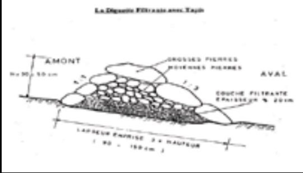
Permeable rock dikes are built between 30 and 50 cm high and twice or three times as wide as they are high. They are made with different-sized stones and rocks, and the crest of the dike is horizontal. There are two main types of permeable rock dike: those without a filter layer, which are suitable for flat land with no gully erosion and those with a filter layer suited to land with heavy runoff.
Technical knowledge required for field staff / advisors: moderate
Technical knowledge required for land users: low
Main technical functions: control of dispersed runoff: retain / trap, control of dispersed runoff: impede / retard, control of concentrated runoff: retain / trap, control of concentrated runoff: impede / retard, control of concentrated runoff: drain / divert, reduction of slope angle, improvement of ground cover, increase in nutrient availability (supply, recycling,…), increase of infiltration, increase / maintain water stored in soil, water harvesting / increase water supply, sediment retention / trapping, sediment harvesting
Secondary technical functions: stabilisation of soil (eg by tree roots against land slides), increase in organic matter, increase of groundwater level / recharge of groundwater, reduction in wind speed, promotion of vegetation species and varieties (quality, eg palatable fodder)
Bund/ bank: graded
Height of bunds/banks/others (m): 0.3-0.5
Width of bunds/banks/others (m): 1.5
4.4 أنشطة التأسيس
| النشاط | نوع التدبير | التوقيت | |
|---|---|---|---|
| 1. | levelling and marking out the contour line | بنيوية أو هيكلية | |
| 2. | collecting stones and loading them onto carts | بنيوية أو هيكلية | |
| 3. | transporting the stones by cart | بنيوية أو هيكلية | |
| 4. | building the dikes | بنيوية أو هيكلية | |
| 5. | applying manure | بنيوية أو هيكلية |
4.6 الصيانة/الأنشطة المتكررة
| النشاط | نوع التدبير | التوقيت/الوتيرة | |
|---|---|---|---|
| 1. | Before the rainy season starts, any stones dislodged by animals must be replaced. | بنيوية أو هيكلية | |
| 2. | During the rainy season, the water can wear gaps in the dikes, which must be repaired immediately. | بنيوية أو هيكلية |
4.7 التكاليف والمدخلات اللازمة للصيانة/للأنشطة المتكررة (سنويًا)
التعليقات:
Machinery/ tools: pickaxes, shovels, wheelbarrows, water-tube level, etc.
4.8 أهم العوامل المؤثرة على التكاليف
قدم وصفا لأهم العوامل التي تؤثر على التكاليف:
The exact cost of constructing permeable rock dikes per hectare depends on the distance of the site from the quarry, the inclination of the terrain, which determines the spacing between the dikes, and the actual amount of stones transported in each lorryload or cartload. Supply of quarry rock/stones: 48 m3 for 200 m of dike.
Labour: 60 man-days per ha
• levelling and marking out the contour line: 1 man-day
• collecting stones and loading them onto carts:
20 man-days
• transporting the stones by cart: 20 man-days
• building the dikes: 19 man-days
• applying manure.
Transportation by cart:
• 20 cartloads of stones
• 20 cartloads of manure (if used).
Transportation by lorry:
• 11 lorryloads (skip loader – 4.5 m3 per load).
Other costs:
• equipment (pickaxes, shovels, wheelbarrows, water-tube level, etc.).
5. البيئة الطبيعية والبشرية
5.1 المناخ
هطول الأمطار السنوي
- < 250 مم
- 251- 500 ملم
- 501 - 750ملم
- 1,000-751 ملم
- 1,500-1,100 ملم
- 2,000-1,500 ملم
- 3,000-2,001 ملم
- 4,000-3,100 ملم
- > 4000 ملم
المنطقة المناخية الزراعية
- شبه قاحلة
Thermal climate class: subtropics
5.2 طوبوغرافيا
متوسط الانحدارات:
- مسطح (0-2%)
- بسيط (3-5%)
- معتدل (6-10%)
- متدحرج (11-15%)
- تلال (16-30%)
- شديدة الانحدار(31-60%)
- فائقة الانحدار (>60%)
التضاريس:
- هضاب/سهول
- أثلام مرتفعة
- المنحدرات الجبلية
- منحدرات التلال
- منحدرات في السفوح
- قاع الوادي
المنطقة الارتفاعية:
- 100-0 متر فوق سطح البحر
- 500-101 متر فوق سطح البحر
- 1,000-501 متر فوق سطح البحر
- 1,500-1,001 متر فوق سطح البحر
- 2,000-1,501 متر فوق سطح البحر
- 2,500-2,100 متر فوق سطح البحر
- 3,000-2,501 متر فوق سطح البحر
- 4,000-3,001 متر فوق سطح البحر
- > 4000 متر فوق سطح البحر
5.3 التربة
متوسط عمق التربة:
- ضحل جدًا (0-20 سم)
- ضحلة (21-50 سم)
- متوسطة العمق (51-80 سم)
- عميقة (81-120 سم)
- عميقة جدًا (> 120 سم)
قوام التربة (التربة السطحية):
- متوسط ( طميي، سلتي)
- ناعم/ثقيل (طيني)
قوام التربة (> 20 سم تحت السطح):
- متوسط ( طميي، سلتي)
- ناعم/ثقيل (طيني)
5.4 توافر المياه ونوعيتها
منسوب المياه الجوفية:
50-5 م
توافر المياه السطحية:
متوسط
5.5 التنوع البيولوجي
تنوع الأنواع:
- منخفض
5.6 خصائص مستخدمي الأراضي الذين يطبقون التقنية
المستوى النسبي للثروة:
- ضعيف جدا
- ضعيف
الجنس:
- رجال
اذكر الخصائص الأخرى ذات الصلة لمستخدمي الأراضي:
Population density: 10-50 persons/km2
Annual population growth: 3% - 4% (mostly poor households below poverty line).
Off-farm income specification: men migrate temporarily or permanently to cities for off-farm income
5.7 متوسط مساحة الأرض المملوكة أو المستأجرة من قبل مستخدمي الأراضي الذين يطبقون التقنية
- < 0.5 هكتارا
- 0.5 - 1 هكتار
- 1 -2 هكتار
- 2 - 5 هكتار
- 5 - 15 هكتار
- 15 - 50 هكتار
- 50 - 100هكتار
- 500-100 هكتار
- 1,000-500 هكتار
- 10,000-1,000 هكتار
- > 10,000 هكتار
هل يعتبر هذا نطاقًا صغيرًا أو متوسطًا أو واسعا (في إشارة إلى السياق المحلي)؟:
- على نطاق صغير
5.8 ملكية الأراضي، وحقوق استخدام الأراضي، وحقوق استخدام المياه
ملكية الارض:
- دولة
حقوق استخدام الأراضي:
- مجتمعي (منظم)
حقوق استخدام المياه:
- مجتمعي (منظم)
التعليقات:
traditional land use rights on fields, communal land on pasture and forest land
5.9 الوصول إلى الخدمات والبنية التحتية
الصحة:
- ضعيف
- معتدل
- جيد
التعليم:
- ضعيف
- معتدل
- جيد
المساعدة التقنية:
- ضعيف
- معتدل
- جيد
العمل (على سبيل المثال خارج المزرعة):
- ضعيف
- معتدل
- جيد
الأسواق:
- ضعيف
- معتدل
- جيد
الطاقة:
- ضعيف
- معتدل
- جيد
الطرق والنقل:
- ضعيف
- معتدل
- جيد
مياه الشرب وخدمات الصرف الصحي:
- ضعيف
- معتدل
- جيد
الخدمات المالية:
- ضعيف
- معتدل
- جيد
6. الآثار والتصريحات الختامية
6.1 الآثار التي أظهرتها التقنية في الموقع
الآثار الاجتماعية والاقتصادية
الإنتاج
إنتاج المحاصيل
إنتاج الأعلاف
خطر فشل الإنتاج
الدخل والتكاليف
دخل المزرعة
الآثار الاجتماعية والثقافية
الأمن الغذائي / الاكتفاء الذاتي
التخفيف من حدة الصراع
contribution to human well-being
التعليقات/ حدد:
Studies conducted in the PATECORE area show that plots with permeable rock dikes averaged sorghum yields of 795 kg compared with 576 kg on control plots, which means that yields were 38% higher on improved plots. The production of straw for livestock increases in the same proportion as grain output.
الآثار الايكولوجية
دورة المياه / الجريان السطحي
حصاد / جمع المياه
الجريان السطحي
مستوى المياه الجوفية/ الطبقة المائية الجوفية
التربة
رطوبة التربة
غطاء التربة
فقدان التربة
دورة المغذيات/إعادة الشحن
التنوع البيولوجي: الغطاء النباتي، الحيوانات
التنوع النباتي
الحد من مخاطر المناخ والكوارث
سرعة الرياح
6.2 الآثار التي أظهرتها التقنية خارج الموقع
الفيضان في اتجاه مجرى النهر
تراكم الطمي باتجاه مصب النهر
الرواسب المنقولة بواسطة الرياح
الأضرار التي لحقت بحقول الجيران
6.3 تعرض التقنية وحساسيتها لتغير المناخ التدريجي والظواهر المتطرفة/الكوارث المرتبطة بالمناخ (كما يراها مستخدمو الأراضي)
تغير مناخ تدريجي
تغير مناخ تدريجي
| الموسم | نوع التغير المناخي/ المتطرف | كيف تتعامل التقنية مع ذلك؟ | |
|---|---|---|---|
| درجة الحرارة السنوية | زيادة | جيدا |
الظواهر المتطرفة / الكوارث المرتبطة بالمناخ
الكوارث الجوية
| كيف تتعامل التقنية مع ذلك؟ | |
|---|---|
| عاصفة ممطرة محلية | جيدا |
| عاصفة هوائية محلية | جيدا |
الكوارث المناخية
| كيف تتعامل التقنية مع ذلك؟ | |
|---|---|
| جفاف | جيدا |
الكوارث الهيدرولوجية
| كيف تتعامل التقنية مع ذلك؟ | |
|---|---|
| فيضان عام (نهر) | ليس جيدا |
العواقب الأخرى المتعلقة بالمناخ
العواقب الأخرى المتعلقة بالمناخ
| كيف تتعامل التقنية مع ذلك؟ | |
|---|---|
| انخفاض فترة النمو | جيدا |
6.4 تحليل التكلفة والعائد
كيف يمكن مقارنة العوائد نسبة لتكاليف الإنشاء (من وجهة نظر مستخدمي الأراضي)؟
عوائد قصيرة الأجل:
إيجابي
عوائد طويلة الأجل:
ايجابي جدا
كيف تتم مقارنة العوائدمع كلفة الصيانة/التكاليف المتكررة (من وجهة نظر مستخدمي الأراضي)؟
عوائد قصيرة الأجل:
ايجابي جدا
عوائد طويلة الأجل:
ايجابي جدا
6.5 اعتماد التقنية
التعليقات:
There is a little trend towards spontaneous adoption of the Technology
The technique’s potential for replication depends on the type of terrain and the availability of a supply of stones within a reasonable distance. The technique is very effective as a flood control measure and is relatively easy to learn. Farmers are able to implement the technique themselves after two days’ training. This technique can only be implemented with highly motivated groups and villages, with strong working and mobilisation capacities.
6.7 نقاط القوة / المزايا / الفرص التي توفرها التقنية
| نقاط القوة/ المزايا/ الفرص من وجهة نظر جامع المعلومات أو غيره من الاشخاص الرئيسيين لمصدر المعلومات |
|---|
| The retention of water and fertile sediment by the dikes facilitates the development of natural vegetation along the structure. Grass and bush seeds are trapped by the dikes, favouring the spontaneous growth of natural vegetation, which contributes to restoring biodiversity and provides a habitat for wildlife. |
| Studies conducted in the PATECORE area show that plots with permeable rock dikes averaged sorghum yields of 795 kg compared with 576 kg on control plots, which means that yields were 38% higher on improved plots. The production of straw for livestock increases in the same proportion as grain output. |
| The reduction in runoff downstream of the dikes contributes to reducing alluvial deposits in the valleys further downstream. Watershed development with permeable rock dikes reduces siltation and gully erosion. |
| The technique is very effective as a flood control measure and is relatively easy to learn. Farmers are able to implement the technique themselves after two days’ training. |
| With some upkeep, permeable rock dikes last at least 20 years. |
6.8 نقاط ضعف / مساوىء / مخاطر التقنية وسبل التغلب عليها
| نقاط الضعف/ المساوىء/ المخاطر من وجهة نظر جامع المعلومات أو غيره من الاشخاص الرئيسيين لمصدر المعلومات | كيف يمكن التغلب عليها؟ |
|---|---|
| Permeable rock dikes are not as effective as contour stone bunds for the purpose of reforestation. This is because in the case of contour stone bunds, more linear metres are required per hectare than in the case of permeable rock dikes |
7. المراجع والروابط
7.1 طرق جمع/مصادر المعلومات
- زيارات ميدانية، مسوحات ميدانية
- مقابلات مع مستخدمي الأراضي
7.2 المراجع للمنشورات المتاحة
العنوان، المؤلف، السنة، النظام القياسي الدولي لترقيم الكتب ISBN:
Good Practices in Soil and Water Conservation. A contribution to adaptation and farmers´ resilience towards climate change in the Sahel. Published by GIZ in 2012.
متاح من أين؟كم التكلفة؟:
http://agriwaterpedia.info/wiki/Main_Page
الروابط والوحدات المواضيعية
توسيع الكل طي الكلالروابط
لا يوجد روابط
الوحدات المواضيعية
لا يوجد وحدات مواضيعية


