Vegetated buffer strips [إيطاليا]
- تاريخ الإنشاء:
- تحديث:
- جامع المعلومات: Nicola Dal Ferro
- المحرر: –
- المُراجع: Fabian Ottiger
Fasce tampone boscate
technologies_1646 - إيطاليا
عرض الأقسام
توسيع الكل طي الكل1. معلومات عامة
1.2 تفاصيل الاتصال بالأشخاص الرئيسيين لمصدر المعلومات والمؤسسات المشاركة في تقييم وتوثيق التقنية
متخصص في الإدارة المستدامة للأراضي:
Morari Francesco
francesco.morari@unipd.it
University of Padova
Via 8 Febbraio 1848, 2, 35122 Padova PD, Italy
إيطاليا
اسم المشروع الذي سهّل توثيق/تقييم التقنية (إذا كان ذلك على صلة)
Preventing and Remediating degradation of soils in Europe through Land Care (EU-RECARE )اسم المؤسسة (المؤسسات) التي سهلت توثيق/تقييم التقنية (إذا كان ذلك على صلة)
University of Padova (UNIPD) - إيطاليا1.3 الشروط المتعلقة باستخدام البيانات الموثقة من خلال WOCAT
متى تم تجميع البيانات (ميدانيا)؟:
20/10/2014
يوافق جامع المعلومات والشخص (لاشخاص) الرئيسي لمصدر المعلومات على الشروط المتعلقة باستخدام البيانات الموثقة من خلال WOCAT:
نعم
1.5 الإشارة إلى الاستبيان (الاستبيانات) حول مناهج الإدارة المستدامة للأراضي
Rural development programme in the Veneto region [إيطاليا]
Developing rural areas in the Veneto region through sustainable land management policies
- جامع المعلومات: Nicola Dal Ferro
2. وصف تقنيةالإدارة المستدامي للأراضي
2.1 وصف مختصر للتقنية
تعريف التقنية:
Buffer vegetation of agricultural land bordering to prevent nonpoint surface water pollution and soil erosion
2.2 وصف تفصيلي للتقنية
الوصف:
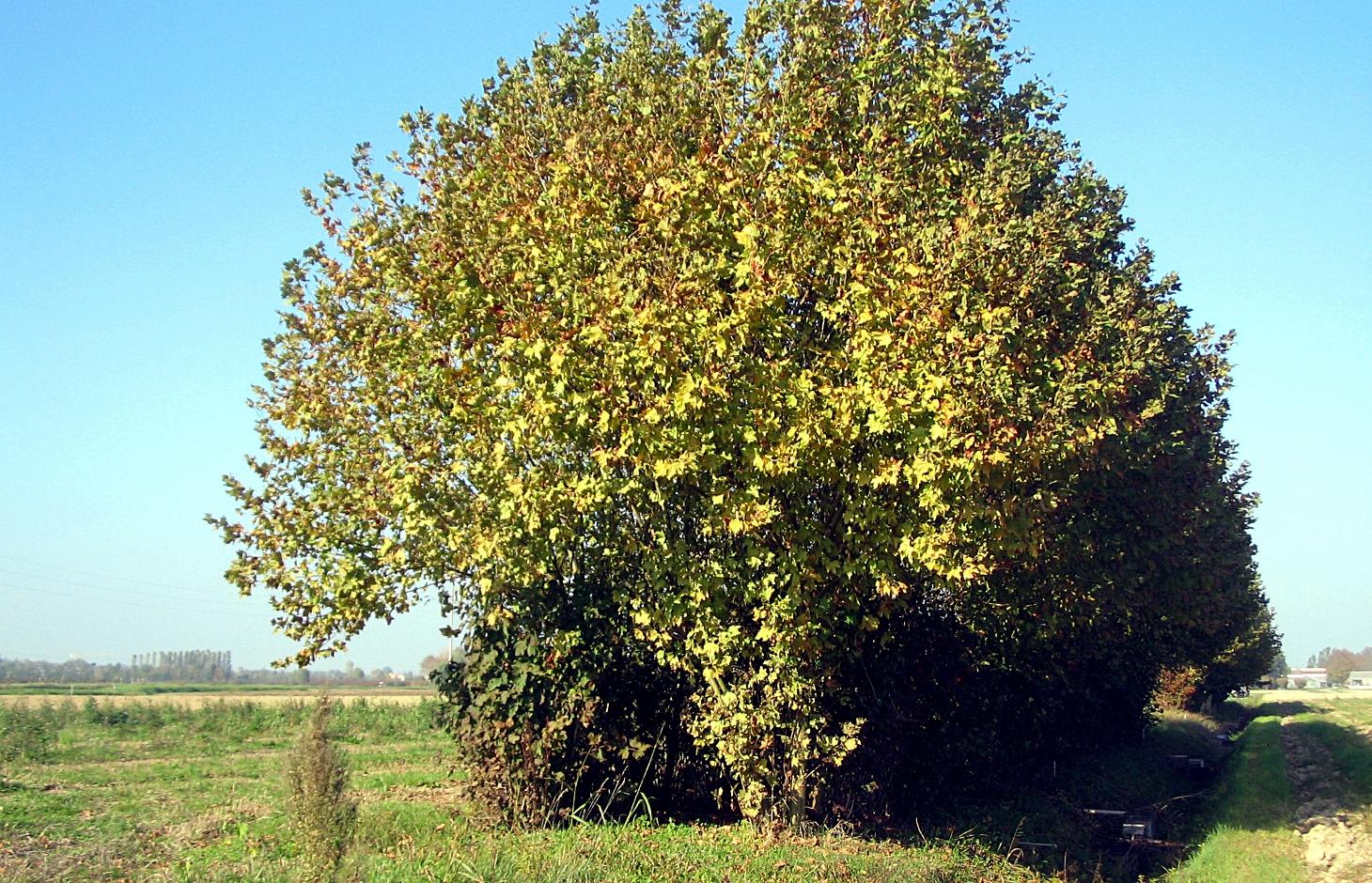
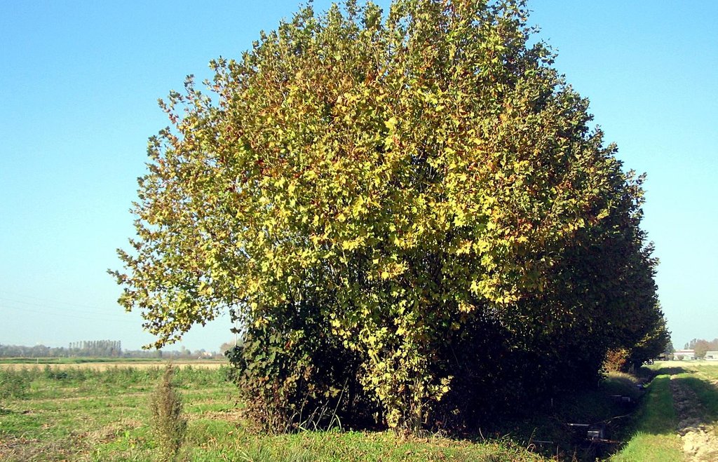
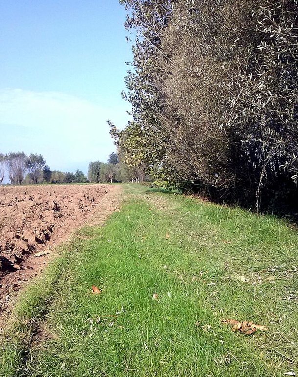
Vegetated buffer strips are agricultural areas with permanent vegetation designed to prevent surface water pollution and minimize soil erosion. In the Veneto region they are generally used along streams, canals and roads and can be composed of grass, hedges, trees or their combination. Buffer strips were a major component of agricultural landscape that has been replaced by intensive monoculture practices by increasing tillable areas. In recent years, the re-introduction of buffer zones in the Venetian plain (and generally in the whole territory of the region) has been supported as an agri-environmental measure for a sustainable land management.
Purpose of the Technology: Vegetated buffer strips, recently promoted by the regional government, are an efficient and economical way to improve surface water quality by agricultural nonpoint source pollution. Farmers take advantage of using buffer strips to help control soil erosion and sediment loss, stabilize riverbanks and reduce flood damage to crops. The continuous soil cover and diversification of habitats improve agroecosystem biodiversity and diversification of farmers income.
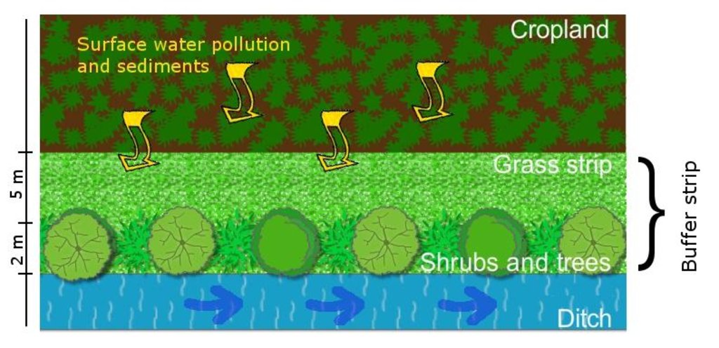
Establishment / maintenance activities and inputs: Vegetated buffer strips are generally composed of a shrub or tree belt of 1 m combined with an herbaceous band of 5 m, usually placed on the sides of cultivated fields in order to maximise their depuration efficacy as well as ensure crop production. Their function to reduce water pollution is optimal if arranged along a water course in order to intercept suspended solids and sediment-bound nutrients.
Natural / human environment: Adopting vegetated buffer strips achieves several environmental benefits with a low initial economic investment. The agroecosystem biodiversity is improved by the creation of continuous buffers that provide food, nesting cover, shaded environment and connecting corridors from one habitat to another to wildlife species, while the continuous soil cover with herbaceous and woody plants enhances soil protection and below-ground biodiversity. Water resources benefit from reduced nutrient supply and sediments that cause excessive growth of algae and diminish oxygen level of the water. Vegetated buffer strips, thanks to the maintenance and differentiation of species in the territory, enhance the quality of life through the improvement of agricultural landscape.
2.3 صور التقنية
2.5 البلد/المنطقة/المواقع التي تم تنفيذ التقنية فيها والتي يغطيها هذا التقييم
البلد:
إيطاليا
المنطقة/الولاية/المحافظة:
Italy
مزيد من التفاصيل حول الموقع:
Veneto region
2.6 تاريخ التنفيذ
في حالة عدم معرفة السنة بالتحديد، يرجى الإشارة إلى التاريخ التقريبي:
- منذ 10-50 سنة
2.7 إدخال التقنية
حدد كيف تم إدخال التقنية:
- أثناء التجارب/الأبحاث
3. تصنيف تقنية الإدارة المستدامي للأراضي
3.1 الغرض الرئيسي ( الأغراض الرئيسية) للتقنية
- الحد من تدهور الأراضي ومنعه وعكسه
3.2 نوع (أنواع) استخدام الأراضي الحالية حيث يتم تطبيق التقنية

الأراضي الزراعية
- زراعة سنوية
المحاصيل الرئيسية (المحاصيل النقدية والغذائية):
Major cash crop: Maize
Other crops: Wheat, soybean
التعليقات:
Major land use problems (compiler’s opinion): Soils in the low Venetian plain of the Veneto region generally suffer from a loss of soil organic matter (SOM) that is strongly affected by their natural texture and climatic conditions. Moreover, in the last 50 years intensive tillage practices contributed to a further SOM decrease, estimated at 0.02-0.58 t/ha/y of carbon. The introduction of monoculture worsened the agro-ecosystem habitats and reduced soil biodiversity.
Major land use problems (land users’ perception): Decrease of productivity and the need of higher inputs of fertiliser.
3.3 مزيد من المعلومات حول استخدام الأراضي
إمدادات المياه للأرض التي يتم تنفيذ التقنية عليها:
- مختلط بعلي-مروي
التعليقات:
Water supply: rainfed, full irrigation
عدد مواسم الزراعة في السنة:
- 1
حدد:
Longest growing period in days: 210 Longest growing period from month to month: March to OctoberSecond longest growing period in days: 180
3.4 مجموعةالإدارة المستدامة للأراضي التي تنتمي إليها هذه التقنية
- التدابير المتقاطعة للمنحدرات
3.5 انتشار التقنية
حدد انتشار التقنية:
- منتشرة بالتساوي على مساحة
إذا كانت التقنية منتشرة بالتساوي على منطقة ما، فحدد المنطقة التقريبية المغطاة:
- 1,000-100 كم2
3.6 التدابير التقنية في مجال إلادارة المستدامة للأراضي

التدابير النباتية
- V1: غطاء من الأشجار والشجيرات
التعليقات:
Main measures: vegetative measures
Type of vegetative measures: aligned: -linear
3.7 الأنواع الرئيسية من تدهور الأراضي التي تناولتها التقنية

تآكل التربة بالمياه
- الوزن(Wt): فقدان التربة السطحية/تآكل السطح
- (Wr):انجراف ضفة النهر

التدهور البيولوجي
- (Bh): فقدان الموائل

تدهور المياه
- (Hp): تدهور نوعية المياه السطحية
التعليقات:
Main type of degradation addressed: Wr: riverbank erosion, Bh: loss of habitats, Hp: decline of surface water quality
Secondary types of degradation addressed: Wt: loss of topsoil / surface erosion
Main causes of degradation: soil management (lack of organic input with fertilizations), population pressure (High demand for agricultural products and competition for land in densely populated area)
Secondary causes of degradation: crop management (annual, perennial, tree/shrub) (crop monoculture instead of crop rotation), deforestation / removal of natural vegetation (incl. forest fires) (mechanisation)
3.8 منع أو حد أو عكس تدهور الأراضي
تحديد هدف التقنية فيما يتعلق بتدهور الأراضي:
- منع تدهور الأراضي
- الحد من تدهور الأراضي
التعليقات:
Main goals: prevention of land degradation
Secondary goals: mitigation / reduction of land degradation
4. المواصفات الفنية، وأنشطة التنفيذ، والمدخلات، والتكاليف
4.1 الرسم الفني للتقنية
4.2 المواصفات الفنية/شروحات الرسم الفني
An interposed area between the cropland and a water course is designed to intercept runoff and reduce surface water pollution (suspended solids, nutrients etc.).
Location: Veneto region
Technical knowledge required for field staff / advisors: moderate
Technical knowledge required for land users: moderate
Main technical functions: control of dispersed runoff: retain / trap, control of dispersed runoff: impede / retard, stabilisation of soil (eg by tree roots against land slides), improvement of water quality, buffering / filtering water, sediment retention / trapping, sediment harvesting, spatial arrangement and diversification of land use
Secondary technical functions: control of concentrated runoff: retain / trap, control of concentrated runoff: impede / retard, improvement of ground cover, increase of surface roughness, increase in organic matter, increase in nutrient availability (supply, recycling,…)
Aligned: -linear
Vegetative material: T : trees / shrubs
Spacing between rows / strips / blocks (m): 3-5
Vertical interval within rows / strips / blocks (m): 1-3
Trees/ shrubs species: oak, maple, hornbeam, willow, etc.
Grass species: mixed species
4.3 معلومات عامة بخصوص حساب المدخلات والتكاليف
عملة أخرى/ عملة وطنية (حدد):
Euro €
أشر إلى سعر الصرف من الدولار الأمريكي إلى العملة المحلية (إذا كان ذا صلة): 1 دولار أمريكي =:
0,8
اذكر متوسط تكلفة أجر العمالة المستأجرة في اليوم الواحد:
21.00
4.4 أنشطة التأسيس
| النشاط | نوع التدبير | التوقيت | |
|---|---|---|---|
| 1. | Planning, mulching, soli preparation, fertilisation | نباتية | |
| 2. | Purchase of seedlings and planting | نباتية | |
| 3. | Grass strip establishment | نباتية | |
| 4. | Machinery for mowing, pruning | نباتية |
4.5 التكاليف والمدخلات اللازمة للتأسيس
| تحديد المدخلات | الوحدة | الكمية | التكاليف لكل وحدة | إجمالي التكاليف لكل مدخل | % من التكاليف التي يتحملها مستخدمو الأراضي | |
|---|---|---|---|---|---|---|
| العمالة | Planning, mulching, soli preparation, fertilisation | ha | 1,0 | 306,0 | 306,0 | |
| العمالة | Planting | ha | 1,0 | 2,5 | 2,5 | |
| العمالة | Grass strip establishment | ha | 1,0 | 152,0 | 152,0 | |
| معدات | Machinery for mowing, pruning | ha | 1,0 | 4000,0 | 4000,0 | |
| المواد النباتية | Seedlings | ha | 1,0 | 119,0 | 119,0 | |
| الأسمدة والمبيدات الحيوية | Fertilizer | ha | 1,0 | 14,0 | 14,0 | |
| إجمالي تكاليف إنشاء التقنية | 4593,5 | |||||
4.6 الصيانة/الأنشطة المتكررة
| النشاط | نوع التدبير | التوقيت/الوتيرة | |
|---|---|---|---|
| 1. | Pruning, replanting, additional irrigation | نباتية | |
| 2. | Grass strip maintenance | نباتية |
4.7 التكاليف والمدخلات اللازمة للصيانة/للأنشطة المتكررة (سنويًا)
| تحديد المدخلات | الوحدة | الكمية | التكاليف لكل وحدة | إجمالي التكاليف لكل مدخل | % من التكاليف التي يتحملها مستخدمو الأراضي | |
|---|---|---|---|---|---|---|
| العمالة | Pruning, replanting, additional irrigation | ha | 1,0 | 127,0 | 127,0 | |
| العمالة | Grass strip maintenance | ha | 1,0 | 127,0 | 127,0 | |
| إجمالي تكاليف صيانة التقنية | 254,0 | |||||
4.8 أهم العوامل المؤثرة على التكاليف
قدم وصفا لأهم العوامل التي تؤثر على التكاليف:
Establishment costs (purchase of seedlings and planting) are the most important. After the establishment of buffer strip, costs are less relevant due to little work required for maintenance.
5. البيئة الطبيعية والبشرية
5.1 المناخ
هطول الأمطار السنوي
- < 250 مم
- 251- 500 ملم
- 501 - 750ملم
- 1,000-751 ملم
- 1,500-1,100 ملم
- 2,000-1,500 ملم
- 3,000-2,001 ملم
- 4,000-3,100 ملم
- > 4000 ملم
المنطقة المناخية الزراعية
- شبه رطبة
Thermal climate class: temperate
5.2 طوبوغرافيا
متوسط الانحدارات:
- مسطح (0-2%)
- بسيط (3-5%)
- معتدل (6-10%)
- متدحرج (11-15%)
- تلال (16-30%)
- شديدة الانحدار(31-60%)
- فائقة الانحدار (>60%)
التضاريس:
- هضاب/سهول
- أثلام مرتفعة
- المنحدرات الجبلية
- منحدرات التلال
- منحدرات في السفوح
- قاع الوادي
المنطقة الارتفاعية:
- 100-0 متر فوق سطح البحر
- 500-101 متر فوق سطح البحر
- 1,000-501 متر فوق سطح البحر
- 1,500-1,001 متر فوق سطح البحر
- 2,000-1,501 متر فوق سطح البحر
- 2,500-2,100 متر فوق سطح البحر
- 3,000-2,501 متر فوق سطح البحر
- 4,000-3,001 متر فوق سطح البحر
- > 4000 متر فوق سطح البحر
5.3 التربة
متوسط عمق التربة:
- ضحل جدًا (0-20 سم)
- ضحلة (21-50 سم)
- متوسطة العمق (51-80 سم)
- عميقة (81-120 سم)
- عميقة جدًا (> 120 سم)
قوام التربة (التربة السطحية):
- خشن / خفيف (رملي)
- متوسط ( طميي، سلتي)
المواد العضوية في التربة السطحية:
- متوسطة (1-3%)
- منخفضة (<1%)
إذا كان متاحًا، قم بإرفاق وصف كامل للتربة أو تحديد المعلومات المتوفرة، على سبيل المثال نوع التربة، الرقم الهيدروجيني/ درجة حموضة التربة، قدرة التبادل الكاتيوني، النيتروجين، الملوحة وما إلى ذلك.
Soil fertility is low-medium
Soil drainage/infiltration is medium
Soil water storage capacity is medium
5.4 توافر المياه ونوعيتها
منسوب المياه الجوفية:
< 5 م
توافر المياه السطحية:
جيد
نوعية المياه (غير المعالجة):
مياه شرب جيدة
تعليقات ومواصفات أخرى بشأن نوعية المياه وكميتها:
Ground water table: <5m a.s.l. (The area surrounding the Venice lagoon (1240 km2) is even below the sea level (down to -2 m) and currently cultivated due to land reclamation. As a result water table is kept artificially low)
Water quality (untreted): Good drinking water (groundwater) and for agricultural use only (surface water can be used for agricultural purposes but not as drinking water)
5.5 التنوع البيولوجي
تنوع الأنواع:
- متوسط
التعليقات والمواصفات الإضافية بشأن التنوع البيولوجي:
High population density, infrastructures and intensive agriculture practices affect the state of biodiversity.
5.6 خصائص مستخدمي الأراضي الذين يطبقون التقنية
التوجه السوقي لنظام الإنتاج:
- تجاري/سوق
الدخل من خارج المزرعة:
- 10-50% من جميع الإيرادات
المستوى النسبي للثروة:
- متوسط
أفراداً أو مجموعات:
- فرد/أسرة معيشية
مستوى المكننة:
- ميكانيكية/ مزودة بمحرك
الجنس:
- رجال
اذكر الخصائص الأخرى ذات الصلة لمستخدمي الأراضي:
Land users applying the Technology are mainly common / average land users
Difference in the involvement of women and men: Farmers in the Veneto region are traditionally males due to historical and cultural reasons.
Population density: 200-500 persons/km2
Annual population growth: 0.5% - 1%
5.7 متوسط مساحة الأرض المملوكة أو المستأجرة من قبل مستخدمي الأراضي الذين يطبقون التقنية
- < 0.5 هكتارا
- 0.5 - 1 هكتار
- 1 -2 هكتار
- 2 - 5 هكتار
- 5 - 15 هكتار
- 15 - 50 هكتار
- 50 - 100هكتار
- 500-100 هكتار
- 1,000-500 هكتار
- 10,000-1,000 هكتار
- > 10,000 هكتار
هل يعتبر هذا نطاقًا صغيرًا أو متوسطًا أو واسعا (في إشارة إلى السياق المحلي)؟:
- على نطاق صغير
5.8 ملكية الأراضي، وحقوق استخدام الأراضي، وحقوق استخدام المياه
حقوق استخدام الأراضي:
- فردي
5.9 الوصول إلى الخدمات والبنية التحتية
الصحة:
- ضعيف
- معتدل
- جيد
التعليم:
- ضعيف
- معتدل
- جيد
المساعدة التقنية:
- ضعيف
- معتدل
- جيد
العمل (على سبيل المثال خارج المزرعة):
- ضعيف
- معتدل
- جيد
الأسواق:
- ضعيف
- معتدل
- جيد
الطاقة:
- ضعيف
- معتدل
- جيد
الطرق والنقل:
- ضعيف
- معتدل
- جيد
مياه الشرب وخدمات الصرف الصحي:
- ضعيف
- معتدل
- جيد
الخدمات المالية:
- ضعيف
- معتدل
- جيد
6. الآثار والتصريحات الختامية
6.1 الآثار التي أظهرتها التقنية في الموقع
الآثار الاجتماعية والاقتصادية
الإنتاج
إنتاج المحاصيل
إنتاج الخشب
الكمية قبل الإدارة المستدامة للأراضي:
0 t/100 linear metres
الكمية بعد الإدارة المستدامة للأراضي:
1-1.5/100 linear metres
تنوع المنتج
توافر المياه ونوعيتها
توافر مياه الشرب
الدخل والتكاليف
تنوع مصادر الدخل
الآثار الاجتماعية والثقافية
الفرص الثقافية
الفرص الترفيهية
التخفيف من حدة الصراع
الآثار الايكولوجية
دورة المياه / الجريان السطحي
جودة المياه
الجريان السطحي
التربة
غطاء التربة
فقدان التربة
دورة المغذيات/إعادة الشحن
التنوع البيولوجي: الغطاء النباتي، الحيوانات
الكتلة الحيوية/ طبقة الكربون فوق التربة
التنوع النباتي
تنوع الموائل
6.2 الآثار التي أظهرتها التقنية خارج الموقع
توافر المياه
الفيضان في اتجاه مجرى النهر
تلوث المياه الجوفية/الأنهار
القدرة على التخفيف / الترشيح
الأضرار التي لحقت بحقول الجيران
6.3 تعرض التقنية وحساسيتها لتغير المناخ التدريجي والظواهر المتطرفة/الكوارث المرتبطة بالمناخ (كما يراها مستخدمو الأراضي)
تغير مناخ تدريجي
تغير مناخ تدريجي
| الموسم | نوع التغير المناخي/ المتطرف | كيف تتعامل التقنية مع ذلك؟ | |
|---|---|---|---|
| درجة الحرارة السنوية | زيادة | جيدا |
الظواهر المتطرفة / الكوارث المرتبطة بالمناخ
الكوارث الجوية
| كيف تتعامل التقنية مع ذلك؟ | |
|---|---|
| عاصفة ممطرة محلية | جيدا |
الكوارث المناخية
| كيف تتعامل التقنية مع ذلك؟ | |
|---|---|
| جفاف | ليس جيدا |
6.4 تحليل التكلفة والعائد
كيف يمكن مقارنة العوائد نسبة لتكاليف الإنشاء (من وجهة نظر مستخدمي الأراضي)؟
عوائد قصيرة الأجل:
سلبي قليلا
عوائد طويلة الأجل:
إيجابي
كيف تتم مقارنة العوائدمع كلفة الصيانة/التكاليف المتكررة (من وجهة نظر مستخدمي الأراضي)؟
عوائد قصيرة الأجل:
إيجابي
عوائد طويلة الأجل:
إيجابي
6.5 اعتماد التقنية
من بين جميع الذين تبنوا التقنية، كم عدد الذين فعلوا ذلك بشكل تلقائي، أي دون تلقي أي حوافز مادية/مدفوعات؟:
- 90-50%
التعليقات:
50% of land user families have adopted the Technology with external material support
Comments on acceptance with external material support: On average it was estimated that, among farmers adopting the technology, ca. half of them benefited of incentives.
50% of land user families have adopted the Technology without any external material support
Comments on spontaneous adoption: On average it was estimated that, among farmers adopting the technology, ca. half of them benefited of incentives.
6.7 نقاط القوة / المزايا / الفرص التي توفرها التقنية
| نقاط القوة/ المزايا/ الفرص من وجهة نظر جامع المعلومات أو غيره من الاشخاص الرئيسيين لمصدر المعلومات |
|---|
|
protects soil from water erosion How can they be sustained / enhanced? long-term maintenance of buffer zones and soil cover |
|
protects surface water quality How can they be sustained / enhanced? combination with other sustainable technologies (e.g. reduction of pesticides). Spread over larger areas |
|
enhances agro-ecosystem biodiversity How can they be sustained / enhanced? improvement of connecting corridors between habitats |
|
diversifies farmer's production How can they be sustained / enhanced? improve farmers' education |
|
little costs compared to environmenmtal benefits How can they be sustained / enhanced? support farmers on decision making |
6.8 نقاط ضعف / مساوىء / مخاطر التقنية وسبل التغلب عليها
| نقاط الضعف/ المساوىء/ المخاطر من وجهة نظر مستخدم الأراضي | كيف يمكن التغلب عليها؟ |
|---|---|
| sometimes difficult to adjust crop production requirements with buffer strip occupation of space | support farmers on decision making |
| نقاط الضعف/ المساوىء/ المخاطر من وجهة نظر جامع المعلومات أو غيره من الاشخاص الرئيسيين لمصدر المعلومات | كيف يمكن التغلب عليها؟ |
|---|---|
| time-dependent buffer performance | Monitoring saturation-effect conditions in the medium, long-term |
| low efficacy if the technology is maintained in the short-term | improve effectiveness of subsidies to keep the technology in the long-term; increase farmers awareness on soil and water benefits |
7. المراجع والروابط
7.2 المراجع للمنشورات المتاحة
العنوان، المؤلف، السنة، النظام القياسي الدولي لترقيم الكتب ISBN:
Programma di sviluppo rurale per il veneto 2007-2013, Regione Veneto, 2007. Dipartimento Agricoltura e Sviluppo Rurale.
الروابط والوحدات المواضيعية
توسيع الكل طي الكلالروابط

Rural development programme in the Veneto region [إيطاليا]
Developing rural areas in the Veneto region through sustainable land management policies
- جامع المعلومات: Nicola Dal Ferro
الوحدات المواضيعية
لا يوجد وحدات مواضيعية


