creation of meliorative plantings for struggle with erosion [كازاخستان]
- تاريخ الإنشاء:
- تحديث:
- جامع المعلومات: Vladimir Kaverin
- المحرر: Hayot Ibrakhimov
- المراجعون: David Streiff, Alexandra Gavilano, Rima Mekdaschi Studer
no
technologies_1482 - كازاخستان
عرض الأقسام
توسيع الكل طي الكل1. معلومات عامة
1.2 تفاصيل الاتصال بالأشخاص الرئيسيين لمصدر المعلومات والمؤسسات المشاركة في تقييم وتوثيق التقنية
متخصص في الإدارة المستدامة للأراضي:
Salimov Abdul-Bari
SPC for forest facility
كازاخستان
اسم المؤسسة (المؤسسات) التي سهلت توثيق/تقييم التقنية (إذا كان ذلك على صلة)
SPC of Forest Facility (SPC of Forest Facility) - كازاخستان1.3 الشروط المتعلقة باستخدام البيانات الموثقة من خلال WOCAT
يوافق جامع المعلومات والشخص (لاشخاص) الرئيسي لمصدر المعلومات على الشروط المتعلقة باستخدام البيانات الموثقة من خلال WOCAT:
نعم
1.5 الإشارة إلى الاستبيان (الاستبيانات) حول مناهج الإدارة المستدامة للأراضي (موثقة باستخدام WOCAT)
The approach of groove fastening sandy loam and … [كازاخستان]
The approach of groove fastening sandy-loam and sandy soils of the Aral sea's drained bottom
- جامع المعلومات: Vladimir Kaverin
2. وصف تقنيةالإدارة المستدامي للأراضي
2.1 وصف مختصر للتقنية
تعريف التقنية:
Technology of creation of meliorative plantings for struggle against wind and water erosion
2.2 وصف تفصيلي للتقنية
الوصف:
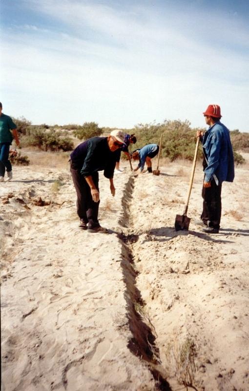
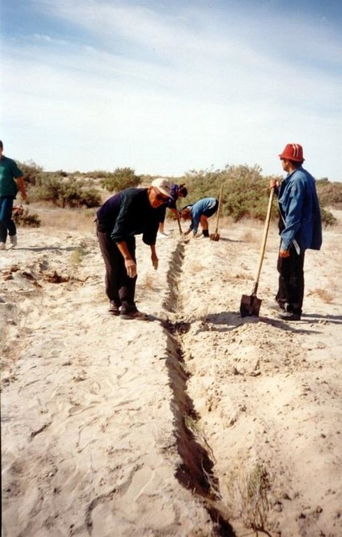
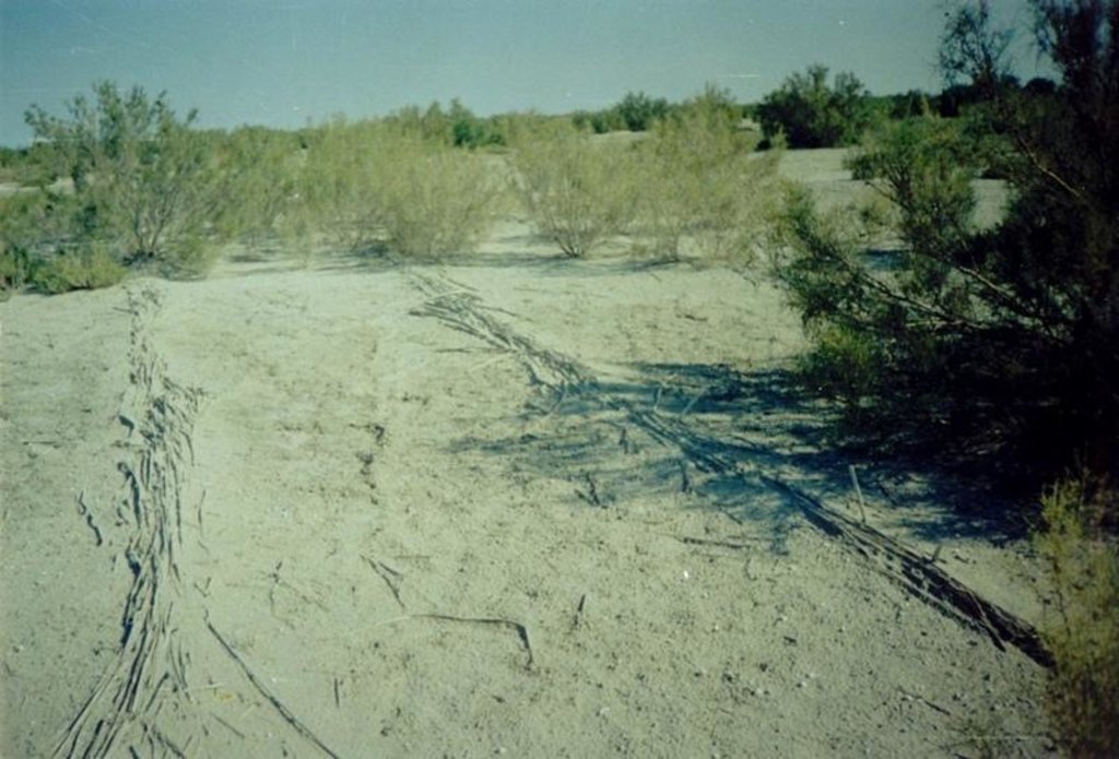
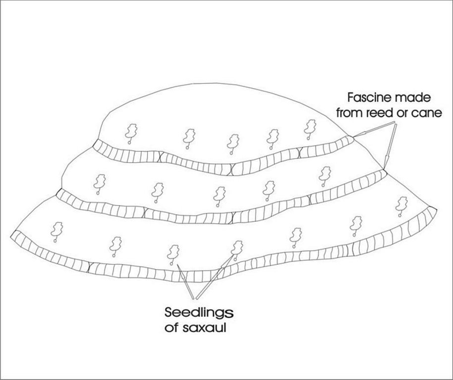
In Syrdarya river’s delta on alluvial drought sandy and loam sand soils processes of wind and water erosion become more active with a view of protection of the soils it is applied covering fascine made from a local cane or reed. Fascines thickness 12-15 cm settle down on a surface by lines in a 2-3 m. On distance of 20 centimeters it is carried out planting of a saxaul seedlings
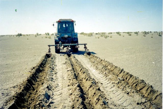
-Planting of the saplings was done in holes and uninterrupted furrows, which were formed by hands.
-Depth of holes and furrows is 20-25 cm.
-Distance between holes was 1.5-2 m.
-Furrows were perpendicular to the prevailing winds (west-east) and placing mould in several optio0ns: 1- moulds on both sides; 2- the same from the southern side of a furrow; 3- the same from the northern side. Furrows alternated with holes rows.
-Length of rows variants in repetition was 100 m.
-Saplings were filled up by hands in rows in 1-2 meters, distance between rows was 2-2.5 meters.
Prevention of water and wind erosion on sandy and loamy sand soils of the Syrdarya delta.
Many farmers use the given technology for prevention of wind and water erosion on the lands.
The technology is applied on the area of 1.5 sq.km. Expenses per 1 ha make 99.2 $ USA or 14880 tenge.
Irrevocable water consumption in agricultural land use in the Syrdarya delta, development of the areas of irrigation, livestock grazing led to the contradiction between the agricultural industry and the ecological state of the region. It caused more intense processes of desertification, among them are soil salification and increase in the groundwater mineralization: degradation of vegetation cover; erosion and soil deflation; wind-blowing of the salts from dried bed of the Aral Sea; sand advance on the arable land, etc. At present about of 60% of irrigated areas within the Syrdarya delta are strongly salificated.
2.3 صور التقنية
2.5 البلد/المنطقة/المواقع التي تم تنفيذ التقنية فيها والتي يغطيها هذا التقييم
البلد:
كازاخستان
المنطقة/الولاية/المحافظة:
Kyzylorda oblast
مزيد من التفاصيل حول الموقع:
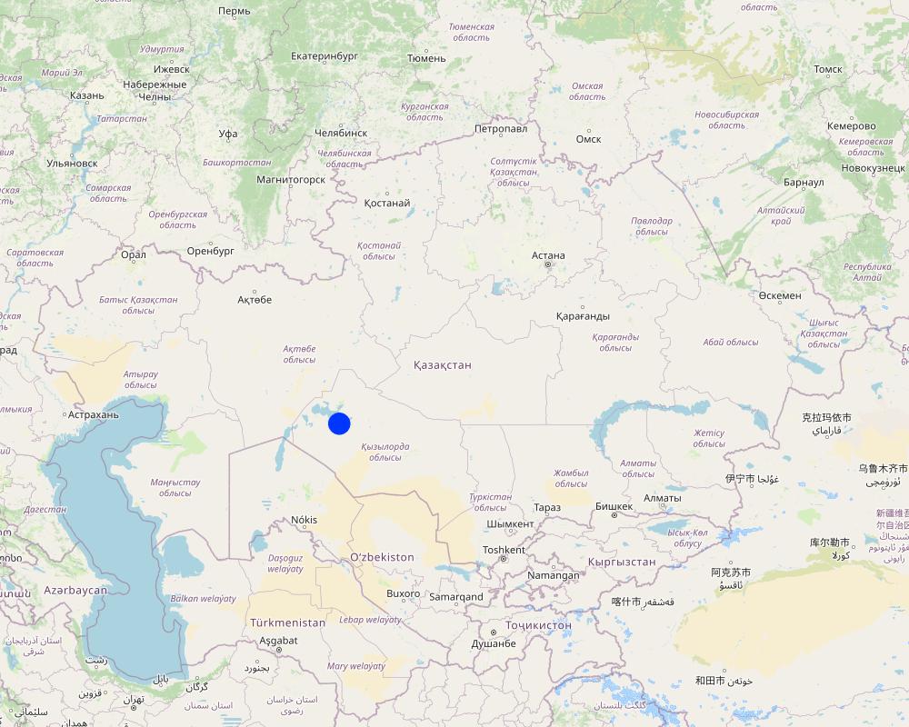
Kazalinsk
حدد انتشار التقنية:
- منتشرة بالتساوي على مساحة
إذا كانت التقنيةا موزعة بالتساوي على منطقة ما، حدد المساحة المغطاة (بالكيلومتر المربع):
3,5
إذا كانت المساحة الدقيقة غير معروفة، فيرجى الإشارة إلى المنطقة التقريبية المغطاة:
- 10-1 كم2
التعليقات:
Total area covered by the SLM Technology is 3.5 km2.
Loamy sand and sandy alluvial desertification soils of delta of the river Syrdarya are subject to process of wind erosion Deflation-accumulative prosses create threat for settlement
Map
×2.6 تاريخ التنفيذ
في حالة عدم معرفة السنة بالتحديد، يرجى الإشارة إلى التاريخ التقريبي:
- منذ أقل من 10 سنوات (مؤخرًا)
2.7 إدخال التقنية
حدد كيف تم إدخال التقنية:
- أثناء التجارب/الأبحاث
التعليقات (نوع المشروع، الخ):
From Kazakh Research Institute of forest management at 1989-2002
3. تصنيف تقنية الإدارة المستدامي للأراضي
3.1 الغرض الرئيسي ( الأغراض الرئيسية) للتقنية
- الحد من تدهور الأراضي ومنعه وعكسه
- الحد من مخاطر الكوارث
3.2 نوع (أنواع) استخدام الأراضي الحالية حيث يتم تطبيق التقنية
استخدامات الأراضي مختلطة ضمن نفس وحدة الأرض:
نعم
حدد استخدام الأراضي المختلطة (المحاصيل / الرعي / الأشجار):
- الرعي الزراعي الحرجي

الأراضي الزراعية
- زراعة سنوية
- زراعة الأشجار والشجيرات
الزراعة السنوية - حدد المحاصيل:
- الحبوب - الذرة
- الحبوب - الأرز (في الأراضي المرتفعة)
زراعة الأشجار والشجيرات -حدد المحاصيل:
- أشجار العلف (كالياندرا، لوسينا، المسكيت، إلخ.)
- Saxaul (cf. Haloxylon ammodendron)
عدد مواسم الزراعة في السنة:
- 2
حدد:
Longest growing period in days: 208; Longest growing period from month to month: Apr - Oct

أراضي الرعي
الرعي الواسع النطاق:
- رعي شبه مرتحل

الغابات/ الأراضي الحرجية
منتجات وخدمات:
- حطب الوقود
التعليقات:
Trees/ shrubs species: saxaul seedling
Grass species: prostrate summer cypress, winterfat, corn
Major land use problems (compiler’s opinion): Loss of biological variety, degrodation of lands for agriculturing
Major land use problems (land users’ perception): Approach of sand to settlements and agricultural grounds
Grazingland comments: With a transitional economy and absence of market relations it is prevail a fine farms with a small amount of cattle on a farmstead
Type of grazing system comments: With a transitional economy and absence of market relations it is prevail a fine farms with a small amount of cattle on a farmstead
Constraints of mines and extractive industries: old system of landed property
Livestock in deltoid meadows
3.4 إمدادات المياه
إمدادات المياه للأرض التي يتم تنفيذ التقنية عليها:
- بعلية
3.5 مجموعةالإدارة المستدامة للأراضي التي تنتمي إليها هذه التقنية
- مصد الريح/حزام حماية
- تحسين الغطاء الأرضي/النباتي
3.6 التدابير التقنية في مجال إلادارة المستدامة للأراضي

التدابير النباتية
- V1: غطاء من الأشجار والشجيرات

التدابير البنيوية
- S3: الخنادق المتدرجة ،والقنوات، والممرات المائية
التعليقات:
Secondary measures: structural measures
Type of vegetative measures: aligned: -against wind
3.7 الأنواع الرئيسية من تدهور الأراضي التي تناولتها التقنية

تآكل التربة بالمياه
- الوزن(Wt): فقدان التربة السطحية/تآكل السطح

تآكل التربة الناتج عن الرياح
- (Et): فقدان التربة السطحية
التعليقات:
Secondary types of degradation addressed: Wt: loss of topsoil / surface erosion
Main causes of degradation: other human induced causes (specify) (agricultural causes - Excessive water-fence on an irrigation from the rivers Syrdarya and Amurdarya.)
Secondary causes of degradation: deforestation / removal of natural vegetation (incl. forest fires) (Destraction saxaul fuel.), other natural causes (avalanches, volcanic eruptions, mud flows, highly susceptible natural resources, extreme topography, etc.) specify (High wind activity in region (prevalence of winds with a speed up to 5 min/sec).)
3.8 منع أو حد أو عكس تدهور الأراضي
تحديد هدف التقنية فيما يتعلق بتدهور الأراضي:
- منع تدهور الأراضي
- اصلاح/إعادة تأهيل الأراضي المتدهورة بشدة
4. المواصفات الفنية، وأنشطة التنفيذ، والمدخلات، والتكاليف
4.1 الرسم الفني للتقنية
المواصفات الفنية (المتعلقة بالرسم الفني):
Ameliorative plantings
Technical knowledge required for field staff / advisors: low
Technical knowledge required for land users: low
Main technical functions: reduction in wind speed
Aligned: -against wind
Vegetative material: T : trees / shrubs, G : grass
Number of plants per (ha): 3000
Vertical interval between rows / strips / blocks (m): 2
Spacing between rows / strips / blocks (m): 2
Vertical interval within rows / strips / blocks (m): 1,5
Width within rows / strips / blocks (m): 0,2
Trees/ shrubs species: saxaul seedling
Grass species: prostrate summer cypress, winterfat, corn
Dam/ pan/ pond
Vertical interval between structures (m): 2
Spacing between structures (m): 2
Height of bunds/banks/others (m): 0,05
Width of bunds/banks/others (m): 0,5
Length of bunds/banks/others (m): 100
Construction material (other): Reed fascines
4.2 معلومات عامة بخصوص حساب المدخلات والتكاليف
حدد العملة المستخدمة لحساب التكاليف:
- دولار أمريكي USD
اذكر متوسط تكلفة أجر العمالة المستأجرة في اليوم الواحد:
5.00
4.3 أنشطة التأسيس
| النشاط | التوقيت (الموسم) | |
|---|---|---|
| 1. | Stacking of fascines | summer |
| 2. | Slips' planting | autumn, spring |
| 3. | Laying fascines | summer |
| 4. | Slips' planting | spring, autumn |
4.4 التكاليف والمدخلات اللازمة للتأسيس
| تحديد المدخلات | الوحدة | الكمية | التكاليف لكل وحدة | إجمالي التكاليف لكل مدخل | % من التكاليف التي يتحملها مستخدمو الأراضي | |
|---|---|---|---|---|---|---|
| العمالة | Labour | persons/day/ha | 3,0 | 5,0 | 15,0 | 100,0 |
| معدات | Machine use | ha | 1,0 | 20,0 | 20,0 | 100,0 |
| معدات | Tools | ha | 1,0 | 10,0 | 10,0 | 100,0 |
| المواد النباتية | Seedlings | ha | 1,0 | 165,0 | 165,0 | 100,0 |
| مواد البناء | Other | ha | 1,0 | 10,0 | 10,0 | 100,0 |
| إجمالي تكاليف إنشاء التقنية | 220,0 | |||||
| إجمالي تكاليف إنشاء التقنية بالدولار الأمريكي | 220,0 | |||||
التعليقات:
Duration of establishment phase: 24 month(s)
4.5 الصيانة/الأنشطة المتكررة
| النشاط | التوقيت/الوتيرة | |
|---|---|---|
| 1. | Additional planting | spring /1 |
| 2. | Supplementary slips' planting | spring, autumn/1 |
| 3. | Supplementary fascines' setting | spring, autumn/1 |
4.6 التكاليف والمدخلات اللازمة للصيانة/للأنشطة المتكررة (سنويًا)
التعليقات:
Reed fascines against deflation 100 m in length, 0,5 m in breadth 50 pieces per ha
Saxaul’s seedling every 2 m lines, distance between slips-1.5 m, 3300 pieces per ha
4.7 أهم العوامل المؤثرة على التكاليف
قدم وصفا لأهم العوامل التي تؤثر على التكاليف:
Manufacturing of reed fascines, purchase and planting saxaul's seedlinfs
5. البيئة الطبيعية والبشرية
5.1 المناخ
هطول الأمطار السنوي
- < 250 مم
- 251- 500 ملم
- 501 - 750ملم
- 1,000-751 ملم
- 1,500-1,100 ملم
- 2,000-1,500 ملم
- 3,000-2,001 ملم
- 4,000-3,100 ملم
- > 4000 ملم
حدد متوسط هطول الأمطار السنوي (إذا كان معروفًا)، بالملليمتر:
124,00
المنطقة المناخية الزراعية
- قاحلة
Deserted
5.2 طوبوغرافيا
متوسط الانحدارات:
- مسطح (0-2%)
- بسيط (3-5%)
- معتدل (6-10%)
- متدحرج (11-15%)
- تلال (16-30%)
- شديدة الانحدار(31-60%)
- فائقة الانحدار (>60%)
التضاريس:
- هضاب/سهول
- أثلام مرتفعة
- المنحدرات الجبلية
- منحدرات التلال
- منحدرات في السفوح
- قاع الوادي
المنطقة الارتفاعية:
- 100-0 متر فوق سطح البحر
- 500-101 متر فوق سطح البحر
- 1,000-501 متر فوق سطح البحر
- 1,500-1,001 متر فوق سطح البحر
- 2,000-1,501 متر فوق سطح البحر
- 2,500-2,100 متر فوق سطح البحر
- 3,000-2,501 متر فوق سطح البحر
- 4,000-3,001 متر فوق سطح البحر
- > 4000 متر فوق سطح البحر
التعليقات والمواصفات الإضافية بشأن التضاريس:
Altitudinal zone: 58-53 m abs. of hight
Landforms: Poorly wavy inclined plan
Slopes on average: Weakly wavy
5.3 التربة
متوسط عمق التربة:
- ضحل جدًا (0-20 سم)
- ضحلة (21-50 سم)
- متوسطة العمق (51-80 سم)
- عميقة (81-120 سم)
- عميقة جدًا (> 120 سم)
قوام التربة (التربة السطحية):
- خشن / خفيف (رملي)
- متوسط ( طميي، سلتي)
المواد العضوية في التربة السطحية:
- منخفضة (<1%)
إذا كان متاحًا، قم بإرفاق وصف كامل للتربة أو تحديد المعلومات المتوفرة، على سبيل المثال نوع التربة، الرقم الهيدروجيني/ درجة حموضة التربة، قدرة التبادل الكاتيوني، النيتروجين، الملوحة وما إلى ذلك.
Soil depth on average: Depth of humus under 5sm
Soil fertility is very low 0,191 of humus
Topsoil organic matter: 0,13-0,26%
Soil drainage / infiltration is good ins sandy and loamy soils and medium in clay
Soil water storage capacity is very low - low
5.6 خصائص مستخدمي الأراضي الذين يطبقون التقنية
التوجه السوقي لنظام الإنتاج:
- مختلط (كفاف/ تجاري)
الدخل من خارج المزرعة:
- أقل من % 10من كامل الدخل
المستوى النسبي للثروة:
- ضعيف جدا
- ضعيف
مستوى المكننة:
- عمل يدوي
اذكر الخصائص الأخرى ذات الصلة لمستخدمي الأراضي:
Annual population growth: negative
20% of the land users are average wealthy and own 60% of the land.
20% of the land users are poor and own 20% of the land.
60% of the land users are poor and own 20% of the land.
Off-farm income specification: With falling a level of Aral sea and degradation of the natural invironment in dicline there came all branches of agriculture and fishing industry
Level of mechanization: Fascines and planting of bushes are manually spread
Market orientation of production system: Rise of pastures' fodder capacity
5.7 متوسط مساحة الأرض التي يستخدمها مستخدمو الأراضي الذين يطبقون التقنية
- < 0.5 هكتارا
- 0.5 - 1 هكتار
- 1 -2 هكتار
- 2 - 5 هكتار
- 5 - 15 هكتار
- 15 - 50 هكتار
- 50 - 100هكتار
- 500-100 هكتار
- 1,000-500 هكتار
- 10,000-1,000 هكتار
- > 10,000 هكتار
5.8 ملكية الأراضي، وحقوق استخدام الأراضي، وحقوق استخدام المياه
ملكية الارض:
- دولة
حقوق استخدام الأراضي:
- مجتمعي (منظم)
- فردي
6. الآثار والتصريحات الختامية
6.1 الآثار التي أظهرتها التقنية في الموقع
الآثار الاجتماعية والاقتصادية
الإنتاج
إنتاج المحاصيل
التعليقات/ حدد:
The projective covering increases
الدخل والتكاليف
دخل المزرعة
التعليقات/ حدد:
Increase in effeciency of livestock
عبء العمل
التعليقات/ حدد:
Manual labour
آثار اجتماعية واقتصادية أخرى
Fastening of surface
التعليقات/ حدد:
Stoppage of blowing
الآثار الاجتماعية والثقافية
المؤسسات المجتمعية
التعليقات/ حدد:
Increase of farmer's living level
الآثار الايكولوجية
التربة
غطاء التربة
التعليقات/ حدد:
Surface stabilization
فقدان التربة
التعليقات/ حدد:
Blowing stops
الحد من مخاطر المناخ والكوارث
سرعة الرياح
التعليقات/ حدد:
Times are occupied
الآثار الايكولوجية الأخرى
biodiversity
6.2 الآثار التي أظهرتها التقنية خارج الموقع
الرواسب المنقولة بواسطة الرياح
التعليقات/ حدد:
Erosion of surface of the ground are stopping
6.4 تحليل التكلفة والعائد
كيف يمكن مقارنة العوائد نسبة لتكاليف الإنشاء (من وجهة نظر مستخدمي الأراضي)؟
عوائد طويلة الأجل:
إيجابي قليلا
كيف تتم مقارنة العوائدمع كلفة الصيانة/التكاليف المتكررة (من وجهة نظر مستخدمي الأراضي)؟
عوائد طويلة الأجل:
إيجابي قليلا
6.5 اعتماد التقنية
- 11-50%
إذا كان متاحًا، قم بتحديد الكمية (عدد الأسر المعيشية و/أو المساحةالمغطاة):
15 households covering 20 percent of stated area
من بين جميع الذين تبنوا التقنية، كم عدد الذين فعلوا ذلك بشكل تلقائي، أي دون تلقي أي حوافز مادية/مدفوعات؟:
- 91-100%
التعليقات:
15 land user families have adopted the Technology without any external material support
Comments on spontaneous adoption: survey results
There is a moderate trend towards spontaneous adoption of the Technology
Comments on adoption trend: The increase of deflated and eroded areas compels farmers to apply SWC
6.7 نقاط القوة / المزايا / الفرص التي توفرها التقنية
| نقاط القوة/ المزايا/ الفرص من وجهة نظر مستخدمي الأراضي |
|---|
|
Decrease in the areas of wind and water erosion How can they be sustained / enhanced? For a long time enough depending on life cycle of wood-bushes vegetation |
|
Improvement of microclimatic conditions of settlements How can they be sustained / enhanced? During all time of existence of the green zone created with the help of SWC |
| نقاط القوة/ المزايا/ الفرص من وجهة نظر جامع المعلومات أو غيره من الاشخاص الرئيسيين لمصدر المعلومات |
|---|
|
Stabilization of mobile sand How can they be sustained / enhanced? At rational use of technology the created ecosystem can be supported for some life cycles with help of the main wood breed |
| Elimination of drifts of settlements by sand |
| Returning the grounds in rotation of the pasture |
| Creation of additional workplaces |
6.8 نقاط ضعف / مساوىء / مخاطر التقنية وسبل التغلب عليها
| نقاط الضعف/ المساوىء/ المخاطر من وجهة نظر مستخدم الأراضي | كيف يمكن التغلب عليها؟ |
|---|---|
| Shortage of seedlings for the big areas | Creation of artificial nurseries |
| نقاط الضعف/ المساوىء/ المخاطر من وجهة نظر جامع المعلومات أو غيره من الاشخاص الرئيسيين لمصدر المعلومات | كيف يمكن التغلب عليها؟ |
|---|---|
| Almost hundred percentage use of manual skills | Development of new machines and mechanisms |
| Probably low survival of seedlings and absence of shoots because the weather conditions are not good enough | The organization of post planting watering |
7. المراجع والروابط
7.1 طرق جمع/مصادر المعلومات
7.2 المراجع للمنشورات المتاحة
العنوان، المؤلف، السنة، النظام القياسي الدولي لترقيم الكتب ISBN:
"To develop scientific bases of forest amelioration of the grounds of a naked bottom of Aral sea, classification of types of growth conditions" Kaverin V.S.. 2000y.
متاح من أين؟كم التكلفة؟:
SPC for forest facility58 Kirov str. Shuchinsk cityAkmola regionThe Republic of Kazakhstan
الروابط والوحدات المواضيعية
توسيع الكل طي الكلالروابط

The approach of groove fastening sandy loam and … [كازاخستان]
The approach of groove fastening sandy-loam and sandy soils of the Aral sea's drained bottom
- جامع المعلومات: Vladimir Kaverin
الوحدات المواضيعية
لا يوجد وحدات مواضيعية


