creation of meliorative plantings for struggle with erosion [ប្រទេសកាហ្សាក់ស្ថាន]
- ការបង្កើត៖
- បច្ចុប្បន្នភាព
- អ្នកចងក្រង៖ Vladimir Kaverin
- អ្នកកែសម្រួល៖ –
- អ្នកត្រួតពិនិត្យច្រើនទៀត៖ David Streiff, Alexandra Gavilano
no
technologies_1482 - ប្រទេសកាហ្សាក់ស្ថាន
ពិនិត្យមើលគ្រប់ផ្នែក
ពង្រីកមើលទាំងអស់ បង្រួមទាំងអស់1. ព័ត៌មានទូទៅ
1.2 ព័ត៌មានលម្អិតពីបុគ្គលសំខាន់ៗ និងស្ថាប័នដែលចូលរួមក្នុងការវាយតម្លៃ និងចងក្រងឯកសារនៃបច្ចេកទេស
អ្នកជំនាញឯកទេស SLM:
Salimov Abdul-Bari
SPC for forest facility
ប្រទេសកាហ្សាក់ស្ថាន
ឈ្មោះអង្គភាពមួយ (ច្រើន) ដែលបានចងក្រងឯកសារ/ វាយតម្លៃបច្ចេកទេស (បើទាក់ទង)
SPC of Forest Facility (SPC of Forest Facility) - ប្រទេសកាហ្សាក់ស្ថាន1.3 លក្ខខណ្ឌទាក់ទងទៅនឹងការប្រើប្រាស់ទិន្នន័យដែលបានចងក្រងតាមរយៈ វ៉ូខេត
អ្នកចងក្រង និង(បុគ្គលសំខាន់ៗ)យល់ព្រមទទួលយកនូវលក្ខខណ្ឌនានាទាក់ទងទៅនឹងការប្រើប្រាស់ទិន្នន័យដែលបានចងក្រងតាមរយៈវ៉ូខេត:
បាទ/ចា៎
1.5 ការយោងទៅលើកម្រងបញ្ជីសំណួរ (មួយ ឬច្រើន) នៃវិធីសាស្ត្រផ្សព្វផ្សាយ SLM (ដែលបានចងក្រងដោយទស្សនៈពិភពលោកស្តីពីវិធីសាស្ត្រ និងបច្ចេកទេសងអភិរក្ស WOCAT)
The approach of groove fastening sandy loam and … [ប្រទេសកាហ្សាក់ស្ថាន]
The approach of groove fastening sandy-loam and sandy soils of the Aral sea's drained bottom
- អ្នកចងក្រង៖ Vladimir Kaverin
2. ការពណ៌នាពីបច្ចេកទេស SLM
2.1 ការពណ៌នាដោយសង្ខេបពីបច្ចេកទេស
និយមន័យបច្ចេកទេស:
Technology of creation of meliorative plantings for struggle against wind and water erosion
2.2 ការពណ៌នាលម្អិតពីបច្ចេកទេស
ការពណ៌នា:
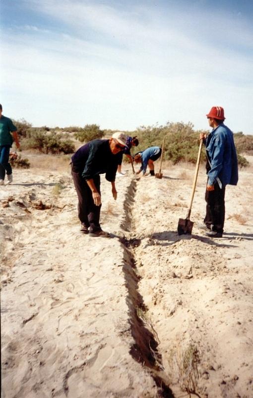
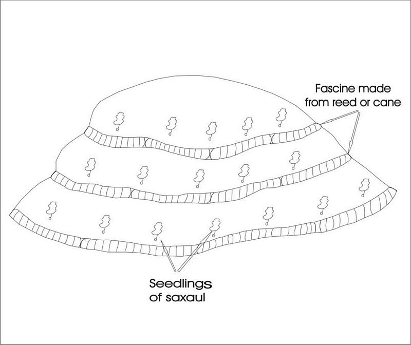
In Syrdarya river’s delta on alluvial drought sandy and loam sand soils processes of wind and water erosion become more active with a view of protection of the soils it is applied covering fascine made from a local cane or reed. Fascines thickness 12-15 cm settle down on a surface by lines in a 2-3 m. On distance of 20 centimeters it is carried out planting of a saxaul seedlings
-Planting of the saplings was done in holes and uninterrupted furrows, which were formed by hands.
-Depth of holes and furrows is 20-25 cm.
-Distance between holes was 1.5-2 m.
-Furrows were perpendicular to the prevailing winds (west-east) and placing mould in several optio0ns: 1- moulds on both sides; 2- the same from the southern side of a furrow; 3- the same from the northern side. Furrows alternated with holes rows.
-Length of rows variants in repetition was 100 m.
-Saplings were filled up by hands in rows in 1-2 meters, distance between rows was 2-2.5 meters.
Prevention of water and wind erosion on sandy and loamy sand soils of the Syrdarya delta.
Many farmers use the given technology for prevention of wind and water erosion on the lands.
The technology is applied on the area of 1.5 sq.km. Expenses per 1 ha make 99.2 $ USA or 14880 tenge.
Irrevocable water consumption in agricultural land use in the Syrdarya delta, development of the areas of irrigation, livestock grazing led to the contradiction between the agricultural industry and the ecological state of the region. It caused more intense processes of desertification, among them are soil salification and increase in the groundwater mineralization: degradation of vegetation cover; erosion and soil deflation; wind-blowing of the salts from dried bed of the Aral Sea; sand advance on the arable land, etc. At present about of 60% of irrigated areas within the Syrdarya delta are strongly salificated.
2.3 រូបភាពនៃបច្ចេកទេស
វិចិត្រសាលប្រព័ន្ធផ្សព្វផ្សាយ
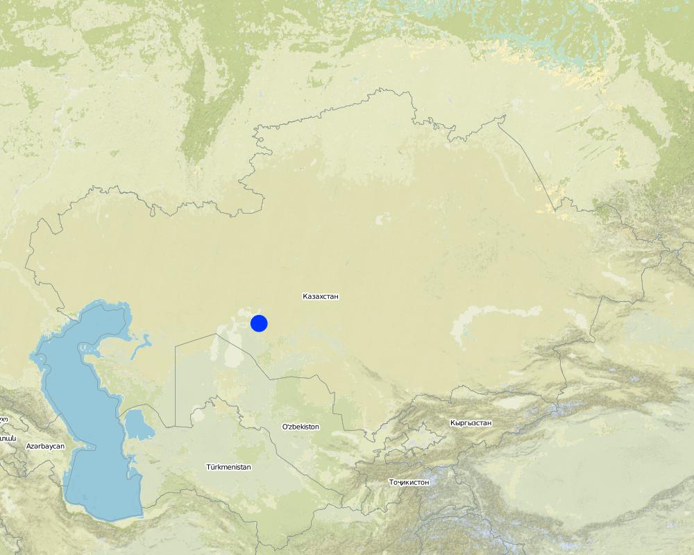
2.5 ប្រទេស/តំបន់/ទីតាំងកន្លែង ដែលបច្ចេកទេសត្រូវបានអនុវត្ត និងបានគ្រប់ដណ្តប់ដោយការវាយតម្លៃនេះ
ប្រទេស:
ប្រទេសកាហ្សាក់ស្ថាន
តំបន់/រដ្ឋ/ខេត្ត:
Kyzylorda oblast
បញ្ជាក់បន្ថែមពីលក្ខណៈនៃទីតាំង:
Kazalinsk
បញ្ជាក់ពីការសាយភាយនៃបច្ចេកទេស:
- ត្រូវបានផ្សព្វផ្សាយត្រឹមតំបន់មួយ
ប្រសិនបើបច្ចេកទេសត្រូវបានសាយភាយពាសពេញតំបន់ណាមួយ បញ្ជាក់ទំហំផ្ទៃដីអនុវត្តន៍ (គិតជា គ.ម2):
3,5
ប្រសិនបើមិនច្បាស់ពីទំហំផ្ទៃដី សូមធ្វើការប៉ាន់ប្រម៉ាណ:
- 1-10 គម2
មតិយោបល់:
Total area covered by the SLM Technology is 3.5 km2.
Loamy sand and sandy alluvial desertification soils of delta of the river Syrdarya are subject to process of wind erosion Deflation-accumulative prosses create threat for settlement
Map
×2.6 កាលបរិច្ឆេទនៃការអនុវត្ត
ប្រសិនបើមិនច្បាស់ឆ្នាំ សូមបញ្ជាក់កាលបរិច្ឆេទដែលប្រហាក់ប្រហែល:
- តិចជាង 10ឆ្នាំមុន (ថ្មី)
2.7 ការណែនាំពីបច្ចេកទេស
សូមបញ្ជាក់តើបច្ចេកទេសត្រូវបានណែនាំឱ្យអនុវត្តដោយរបៀបណា:
- ពេលកំពុងពិសោធន៍
មតិយោបល់ (ប្រភេទនៃគម្រោង ។ល។):
From Kazakh Research Institute of forest management at 1989-2002
3. ចំណាត់ថ្នាក់នៃបច្ចេកទេស SLM
3.1 គោលបំណងចម្បង (១ ឬច្រើន) នៃបច្ចេកទេសនេះ
- កាត់បន្ថយ, បង្ការ, ស្តារឡើងវិញនូវការធ្លាក់ចុះគុណភាពដី
- កាត់បន្ថយហានិភ័យនៃគ្រោះមហន្តរាយ
3.2 ប្រភេទដីប្រើប្រាស់មួយប្រភេទ (ច្រើនប្រភេទ) ដែលបានអនុវត្តបច្ចេកទេស
ដីប្រើប្រាស់ចម្រុះនៅលើដីតែមួយ:
បាទ/ចា៎
បញ្ជាក់ពីប្រភេទដីច្រើនប្រភេទ (ដីដាំដំណាំ/ដីចិញ្ចឹមសត្វ/ដីព្រៃឈើ):
- ដាំដំណាំ ចិញ្ចឹមសត្វ និងឈើ

ដីដាំដំណាំ
- ដំណាំប្រចាំឆ្នាំ
- ប្រភេទដើមឈើធំៗ និងដើមឈើតូចៗ
ដំណាំប្រចាំឆ្នាំ - បញ្ជាក់ប្រភេទដំណាំ:
- ធញ្ញជាតិ - ពោត
- ធញ្ញជាតិ - ស្រូវ (តំបន់ខ្ពង់រាប)
ប្រភេទដើមឈើធំៗ និងដើមឈើតូចៗ - បញ្ជាក់ប្រភេទ:
- ដំណាំចំណី (Calliandra, Leucaena leucocephala, Prosopis, etc.)
- Saxaul (cf. Haloxylon ammodendron)
ចំនួនសារដែលដាំដំណាំក្នុងមួយឆ្នាំ:
- 2
សូមបញ្ជាក់:
Longest growing period in days: 208; Longest growing period from month to month: Apr - Oct

ដីសម្រាប់ចិញ្ចឹមសត្វ
វាលស្មៅធំៗ:
- ពាក់កណ្តាលពនេចរ

ដីព្រៃ/ដីដាំដើមឈើ
ផលិតផល និងសេវាកម្ម:
- អុស
មតិយោបល់:
Trees/ shrubs species: saxaul seedling
Grass species: prostrate summer cypress, winterfat, corn
Major land use problems (compiler’s opinion): Loss of biological variety, degrodation of lands for agriculturing
Major land use problems (land users’ perception): Approach of sand to settlements and agricultural grounds
Grazingland comments: With a transitional economy and absence of market relations it is prevail a fine farms with a small amount of cattle on a farmstead
Type of grazing system comments: With a transitional economy and absence of market relations it is prevail a fine farms with a small amount of cattle on a farmstead
Constraints of mines and extractive industries: old system of landed property
Livestock in deltoid meadows
3.4 ការផ្គត់ផ្គង់ទឹក
ការផ្គត់ផ្គង់ទឹកនៅកន្លែងអនុវត្តបច្ចេកទេស:
- ទឹកភ្លៀង
3.5 ក្រុម SLM ដែលបច្ចេកទេសស្ថិតនៅក្នុង
- របាំងខ្យល់
- ធ្វើឱ្យប្រសើរឡើងគម្របដី/ ដំណាំគម្របដី
3.6 វិធានការ SLM ដែលបញ្ចូលនូវបច្ចេកទេស

វិធានការរុក្ខជាតិ
- V1: ឈើធំៗ និងដើមឈើតូចៗ

វិធានការរចនាស័ម្ពន្ធ
- S3: កម្ពស់ភ្លឺ ប្រឡាយ ផ្លូវទឹក
មតិយោបល់:
Secondary measures: structural measures
Type of vegetative measures: aligned: -against wind
3.7 កំណត់ប្រភេទនៃការធ្លាក់ចុះគុណភាពដីសំខាន់ៗដែលបច្ចេកទេសនេះបានដោះស្រាយ

ការហូរច្រោះដីដោយសារទឹក
- Wt: ការបាត់ដីស្រទាប់លើដោយការហូរច្រោះ

ការបាត់ដីដោយសារខ្យល់
- Et: ការបាត់បង់ដីស្រទាប់លើ
មតិយោបល់:
Secondary types of degradation addressed: Wt: loss of topsoil / surface erosion
Main causes of degradation: other human induced causes (specify) (agricultural causes - Excessive water-fence on an irrigation from the rivers Syrdarya and Amurdarya.)
Secondary causes of degradation: deforestation / removal of natural vegetation (incl. forest fires) (Destraction saxaul fuel.), other natural causes (avalanches, volcanic eruptions, mud flows, highly susceptible natural resources, extreme topography, etc.) specify (High wind activity in region (prevalence of winds with a speed up to 5 min/sec).)
3.8 ការពារ កាត់បន្ថយ ឬស្តារឡើងវិញនៃការធ្លាក់ចុះគុណភាពដី
បញ្ជាក់ពីគោលដៅរបស់បច្ចេកទេស ដែលផ្តោតទៅការធ្លាក់ចុះគុណភាពដី:
- ការការពារការធ្លាក់ចុះគុណភាពដី
- ការជួសជុល/ ស្តារឡើងវិញនៃឱនភាពដីធ្ងន់ធ្ងរ
4. បច្ចេកទេសជាក់លាក់ សកម្មភាពអនុវត្ត ធាតុចូល និងថ្លៃដើម
4.1 គំនូសបច្ចេកទេសនៃបច្ចេកទេសនេះ
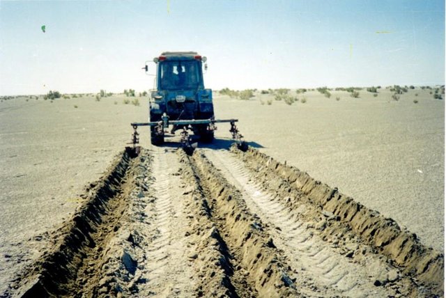
លក្ខណៈពិសេសនៃបច្ចេកទេស (ទាក់ទងនឺងគំនូរបច្ចេកទេស):
Ameliorative plantings
Technical knowledge required for field staff / advisors: low
Technical knowledge required for land users: low
Main technical functions: reduction in wind speed
Aligned: -against wind
Vegetative material: T : trees / shrubs, G : grass
Number of plants per (ha): 3000
Vertical interval between rows / strips / blocks (m): 2
Spacing between rows / strips / blocks (m): 2
Vertical interval within rows / strips / blocks (m): 1,5
Width within rows / strips / blocks (m): 0,2
Trees/ shrubs species: saxaul seedling
Grass species: prostrate summer cypress, winterfat, corn
Dam/ pan/ pond
Vertical interval between structures (m): 2
Spacing between structures (m): 2
Height of bunds/banks/others (m): 0,05
Width of bunds/banks/others (m): 0,5
Length of bunds/banks/others (m): 100
Construction material (other): Reed fascines
4.2 ព័ត៌មានទូទៅដែលពាក់ព័ន្ធនឹងការគណនាធាតុចូល និងថ្លៃដើម
កំណត់រូបិយប័ណ្ណសម្រាប់ថ្លៃដើម:
- ដុល្លារ
កំណត់ថ្លៃឈ្នួលជាមធ្យមនៃការជួលកម្លាំងពលកម្មក្នុងមួយថ្ងៃ:
5.00
4.3 សកម្មភាពបង្កើត
| សកម្មភាព | រយៈពេល (រដូវកាល) | |
|---|---|---|
| 1. | Stacking of fascines | summer |
| 2. | Slips' planting | autumn, spring |
| 3. | Laying fascines | summer |
| 4. | Slips' planting | spring, autumn |
4.4 ថ្លៃដើម និងធាតុចូលដែលត្រូវការសម្រាប់ការបង្កើតបច្ចេកទេស
| បញ្ជាក់ពីធាតុចូល | ឯកតា | បរិមាណ | ថ្លៃដើមក្នុងមួយឯកតា | ថ្លៃធាតុចូលសរុប | % នៃថ្លៃដើមដែលចំណាយដោយអ្នកប្រើប្រាស់ដី | |
|---|---|---|---|---|---|---|
| កម្លាំងពលកម្ម | Labour | persons/day/ha | 3,0 | 5,0 | 15,0 | 100,0 |
| សម្ភារៈ | Machine use | ha | 1,0 | 20,0 | 20,0 | 100,0 |
| សម្ភារៈ | Tools | ha | 1,0 | 10,0 | 10,0 | 100,0 |
| សម្ភារៈដាំដុះ | Seedlings | ha | 1,0 | 165,0 | 165,0 | 100,0 |
| សម្ភារៈសាងសង់ | Other | ha | 1,0 | 10,0 | 10,0 | 100,0 |
| ថ្លៃដើមសរុបក្នុងការបង្កើតបច្ចេកទេស | 220,0 | |||||
| ថ្លៃដើមសរុបក្នុងការបង្កើតបច្ចេកទេសគិតជាដុល្លារ | 220,0 | |||||
មតិយោបល់:
Duration of establishment phase: 24 month(s)
4.5 សកម្មភាពថែទាំ
| សកម្មភាព | ពេលវេលា/ ភាពញឹកញាប់ | |
|---|---|---|
| 1. | Additional planting | spring /1 |
| 2. | Supplementary slips' planting | spring, autumn/1 |
| 3. | Supplementary fascines' setting | spring, autumn/1 |
4.6 កំណត់ថ្លៃដើមសម្រាប់ការថែទាំ/ សកម្មភាពរបស់បច្ចេកទេស (ក្នុងរយៈពេលមួយឆ្នាំ)
មតិយោបល់:
Reed fascines against deflation 100 m in length, 0,5 m in breadth 50 pieces per ha
Saxaul’s seedling every 2 m lines, distance between slips-1.5 m, 3300 pieces per ha
4.7 កត្តាសំខាន់បំផុតដែលមានឥទ្ធិពលដល់ការចំណាយ
ពណ៌នាពីកត្តាប៉ះពាល់ចម្បងៗទៅលើថ្លៃដើម:
Manufacturing of reed fascines, purchase and planting saxaul's seedlinfs
5. លក្ខណៈបរិស្ថានធម្មជាតិ និងមនុស្ស
5.1 អាកាសធាតុ
បរិមាណទឹកភ្លៀងប្រចាំឆ្នាំ
- < 250 មម
- 251-500 មម
- 501-750 មម
- 751-1,000 មម
- 1,001-1,500 មម
- 1,501-2,000 មម
- 2,001-3,000 មម
- 3,001-4,000 មម
- > 4,000 មម
កំណត់បរិមាណទឹកភ្លៀង (បើដឹង) ជា មីលីម៉ែត្រ:
124,00
តំបន់កសិអាកាសធាតុ
- ស្ងួត
Deserted
5.2 សណ្ឋានដី
ជម្រាលជាមធ្យម:
- រាបស្មើ (0-2%)
- ជម្រាលតិចតួច (3-5%)
- មធ្យម (6-10%)
- ជម្រាលខ្ពស់បន្តិច (11-15%)
- ទីទួល (16-30%)
- ទីទួលចោត (31-60%)
- ទីទួលចោតខ្លាំង (>60%)
ទម្រង់ដី:
- ខ្ពង់រាប
- កំពូលភ្នំ
- ជម្រាលភ្នំ
- ជម្រាលទួល
- ជម្រាលជើងភ្នំ
- បាតជ្រលងភ្នំ
តំបន់តាមរយៈកម្ពស់ :
- 0-100 ម
- 101-500 ម
- 501-1,000 ម
- 1,001-1,500 ម
- 1,501-2,000 ម
- 2,001-2,500 ម
- 2,501-3,000 ម
- 3,001-4,000 ម
- > 4,000 ម
មតិយោបល់ និងបញ្ចាក់បន្ថែមអំពីសណ្ឋានដី :
Altitudinal zone: 58-53 m abs. of hight
Landforms: Poorly wavy inclined plan
Slopes on average: Weakly wavy
5.3 ដី
ជម្រៅដីជាមធ្យម:
- រាក់ខ្លាំង (0-20 សម)
- រាក់ (21-50 សម)
- មធ្យម (51-80 សម)
- ជ្រៅ (81-120 សម)
- ជ្រៅខ្លាំង (> 120 សម)
វាយនភាពដី (ស្រទាប់លើ):
- គ្រើម/ មានពន្លឺ (ខ្សាច់)
- មធ្យម (ល្បាយ, ល្បាប់)
សារធាតុសរីរាង្គនៅស្រទាប់ដីខាងលើ:
- ទាប (<1%)
បើអាចសូមភ្ជាប់ការពណ៌នាពីដីឱ្យបានច្បាស់ ឬព័ត៌មានដែលអាចទទួលបាន ឧ. ប្រភេទដី, pH ដី/ ជាតិអាស៊ីត, សមត្ថភាពផ្លាស់ប្តូរកាចុង, វត្តមាននីត្រូសែន, ភាពប្រៃ ។ល។:
Soil depth on average: Depth of humus under 5sm
Soil fertility is very low 0,191 of humus
Topsoil organic matter: 0,13-0,26%
Soil drainage / infiltration is good ins sandy and loamy soils and medium in clay
Soil water storage capacity is very low - low
5.6 លក្ខណៈនៃអ្នកប្រើប្រាស់ដីដែលអនុវត្តបច្ចេកទេស
ទីផ្សារនៃប្រព័ន្ធផលិតកម្ម:
- ពាក់កណ្តាលពាណិជ្ជកម្ម (ផ្គត់ផ្គង់ខ្លួនឯង/ ពាណិជ្ជកម្ម)
ចំណូលក្រៅកសិកម្ម:
- តិចជាង 10% នៃចំណូល
កម្រិតជីវភាព:
- មិនល្អខ្លាំង
- មិនល្អ
កម្រិតប្រើប្រាស់គ្រឿងយន្ត:
- ប្រើកម្លាំងពលកម្ម
សូមបញ្ជាក់ពីលក្ខណៈពាក់ព័ន្ធផ្សេងទៀតអំពីអ្នកប្រើប្រាស់ដី:
Annual population growth: negative
20% of the land users are average wealthy and own 60% of the land.
20% of the land users are poor and own 20% of the land.
60% of the land users are poor and own 20% of the land.
Off-farm income specification: With falling a level of Aral sea and degradation of the natural invironment in dicline there came all branches of agriculture and fishing industry
Level of mechanization: Fascines and planting of bushes are manually spread
Market orientation of production system: Rise of pastures' fodder capacity
5.7 ទំហំផ្ទៃដីជាមធ្យមនៃដីប្រើប្រាស់ដោយអ្នកប្រើប្រាស់ដី ក្នុងការអនុវត្តបច្ចេកទេស
- < 0.5 ហិកតា
- 0.5-1 ហិកតា
- 1-2 ហិកតា
- 2-5 ហិកតា
- 5-15 ហិកតា
- 15-50 ហិកតា
- 50-100 ហិកតា
- 100-500 ហិកតា
- 500-1,000 ហិកតា
- 1,000-10,000 ហិកតា
- > 10,000 ហិកតា
5.8 ភាពជាម្ចាស់ដី កម្មសិទ្ធប្រើប្រាស់ដី និងកម្មសិទ្ធប្រើប្រាស់ទឹក
ភាពជាម្ចាស់ដី:
- រដ្ឋ
កម្មសិទ្ធិប្រើប្រាស់ដី:
- ជាក្រុម (មានដែនកំណត់)
- ឯកជន
6. ផលប៉ះពាល់ និងការសន្និដ្ឋាន
6.1 ផលប៉ះពាល់ក្នុងបរិវេណអនុវត្តបច្ចេកទេសដែលកើតមាន
ផលប៉ះពាល់លើសេដ្ឋកិច្ចសង្គម
ផលិតផល
ផលិតកម្មដំណាំ
មតិយោបល់/ ការបញ្ជាក់:
The projective covering increases
ចំណូល និងថ្លៃដើម
ចំណូលក្នុងកសិដ្ឋាន
មតិយោបល់/ ការបញ្ជាក់:
Increase in effeciency of livestock
បន្ទុកការងារ
មតិយោបល់/ ការបញ្ជាក់:
Manual labour
ផលប៉ះពាល់ទៅលើសេដ្ឋកិច្ចសង្គមផ្សេងៗ
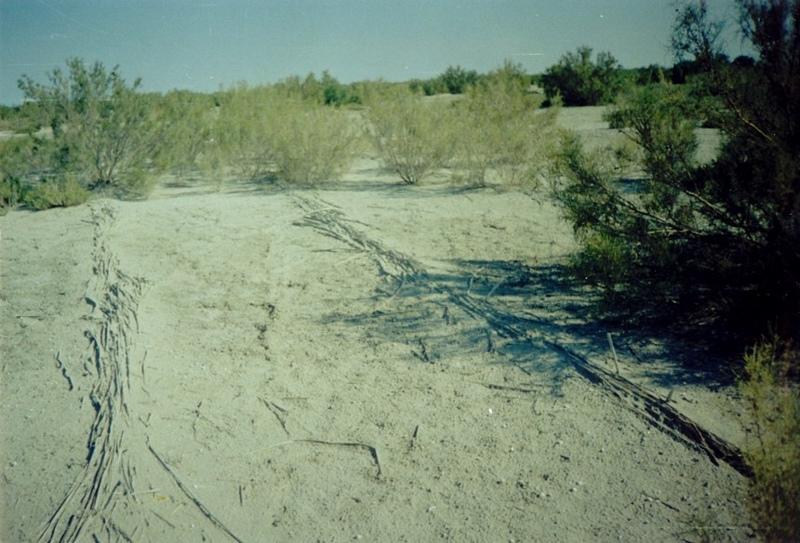
Fastening of surface
មតិយោបល់/ ការបញ្ជាក់:
Stoppage of blowing
ផលប៉ះពាល់ទៅលើវប្បធម៌សង្គម
ស្ថាប័នសហគមន៍
មតិយោបល់/ ការបញ្ជាក់:
Increase of farmer's living level
ផលប៉ះពាល់ទៅលើអេកូឡូស៊ី
ដី
គម្របដី
មតិយោបល់/ ការបញ្ជាក់:
Surface stabilization
ការបាត់បង់ដី
មតិយោបល់/ ការបញ្ជាក់:
Blowing stops
ការកាត់បន្ថយហានិភ័យនៃគ្រោះមហន្តរាយ និងគ្រោះអាកាសធាតុ
ល្បឿនខ្យល់
មតិយោបល់/ ការបញ្ជាក់:
Times are occupied
ផលប៉ះពាល់ទៅលើអេកូឡូស៊ីផ្សេងៗ
biodiversity
6.2 ផលប៉ះពាល់ក្រៅបរិវេណអនុវត្តបច្ចេកទេសដែលកើតមាន
ខ្យល់នាំយកនូវធូរលី
មតិយោបល់/ ការបញ្ជាក់:
Erosion of surface of the ground are stopping
6.4 ការវិភាគថ្លៃដើម និងអត្ថប្រយោជន៍
តើផលចំណេញ និងថ្លៃដើមត្រូវបានប្រៀបធៀបគ្នាយ៉ាងដូចម្តេច (ទស្សនៈរបស់អ្នកប្រើប្រាស់ដី)?
រយៈពេលវែង:
វិជ្ជមានតិចតួច
តើផលចំណេញ និងការថែទាំ/ ជួសជុលត្រូវបានប្រៀបធៀបគ្នាយ៉ាងដូចម្តេច (ទស្សនៈរបស់អ្នកប្រើប្រាស់ដី)?
រយៈពេលវែង:
វិជ្ជមានតិចតួច
6.5 ការទទួលយកបច្ចេកទេស
- 11-50%
បើអាច សូមបញ្ជាក់ពីបរិមាណ (ចំនួនគ្រួសារ និង/ ឬតំបន់គ្របដណ្តប់):
15 households covering 20 percent of stated area
ក្នុងចំណោមគ្រួសារទាំងអស់ដែលបានអនុវត្តបច្ចេកទេស តើមានប៉ុន្មានគ្រួសារដែលចង់ធ្វើដោយខ្លួនឯង ដោយមិនទទួលបានសម្ភារៈលើកទឹកចិត្ត/ប្រាក់ឧបត្ថម្ភ?:
- 91-100%
មតិយោបល់:
15 land user families have adopted the Technology without any external material support
Comments on spontaneous adoption: survey results
There is a moderate trend towards spontaneous adoption of the Technology
Comments on adoption trend: The increase of deflated and eroded areas compels farmers to apply SWC
6.7 ភាពខ្លាំង/ គុណសម្បត្តិ/ ឱកាសនៃបច្ចេកទេស
| ភាពខ្លាំង/ គុណសម្បត្តិ/ ឱកាសនៅកន្លែងរបស់អ្នកប្រើប្រាស់ដី |
|---|
|
Decrease in the areas of wind and water erosion How can they be sustained / enhanced? For a long time enough depending on life cycle of wood-bushes vegetation |
|
Improvement of microclimatic conditions of settlements How can they be sustained / enhanced? During all time of existence of the green zone created with the help of SWC |
| ភាពខ្លាំង/ គុណសម្បត្តិ/ ឱកាស ទស្សនៈរបស់បុគ្គលសំខាន់ៗ |
|---|
|
Stabilization of mobile sand How can they be sustained / enhanced? At rational use of technology the created ecosystem can be supported for some life cycles with help of the main wood breed |
| Elimination of drifts of settlements by sand |
| Returning the grounds in rotation of the pasture |
| Creation of additional workplaces |
6.8 ភាពខ្សោយ/ គុណវិបត្តិ/ ហានិភ័យនៃបច្ចេកទេស និងវិធីសាស្ត្រដោះស្រាយ
| ភាពខ្សោយ/ គុណវិបត្តិ/ ហានិភ័យ ទស្សនៈរបស់អ្នកប្រើប្រាស់ដី | តើបច្ចេកទេសទាំងនោះបានដោះស្រាយបញ្ហាដូចម្តេច? |
|---|---|
| Shortage of seedlings for the big areas | Creation of artificial nurseries |
| ភាពខ្សោយ/ គុណវិបត្តិ/ ហានិភ័យ ទស្សនៈរបស់អ្នកចងក្រងឬបុគ្គលសំខាន់ៗ | តើបច្ចេកទេសទាំងនោះបានដោះស្រាយបញ្ហាដូចម្តេច? |
|---|---|
| Almost hundred percentage use of manual skills | Development of new machines and mechanisms |
| Probably low survival of seedlings and absence of shoots because the weather conditions are not good enough | The organization of post planting watering |
7. ឯកសារយោង និងវេបសាយ
7.1 វិធីសាស្ត្រ/ ប្រភពនៃព័ត៌មាន
7.2 ឯកសារយោងដែលបានចេញផ្សាយ
ចំណងជើង អ្នកនិពន្ធ ឆ្នាំ ISBN:
"To develop scientific bases of forest amelioration of the grounds of a naked bottom of Aral sea, classification of types of growth conditions" Kaverin V.S.. 2000y.
មានប្រភពមកពីណា? ថ្លៃដើមប៉ុន្មាន?
SPC for forest facility58 Kirov str. Shuchinsk cityAkmola regionThe Republic of Kazakhstan
ការតភ្ជាប់ និងម៉ូឌុល
ពង្រីកមើលទាំងអស់ បង្រួមទាំងអស់ការតភ្ជាប់
The approach of groove fastening sandy loam and … [ប្រទេសកាហ្សាក់ស្ថាន]
The approach of groove fastening sandy-loam and sandy soils of the Aral sea's drained bottom
- អ្នកចងក្រង៖ Vladimir Kaverin
ម៉ូឌុល
គ្មានម៉ូឌុល