creation of meliorative plantings for struggle with erosion [คาซัคสถาน]
- ผู้สร้างสรรค์:
- การอัพเดท:
- ผู้รวบรวม: Vladimir Kaverin
- ผู้เรียบเรียง: –
- ผู้ตรวจสอบ: David Streiff, Alexandra Gavilano
no
technologies_1482 - คาซัคสถาน
ดูส่วนย่อย
ขยายทั้งหมด ย่อทั้งหมด1. ข้อมูลทั่วไป
1.2 รายละเอียดที่ติดต่อได้ของผู้รวบรวมและองค์กรที่เกี่ยวข้องในการประเมินและการจัดเตรียมทำเอกสารของเทคโนโลยี
ผู้เชี่ยวชาญ SLM:
Salimov Abdul-Bari
SPC for forest facility
คาซัคสถาน
ชื่อขององค์กรซึ่งอำนวยความสะดวกในการทำเอกสารหรือการประเมินเทคโนโลยี (ถ้าเกี่ยวข้อง)
SPC of Forest Facility (SPC of Forest Facility) - คาซัคสถาน1.3 เงื่อนไขการใช้ข้อมูลที่ได้บันทึกผ่านทาง WOCAT
ผู้รวบรวมและวิทยากรหลักยอมรับเงื่อนไขเกี่ยวกับการใช้ข้อมูลที่ถูกบันทึกผ่านทาง WOCAT:
ใช่
1.5 Reference to Questionnaire(s) on SLM Approaches (documented using WOCAT)
The approach of groove fastening sandy loam and … [คาซัคสถาน]
The approach of groove fastening sandy-loam and sandy soils of the Aral sea's drained bottom
- ผู้รวบรวม: Vladimir Kaverin
2. การอธิบายลักษณะของเทคโนโลยี SLM
2.1 การอธิบายแบบสั้น ๆ ของเทคโนโลยี
คำจำกัดความของเทคโนโลยี:
Technology of creation of meliorative plantings for struggle against wind and water erosion
2.2 การอธิบายแบบละเอียดของเทคโนโลยี
คำอธิบาย:
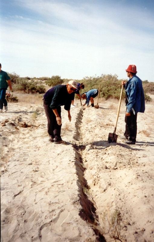
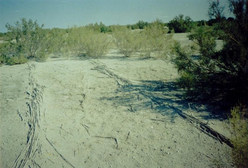
In Syrdarya river’s delta on alluvial drought sandy and loam sand soils processes of wind and water erosion become more active with a view of protection of the soils it is applied covering fascine made from a local cane or reed. Fascines thickness 12-15 cm settle down on a surface by lines in a 2-3 m. On distance of 20 centimeters it is carried out planting of a saxaul seedlings
-Planting of the saplings was done in holes and uninterrupted furrows, which were formed by hands.
-Depth of holes and furrows is 20-25 cm.
-Distance between holes was 1.5-2 m.
-Furrows were perpendicular to the prevailing winds (west-east) and placing mould in several optio0ns: 1- moulds on both sides; 2- the same from the southern side of a furrow; 3- the same from the northern side. Furrows alternated with holes rows.
-Length of rows variants in repetition was 100 m.
-Saplings were filled up by hands in rows in 1-2 meters, distance between rows was 2-2.5 meters.
Prevention of water and wind erosion on sandy and loamy sand soils of the Syrdarya delta.
Many farmers use the given technology for prevention of wind and water erosion on the lands.
The technology is applied on the area of 1.5 sq.km. Expenses per 1 ha make 99.2 $ USA or 14880 tenge.
Irrevocable water consumption in agricultural land use in the Syrdarya delta, development of the areas of irrigation, livestock grazing led to the contradiction between the agricultural industry and the ecological state of the region. It caused more intense processes of desertification, among them are soil salification and increase in the groundwater mineralization: degradation of vegetation cover; erosion and soil deflation; wind-blowing of the salts from dried bed of the Aral Sea; sand advance on the arable land, etc. At present about of 60% of irrigated areas within the Syrdarya delta are strongly salificated.
2.3 รูปภาพของเทคโนโลยี
อัลบั้มสื่อบันทึก
2.5 ประเทศภูมิภาค หรือสถานที่ตั้งที่เทคโนโลยีได้นำไปใช้และได้รับการครอบคลุมโดยการประเมินนี้
ประเทศ:
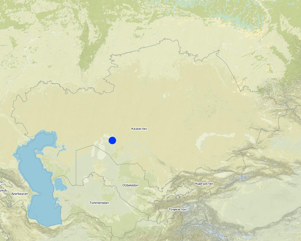
คาซัคสถาน
ภูมิภาค/รัฐ/จังหวัด:
Kyzylorda oblast
ข้อมูลจำเพาะเพิ่มเติมของสถานที่ตั้ง :
Kazalinsk
ระบุการกระจายตัวของเทคโนโลยี:
- กระจายไปอย่างสม่ำเสมอในพื้นที่
If the Technology is evenly spread over an area, specify area covered (in km2):
3.5
If precise area is not known, indicate approximate area covered:
- 1-10 ตร.กม.
แสดงความคิดเห็น:
Total area covered by the SLM Technology is 3.5 km2.
Loamy sand and sandy alluvial desertification soils of delta of the river Syrdarya are subject to process of wind erosion Deflation-accumulative prosses create threat for settlement
Map
×2.6 วันที่การดำเนินการ
ถ้าไม่รู้ปีที่แน่นอน ให้ระบุวันที่โดยประมาณ:
- น้อยกว่า 10 ปี (ไม่นานนี้)
2.7 คำแนะนำของเทคโนโลยี
ให้ระบุว่าเทคโนโลยีถูกแนะนำเข้ามาอย่างไร:
- ในช่วงการทดลองหรือการทำวิจัย
ความคิดเห็น (ประเภทของโครงการ เป็นต้น) :
From Kazakh Research Institute of forest management at 1989-2002
3. การจัดประเภทของเทคโนโลยี SLM
3.1 วัตถุประสงค์หลักของเทคโนโลยี
- ลด ป้องกัน ฟื้นฟู การเสื่อมโทรมของที่ดิน
- ลดความเสี่ยงของภัยพิบัติ
3.2 ประเภทของการใช้ที่ดินในปัจจุบันที่ได้นำเทคโนโลยีไปใช้
Land use mixed within the same land unit:
ใช่
Specify mixed land use (crops/ grazing/ trees):
- การปลูกพืชร่วมกับปศุสัตว์และการทำป่าไม้ (Agro-silvopastoralism)

พื้นที่ปลูกพืช
- การปลูกพืชล้มลุกอายุปีเดียว
- การปลูกไม้ยืนต้น ไม้พุ่ม
Annual cropping - Specify crops:
- cereals - maize
- cereals - rice (upland)
Tree and shrub cropping - Specify crops:
- fodder trees (Calliandra, Leucaena leucocephala, Prosopis, etc.)
- Saxaul (cf. Haloxylon ammodendron)
จำนวนของฤดูเพาะปลูกต่อปี:
- 2
ระบุ:
Longest growing period in days: 208; Longest growing period from month to month: Apr - Oct

ทุ่งหญ้าเลี้ยงสัตว์
Extensive grazing:
- กึ่งโนแมนดิซึ่มหรือแพสโตแรลลิซึ่ม (Semi-nomadism/pastoralism)

ป่า/พื้นที่ทำไม้
ผลิตภัณฑ์และบริการ:
- ไม้ที่นำมาทำเป็นเชื้อเพลิง
แสดงความคิดเห็น:
Trees/ shrubs species: saxaul seedling
Grass species: prostrate summer cypress, winterfat, corn
Major land use problems (compiler’s opinion): Loss of biological variety, degrodation of lands for agriculturing
Major land use problems (land users’ perception): Approach of sand to settlements and agricultural grounds
Grazingland comments: With a transitional economy and absence of market relations it is prevail a fine farms with a small amount of cattle on a farmstead
Type of grazing system comments: With a transitional economy and absence of market relations it is prevail a fine farms with a small amount of cattle on a farmstead
Constraints of mines and extractive industries: old system of landed property
Livestock in deltoid meadows
3.4 การใช้น้ำ
การใช้น้ำของที่ดินที่มีการใช้เทคโนโลยีอยู่:
- จากน้ำฝน
3.5 กลุ่ม SLM ที่ตรงกับเทคโนโลยีนี้
- แนวกันลมหรือแนวต้านลม
- การปรับปรุงดิน / พืชคลุมดิน
3.6 มาตรการ SLM ที่ประกอบกันเป็นเทคโนโลยี

มาตรการอนุรักษ์ด้วยวิธีพืช
- V1: ต้นไม้และพุ่มไม้คลุมดิน

มาตรการอนุรักษ์ด้วยโครงสร้าง
- S3: Graded ditches, channels, waterways
แสดงความคิดเห็น:
Secondary measures: structural measures
Type of vegetative measures: aligned: -against wind
3.7 รูปแบบหลักของการเสื่อมโทรมของที่ดินที่ได้รับการแก้ไขโดยเทคโนโลยี

การกัดกร่อนของดินโดยน้ำ
- Wt (Loss of topsoil): การสูญเสียดินชั้นบนหรือการกัดกร่อนที่ผิวดิน

การกัดกร่อนของดินโดยลม
- Et (Loss of topsoil): การสูญเสียดินชั้นบน
แสดงความคิดเห็น:
Secondary types of degradation addressed: Wt: loss of topsoil / surface erosion
Main causes of degradation: other human induced causes (specify) (agricultural causes - Excessive water-fence on an irrigation from the rivers Syrdarya and Amurdarya.)
Secondary causes of degradation: deforestation / removal of natural vegetation (incl. forest fires) (Destraction saxaul fuel.), other natural causes (avalanches, volcanic eruptions, mud flows, highly susceptible natural resources, extreme topography, etc.) specify (High wind activity in region (prevalence of winds with a speed up to 5 min/sec).)
3.8 การป้องกัน การลดลง หรือการฟื้นฟูความเสื่อมโทรมของที่ดิน
ระบุเป้าหมายของเทคโนโลยีกับความเสื่อมโทรมของที่ดิน:
- ป้องกันความเสื่อมโทรมของที่ดิน
- ฟื้นฟูบำบัดที่ดินที่เสื่อมโทรมลงอย่างมาก
4. ข้อมูลจำเพาะด้านเทคนิค กิจกรรมการนำไปปฏิบัติใช้ ปัจจัยนำเข้า และค่าใช้จ่าย
4.1 แบบแปลนทางเทคนิคของเทคโนโลยี
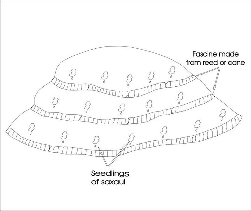
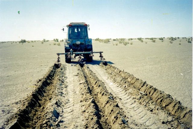
ข้อมูลจำเพาะด้านเทคนิค (แบบแปลนทางเทคนิคของเทคโนโลยี):
Ameliorative plantings
Technical knowledge required for field staff / advisors: low
Technical knowledge required for land users: low
Main technical functions: reduction in wind speed
Aligned: -against wind
Vegetative material: T : trees / shrubs, G : grass
Number of plants per (ha): 3000
Vertical interval between rows / strips / blocks (m): 2
Spacing between rows / strips / blocks (m): 2
Vertical interval within rows / strips / blocks (m): 1,5
Width within rows / strips / blocks (m): 0,2
Trees/ shrubs species: saxaul seedling
Grass species: prostrate summer cypress, winterfat, corn
Dam/ pan/ pond
Vertical interval between structures (m): 2
Spacing between structures (m): 2
Height of bunds/banks/others (m): 0,05
Width of bunds/banks/others (m): 0,5
Length of bunds/banks/others (m): 100
Construction material (other): Reed fascines
4.2 ข้อมูลทั่วไปเกี่ยวกับการคำนวณปัจจัยนำเข้าและค่าใช้จ่าย
ระบุสกุลเงินที่ใช้คำนวณค่าใช้จ่าย:
- USD
ระบุค่าเฉลี่ยของค่าจ้างในการจ้างแรงงานต่อวัน:
5.00
4.3 กิจกรรมเพื่อการจัดตั้ง
| กิจกรรม | Timing (season) | |
|---|---|---|
| 1. | Stacking of fascines | summer |
| 2. | Slips' planting | autumn, spring |
| 3. | Laying fascines | summer |
| 4. | Slips' planting | spring, autumn |
4.4 ค่าใช้จ่ายของปัจจัยนำเข้าที่จำเป็นสำหรับการจัดตั้ง
| ปัจจัยนำเข้า | หน่วย | ปริมาณ | ค่าใช้จ่ายต่อหน่วย | ค่าใช้จ่ายทั้งหมดต่อปัจจัยนำเข้า | %ของค่าใช้จ่ายที่ก่อให้เกิดขึ้นโดยผู้ใช้ที่ดิน | |
|---|---|---|---|---|---|---|
| แรงงาน | Labour | persons/day/ha | 3.0 | 5.0 | 15.0 | 100.0 |
| อุปกรณ์ | Machine use | ha | 1.0 | 20.0 | 20.0 | 100.0 |
| อุปกรณ์ | Tools | ha | 1.0 | 10.0 | 10.0 | 100.0 |
| วัสดุด้านพืช | Seedlings | ha | 1.0 | 165.0 | 165.0 | 100.0 |
| วัสดุสำหรับก่อสร้าง | Other | ha | 1.0 | 10.0 | 10.0 | 100.0 |
| ค่าใช้จ่ายทั้งหมดของการจัดตั้งเทคโนโลยี | 220.0 | |||||
| Total costs for establishment of the Technology in USD | 220.0 | |||||
แสดงความคิดเห็น:
Duration of establishment phase: 24 month(s)
4.5 การบำรุงรักษาสภาพหรือกิจกรรมที่เกิดขึ้นเป็นประจำ
| กิจกรรม | ช่วงระยะเวลา/ความถี่ | |
|---|---|---|
| 1. | Additional planting | spring /1 |
| 2. | Supplementary slips' planting | spring, autumn/1 |
| 3. | Supplementary fascines' setting | spring, autumn/1 |
4.6 ค่าใช้จ่ายของปัจจัยนำเข้าและกิจกรรมที่เกิดขึ้นเป็นประจำที่ต้องการการบำรุงรักษา (ต่อปี)
แสดงความคิดเห็น:
Reed fascines against deflation 100 m in length, 0,5 m in breadth 50 pieces per ha
Saxaul’s seedling every 2 m lines, distance between slips-1.5 m, 3300 pieces per ha
4.7 ปัจจัยสำคัญที่สุดที่มีผลกระทบต่อค่าใช้จ่าย
ปัจจัยสำคัญที่สุดที่มีผลกระทบต่อค่าใช้จ่ายต่างๆ:
Manufacturing of reed fascines, purchase and planting saxaul's seedlinfs
5. สิ่งแวดล้อมทางธรรมชาติและของมนุษย์
5.1 ภูมิอากาศ
ฝนประจำปี
- < 250 ม.ม.
- 251-500 ม.ม.
- 501-750 ม.ม.
- 751-1,000 ม.ม.
- 1,001-1,500 ม.ม.
- 1,501-2,000 ม.ม.
- 2,001-3,000 ม.ม.
- 3,001-4,000 ม.ม.
- > 4,000 ม.ม.
ระบุปริมาณน้ำฝนเฉลี่ยรายปี (ถ้ารู้) :หน่วย ม.ม.
124.00
เขตภูมิอากาศเกษตร
- แห้งแล้ง
Deserted
5.2 สภาพภูมิประเทศ
ค่าเฉลี่ยความลาดชัน:
- ราบเรียบ (0-2%)
- ลาดที่ไม่ชัน (3-5%)
- ปานกลาง (6-10%)
- เป็นลูกคลื่น (11-15%)
- เป็นเนิน (16-30%)
- ชัน (31-60%)
- ชันมาก (>60%)
ธรณีสัณฐาน:
- ที่ราบสูง/ที่ราบ
- สันเขา
- ไหล่เขา
- ไหล่เนินเขา
- ตีนเนิน
- หุบเขา
ระดับความสูง:
- 0-100 เมตร
- 101-500 เมตร
- 501-1,000 เมตร
- 1,001-1,500 เมตร
- 1,501-2,000 เมตร
- 2,001-2,500 เมตร
- 2,501-3,000 เมตร
- 3,001-4,000 เมตร
- > 4,000 เมตร
ความคิดเห็นและข้อมูลจำเพาะเพิ่มเติมเรื่องสภาพภูมิประเทศ:
Altitudinal zone: 58-53 m abs. of hight
Landforms: Poorly wavy inclined plan
Slopes on average: Weakly wavy
5.3 ดิน
ค่าเฉลี่ยความลึกของดิน:
- ตื้นมาก (0-20 ซ.ม.)
- ตื้น (21-50 ซ.ม.)
- ลึกปานกลาง (51-80 ซ.ม.)
- ลึก (81-120 ซ.ม.)
- ลึกมาก (>120 ซ.ม.)
เนื้อดิน (ดินชั้นบน):
- หยาบ/เบา (ดินทราย)
- ปานกลาง (ดินร่วน ทรายแป้ง)
อินทรียวัตถุในดิน:
- ต่ำ (<1%)
(ถ้ามี) ให้แนบคำอธิบายเรื่องดินแบบเต็มหรือระบุข้อมูลที่มีอยู่ เช่น ชนิดของดิน ค่า pH ของดินหรือความเป็นกรดของดิน ความสามารถในการแลกเปลี่ยนประจุบวก ไนโตรเจน ความเค็ม เป็นต้น:
Soil depth on average: Depth of humus under 5sm
Soil fertility is very low 0,191 of humus
Topsoil organic matter: 0,13-0,26%
Soil drainage / infiltration is good ins sandy and loamy soils and medium in clay
Soil water storage capacity is very low - low
5.6 ลักษณะของผู้ใช้ที่ดินที่นำเทคโนโลยีไปปฏิบัติใช้
แนวทางการตลาดของระบบการผลิต:
- mixed (subsistence/ commercial)
รายได้ที่มาจากนอกฟาร์ม:
- < 10% ของรายได้ทั้งหมด
ระดับของความมั่งคั่งโดยเปรียบเทียบ:
- ยากจนมาก
- จน
ระดับของการใช้เครื่องจักรกล:
- งานที่ใช้แรงกาย
ระบุลักษณะอื่นๆที่เกี่ยวข้องของผู้ใช้ที่ดิน:
Annual population growth: negative
20% of the land users are average wealthy and own 60% of the land.
20% of the land users are poor and own 20% of the land.
60% of the land users are poor and own 20% of the land.
Off-farm income specification: With falling a level of Aral sea and degradation of the natural invironment in dicline there came all branches of agriculture and fishing industry
Level of mechanization: Fascines and planting of bushes are manually spread
Market orientation of production system: Rise of pastures' fodder capacity
5.7 Average area of land used by land users applying the Technology
- < 0.5 เฮกตาร์
- 0.5-1 เฮกตาร์
- 1-2 เฮกตาร์
- 2-5 เฮกตาร์
- 5-15 เฮกตาร์
- 15-50 เฮกตาร์
- 50-100 เฮกตาร์
- 100-500 เฮกตาร์
- 500-1,000 เฮกตาร์
- 1,000-10,000 เฮกตาร์
- >10,000 เฮกตาร์
5.8 กรรมสิทธิ์ในที่ดิน สิทธิในการใช้ที่ดินและสิทธิในการใช้น้ำ
กรรมสิทธิ์ในที่ดิน:
- รัฐ
สิทธิในการใช้ที่ดิน:
- เกี่ยวกับชุมชน (ถูกจัดระเบียบ)
- รายบุคคล
6. ผลกระทบและสรุปคำบอกกล่าว
6.1 ผลกระทบในพื้นที่ดำเนินการ (On-site) จากการใช้เทคโนโลยี
ผลกระทบทางด้านเศรษฐกิจและสังคม
การผลิต
การผลิตพืชผล
แสดงความคิดเห็น/ระบุ:
The projective covering increases
รายได้และค่าใช้จ่าย
รายได้จากฟาร์ม
แสดงความคิดเห็น/ระบุ:
Increase in effeciency of livestock
ภาระงาน
แสดงความคิดเห็น/ระบุ:
Manual labour
ผลกระทบทางด้านเศรษฐกิจและสังคมอื่น ๆ
Fastening of surface
แสดงความคิดเห็น/ระบุ:
Stoppage of blowing
ผลกระทบด้านสังคมวัฒนธรรมอื่น ๆ
สถาบันของชุมชน
แสดงความคิดเห็น/ระบุ:
Increase of farmer's living level
ผลกระทบด้านนิเวศวิทยา
ดิน
สิ่งปกคลุมดิน
แสดงความคิดเห็น/ระบุ:
Surface stabilization
การสูญเสียดิน
แสดงความคิดเห็น/ระบุ:
Blowing stops
ลดความเสี่ยงของภัยพิบัติ
ความเร็วของลม
แสดงความคิดเห็น/ระบุ:
Times are occupied
ผลกระทบด้านนิเวศวิทยาอื่น ๆ
biodiversity
6.2 ผลกระทบนอกพื้นที่ดำเนินการ (Off-site) จากการใช้เทคโนโลยี
ตะกอนที่ถูกพัดพามาโดยลม
แสดงความคิดเห็น/ระบุ:
Erosion of surface of the ground are stopping
6.4 การวิเคราะห์ค่าใช้จ่ายและผลประโยชน์ที่ได้รับ
ผลประโยชน์ที่ได้รับเปรียบเทียบกับค่าใช้จ่ายในการจัดตั้งเป็นอย่างไร (จากมุมมองของผู้ใช้ที่ดิน)
ผลตอบแทนระยะยาว:
ด้านบวกเล็กน้อย
ผลประโยชน์ที่ได้รับเปรียบเทียบกับค่าใช้จ่ายในการบำรุงรักษาหรือต้นทุนที่เกิดขึ้นซ้ำอีก เป็นอย่างไร (จากมุมมองของผู้ใช้ที่ดิน)
ผลตอบแทนระยะยาว:
ด้านบวกเล็กน้อย
6.5 การปรับตัวของเทคโนโลยี
- 11-50%
ถ้ามีข้อมูลให้บอกปริมาณด้วย (จำนวนของครัวเรือนหรือครอบคลุมพื้นที่):
15 households covering 20 percent of stated area
Of all those who have adopted the Technology, how many did so spontaneously, i.e. without receiving any material incentives/ payments?
- 91-100%
แสดงความคิดเห็น:
15 land user families have adopted the Technology without any external material support
Comments on spontaneous adoption: survey results
There is a moderate trend towards spontaneous adoption of the Technology
Comments on adoption trend: The increase of deflated and eroded areas compels farmers to apply SWC
6.7 จุดแข็ง / ข้อได้เปรียบ / โอกาสของเทคโนโลยี
| จุดแข็ง / ข้อได้เปรียบ / โอกาสในทัศนคติของผู้ใช้ที่ดิน |
|---|
|
Decrease in the areas of wind and water erosion How can they be sustained / enhanced? For a long time enough depending on life cycle of wood-bushes vegetation |
|
Improvement of microclimatic conditions of settlements How can they be sustained / enhanced? During all time of existence of the green zone created with the help of SWC |
| จุดแข็ง / ข้อได้เปรียบ / โอกาสในทัศนคติของผู้รวบรวมหรือวิทยากรหลัก |
|---|
|
Stabilization of mobile sand How can they be sustained / enhanced? At rational use of technology the created ecosystem can be supported for some life cycles with help of the main wood breed |
| Elimination of drifts of settlements by sand |
| Returning the grounds in rotation of the pasture |
| Creation of additional workplaces |
6.8 จุดอ่อน / ข้อเสียเปรียบ / ความเสี่ยงของเทคโนโลยีและวิธีการแก้ไข
| จุดอ่อน / ข้อเสียเปรียบ / ความเสี่ยงในทัศนคติของผู้ใช้ที่ดิน | มีวิธีการแก้ไขได้อย่างไร |
|---|---|
| Shortage of seedlings for the big areas | Creation of artificial nurseries |
| จุดอ่อน / ข้อเสียเปรียบ / ความเสี่ยงในทัศนคติของผู้รวบรวมหรือวิทยากรหลัก | มีวิธีการแก้ไขได้อย่างไร |
|---|---|
| Almost hundred percentage use of manual skills | Development of new machines and mechanisms |
| Probably low survival of seedlings and absence of shoots because the weather conditions are not good enough | The organization of post planting watering |
7. การอ้างอิงและการเชื่อมต่อ
7.1 วิธีการและแหล่งข้อมูล
7.2 การอ้างอิงถึงสิ่งตีพิมพ์
หัวข้อ, ผู้เขียน, ปี, หมายเลข ISBN:
"To develop scientific bases of forest amelioration of the grounds of a naked bottom of Aral sea, classification of types of growth conditions" Kaverin V.S.. 2000y.
ชื่อเรื่อง ผู้เขียน ปี ISBN:
SPC for forest facility58 Kirov str. Shuchinsk cityAkmola regionThe Republic of Kazakhstan
ลิงก์และโมดูล
ขยายทั้งหมด ย่อทั้งหมดลิงก์
The approach of groove fastening sandy loam and … [คาซัคสถาน]
The approach of groove fastening sandy-loam and sandy soils of the Aral sea's drained bottom
- ผู้รวบรวม: Vladimir Kaverin
โมดูล
ไม่มีโมดูล