Combined herding for planned grazing [Namibia]
- Creation:
- Update:
- Compiler: Ibo Zimmermann
- Editor: –
- Reviewer: Rima Mekdaschi Studer
Omarisiro wovinamuinjo motjimbumba
technologies_3326 - Namibia
- Full summary as PDF
- Full summary as PDF for print
- Full summary in the browser
- Full summary (unformatted)
- Combined herding for planned grazing: July 11, 2018 (inactive)
- Combined herding for planned grazing: July 11, 2018 (inactive)
- Combined herding for planned grazing: May 31, 2019 (inactive)
- Combined herding for planned grazing: Nov. 2, 2021 (public)
- Combined herding for planned grazing: Feb. 23, 2018 (inactive)
- Combined herding for planned grazing: Feb. 4, 2018 (inactive)
View sections
Expand all Collapse all1. General information
1.2 Contact details of resource persons and institutions involved in the assessment and documentation of the Technology
SLM specialist:
SLM specialist:
Name of project which facilitated the documentation/ evaluation of the Technology (if relevant)
Southern African Science Service Centre for climate change and Adaptive Land management (SASSCAL)Name of the institution(s) which facilitated the documentation/ evaluation of the Technology (if relevant)
Namibia University of Science and Technology ( NUST) - NamibiaName of the institution(s) which facilitated the documentation/ evaluation of the Technology (if relevant)
Conservation Agriculture Namibia (Conservation Agriculture Namibia) - Namibia1.3 Conditions regarding the use of data documented through WOCAT
When were the data compiled (in the field)?
20/06/2017
The compiler and key resource person(s) accept the conditions regarding the use of data documented through WOCAT:
Yes
1.4 Declaration on sustainability of the described Technology
Is the Technology described here problematic with regard to land degradation, so that it cannot be declared a sustainable land management technology?
No
1.5 Reference to Questionnaire(s) on SLM Approaches
2. Description of the SLM Technology
2.1 Short description of the Technology
Definition of the Technology:
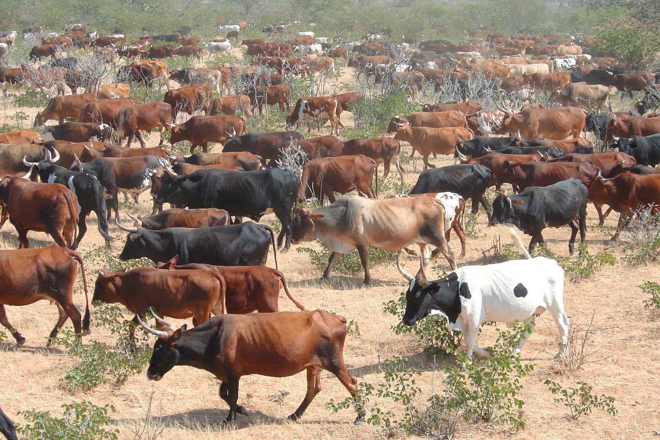
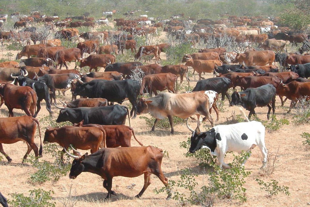
Daily combination of livestock from all households into a single herd to drive to different designated portions of the communal grazing area so that grass may recover to replenish its food reserves before being regrazed some months later.
2.2 Detailed description of the Technology
Description:
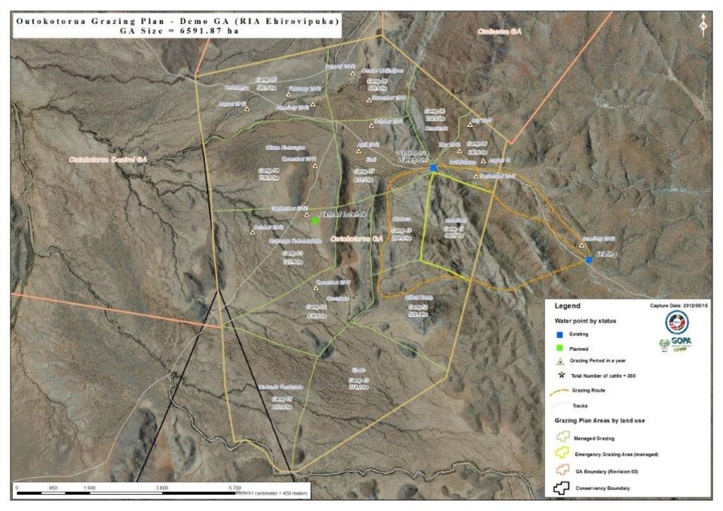
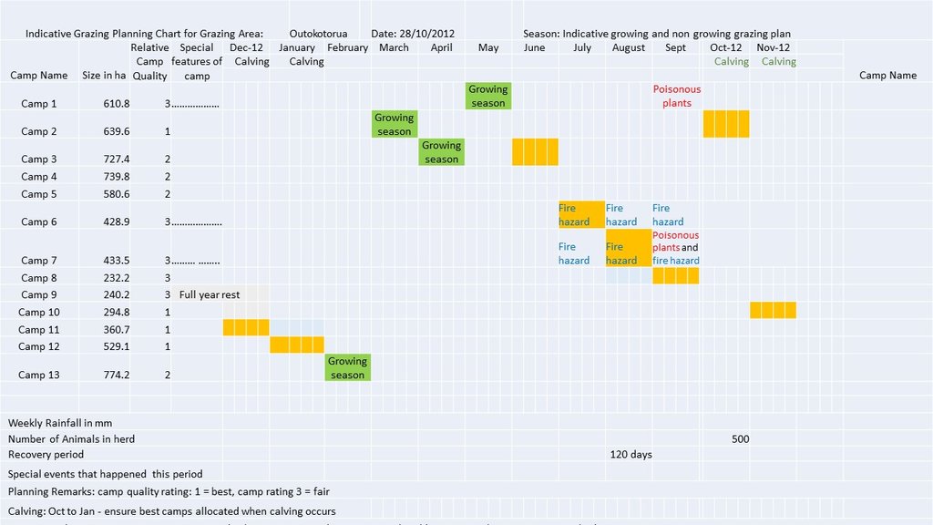
The technology is currently being applied in communal as well as commercial farms of Namibia. It is particularly effective in areas with no fences and areas with high incidence of stock theft and predator losses. The technology aims to replace continuous grazing with planned grazing which allows recovery of grass plants in the growing season and prepares the soil and grass plants for the upcoming rainy season during the non growing season. In addition fixed carrying capacities are replaced by flexible stocking rates which track availability of forage. Two grazing plans are developed per year, one when perennial grasses are growing and one when they are dormant. The grazing plans may change depending on the season and unanticipated events such as fire. During the growing season a grazing plan is in place that ensures plants are not regrazed before they have recovered their root reserves and that animal performance is good. In the non growing season animal numbers are adjusted to ensure there is sufficient grass to last until rains are reliably expected. Several selections are planned for to ensure animal performance is good.
The grazing plans must take into account all factors that affect the livestock performance as well as the farmer. These factors include first rains, natural pans, animal performance, ensuring good quality forage for cows prior to bulling, poisonous plants, time for vaccinations, where the livestock should be when the farmer is on leave etc. Once the plan has been developed, the animals are herded using low stress handling techniques according to the plan to various parts of the farm or communal grazing area. Moving livestock by herding enables fire breaks to be created by deliberate overtrampling. Each night the livestock are brought back to a kraal where they are kept overnight. Watering of livestock can take place in the kraal at night or in the morning or in the field depending on water availability. This process is repeated day after day.
At the end of each growing season the amount of forage available to the current herd is estimated and animal numbers are adjusted to ‘ensure’ that rains will have been received whilst there is still sufficient forage for the livestock and leaving enough soil cover to feed the soil organisms and protect the soil. Deciding when the forager grown in the last growing season will run out must be done using a method that farmers relate to. Farmers may decide to meet and reach consensus on this based on their knowledge of the effectiveness of rainfall during this season and past experience. If it is decided that there is sufficient food to see the animals through until the next rains can be expected, then farmers have enough forage and may even be able to re-stock if there is a food excess. If however a forage shortage is expected, because too little grass was grown in the last growing season to see them through to the next rains, then de-stocking is needed. The severity of the forage shortage determines how many livestock can be carried on this land during this non-growing season. Again farmers can reach consensus on this. Deciding whose animals to sell and how many is always a thorny issue so farmers will always move excessive animals to other areas if possible or sell unproductive animals first if needed.
2.3 Photos of the Technology
2.4 Videos of the Technology
Comments, short description:
Combined herding to manage communal grazing
www.youtube.com/watch?v=xNyFkDUH6MQ
Date:
2007
Location:
Erora
Name of videographer:
Andrew Botelle
Comments, short description:
Stress-free herding
www.youtube.com/watch?v=3Ey5v40KtkI
Date:
2007
Location:
Erora
Name of videographer:
Andrew Botelle
Comments, short description:
Managing water flow to repair gully erosion
www.youtube.com/watch?v=6C4V_Cib8ts
Date:
23/04/2015
Location:
Erora
Name of videographer:
Andrew Botelle
2.5 Country/ region/ locations where the Technology has been applied and which are covered by this assessment
Country:
Namibia
Region/ State/ Province:
Kunene Region
Further specification of location:
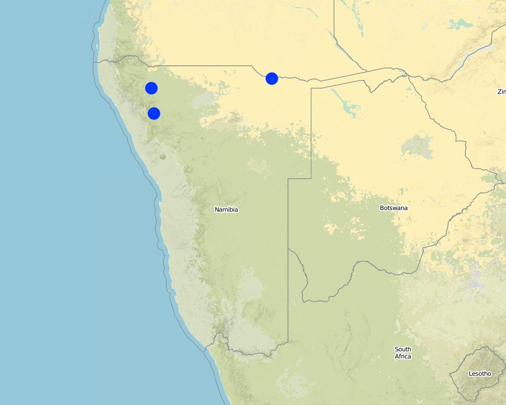
Communal grazing areas of Erora, Outokotorua and Nsindi
Map
×2.6 Date of implementation
Indicate year of implementation:
2004
2.7 Introduction of the Technology
Specify how the Technology was introduced:
- through projects/ external interventions
Comments (type of project, etc.):
Community projects facilitated by NGO "Conservation Agriculture Namibia"
3. Classification of the SLM Technology
3.1 Main purpose(s) of the Technology
- improve production
- reduce, prevent, restore land degradation
- conserve ecosystem
- protect a watershed/ downstream areas – in combination with other Technologies
- preserve/ improve biodiversity
- reduce risk of disasters
- adapt to climate change/ extremes and its impacts
- mitigate climate change and its impacts
- create beneficial economic impact
- create beneficial social impact
- Reduce human-wildlife conflict
3.2 Current land use type(s) where the Technology is applied

Grazing land
Extensive grazing land:
- Semi-nomadism/ pastoralism
Main animal species and products:
Livestock, increased forage production, improved animal performance
3.3 Further information about land use
Water supply for the land on which the Technology is applied:
- rainfed
Number of growing seasons per year:
- 1
Livestock density (if relevant):
Livestock density is high as a result of herding, but stocking rate varies
3.4 SLM group to which the Technology belongs
- pastoralism and grazing land management
3.5 Spread of the Technology
Specify the spread of the Technology:
- evenly spread over an area
If the Technology is evenly spread over an area, indicate approximate area covered:
- 100-1,000 km2
Comments:
Animals are herded over the entire area – except areas that are too steep for livestock to walk up.
3.6 SLM measures comprising the Technology

management measures
- M4: Major change in timing of activities
Comments:
The technology does not involve a change in land use. The grazing plan means that livestock will only be on a particular piece of land twice in any given year (once in the growing season and once in the non growing season). The animal density is however high, leading to increased impact for a very short period.
3.7 Main types of land degradation addressed by the Technology

soil erosion by water
- Wt: loss of topsoil/ surface erosion
- Wg: gully erosion/ gullying
- Wo: offsite degradation effects

soil erosion by wind
- Et: loss of topsoil

physical soil deterioration
- Pk: slaking and crusting

biological degradation
- Bc: reduction of vegetation cover
- Bq: quantity/ biomass decline
- Bs: quality and species composition/ diversity decline
- Bl: loss of soil life

water degradation
- Ha: aridification
- Hs: change in quantity of surface water
- Hg: change in groundwater/aquifer level
Comments:
The control of over-trampling which otherwise leads to rill and gulley erosion
3.8 Prevention, reduction, or restoration of land degradation
Specify the goal of the Technology with regard to land degradation:
- restore/ rehabilitate severely degraded land
Comments:
Land is severely degraded but can be restored by change in management
4. Technical specifications, implementation activities, inputs, and costs
4.1 Technical drawing of the Technology
4.2 Technical specifications/ explanations of technical drawing
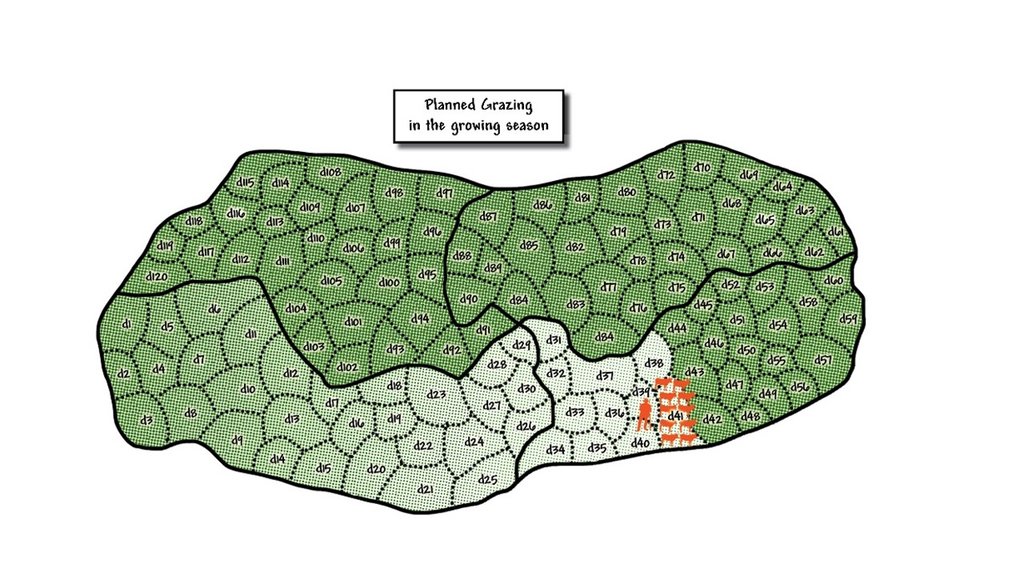
Schematic diagram of planned grazing of a growing season grazing plan. In this diagram grazing started in the bottom left hand camp, marked d1, and the livestock were grazed in this area for this day. The next day the herd of livestock were taken to the area marked d2 and grazed there. This continued until day 41 where the livestock are currently. If deviations from plan occur then the actual grazing map is marked according to what actually happened. This is the map that helps inform next year's grazing plan to avoid using certain camps at the same time of year. The degree of greenness in the diagram indicates the amount of recovery of grass since being grazed. It is lightest in the area just grazed, marked d40. By the time the herd reaches day 120, which has the darkest green indicating readiness to be re-grazed, then the grass in the area marked d1 was planned to have recovered sufficiently to be regrazed. This plan has a built in recovery period of 120 days. It is possible that growth rates are slower than expected and it may be necessary to reduce numbers of cattle in the herd to slow down the movement to ensure the desired recovery period is achieved.
4.3 General information regarding the calculation of inputs and costs
Specify how costs and inputs were calculated:
- per Technology area
Indicate size and area unit:
5000 ha
Specify currency used for cost calculations:
- US Dollars
Indicate average wage cost of hired labour per day:
USD 4
4.4 Establishment activities
| Activity | Type of measure | Timing | |
|---|---|---|---|
| 1. | Three meetings for mobilisation of communities | Management | Month 1 |
| 2. | Exchange visit to local farmers using this practise | Management | Month 4 |
| 3. | Assess water infrastructure, site and drill and install additional water point | Structural | Month 6 |
| 4. | Grazing planning meeting with stakeholders | Management | After adequate grass growth to enable planned grazing |
| 5. | Appoint, equip and train herders | Management | After 4 |
| 6. | Planning meeting and determination of starting date | Management | After 5 |
| 7. | Build overnight kraals at new water points | Structural | When needed |
| 8. | Build temporary kraals for improved grass growth | Structural | When needed |
4.5 Costs and inputs needed for establishment
| Specify input | Unit | Quantity | Costs per Unit | Total costs per input | % of costs borne by land users | |
|---|---|---|---|---|---|---|
| Labour | Six herders (four on duty per day) for 400 cattle | Months | 6.0 | 77.0 | 462.0 | 100.0 |
| Labour | One manager | Month | 1.0 | 115.0 | 115.0 | 100.0 |
| Equipment | Overalls, boots and hat that may need replacement after one year | Set | 7.0 | 100.0 | 700.0 | 100.0 |
| Construction material | Housing for herders built from mud and dung | Shelter | 3.0 | 100.0 | 300.0 | 100.0 |
| Other | Laminated grazing chart and map per year | Document | 2.0 | 10.0 | 20.0 | |
| Total costs for establishment of the Technology | 1597.0 | |||||
If land user bore less than 100% of costs, indicate who covered the remaining costs:
Grazing maps and charts prodcuded by CAN (support NGO), but will be taken over soon by farmers
4.6 Maintenance/ recurrent activities
| Activity | Type of measure | Timing/ frequency | |
|---|---|---|---|
| 1. | Daily herding, watering of livestock and health checks and treatment | Management | Daily |
| 2. | Maintenance of kraals and water points | Structural | Quartery |
4.7 Costs and inputs needed for maintenance/ recurrent activities (per year)
| Specify input | Unit | Quantity | Costs per Unit | Total costs per input | % of costs borne by land users | |
|---|---|---|---|---|---|---|
| Labour | Six herders (four on duty per day) for 400 cattle | Months | 6.0 | 77.0 | 462.0 | 100.0 |
| Labour | One manager | Month | 1.0 | 115.0 | 115.0 | 100.0 |
| Equipment | Overalls, boots and hat, replaced annually | Set | 7.0 | 100.0 | 700.0 | 100.0 |
| Construction material | Maintenance of clay and dung housing for herders | Shelters | 3.0 | 100.0 | 300.0 | 100.0 |
| Other | Diesel for pumping water per month | Litres | 100.0 | 1.0 | 100.0 | 100.0 |
| Other | Laminated grazing chart and map per year | Documents | 2.0 | 10.0 | 20.0 | 100.0 |
| Total costs for maintenance of the Technology | 1697.0 | |||||
4.8 Most important factors affecting the costs
Describe the most determinate factors affecting the costs:
Appreciation by land users that investment in herders will pay back, especially from the second year onwards.
5. Natural and human environment
5.1 Climate
Annual rainfall
- < 250 mm
- 251-500 mm
- 501-750 mm
- 751-1,000 mm
- 1,001-1,500 mm
- 1,501-2,000 mm
- 2,001-3,000 mm
- 3,001-4,000 mm
- > 4,000 mm
Specifications/ comments on rainfall:
Summer rainfall December-March
Indicate the name of the reference meteorological station considered:
Opuwo
Agro-climatic zone
- arid
5.2 Topography
Slopes on average:
- flat (0-2%)
- gentle (3-5%)
- moderate (6-10%)
- rolling (11-15%)
- hilly (16-30%)
- steep (31-60%)
- very steep (>60%)
Landforms:
- plateau/plains
- ridges
- mountain slopes
- hill slopes
- footslopes
- valley floors
Altitudinal zone:
- 0-100 m a.s.l.
- 101-500 m a.s.l.
- 501-1,000 m a.s.l.
- 1,001-1,500 m a.s.l.
- 1,501-2,000 m a.s.l.
- 2,001-2,500 m a.s.l.
- 2,501-3,000 m a.s.l.
- 3,001-4,000 m a.s.l.
- > 4,000 m a.s.l.
Indicate if the Technology is specifically applied in:
- not relevant
5.3 Soils
Soil depth on average:
- very shallow (0-20 cm)
- shallow (21-50 cm)
- moderately deep (51-80 cm)
- deep (81-120 cm)
- very deep (> 120 cm)
Soil texture (topsoil):
- coarse/ light (sandy)
Soil texture (> 20 cm below surface):
- medium (loamy, silty)
Topsoil organic matter:
- low (<1%)
5.4 Water availability and quality
Ground water table:
> 50 m
Availability of surface water:
medium
Water quality (untreated):
good drinking water
Is water salinity a problem?
No
Is flooding of the area occurring?
Yes
Regularity:
episodically
5.5 Biodiversity
Species diversity:
- medium
Habitat diversity:
- medium
5.6 Characteristics of land users applying the Technology
Sedentary or nomadic:
- Sedentary
- Semi-nomadic
Market orientation of production system:
- mixed (subsistence/ commercial
Off-farm income:
- 10-50% of all income
Relative level of wealth:
- average
Individuals or groups:
- groups/ community
Level of mechanization:
- manual work
Gender:
- women
- men
Age of land users:
- middle-aged
Indicate other relevant characteristics of the land users:
In dry years all livestock may move to another cattle post. But they return to the sedentary site as their main grazing area. A significant number of land users take up employment in the nearest town.
5.7 Average area of land owned or leased by land users applying the Technology
- < 0.5 ha
- 0.5-1 ha
- 1-2 ha
- 2-5 ha
- 5-15 ha
- 15-50 ha
- 50-100 ha
- 100-500 ha
- 500-1,000 ha
- 1,000-10,000 ha
- > 10,000 ha
Is this considered small-, medium- or large-scale (referring to local context)?
- medium-scale
Comments:
Communal land is not owned or leased, but the community has rights to use it for agricultural purposes
5.8 Land ownership, land use rights, and water use rights
Land ownership:
- state
Land use rights:
- communal (organized)
Water use rights:
- communal (organized)
Comments:
Land is communal and organised but no rights to enforce management are yet in place through formal structures.
5.9 Access to services and infrastructure
health:
- poor
- moderate
- good
education:
- poor
- moderate
- good
technical assistance:
- poor
- moderate
- good
employment (e.g. off-farm):
- poor
- moderate
- good
markets:
- poor
- moderate
- good
energy:
- poor
- moderate
- good
roads and transport:
- poor
- moderate
- good
drinking water and sanitation:
- poor
- moderate
- good
financial services:
- poor
- moderate
- good
6. Impacts and concluding statements
6.1 On-site impacts the Technology has shown
Socio-economic impacts
Production
fodder production
animal production
risk of production failure
land management
Comments/ specify:
Improved, not simplified
Water availability and quality
water availability for livestock
Income and costs
expenses on agricultural inputs
farm income
economic disparities
workload
Socio-cultural impacts
food security/ self-sufficiency
land use/ water rights
community institutions
SLM/ land degradation knowledge
conflict mitigation
Ecological impacts
Water cycle/ runoff
surface runoff
evaporation
Soil
soil moisture
soil cover
soil loss
soil crusting/ sealing
nutrient cycling/ recharge
Biodiversity: vegetation, animals
Vegetation cover
plant diversity
animal diversity
Climate and disaster risk reduction
drought impacts
fire risk
micro-climate
6.2 Off-site impacts the Technology has shown
Community's cattle no longer graze on land of neighbouring communities
6.3 Exposure and sensitivity of the Technology to gradual climate change and climate-related extremes/ disasters (as perceived by land users)
Gradual climate change
Gradual climate change
| Season | Type of climatic change/ extreme | How does the Technology cope with it? | |
|---|---|---|---|
| annual temperature | increase | moderately | |
| annual rainfall | decrease | moderately |
Climate-related extremes (disasters)
Meteorological disasters
| How does the Technology cope with it? | |
|---|---|
| local thunderstorm | well |
Climatological disasters
| How does the Technology cope with it? | |
|---|---|
| drought | moderately |
| land fire | well |
6.4 Cost-benefit analysis
How do the benefits compare with the establishment costs (from land users’ perspective)?
Short-term returns:
positive
Long-term returns:
very positive
How do the benefits compare with the maintenance/ recurrent costs (from land users' perspective)?
Short-term returns:
very positive
Long-term returns:
very positive
Comments:
The ability to bring back perennial grasses results in higher stocking rates, less drought risk and better quality animals, therefore higher income over time and therefore a good cost benefit analysis.
6.5 Adoption of the Technology
- 1-10%
If available, quantify (no. of households and/ or area covered):
20,000 ha
Of all those who have adopted the Technology, how many have did so spontaneously, i.e. without receiving any material incentives/ payments?
- 0-10%
Comments:
This is a key issue undergoing lobbying of government and the communal farmers union to establish through a consultative process legislation that enables grazing plans to be enforced from within and from outside. This is lacking at the moment.
6.6 Adaptation
Has the Technology been modified recently to adapt to changing conditions?
Yes
other (specify):
Adaptive management
Specify adaptation of the Technology (design, material/ species, etc.):
Addition of erosion control and overnight kraaling to assist with gully control. Refining re-planning in response to monitored results that show deviation from aims.
6.7 Strengths/ advantages/ opportunities of the Technology
| Strengths/ advantages/ opportunities in the land user’s view |
|---|
| It is cost effective, real improvement is seen in grass production while livestock losses to predators are significantly reduced. |
| For absentee owners they can leave a manager and herders in place to get on with the work and this can be easily evaluated after time since animals wondering around leave evidence. |
| Livestock are better cared for as they used to be and a sense of community has been restored. |
| Strengths/ advantages/ opportunities in the compiler’s or other key resource person’s view |
|---|
| This is a viable and upscaleable technology for both communal and commercial farmland in Namibia and beyond. |
| It addresses the root cause of livestock related degradation and at a global scale can have a significant impact on mitigating climate change if all the degraded rangelands of the dry climates of the world are restored by using the principles embodied in this approach – which has been adopted in the National Rangeland Management Policy and Strategy. Moreover it can improve the quality of lives of millions of people who live in areas where livestock is the only viable land use. |
| This is a true triple bottom line technology that improves the resource base whilst increasing profits and enbables an improved quality of life of residents. |
6.8 Weaknesses/ disadvantages/ risks of the Technology and ways of overcoming them
| Weaknesses/ disadvantages/ risks in the land user’s view | How can they be overcome? |
|---|---|
| Herders are difficult to find, train and keep. | National level vocational training of herders is required. |
| Water infrastructure tends to result in overtrampling of the same routes. | The Directorate of Rural Water Supply should change its water specifications to include the provision of water for livestock – which can be cheap and effective. |
| Grass poaching takes place by neighbours and the majority will of people in an area is sometimes overrun by a small minority. | Farmers Unions must address these issues and get enforceable mechanisms in place for improved rangeland management. |
| Weaknesses/ disadvantages/ risks in the compiler’s or other key resource person’s view | How can they be overcome? |
|---|---|
| There is insufficient national buy-in from line ministries in terms of implementation to address many of the issues that have been raised. | Line ministries should support implementation to address these problems. Joint implementation, joint review and adaptation by government, unions, farmers and support providers will assist in solving many issues for resource base improvement. |
7. References and links
7.1 Methods/ sources of information
- interviews with SLM specialists/ experts
7.2 References to available publications
Title, author, year, ISBN:
Holistic mangement, Savory, A. & Butterfield, J., 1991
Available from where? Costs?
Island Press
7.3 Links to relevant information which is available online
Title/ description:
Volkmann, W. (2011). Community based rangeland and livestock management. Windhoek: GOPA-CBRLM.
URL:
https://rmportal.net/groups/cbrlm/cbrlm-for-review/namibia-community-based-rangeland-livestock-management-cbrlm-2nd-edition/view
Links and modules
Expand all Collapse allLinks
No links
Modules
No modules


