Recharge well [Tunisia]
- Creation:
- Update:
- Compiler: Mongi Ben Zaied
- Editor: –
- Reviewers: Deborah Niggli, Donia Mühlematter
Puits de recharge (French)
technologies_1412 - Tunisia
View sections
Expand all Collapse all1. General information
1.2 Contact details of resource persons and institutions involved in the assessment and documentation of the Technology
Key resource person(s)
SLM specialist:
Chniter Mongi
Commissariats Régionaux au Développement Agricole CRDA
Tunisia
SLM specialist:
Yahyaoui Houcine
Commissariats Régionaux au Développement Agricole CRDA
Tunisia
SLM specialist:
Name of project which facilitated the documentation/ evaluation of the Technology (if relevant)
DESIRE (EU-DES!RE)Name of project which facilitated the documentation/ evaluation of the Technology (if relevant)
Book project: Water Harvesting – Guidelines to Good Practice (Water Harvesting)Name of the institution(s) which facilitated the documentation/ evaluation of the Technology (if relevant)
Commissariats Régionaux au Développement Agricole (CRDA) - TunisiaName of the institution(s) which facilitated the documentation/ evaluation of the Technology (if relevant)
Institut des Régions Arides de Médenine (Institut des Régions Arides de Médenine) - Tunisia1.3 Conditions regarding the use of data documented through WOCAT
The compiler and key resource person(s) accept the conditions regarding the use of data documented through WOCAT:
Yes
1.4 Declaration on sustainability of the described Technology
Is the Technology described here problematic with regard to land degradation, so that it cannot be declared a sustainable land management technology?
No
1.5 Reference to Questionnaire(s) on SLM Approaches (documented using WOCAT)
Dryland watershed management approach [Tunisia]
Integrated land and water management approach, including vegetative, management, and agronomic measure
- Compiler: Naceur Mahdi
2. Description of the SLM Technology
2.1 Short description of the Technology
Definition of the Technology:
A recharge well comprises a drilled hole, up to 30-40 m deep that reaches the water table, and a surrounding filter used to allow the direct injection of floodwater into the aquifer.
2.2 Detailed description of the Technology
Description:
The main worldwide used methods to enhance groundwater replenishment are through recharge basins or recharge wells. Though groundwater recharge aiming at storage of water in the periods of abundance for recovery in times of drought has a long history dating back millennia, the recharge wells began to be used only in the twentieth century, especially during the Second World War following concerns on attacks of the water supply facilities. Its use was extended later to sea intrusion control, treated waste water, water harvesting in the dry areas, and strategic water storage.
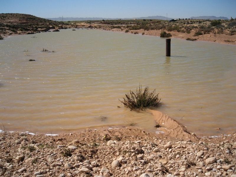
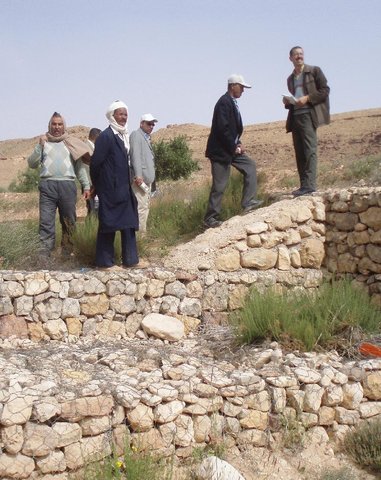
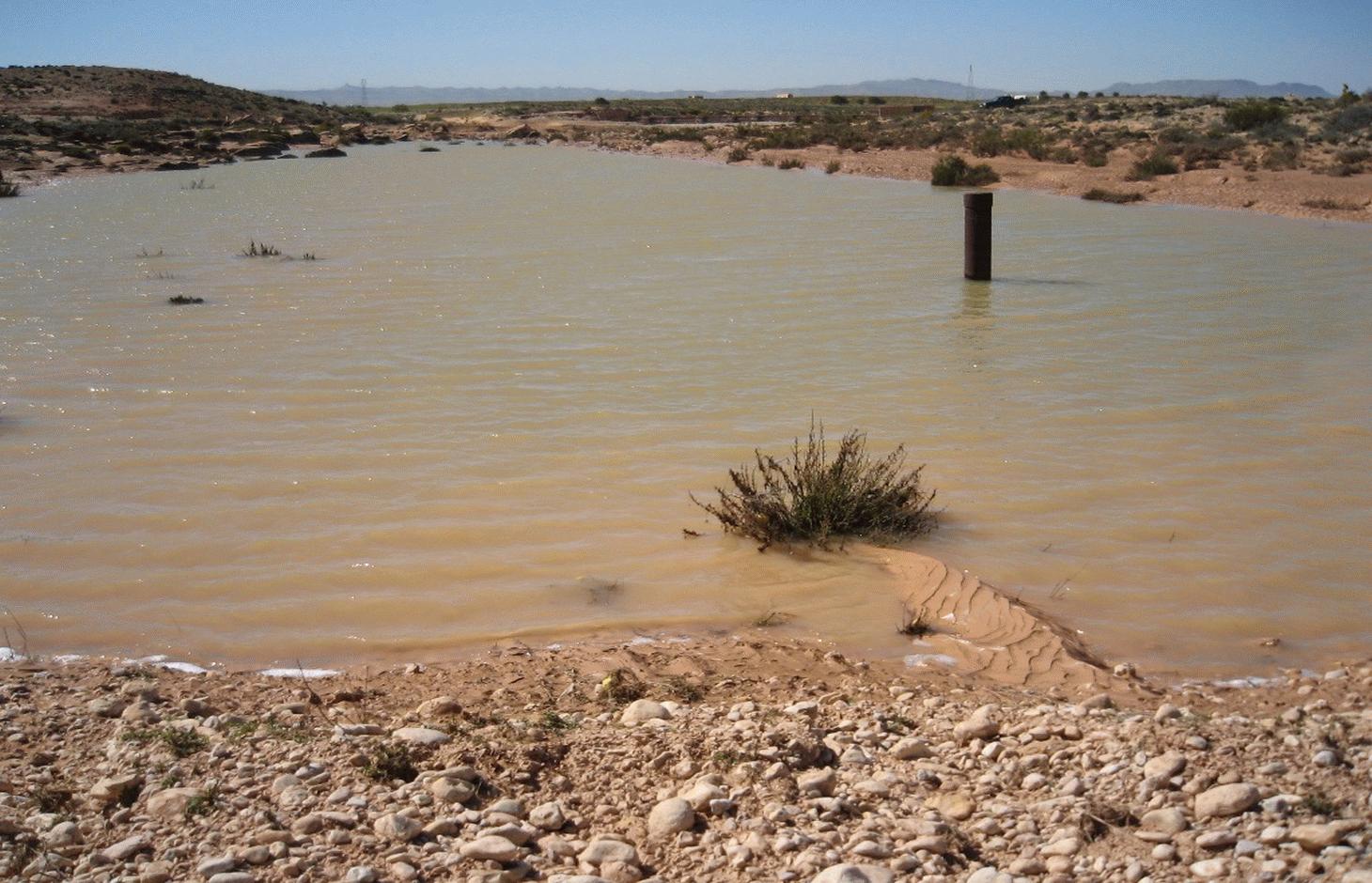
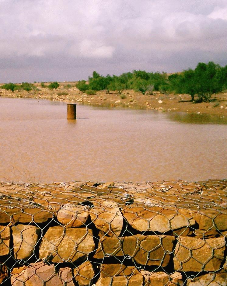
Purpose of the Technology: Recharge wells are used in combination with gabion check dams to enhance the infiltration of floodwater into the aquifer. In areas where the permeability of the underlying bedrock in front of a gabion is judged too low, recharge wells could be installed in wadi (ephemeral river) beds. Water is retained by the gabion check dam and it flows through the recharge well allowing accelerated percolation into the aquifer.
Establishment / maintenance activities and inputs: A recharge well consists of a long inner tube surrounded by an outer tube, the circumference of which ranges between 1 and 2 m. The area between the tubes is filled with river bed gravel which acts as a sediment filter. Water enters the well through rectangular-shaped openings (almost 20 cm long and a few mm in width) located in the outer tube, and it flows in the inner hole having passed through the gravel and the rectangular shaped openings of the dill hole. The above-ground height is around 2 to 3 m whereas the depth is linked to the depth of the water table (normally up to 40 m). The drill hole connects directly with the aquifer, where it is connected either directly with the water table or indirectly via cracks. Pond volume is dependent on the size of the gabion check dam but generally ranges between 500 and 3000 m3. The filtered water can directly flow into the aquifer at a rate exceeding what would occur naturally through the soil and the underlying strata.
The design should be conducted primarily by a hydrogeologist and a soil and water conservation specialist in order to determine the potential sites and the required drilling equipment. Drilling needs to be carried out by a specialized company.
Depending on the geological setting, the overall cost is around 5000 to 10000 US$. The recharge wells are used to recharge the deep groundwater aquifers, which are mainly exploited by government agencies. However, private irrigated farms are benefiting indirectly by increased groundwater availability.
Natural / human environment: This technique has been first tried for the replenishment of the Zeuss-Koutine aquifer (south east Tunisia).
2.3 Photos of the Technology
Media Gallery
2.5 Country/ region/ locations where the Technology has been applied and which are covered by this assessment
Country:
Tunisia
Region/ State/ Province:
Medenine
Further specification of location:
Medenine nord
Specify the spread of the Technology:
- evenly spread over an area
If precise area is not known, indicate approximate area covered:
- 10-100 km2
Map
×2.6 Date of implementation
If precise year is not known, indicate approximate date:
- 10-50 years ago
2.7 Introduction of the Technology
Specify how the Technology was introduced:
- through projects/ external interventions
3. Classification of the SLM Technology
3.1 Main purpose(s) of the Technology
- reduce, prevent, restore land degradation
- protect a watershed/ downstream areas – in combination with other Technologies
- create beneficial economic impact
3.2 Current land use type(s) where the Technology is applied
Land use mixed within the same land unit:
Yes
Specify mixed land use (crops/ grazing/ trees):
- Agro-pastoralism (incl. integrated crop-livestock)

Cropland
- Tree and shrub cropping
Number of growing seasons per year:
- 1
Specify:
Longest growing period in days: 180Longest growing period from month to month: Oct - Apr

Grazing land
Extensive grazing:
- Semi-nomadic pastoralism
Comments:
Major land use problems (compiler’s opinion): Runoff water loss, riverbank erosion, flooding risk, aridity
Major land use problems (land users’ perception): water loss
Constraints of wadi beds
3.3 Has land use changed due to the implementation of the Technology?
Has land use changed due to the implementation of the Technology?
- No (Continue with question 3.4)
3.4 Water supply
Water supply for the land on which the Technology is applied:
- rainfed
3.5 SLM group to which the Technology belongs
- water harvesting
- ground water management
3.6 SLM measures comprising the Technology

structural measures
- S11: Others
Comments:
Main measures: structural measures
3.7 Main types of land degradation addressed by the Technology

soil erosion by water
- Wr: riverbank erosion
- Wo: offsite degradation effects

water degradation
- Ha: aridification
- Hq: decline of groundwater quality
Comments:
Main type of degradation addressed: Ha: aridification
Secondary types of degradation addressed: Wr: riverbank erosion, Wo: offsite degradation effects, Hq: decline of groundwater quality
Main causes of degradation: over abstraction / excessive withdrawal of water (for irrigation, industry, etc.)
Secondary causes of degradation: disturbance of water cycle (infiltration / runoff), Heavy / extreme rainfall (intensity/amounts)
3.8 Prevention, reduction, or restoration of land degradation
Specify the goal of the Technology with regard to land degradation:
- prevent land degradation
- reduce land degradation
Comments:
Main goals: prevention of land degradation
Secondary goals: mitigation / reduction of land degradation
4. Technical specifications, implementation activities, inputs, and costs
4.1 Technical drawing of the Technology
Author:
Ouessar M., Medenine, Tunisia
4.2 General information regarding the calculation of inputs and costs
other/ national currency (specify):
TND
If relevant, indicate exchange rate from USD to local currency (e.g. 1 USD = 79.9 Brazilian Real): 1 USD =:
1.3
Indicate average wage cost of hired labour per day:
10.00
4.3 Establishment activities
| Activity | Timing (season) | |
|---|---|---|
| 1. | Drilling | |
| 2. | Installation |
4.4 Costs and inputs needed for establishment
| Specify input | Unit | Quantity | Costs per Unit | Total costs per input | % of costs borne by land users | |
|---|---|---|---|---|---|---|
| Labour | Labour | ha | 1.0 | 7000.0 | 7000.0 | |
| Construction material | ha | 1.0 | 1000.0 | 1000.0 | ||
| Total costs for establishment of the Technology | 8000.0 | |||||
| Total costs for establishment of the Technology in USD | 6153.85 | |||||
Comments:
Duration of establishment phase: 3 month(s)
4.5 Maintenance/ recurrent activities
| Activity | Timing/ frequency | |
|---|---|---|
| 1. | Desilting of the filter | Ounce in 1-3years (floods) |
| 2. | Repairs |
4.6 Costs and inputs needed for maintenance/ recurrent activities (per year)
| Specify input | Unit | Quantity | Costs per Unit | Total costs per input | % of costs borne by land users | |
|---|---|---|---|---|---|---|
| Labour | Labour | ha | 1.0 | 500.0 | 500.0 | |
| Construction material | ha | 1.0 | 100.0 | 100.0 | ||
| Total costs for maintenance of the Technology | 600.0 | |||||
| Total costs for maintenance of the Technology in USD | 461.54 | |||||
4.7 Most important factors affecting the costs
Describe the most determinate factors affecting the costs:
Labour is the most determining factor affecting the costs.
5. Natural and human environment
5.1 Climate
Annual rainfall
- < 250 mm
- 251-500 mm
- 501-750 mm
- 751-1,000 mm
- 1,001-1,500 mm
- 1,501-2,000 mm
- 2,001-3,000 mm
- 3,001-4,000 mm
- > 4,000 mm
Agro-climatic zone
- arid
Thermal climate class: subtropics
5.2 Topography
Slopes on average:
- flat (0-2%)
- gentle (3-5%)
- moderate (6-10%)
- rolling (11-15%)
- hilly (16-30%)
- steep (31-60%)
- very steep (>60%)
Landforms:
- plateau/plains
- ridges
- mountain slopes
- hill slopes
- footslopes
- valley floors
Altitudinal zone:
- 0-100 m a.s.l.
- 101-500 m a.s.l.
- 501-1,000 m a.s.l.
- 1,001-1,500 m a.s.l.
- 1,501-2,000 m a.s.l.
- 2,001-2,500 m a.s.l.
- 2,501-3,000 m a.s.l.
- 3,001-4,000 m a.s.l.
- > 4,000 m a.s.l.
Indicate if the Technology is specifically applied in:
- not relevant
5.3 Soils
Soil depth on average:
- very shallow (0-20 cm)
- shallow (21-50 cm)
- moderately deep (51-80 cm)
- deep (81-120 cm)
- very deep (> 120 cm)
Soil texture (topsoil):
- medium (loamy, silty)
Topsoil organic matter:
- low (<1%)
If available, attach full soil description or specify the available information, e.g. soil type, soil PH/ acidity, Cation Exchange Capacity, nitrogen, salinity etc.
Soil fertility is very low
Soil drainage / infiltration is medium
Soil water storage is medium
5.4 Water availability and quality
Ground water table:
5-50 m
Availability of surface water:
poor/ none
Water quality (untreated):
poor drinking water (treatment required)
Is water salinity a problem?
Yes
Is flooding of the area occurring?
Yes
Regularity:
episodically
Comments and further specifications on water quality and quantity:
Seasonal fluctuations: Availability of surface water is poor/none but with periods of excess (e.g. flood)
5.5 Biodiversity
Species diversity:
- medium
Habitat diversity:
- low
5.6 Characteristics of land users applying the Technology
Sedentary or nomadic:
- Sedentary
- Semi-nomadic
Market orientation of production system:
- mixed (subsistence/ commercial)
Off-farm income:
- > 50% of all income
Relative level of wealth:
- average
Individuals or groups:
- employee (company, government)
Level of mechanization:
- manual work
Gender:
- men
Age of land users:
- middle-aged
- elderly
Indicate other relevant characteristics of the land users:
Population density: 10-50 persons/km2
Annual population growth: 0.5% - 1%
70% of the land users are average wealthy and own 75% of the land.
5.7 Average area of land used by land users applying the Technology
- < 0.5 ha
- 0.5-1 ha
- 1-2 ha
- 2-5 ha
- 5-15 ha
- 15-50 ha
- 50-100 ha
- 100-500 ha
- 500-1,000 ha
- 1,000-10,000 ha
- > 10,000 ha
Is this considered small-, medium- or large-scale (referring to local context)?
- small-scale
5.8 Land ownership, land use rights, and water use rights
Land ownership:
- state
Land use rights:
- communal (organized)
Water use rights:
- communal (organized)
Comments:
The recharge wells are used to recharge the deep groundwater aquifers which are mainly exploited by the government agencies. However, private irrigated farms could benefit indirectly, by increased groundwater availability.
5.9 Access to services and infrastructure
health:
- poor
- moderate
- good
education:
- poor
- moderate
- good
technical assistance:
- poor
- moderate
- good
employment (e.g. off-farm):
- poor
- moderate
- good
markets:
- poor
- moderate
- good
energy:
- poor
- moderate
- good
roads and transport:
- poor
- moderate
- good
drinking water and sanitation:
- poor
- moderate
- good
financial services:
- poor
- moderate
- good
6. Impacts and concluding statements
6.1 On-site impacts the Technology has shown
Socio-economic impacts
Water availability and quality
drinking water availability
water availability for livestock
irrigation water availability
Socio-cultural impacts
SLM/ land degradation knowledge
conflict mitigation
Improved livelihoods and human well-being
Comments/ specify:
Increased availability of water for drinking, agriculture and livestock
Ecological impacts
Water cycle/ runoff
harvesting/ collection of water
groundwater table/ aquifer
Soil
salinity
Other ecological impacts
risks of contamination of aquifers
6.2 Off-site impacts the Technology has shown
water availability
downstream flooding
Comments/ specify:
In combination with gabion check dams
damage on public/ private infrastructure
Comments/ specify:
In combination with gabion check dams
Surface water to reach downstream areas
6.3 Exposure and sensitivity of the Technology to gradual climate change and climate-related extremes/ disasters (as perceived by land users)
Gradual climate change
Gradual climate change
| Season | increase or decrease | How does the Technology cope with it? | |
|---|---|---|---|
| annual temperature | increase | well |
Climate-related extremes (disasters)
Meteorological disasters
| How does the Technology cope with it? | |
|---|---|
| local rainstorm | well |
| local windstorm | well |
Climatological disasters
| How does the Technology cope with it? | |
|---|---|
| drought | well |
Other climate-related consequences
Other climate-related consequences
| How does the Technology cope with it? | |
|---|---|
| reduced growing period | well |
| extreme floods | not well |
6.4 Cost-benefit analysis
How do the benefits compare with the establishment costs (from land users’ perspective)?
Short-term returns:
very positive
Long-term returns:
positive
How do the benefits compare with the maintenance/ recurrent costs (from land users' perspective)?
Short-term returns:
very positive
Long-term returns:
positive
Comments:
Long-term benefits are slightly reduced due to silting problems.
6.5 Adoption of the Technology
Of all those who have adopted the Technology, how many did so spontaneously, i.e. without receiving any material incentives/ payments?
- 0-10%
Comments:
Comments on acceptance with external material support: It is solely constrcuted by the government agencies.
6.7 Strengths/ advantages/ opportunities of the Technology
| Strengths/ advantages/ opportunities in the land user’s view |
|---|
|
Replenishment of the aquifer How can they be sustained / enhanced? Good selection of the site and drilling methods |
| Strengths/ advantages/ opportunities in the compiler’s or other key resource person’s view |
|---|
| Enhance groundwater level and quality (reduce salinity) |
6.8 Weaknesses/ disadvantages/ risks of the Technology and ways of overcoming them
| Weaknesses/ disadvantages/ risks in the land user’s view | How can they be overcome? |
|---|---|
| Retain water for dowstreams users | Proper watershed management plan |
| Weaknesses/ disadvantages/ risks in the compiler’s or other key resource person’s view | How can they be overcome? |
|---|---|
| Silting up of the filter | Maintenance of the filters. |
| Malfunction due to aquifer geometry and characteristics | Good selection of the sites |
7. References and links
7.1 Methods/ sources of information
- compilation from reports and other existing documentation
When were the data compiled (in the field)?
10/06/2011
7.2 References to available publications
Title, author, year, ISBN:
Yahyaoui, H., Ouessar, M. 2000. Abstraction and recharge impacts on the ground water in the arid regions of Tunisia: Case of Zeuss-Koutine water table. UNU Desertification Series, 2: 72-78.
Available from where? Costs?
IRA, CRDA-Medenine, UNU
Title, author, year, ISBN:
Yahyaoui, H., Chaieb, H., Ouessar, M. 2002. Impact des travaux de conservation des eaux et des sols sur la recharge de la nappe de Zeuss-Koutine (Médenine: Sud-est tunisien). TRMP paper n° 40, Wageningen University, The Netherlands, pp: 71-86.
Available from where? Costs?
IRA, Wegeningen University (NL),
Title, author, year, ISBN:
Temmerman, S. 2004. Evaluation of the efficiency of recharge wells on the water supply to the water table in South Tunisia. Graduation dissertation, Ghent University, Belgium.
Available from where? Costs?
IRA, Gent University (BE)
Title, author, year, ISBN:
Genin, D., Guillaume, H., Ouessar, M., Ouled Belgacem, A., Romagny, B., Sghaier, M., Taamallah, H. (eds) 2006. Entre la désertification et le développement : la Jeffara tunisienne. CERES, Tunis, 351 pp.
Available from where? Costs?
IRA, IRD
Title, author, year, ISBN:
Ouessar M. 2007. Hydrological impacts of rainwater harvesting in wadi Oum Zessar watershed (Southern Tunisia). Ph.D. thesis, Faculty of Bioscience Engineering, Ghent University, Ghent, Belgium, 154 pp.
Available from where? Costs?
IRA, Gent University (BE)
Links and modules
Expand all Collapse allLinks
Dryland watershed management approach [Tunisia]
Integrated land and water management approach, including vegetative, management, and agronomic measure
- Compiler: Naceur Mahdi
Modules
No modules