
Cut-off drain [Thailand]
- Creation:
- Update:
- Compiler: Unknown User
- Editor: –
- Reviewers: Fabian Ottiger, Alexandra Gavilano
Rong rabai nam (Thai)
technologies_1405 - Thailand
View sections
Expand all Collapse all1. General information
1.2 Contact details of resource persons and institutions involved in the assessment and documentation of the Technology
Key resource person(s)
SLM specialist:
Tiparat Sutep
Doi Tung Highland Agricultural Extension Center
Thailand
SLM specialist:
Outarasak Vorachai
Doi Tung Highland Agricultural Extension Center
Thailand
SLM specialist:
Suksom Prasong
Highland Flower Growing Promotion Project
Thailand
1.3 Conditions regarding the use of data documented through WOCAT
The compiler and key resource person(s) accept the conditions regarding the use of data documented through WOCAT:
Yes
1.5 Reference to Questionnaire(s) on SLM Approaches (documented using WOCAT)
Cut-off drain [Thailand]
This approach is the 'way' or 'how' the cut-off drain has been implemented on steepland in northern Thailand.
- Compiler: Samran Sombatpanit
2. Description of the SLM Technology
2.1 Short description of the Technology
Definition of the Technology:
Cut-off drain is a drainage ditch dug to quickly drain water out of sloping agricultural land.
2.2 Detailed description of the Technology
Description:
The cut-off drain is the same thing described as 'diversion' or 'diversion ditch'. It is dug by hand-hoe, only one hoe wide in the first year and may expand wider in the second and third year. It is dug with gradient from 15-50% to facilitate drainaing of runoff, not to scour the soil. Note: 1. The width of one hoe is approx. 21 cm , 2. The dimension of the ditch may become 30-40 cm wide and deep after 3 years.
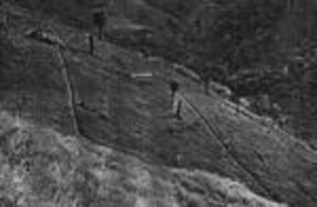
2.3 Photos of the Technology
Media Gallery
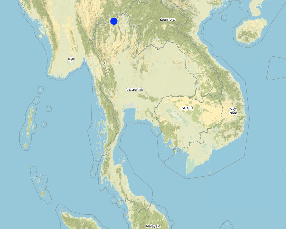
2.5 Country/ region/ locations where the Technology has been applied and which are covered by this assessment
Country:
Thailand
Region/ State/ Province:
Chiang Rai
Further specification of location:
Amphur Mae Fa Luang
Specify the spread of the Technology:
- evenly spread over an area
If precise area is not known, indicate approximate area covered:
- 10-100 km2
Comments:
Total area covered by the SLM Technology is 15 km2.
E-kaw, Lahu, Lisu, Mien, Khin, Thai Yai, Haw Chinese, H'mong. They have been doing this practice for a long time. The technology transfers from generation to generation.
Map
×2.6 Date of implementation
If precise year is not known, indicate approximate date:
- more than 50 years ago (traditional)
2.7 Introduction of the Technology
Specify how the Technology was introduced:
- as part of a traditional system (> 50 years)
Comments (type of project, etc.):
It is an original idea. No one knows how/when it was originated.
3. Classification of the SLM Technology
3.1 Main purpose(s) of the Technology
- reduce, prevent, restore land degradation
3.2 Current land use type(s) where the Technology is applied

Cropland
- Annual cropping
- Perennial (non-woody) cropping
- Tree and shrub cropping
Annual cropping - Specify crops:
- cereals - maize
- cereals - rice (upland)
Tree and shrub cropping - Specify crops:
- fruits, other
Number of growing seasons per year:
- 2
Specify:
Longest growing period in days: 120 Longest growing period from month to month: May - Aug Second longest growing period in days: 90 Second longest growing period from month to month: Sep - Nov

Grazing land
Extensive grazing:
- Nomadism
- Semi-nomadic pastoralism
Comments:
Major land use problems (compiler’s opinion): 1. There is soil erosion problem because of high terrain, 2. Lacking of land ownership (The whole land area is reserved forest), 3. Low price of agricultural produce,
Major land use problems (land users’ perception): 1. Lacking of land ownership, 2. Land users do not have Thai citizenship; less than 20 % have ID cards (not citizenship).
Nomadism: Yes
Semi-nomadism / pastoralism: Yes
3.5 SLM group to which the Technology belongs
- irrigation management (incl. water supply, drainage)
- water diversion and drainage
3.6 SLM measures comprising the Technology
3.7 Main types of land degradation addressed by the Technology

soil erosion by water
- Wt: loss of topsoil/ surface erosion
- Wg: gully erosion/ gullying
Comments:
Main type of degradation addressed: Wt: loss of topsoil / surface erosion, Wg: gully erosion / gullying
Main causes of degradation: deforestation / removal of natural vegetation (incl. forest fires), Lack of enforcement of legislation or authority
Secondary causes of degradation: other human induced causes (specify) (Agricultural activities), other natural causes (avalanches, volcanic eruptions, mud flows, highly susceptible natural resources, extreme topography, etc.) specify
3.8 Prevention, reduction, or restoration of land degradation
Specify the goal of the Technology with regard to land degradation:
- reduce land degradation
4. Technical specifications, implementation activities, inputs, and costs
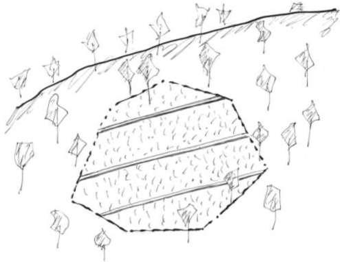
4.1 Technical drawing of the Technology
Technical specifications (related to technical drawing):
Average slope properties of a cut-off drain.
The cut-off drain is the same as 'diversion'. It is dug by hand hoe, only one hoe wide in the firs yer and may expand wider in the second year and third year. It is dug with gradient in order to facilitate draining of runoff, not to scour the soil. The gradient may vary from 3:20 (15%) to 1:2 (50%).
Note: The land may be cropped for 3 years and left for shrubs to grow for some years. Then farmers return to clear the land to grow crop again.
Location: Average slope properties of a cut-off drain.. Chiang Rai Province
Date: 1999
Technical knowledge required for field staff / advisors: low
Technical knowledge required for land users: low
Main technical functions: control of concentrated runoff: drain / divert, reduction of slope length
Structural measure: Cut-off drain
Vertical interval between structures (m): 3
Spacing between structures (m): 10
Depth of ditches/pits/dams (m): 0.4
Width of ditches/pits/dams (m): 0.4
Length of ditches/pits/dams (m): 40
Construction material (earth): It is the earth dug in situ.
Lateral gradient along the structure: 20%
Vegetation is used for stabilisation of structures.
Author:
Turkelboom
4.2 General information regarding the calculation of inputs and costs
other/ national currency (specify):
Baht
If relevant, indicate exchange rate from USD to local currency (e.g. 1 USD = 79.9 Brazilian Real): 1 USD =:
37.0
Indicate average wage cost of hired labour per day:
2.16
4.3 Establishment activities
| Activity | Timing (season) | |
|---|---|---|
| 1. | Digging of the ditch after land preparation | Before rainy season |
4.4 Costs and inputs needed for establishment
| Specify input | Unit | Quantity | Costs per Unit | Total costs per input | % of costs borne by land users | |
|---|---|---|---|---|---|---|
| Labour | Labour | ha | 1.0 | 4.32 | 4.32 | 100.0 |
| Total costs for establishment of the Technology | 4.32 | |||||
| Total costs for establishment of the Technology in USD | 0.12 | |||||
Comments:
Duration of establishment phase: 12 month(s)
4.5 Maintenance/ recurrent activities
| Activity | Timing/ frequency | |
|---|---|---|
| 1. | Dredging up the earth that fell down when preparing for next crop | Before rainy season/Annually |
4.6 Costs and inputs needed for maintenance/ recurrent activities (per year)
| Specify input | Unit | Quantity | Costs per Unit | Total costs per input | % of costs borne by land users | |
|---|---|---|---|---|---|---|
| Labour | Labour | ha | 1.0 | 4.32 | 4.32 | 100.0 |
| Total costs for maintenance of the Technology | 4.32 | |||||
| Total costs for maintenance of the Technology in USD | 0.12 | |||||
Comments:
Cost per ha of land protected
4.7 Most important factors affecting the costs
Describe the most determinate factors affecting the costs:
Steep slope will require larger number of the cut-off drains, thus affecting the cost.
5. Natural and human environment
5.1 Climate
Annual rainfall
- < 250 mm
- 251-500 mm
- 501-750 mm
- 751-1,000 mm
- 1,001-1,500 mm
- 1,501-2,000 mm
- 2,001-3,000 mm
- 3,001-4,000 mm
- > 4,000 mm
Specifications/ comments on rainfall:
Average = 1600-1800 mm
Agro-climatic zone
- humid
5.2 Topography
Slopes on average:
- flat (0-2%)
- gentle (3-5%)
- moderate (6-10%)
- rolling (11-15%)
- hilly (16-30%)
- steep (31-60%)
- very steep (>60%)
Landforms:
- plateau/plains
- ridges
- mountain slopes
- hill slopes
- footslopes
- valley floors
Altitudinal zone:
- 0-100 m a.s.l.
- 101-500 m a.s.l.
- 501-1,000 m a.s.l.
- 1,001-1,500 m a.s.l.
- 1,501-2,000 m a.s.l.
- 2,001-2,500 m a.s.l.
- 2,501-3,000 m a.s.l.
- 3,001-4,000 m a.s.l.
- > 4,000 m a.s.l.
5.3 Soils
Soil depth on average:
- very shallow (0-20 cm)
- shallow (21-50 cm)
- moderately deep (51-80 cm)
- deep (81-120 cm)
- very deep (> 120 cm)
Soil texture (topsoil):
- medium (loamy, silty)
- fine/ heavy (clay)
Topsoil organic matter:
- medium (1-3%)
If available, attach full soil description or specify the available information, e.g. soil type, soil PH/ acidity, Cation Exchange Capacity, nitrogen, salinity etc.
Soil depth on average: Also shallow (ranked 3)
Soil fertility: High (ranked 1) and medium (ranked 2)
Soil drainage/infiltration: Good (good drainage though being clayey soil)
Soil water storage capacity: Medium and low (both ranked 1)
5.6 Characteristics of land users applying the Technology
Market orientation of production system:
- mixed (subsistence/ commercial)
- commercial/ market
Off-farm income:
- 10-50% of all income
Relative level of wealth:
- poor
- average
Level of mechanization:
- manual work
- animal traction
Indicate other relevant characteristics of the land users:
Population density: < 10 persons/km2
6% of the land users are rich and own 35% of the land.
24% of the land users are average wealthy and own 40% of the land.
60% of the land users are poor and own 20% of the land (Large proportion are poor).
10% of the land users are poor and own 5% of the land.
Off-farm income specification: Farmers spend much time doing wage earning labour jobs.
5.7 Average area of land used by land users applying the Technology
- < 0.5 ha
- 0.5-1 ha
- 1-2 ha
- 2-5 ha
- 5-15 ha
- 15-50 ha
- 50-100 ha
- 100-500 ha
- 500-1,000 ha
- 1,000-10,000 ha
- > 10,000 ha
Comments:
Average area of land owned or leased by land users applying the Technology:
Ranked 1: 1-2 ha. Farmers may farm at 2-4 plots far apart from each other
Ranked 2: 2-5 ha
Ranked 3: 0.5-1 ha
5.8 Land ownership, land use rights, and water use rights
Land ownership:
- state
Land use rights:
- open access (unorganized)
6. Impacts and concluding statements
6.1 On-site impacts the Technology has shown
Socio-economic impacts
Production
crop production
Comments/ specify:
Production is not decreased.
fodder quality
wood production
production area
Comments/ specify:
Farmers don't mind
land management
Income and costs
farm income
economic disparities
workload
Comments/ specify:
Drainage can function as a farm path
Other socio-economic impacts
Input constraints
Socio-cultural impacts
community institutions
national institutions
SLM/ land degradation knowledge
conflict mitigation
Ecological impacts
Water cycle/ runoff
surface runoff
Quantity before SLM:
20
Quantity after SLM:
15
excess water drainage
Soil
soil moisture
soil cover
soil loss
Quantity before SLM:
50
Quantity after SLM:
10
nutrient cycling/ recharge
Biodiversity: vegetation, animals
plant diversity
animal diversity
habitat diversity
6.2 Off-site impacts the Technology has shown
reliable and stable stream flows in dry season
downstream flooding
downstream siltation
groundwater/ river pollution
6.4 Cost-benefit analysis
How do the benefits compare with the establishment costs (from land users’ perspective)?
Short-term returns:
neutral/ balanced
Long-term returns:
neutral/ balanced
How do the benefits compare with the maintenance/ recurrent costs (from land users' perspective)?
Short-term returns:
neutral/ balanced
Long-term returns:
neutral/ balanced
6.5 Adoption of the Technology
If available, quantify (no. of households and/ or area covered):
800. 13% of the area covered
Of all those who have adopted the Technology, how many did so spontaneously, i.e. without receiving any material incentives/ payments?
- 51-90%
Comments:
Comments on acceptance with external material support: estimates
80% of land user families have adopted the Technology without any external material support
800 land user families have adopted the Technology without any external material support
Comments on spontaneous adoption: estimates
There is a moderate trend towards spontaneous adoption of the Technology
Comments on adoption trend: When farmers understand the use of it they will do it.
6.7 Strengths/ advantages/ opportunities of the Technology
| Strengths/ advantages/ opportunities in the land user’s view |
|---|
| It can drain excess water from the field quickly, not to cause scouring of the field. |
| This T is cheap and simple to install in any field. |
| Strengths/ advantages/ opportunities in the compiler’s or other key resource person’s view |
|---|
|
It can drain excess water from the field quickly, not to cause scouring of the field. How can they be sustained / enhanced? When farmers get the idea, this T will be sustained/enhanced. |
|
This T is cheap and simple to install in any field. How can they be sustained / enhanced? Cheapness and simplicity will make it sustained. |
6.8 Weaknesses/ disadvantages/ risks of the Technology and ways of overcoming them
| Weaknesses/ disadvantages/ risks in the land user’s view | How can they be overcome? |
|---|---|
| Land users do not see any disadvantages |
| Weaknesses/ disadvantages/ risks in the compiler’s or other key resource person’s view | How can they be overcome? |
|---|---|
| This T may cause erosion of its own structure at the beginning. | Government agencies should help design the size and gradient of this T toi be properly used. |
| This T may cause erosion off-site especially when the drained water is allowed to flow directly to open land | Design and build waterway to receive the disposed water. |
| This T does not enhance soil fertility improvement | Try to use it along with other measures which improve soil fertility or change it to something else. |
7. References and links
7.1 Methods/ sources of information
7.2 References to available publications
Title, author, year, ISBN:
Pongsapich, A. Indigenous Technical Knowledge for Land Management in Asia. 152 pp.. 1998.
Available from where? Costs?
IBSRAM, Bangkok
Title, author, year, ISBN:
Turkelboom, F. On-farm diagnosis of steepland erosion in Northern Thailand, PhD thesis. 309 pp.. 1999.
Available from where? Costs?
Laboratorium Voor Bodemvrucktbaarheid en Bodembiologie, Katholieke Universiteit Leuven,Kardinal Mercierlaan 92, B-3001 Heverlee,Belgium
Links and modules
Expand all Collapse allLinks
Cut-off drain [Thailand]
This approach is the 'way' or 'how' the cut-off drain has been implemented on steepland in northern Thailand.
- Compiler: Samran Sombatpanit
Modules
No modules