Tabia [Tunisia]
- Creation:
- Update:
- Compiler: Mongi Ben Zaied
- Editor: –
- Reviewers: Deborah Niggli, Alexandra Gavilano
technologies_1420 - Tunisia
View sections
Expand all Collapse all1. General information
1.2 Contact details of resource persons and institutions involved in the assessment and documentation of the Technology
Key resource person(s)
SLM specialist:
Sghaier Mongi
Institut des Régions Arides IRA
Tunisia
SLM specialist:
Chniter Mongi
Commissariats Régionaux au Développement Agricole CRDA
Tunisia
SLM specialist:
Name of project which facilitated the documentation/ evaluation of the Technology (if relevant)
DESIRE (EU-DES!RE)Name of project which facilitated the documentation/ evaluation of the Technology (if relevant)
Book project: Water Harvesting – Guidelines to Good Practice (Water Harvesting)Name of the institution(s) which facilitated the documentation/ evaluation of the Technology (if relevant)
Institut des Régions Arides de Médenine (Institut des Régions Arides de Médenine) - TunisiaName of the institution(s) which facilitated the documentation/ evaluation of the Technology (if relevant)
Commissariats Régionaux au Développement Agricole (CRDA) - Tunisia1.3 Conditions regarding the use of data documented through WOCAT
The compiler and key resource person(s) accept the conditions regarding the use of data documented through WOCAT:
Yes
1.5 Reference to Questionnaire(s) on SLM Approaches (documented using WOCAT)
Territorial Natural Resource Management Observatory [Tunisia]
A territorial natural resources management observatory is a scientific, technical and institutional system set up in a given area to observe, monitor and improve knowledge.
- Compiler: Wafa Saidi
Integrated Territorial Planning and Development Project (PADIT) [Tunisia]
The PADIT approach comprises a cross-cutting participatory methodology to rural development, rallying various stakeholders around a project, within a location, to identify the main economic areas of the rural community concerned, and draw up a prioritized list of actions to strengthen and support development efforts in their location.
- Compiler: Wafa Saidi
Collecte des eaux pluviales dans des citernes [Tunisia]
Les citernes sont construites soit par l’état dans les zones enclavées où l’approvisionnement en eaux potables et difficile voire impossible par le réseau de la Société Nationale d’Exploitation et de Distribution des Eaux (SONEDE) soit par des particuliers pour collecter les eaux de pluies. Ces ouvrages sont destinés à l’abreuvement …
- Compiler: Donia Mühlematter

Conservation des eaux et des sols suivant la … [Tunisia]
Les tabias sont développés dans les piedmonts des Djebels et les plaines à pente légère (n’excédant pas les 3 %) du centre et du sud tunisien où la pluviométrie annuelle est relativement faible. Les zones aménagées en tabias reçoivent annuellement un supplément d’eau de ruissellement permettant une agriculture pluviale très …
- Compiler: Donia Mühlematter
Dryland watershed management approach [Tunisia]
Integrated land and water management approach, including vegetative, management, and agronomic measure
- Compiler: Naceur Mahdi
2. Description of the SLM Technology
2.1 Short description of the Technology
Definition of the Technology:
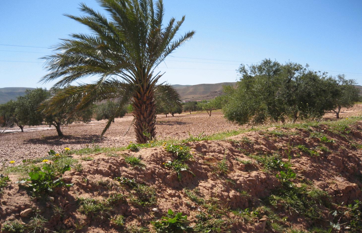
The tabia earthen dyke is a water harvesting technique used in the foothill and piedmont areas.
2.2 Detailed description of the Technology
Description:
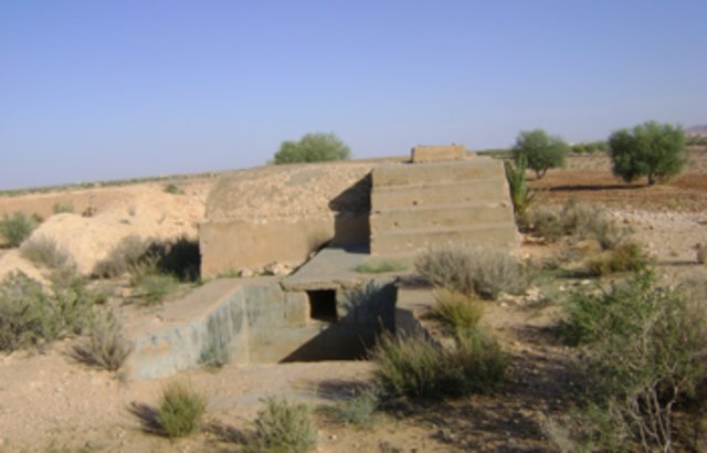
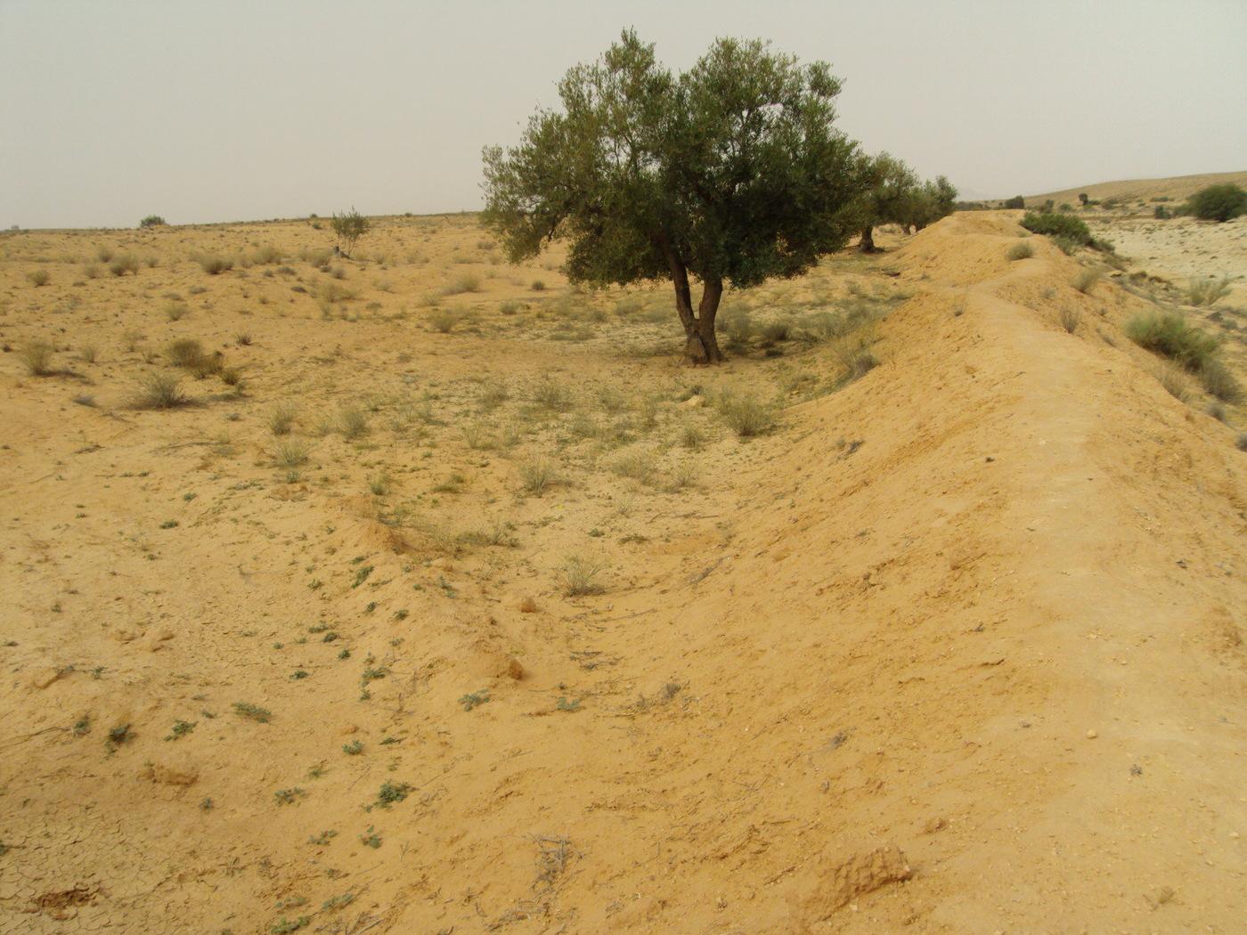
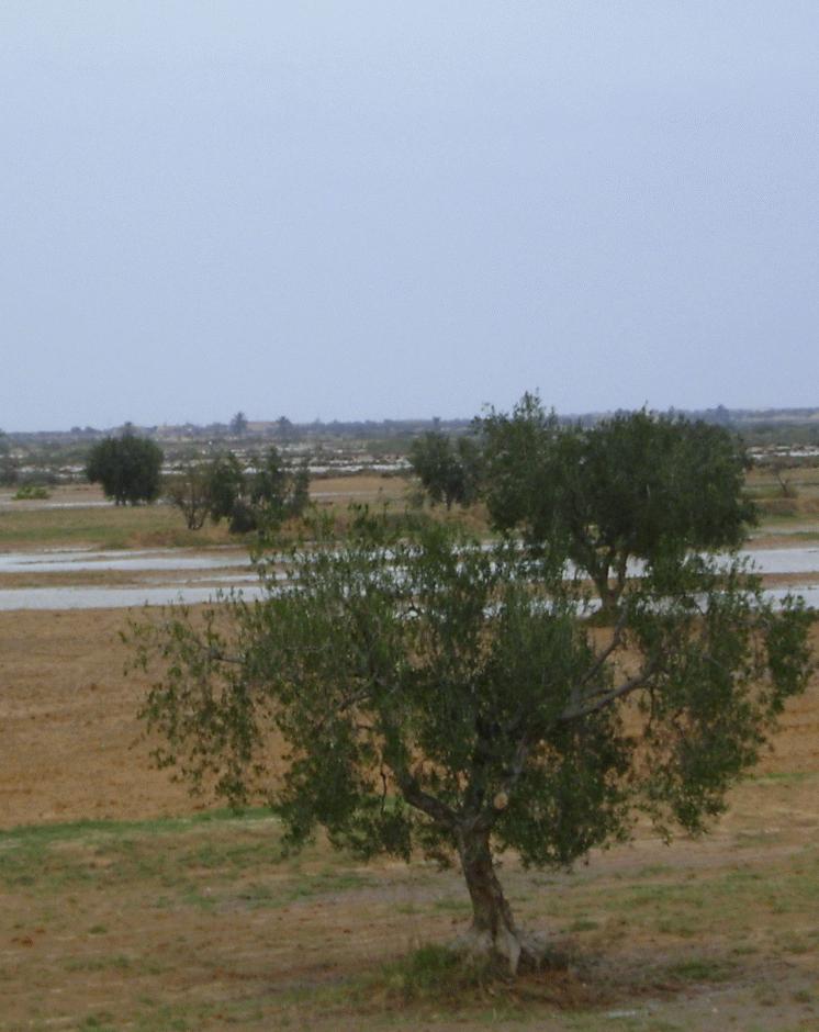
The tabia technology is similar to the jessour system but is used in the gently-sloping foothill and piedmont areas. It is considered to be a relatively new technique, developed by mountain dwellers who migrated to the plains. Tabias, like jessour, comprise an earthen dyke (50-150 m in length, 1-2 m in height), a spillway (central and/or lateral) and an associated water harvesting area. The ratio between the area where water is applied (cropped area) and the total area from which water is collected varies from 1:6 to 1:20. The differences between the tabia and the jessour systems are that the former contains two additional lateral bunds (up to 30 m long) and sometimes a small flood diversion dyke (mgoud). Small tabia are constructed manually using shovels, pickles and carts. Larger constructions are done mechanically using tractors and bulldozers.
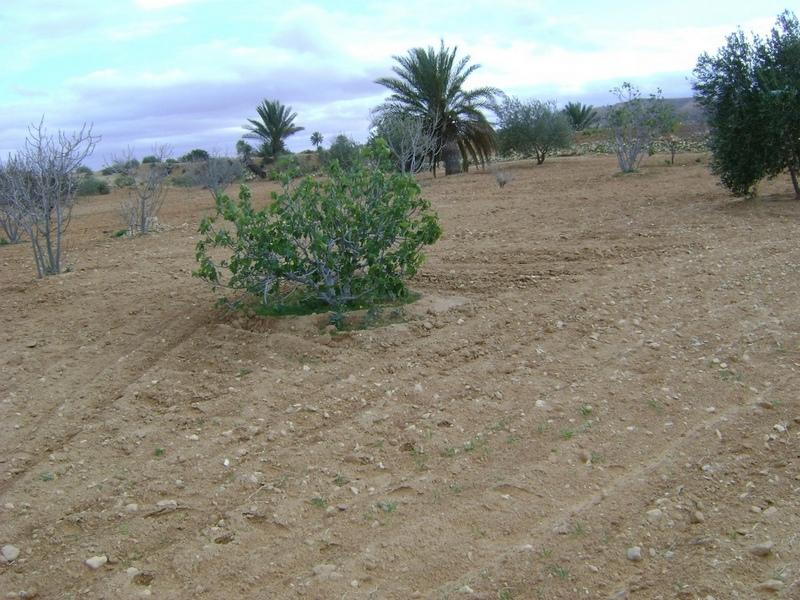
Purpose of the Technology: Tree products and annual crops are commonly grown using tabia. Besides their water harvesting qualities, tabias also have a positive effect on soil erosion and groundwater recharge.
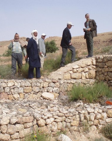
Natural / human environment: The tabia runoff-water harvesting technique is widely practised in central Tunisia. Tabias are usually installed on the piedmont, where the slope does not exceed 3% and where the soil is relatively deep. Ancient remnants of tabias have been found in the region of Gafsa (south west Tunisia). The system has been adopted by people living in the neighbouring foothills and plains of the central and southeastern regions (Jeffara) of the country, following the transformation of their pasture to cultivated fields.
2.3 Photos of the Technology
Media Gallery
2.5 Country/ region/ locations where the Technology has been applied and which are covered by this assessment
Country:
Tunisia
Region/ State/ Province:
Medenine
Further specification of location:
Medenine nord
Specify the spread of the Technology:
- evenly spread over an area
If precise area is not known, indicate approximate area covered:
- 10-100 km2
Map
×2.6 Date of implementation
If precise year is not known, indicate approximate date:
- 10-50 years ago
2.7 Introduction of the Technology
Specify how the Technology was introduced:
- through projects/ external interventions
3. Classification of the SLM Technology
3.2 Current land use type(s) where the Technology is applied

Cropland
- Tree and shrub cropping
Number of growing seasons per year:
- 1
Specify:
Période de croissance la plus longue en jour: 180,Période de croissance la plus longue d'un mois à l'autre: Octobre - Avril

Grazing land
Comments:
Problèmes principaux d'utilisation des terres (avis du compilateur): érosion hydrique des sols, ruissellement et perte de terre, surpâturage
Major land use problems (land users’ perception): overgrazing
3.4 Water supply
Water supply for the land on which the Technology is applied:
- mixed rainfed-irrigated
3.5 SLM group to which the Technology belongs
- water harvesting
3.6 SLM measures comprising the Technology

structural measures
- S2: Bunds, banks
Comments:
Main measures: structural measures
3.7 Main types of land degradation addressed by the Technology

soil erosion by water
- Wt: loss of topsoil/ surface erosion
- Wg: gully erosion/ gullying
Comments:
Main type of degradation addressed: Wt: loss of topsoil / surface erosion
Secondary types of degradation addressed: Wg: gully erosion / gullying
Main causes of degradation: Heavy / extreme rainfall (intensity/amounts), land tenure
Secondary causes of degradation: overgrazing, population pressure
3.8 Prevention, reduction, or restoration of land degradation
Specify the goal of the Technology with regard to land degradation:
- prevent land degradation
- reduce land degradation
Comments:
Main goals: prevention of land degradation
Secondary goals: mitigation / reduction of land degradation
4. Technical specifications, implementation activities, inputs, and costs
4.1 Technical drawing of the Technology
Technical specifications (related to technical drawing):
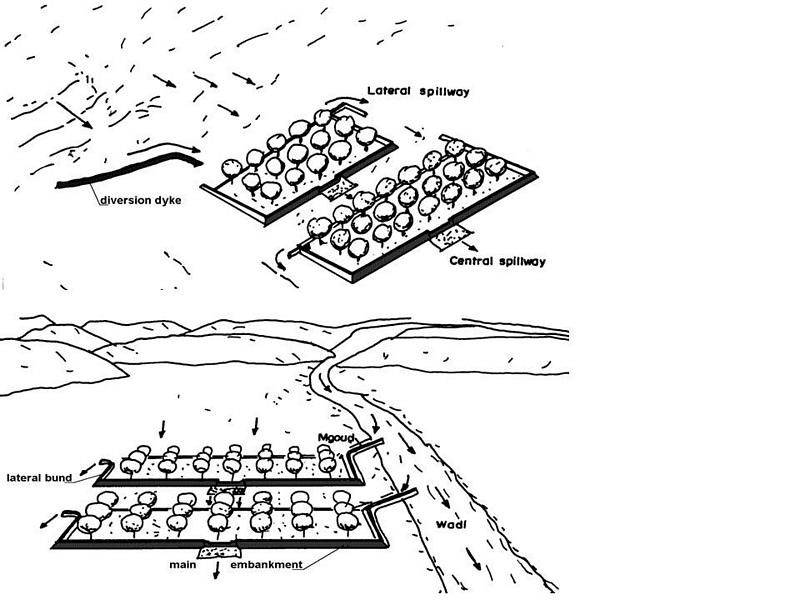
Tabia avec zone de collecte d'eau naturelle (supérieure) et tabia sur un système agrandi avec dérivation d'eau supplémentaire (inférieure). (Adapté d'Alaya et al., 1993)
Trouvé dans les zones plus plates, tabia peut accueillir plus d'arbres sur la terrasse en particulier quand il peut recevoir d'eau supplémentaire des inondations.
Localisation: Tunisie sud-est
Date: Janvier 2009
Connaissances techniques requises pour le personnel sur le terrain / conseillers: moyen
Connaissances techniques requises pour les utilisateurs des terres: moyen
Fonctions principales techniques: contrôle du ruissellement en ravines: rétention/capture
Fonctions techniques secondaire: augmentation de l'infiltration, récupération de l’eau / augmentation des réserves d’eau, épandage des eaux
Détournement de dérivation / drainage
Hauteur des bunds/barrages/autres (m): 2
Largeur des bunds/barrages/autres (m): 2-5
Longueur des bunds/barrages/autres (m): 10-30
Déversoir
Hauteur des bunds/barrages/autres (m): 1
Largeur des bunds/barrages/autres (m): 5
Length of bunds/banks/others (m): 2-4
Mur de protection/ rive: rectifié
Intervalle verticales entres les structures (m): 3
Espacement entre les structures (m): 100
Hauteur des bunds/barragues/autres (m): 2
Largeur des bunds/barrages/autres (m): 2-5
Longueur des bunds/barrages/autres (m): 50-150
Materiel de construction (terre): Digue principale
Materiel de construction (Pierres): Déversoir
Materiel de construction (béton): Déversoir
Materiel de construction (autres): Gabion: digue de dérivation
Gradient latéral le long de la structure: 1%
Pour la récolte de l'eau: Ratio entre la zone où l'eau récoltée est appliquée et la superficie totale d'où provient l'eau est 1:4
Author:
Adapted from Alaya et al. 1993
4.2 General information regarding the calculation of inputs and costs
other/ national currency (specify):
TND
If relevant, indicate exchange rate from USD to local currency (e.g. 1 USD = 79.9 Brazilian Real): 1 USD =:
1.3
Indicate average wage cost of hired labour per day:
10.00
4.3 Establishment activities
| Activity | Timing (season) | |
|---|---|---|
| 1. | Diversion channel | in the case of tabia on spreading system |
| 2. | Plantation | |
| 3. | Spillway construction | |
| 4. | Terracing |
4.4 Costs and inputs needed for establishment
| Specify input | Unit | Quantity | Costs per Unit | Total costs per input | % of costs borne by land users | |
|---|---|---|---|---|---|---|
| Labour | Labour | ha | 1.0 | 500.0 | 500.0 | 100.0 |
| Construction material | ha | 1.0 | 170.0 | 170.0 | 100.0 | |
| Total costs for establishment of the Technology | 670.0 | |||||
| Total costs for establishment of the Technology in USD | 515.38 | |||||
Comments:
Duration of establishment phase: 1 month(s)
4.5 Maintenance/ recurrent activities
| Activity | Timing/ frequency | |
|---|---|---|
| 1. | Dyke and spillway maintenance | Annually |
| 2. | Reconstruction |
4.6 Costs and inputs needed for maintenance/ recurrent activities (per year)
| Specify input | Unit | Quantity | Costs per Unit | Total costs per input | % of costs borne by land users | |
|---|---|---|---|---|---|---|
| Labour | Labour | ha | 1.0 | 150.0 | 150.0 | 100.0 |
| Construction material | ha | 1.0 | 50.0 | 50.0 | 100.0 | |
| Total costs for maintenance of the Technology | 200.0 | |||||
| Total costs for maintenance of the Technology in USD | 153.85 | |||||
Comments:
The technology establishment and maintenance costs met by the land users are 100% if executed on a private basis, but it can range from 10 to 50% when the site is part of a publicly-funded programme.
4.7 Most important factors affecting the costs
Describe the most determinate factors affecting the costs:
Labour is the most determining factor affecting the costs.
5. Natural and human environment
5.1 Climate
Annual rainfall
- < 250 mm
- 251-500 mm
- 501-750 mm
- 751-1,000 mm
- 1,001-1,500 mm
- 1,501-2,000 mm
- 2,001-3,000 mm
- 3,001-4,000 mm
- > 4,000 mm
Agro-climatic zone
- arid
Thermal climate class: subtropics
5.2 Topography
Slopes on average:
- flat (0-2%)
- gentle (3-5%)
- moderate (6-10%)
- rolling (11-15%)
- hilly (16-30%)
- steep (31-60%)
- very steep (>60%)
Landforms:
- plateau/plains
- ridges
- mountain slopes
- hill slopes
- footslopes
- valley floors
Altitudinal zone:
- 0-100 m a.s.l.
- 101-500 m a.s.l.
- 501-1,000 m a.s.l.
- 1,001-1,500 m a.s.l.
- 1,501-2,000 m a.s.l.
- 2,001-2,500 m a.s.l.
- 2,501-3,000 m a.s.l.
- 3,001-4,000 m a.s.l.
- > 4,000 m a.s.l.
5.3 Soils
Soil depth on average:
- very shallow (0-20 cm)
- shallow (21-50 cm)
- moderately deep (51-80 cm)
- deep (81-120 cm)
- very deep (> 120 cm)
Soil texture (topsoil):
- medium (loamy, silty)
Topsoil organic matter:
- low (<1%)
If available, attach full soil description or specify the available information, e.g. soil type, soil PH/ acidity, Cation Exchange Capacity, nitrogen, salinity etc.
Soil fertility is: very low
Soil drainage/infiltration is: medium
Soil water storage is: medium
5.4 Water availability and quality
Ground water table:
5-50 m
Availability of surface water:
medium
Water quality (untreated):
poor drinking water (treatment required)
Comments and further specifications on water quality and quantity:
Water quality (untreated): Poor drinking water (treatement required/medium quality)
5.5 Biodiversity
Species diversity:
- medium
5.6 Characteristics of land users applying the Technology
Market orientation of production system:
- mixed (subsistence/ commercial)
Off-farm income:
- > 50% of all income
Relative level of wealth:
- poor
- average
Individuals or groups:
- individual/ household
Gender:
- men
Indicate other relevant characteristics of the land users:
Land users applying the Technology are mainly common / average land users
Difference in the involvement of women and men: Outdoor hard works are generally performed by men.
Population density: 10-50 persons/km2
Annual population growth: 0.5% - 1%
10% of the land users are rich and own 10% of the land.
70% of the land users are average wealthy and own 75% of the land.
20% of the land users are poor and own 15% of the land.
5.7 Average area of land used by land users applying the Technology
- < 0.5 ha
- 0.5-1 ha
- 1-2 ha
- 2-5 ha
- 5-15 ha
- 15-50 ha
- 50-100 ha
- 100-500 ha
- 500-1,000 ha
- 1,000-10,000 ha
- > 10,000 ha
Is this considered small-, medium- or large-scale (referring to local context)?
- small-scale
5.8 Land ownership, land use rights, and water use rights
Land ownership:
- individual, not titled
- individual, titled
Land use rights:
- individual
Water use rights:
- individual
5.9 Access to services and infrastructure
health:
- poor
- moderate
- good
education:
- poor
- moderate
- good
technical assistance:
- poor
- moderate
- good
employment (e.g. off-farm):
- poor
- moderate
- good
markets:
- poor
- moderate
- good
energy:
- poor
- moderate
- good
roads and transport:
- poor
- moderate
- good
drinking water and sanitation:
- poor
- moderate
- good
financial services:
- poor
- moderate
- good
6. Impacts and concluding statements
6.1 On-site impacts the Technology has shown
Socio-economic impacts
Production
crop production
risk of production failure
Income and costs
farm income
Other socio-economic impacts
Grazing land
Socio-cultural impacts
food security/ self-sufficiency
SLM/ land degradation knowledge
conflict mitigation
Improved livelihoods and human well-being
Ecological impacts
Water cycle/ runoff
harvesting/ collection of water
surface runoff
groundwater table/ aquifer
evaporation
Soil
soil loss
6.2 Off-site impacts the Technology has shown
water availability
reliable and stable stream flows in dry season
downstream flooding
downstream siltation
damage on public/ private infrastructure
6.3 Exposure and sensitivity of the Technology to gradual climate change and climate-related extremes/ disasters (as perceived by land users)
Gradual climate change
Gradual climate change
| Season | increase or decrease | How does the Technology cope with it? | |
|---|---|---|---|
| annual temperature | increase | well |
Climate-related extremes (disasters)
Meteorological disasters
| How does the Technology cope with it? | |
|---|---|
| local rainstorm | well |
| local windstorm | well |
Climatological disasters
| How does the Technology cope with it? | |
|---|---|
| drought | not well |
Hydrological disasters
| How does the Technology cope with it? | |
|---|---|
| general (river) flood | not well |
Other climate-related consequences
Other climate-related consequences
| How does the Technology cope with it? | |
|---|---|
| reduced growing period | well |
6.4 Cost-benefit analysis
How do the benefits compare with the establishment costs (from land users’ perspective)?
Short-term returns:
negative
Long-term returns:
very positive
How do the benefits compare with the maintenance/ recurrent costs (from land users' perspective)?
Short-term returns:
positive
Long-term returns:
very positive
6.5 Adoption of the Technology
Of all those who have adopted the Technology, how many did so spontaneously, i.e. without receiving any material incentives/ payments?
- 51-90%
Comments:
35% of land user families have adopted the Technology with external material support
65% of land user families have adopted the Technology without any external material support
There is a strong trend towards spontaneous adoption of the Technology
6.7 Strengths/ advantages/ opportunities of the Technology
| Strengths/ advantages/ opportunities in the land user’s view |
|---|
| Improved production and expansion of cropping land. |
| Strengths/ advantages/ opportunities in the compiler’s or other key resource person’s view |
|---|
|
This technique allows a rapid expansion of cropping lands in the piedmont and flat areas How can they be sustained / enhanced? encourage maintenance of existing structure. |
|
Allows crop production in very dry environments (with less than 200 mm of rainfall) How can they be sustained / enhanced? encourage maintenance of existing structure. |
|
Collects and accumulates water, soil and nutrients behind the tabia and makes it available to crops How can they be sustained / enhanced? encourage maintenance of existing structure. |
|
Reduced damage by flooding How can they be sustained / enhanced? encourage maintenance of existing structure. |
6.8 Weaknesses/ disadvantages/ risks of the Technology and ways of overcoming them
| Weaknesses/ disadvantages/ risks in the land user’s view | How can they be overcome? |
|---|---|
| Expansion is done at the expense of natural grazing land. |
| Weaknesses/ disadvantages/ risks in the compiler’s or other key resource person’s view | How can they be overcome? |
|---|---|
| Risks related to the climatic changes | it needs to be combined with supplementary irrigation. |
| Drought spells | Supplemental irrigation. |
| Land ownership fragmentation | new land access / agrarian reform. |
| Productivity of the land is very low | development of alternative income generation activities. |
| Risk of local know-how disappearance | training of new generations. |
7. References and links
7.1 Methods/ sources of information
7.2 References to available publications
Title, author, year, ISBN:
Alaya, K., Viertmann, W., Waibel, Th. 1993. Les tabias. Imprimerie Arabe de Tunisie, Tunis, Tunisia. 192 pp.
Available from where? Costs?
IRA
Title, author, year, ISBN:
Ben Mechlia, N., Ouessar, M. 2004. Water harvesting systems in Tunisia. In: Oweis, T., Hachum, A., Bruggeman, A. (eds). Indigenous water harvesting in West Asia and North Africa, , ICARDA, Aleppo, Syria, pp: 21-41
Available from where? Costs?
IRA, ICARDA
Title, author, year, ISBN:
Ennabli, N. 1993. Les aménagements hydrauliques et hydro-agricoles en Tunisie. Imprimerie Officielle de la République Tunisienne, Tunis, 255 pp.
Available from where? Costs?
IRA, INAT
Title, author, year, ISBN:
Genin, D., Guillaume, H., Ouessar, M., Ouled Belgacem, A., Romagny, B., Sghaier, M., Taamallah, H. (eds) 2006. Entre la désertification et le développement : la Jeffara tunisienne. CERES, Tunis, 351 pp.
Available from where? Costs?
IRA, IRD
Title, author, year, ISBN:
Nasri, S. 2002. Hydrological effects of water harvesting techniques. Ph.D. thesis, Lund University, Sweden, 104 pp.
Available from where? Costs?
IRA, INRGREF
Title, author, year, ISBN:
Sghaier, M., Mahdhi, N., De Graaff, J., Ouessar, M. 2002. Economic assessment of soil and water conservation works: case of the wadi Oum Zessar watershed in south-eastern Tunisia.TRMP paper n° 40, Wageningen University, The Netherlands, pp: 101-113.
Available from where? Costs?
IRA
Title, author, year, ISBN:
Ouessar M. 2007. Hydrological impacts of rainwater harvesting in wadi Oum Zessar watershed (Southern Tunisia). Ph.D. thesis, Faculty of Bioscience Engineering, Ghent University, Ghent, Belgium, 154 pp.
Available from where? Costs?
IRA
Links and modules
Expand all Collapse allLinks
Territorial Natural Resource Management Observatory [Tunisia]
A territorial natural resources management observatory is a scientific, technical and institutional system set up in a given area to observe, monitor and improve knowledge.
- Compiler: Wafa Saidi
Integrated Territorial Planning and Development Project (PADIT) [Tunisia]
The PADIT approach comprises a cross-cutting participatory methodology to rural development, rallying various stakeholders around a project, within a location, to identify the main economic areas of the rural community concerned, and draw up a prioritized list of actions to strengthen and support development efforts in their location.
- Compiler: Wafa Saidi
Collecte des eaux pluviales dans des citernes [Tunisia]
Les citernes sont construites soit par l’état dans les zones enclavées où l’approvisionnement en eaux potables et difficile voire impossible par le réseau de la Société Nationale d’Exploitation et de Distribution des Eaux (SONEDE) soit par des particuliers pour collecter les eaux de pluies. Ces ouvrages sont destinés à l’abreuvement …
- Compiler: Donia Mühlematter
Conservation des eaux et des sols suivant la … [Tunisia]
Les tabias sont développés dans les piedmonts des Djebels et les plaines à pente légère (n’excédant pas les 3 %) du centre et du sud tunisien où la pluviométrie annuelle est relativement faible. Les zones aménagées en tabias reçoivent annuellement un supplément d’eau de ruissellement permettant une agriculture pluviale très …
- Compiler: Donia Mühlematter
Dryland watershed management approach [Tunisia]
Integrated land and water management approach, including vegetative, management, and agronomic measure
- Compiler: Naceur Mahdi
Modules
No modules