Controlling of soil erosion during crop production [South Africa]
- Creation:
- Update:
- Compiler: Carin Pretorius
- Editor: –
- Reviewer: Alexandra Gavilano
technologies_950 - South Africa
View sections
Expand all Collapse all1. General information
1.3 Conditions regarding the use of data documented through WOCAT
When were the data compiled (in the field)?
15/04/2004
The compiler and key resource person(s) accept the conditions regarding the use of data documented through WOCAT:
Yes
2. Description of the SLM Technology
2.1 Short description of the Technology
Definition of the Technology:
The technology that applies contouring, mulching and intercropping in SWC.
2.2 Detailed description of the Technology
Description:
Agronomic technology is used to control soil erosion during the crop production period, i.e. method that is employed to improve soil fertility, conserve water and protect from soil erosion while the land is under crop production.
Purpose of the Technology: The purpose is to keep the fertility of the soil stable by protecting the soil from soil erosion and water loss.
Establishment / maintenance activities and inputs: The establishment is either done by planting strong root crops in between cultivated areas, or leaving the soil uncultivated, with a mulch cover on the soil surface. This will be maintained by keeping the intercrop strong and healthy while using zero or minimum tillage without removal of left over material on the soil surface.
2.3 Photos of the Technology
Media Gallery
2.5 Country/ region/ locations where the Technology has been applied and which are covered by this assessment
Country:
South Africa
Region/ State/ Province:
Limpopo Province
Further specification of location:
Sekhukuneland
2.6 Date of implementation
If precise year is not known, indicate approximate date:
- less than 10 years ago (recently)
2.7 Introduction of the Technology
Specify how the Technology was introduced:
- through projects/ external interventions
Comments (type of project, etc.):
Western World
3. Classification of the SLM Technology
3.2 Current land use type(s) where the Technology is applied

Cropland
- Annual cropping
Comments:
Major land use problems (compiler’s opinion): Silting and low infiltration rate.
Major land use problems (land users’ perception): Injudicious cultivation.
Other grazingland: intensive grazing land
Grazingland comments: Cattle graze in the cropland during winter periods.
Type of cropping system and major crops comments: Maize mixed with groundnuts.
Maize mixed with dry beans
Type of grazing system comments: Cattle graze in the cropland during winter periods.
3.3 Further information about land use
Comments:
Water supply: mixed rainfed - irrigated, rainfed
Number of growing seasons per year:
- 1
Specify:
Longest growing period in days: 120
Longest growing period from month to month: Nov - Feb
3.5 Spread of the Technology
Specify the spread of the Technology:
- evenly spread over an area
If the Technology is evenly spread over an area, indicate approximate area covered:
- 1-10 km2
Comments:
Total area covered by the SLM Technology is 10 m2.
Soil conservation measures were constructed (contour banks), then but was looked after until 1980's.
3.6 SLM measures comprising the Technology
3.7 Main types of land degradation addressed by the Technology

soil erosion by water
- Wt: loss of topsoil/ surface erosion
Comments:
Main type of degradation addressed: Wt: loss of topsoil / surface erosion
Main causes of degradation: other human induced causes (specify) (Agricultural causes)
Secondary causes of degradation: other natural causes (avalanches, volcanic eruptions, mud flows, highly susceptible natural resources, extreme topography, etc.) specify
3.8 Prevention, reduction, or restoration of land degradation
Specify the goal of the Technology with regard to land degradation:
- prevent land degradation
Comments:
Main goals: prevention of land degradation
4. Technical specifications, implementation activities, inputs, and costs
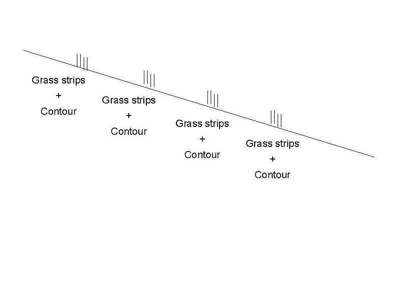
4.1 Technical drawing of the Technology
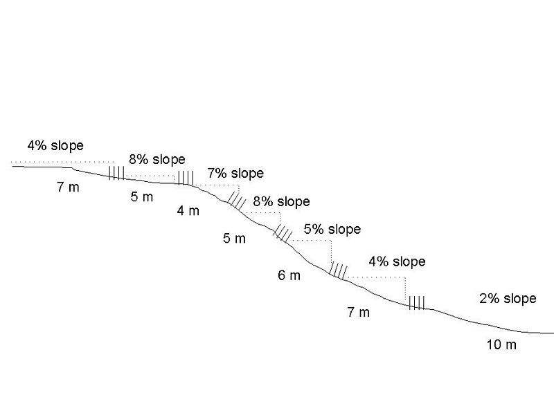
Author:
Mokgwakgwe Mashatola
4.2 Technical specifications/ explanations of technical drawing
Technical drawing off slope
Location: Mahlanga. Northern Province
Technical knowledge required for field staff / advisors: moderate
Technical knowledge required for land users: moderate
Main technical functions: control of concentrated runoff: retain / trap, control of concentrated runoff: drain / divert
4.3 General information regarding the calculation of inputs and costs
other/ national currency (specify):
Rand
Indicate exchange rate from USD to local currency (if relevant): 1 USD =:
10.00
Indicate average wage cost of hired labour per day:
6.00
4.5 Costs and inputs needed for establishment
Comments:
Duration of establishment phase: 24 month(s)
4.6 Maintenance/ recurrent activities
| Activity | Type of measure | Timing/ frequency | |
|---|---|---|---|
| 1. | Conventional tillage | Agronomic | early in rainy season / once a year |
4.7 Costs and inputs needed for maintenance/ recurrent activities (per year)
Comments:
Machinery/ tools: tractor/gallion
Grass strips per ha.
4.8 Most important factors affecting the costs
Describe the most determinate factors affecting the costs:
The voluntary labour was at minimal, therefore labour affected the cost significantly.
5. Natural and human environment
5.1 Climate
Annual rainfall
- < 250 mm
- 251-500 mm
- 501-750 mm
- 751-1,000 mm
- 1,001-1,500 mm
- 1,501-2,000 mm
- 2,001-3,000 mm
- 3,001-4,000 mm
- > 4,000 mm
Agro-climatic zone
- semi-arid
5.2 Topography
Slopes on average:
- flat (0-2%)
- gentle (3-5%)
- moderate (6-10%)
- rolling (11-15%)
- hilly (16-30%)
- steep (31-60%)
- very steep (>60%)
Landforms:
- plateau/plains
- ridges
- mountain slopes
- hill slopes
- footslopes
- valley floors
Altitudinal zone:
- 0-100 m a.s.l.
- 101-500 m a.s.l.
- 501-1,000 m a.s.l.
- 1,001-1,500 m a.s.l.
- 1,501-2,000 m a.s.l.
- 2,001-2,500 m a.s.l.
- 2,501-3,000 m a.s.l.
- 3,001-4,000 m a.s.l.
- > 4,000 m a.s.l.
5.3 Soils
Soil depth on average:
- very shallow (0-20 cm)
- shallow (21-50 cm)
- moderately deep (51-80 cm)
- deep (81-120 cm)
- very deep (> 120 cm)
Soil texture (topsoil):
- coarse/ light (sandy)
Topsoil organic matter:
- low (<1%)
5.6 Characteristics of land users applying the Technology
Market orientation of production system:
- subsistence (self-supply)
Off-farm income:
- less than 10% of all income
Relative level of wealth:
- poor
- very poor
Level of mechanization:
- mechanized/ motorized
Indicate other relevant characteristics of the land users:
Population density: > 500 persons/km2
1% of the land users are average wealthy.
66% of the land users are poor.
33% of the land users are poor.
5.7 Average area of land owned or leased by land users applying the Technology
- < 0.5 ha
- 0.5-1 ha
- 1-2 ha
- 2-5 ha
- 5-15 ha
- 15-50 ha
- 50-100 ha
- 100-500 ha
- 500-1,000 ha
- 1,000-10,000 ha
- > 10,000 ha
6. Impacts and concluding statements
6.1 On-site impacts the Technology has shown
Socio-economic impacts
Production
crop production
production area
land management
Socio-cultural impacts
community institutions
Ecological impacts
Water cycle/ runoff
surface runoff
Quantity before SLM:
40
Quantity after SLM:
10
Soil
soil moisture
soil cover
soil loss
Quantity before SLM:
0.5
Quantity after SLM:
0
6.2 Off-site impacts the Technology has shown
reliable and stable stream flows in dry season
downstream flooding
6.4 Cost-benefit analysis
How do the benefits compare with the establishment costs (from land users’ perspective)?
Short-term returns:
slightly positive
Long-term returns:
positive
How do the benefits compare with the maintenance/ recurrent costs (from land users' perspective)?
Short-term returns:
slightly negative
Long-term returns:
slightly positive
6.5 Adoption of the Technology
Comments:
97% of land user families have adopted the Technology with external material support
350 land user families have adopted the Technology with external material support
Comments on acceptance with external material support: estimates
6.7 Strengths/ advantages/ opportunities of the Technology
| Strengths/ advantages/ opportunities in the land user’s view |
|---|
|
Soil protection How can they be sustained / enhanced? Involve land-users right from the beginning and allow them to run the SWC on their own |
| Strengths/ advantages/ opportunities in the compiler’s or other key resource person’s view |
|---|
|
Control soil erosion effectively How can they be sustained / enhanced? Involve land-users right from the beginning and allow them to run the SWC on their own |
| Conserve moisture |
6.8 Weaknesses/ disadvantages/ risks of the Technology and ways of overcoming them
| Weaknesses/ disadvantages/ risks in the compiler’s or other key resource person’s view | How can they be overcome? |
|---|---|
| Implementation | Implement with the land users and allow the land users to own the technology |
7. References and links
7.2 References to available publications
Title, author, year, ISBN:
Sustainable land use plan for Nebo-district
Available from where? Costs?
Department of Soil Science, University of the North
Links and modules
Expand all Collapse allLinks
No links
Modules
No modules