Improved Well Distribution for Sustainable Pastoralism [Niger]
- Creation:
- Update:
- Compiler: Soumaila Abdoulaye
- Editor: –
- Reviewers: David Streiff, Alexandra Gavilano
technologies_1355 - Niger
View sections
Expand all Collapse all1. General information
1.2 Contact details of resource persons and institutions involved in the assessment and documentation of the Technology
Name of the institution(s) which facilitated the documentation/ evaluation of the Technology (if relevant)
GREAD (GREAD) - Niger1.3 Conditions regarding the use of data documented through WOCAT
The compiler and key resource person(s) accept the conditions regarding the use of data documented through WOCAT:
Yes
2. Description of the SLM Technology
2.1 Short description of the Technology
Definition of the Technology:
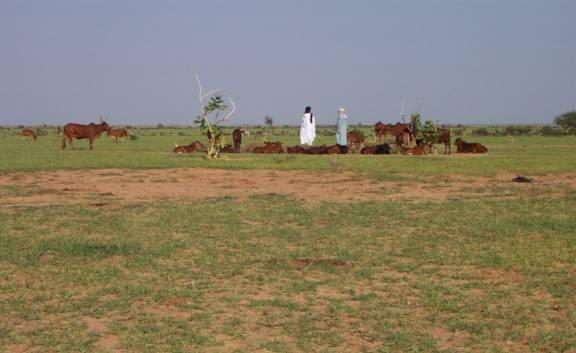
Pastoralism, as practiced in the case study area, is the traditional mode of extensive livestock husbandry, based on the movement of herds between the rich pastures in the northern pastoral zones (rainy season) and the southern areas (dry season) according to seasonal availability of water and grazing land / fodder (including residual vegetation of cropland).
2.2 Detailed description of the Technology
Description:
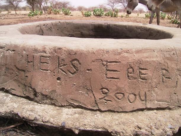
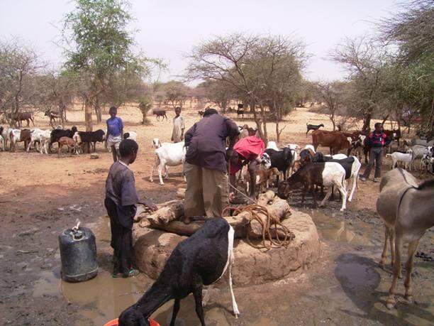
Both forms of pastoralism – nomadism and transhumance – are facing increasing water and fodder availability problems, due to a variety of reasons: change of climatic conditions, expansion of cropland, overstocking and overgrazing, amongst others. In view of these problems, the govern¬ment of Niger has defined by law a pastoral zone, where crop production is limited to subsistence. Within this area ‘Pastoral Modernization Zones’ have been implemented, based on a new concept of semi-pastoralism to assure the sustainability of the pastoral land use system. Several practices are promoted at field level: improved distribution of water points, establishment of water harvesting structures, improved passage ways for herds, improved fodder production, etc. An optimal and efficient network / distribution of water points is a key element of modern sustainable pastoralism: it assures a balanced distribution of herds, and thus avoids overuse of vegetation around a limited number of wells. Since 1998, the number of traditional wells within the 3,000 km2 of Akoubounou pastoral area has increased from 7 to 58: Construction is done by the local community – through trained well diggers. Support is provided by different development actors (government and NGOs). Well committees on community level are responsible for proper management of the wells. A fund for maintenance is established and is topped up through contributions of well users. As a result of the improved well distribution, pastoral areas have been utilised in a more balanced manner, and overgrazing problems have been reduced by 30-40% compared to the situation in 1990.
2.3 Photos of the Technology
Media Gallery
2.5 Country/ region/ locations where the Technology has been applied and which are covered by this assessment
Country:
Niger
Region/ State/ Province:
Tahoua region
Further specification of location:
Akouboubou, Abalak
Specify the spread of the Technology:
- applied at specific points/ concentrated on a small area
Comments:
Total area covered by the SLM Technology is 3000 km2.
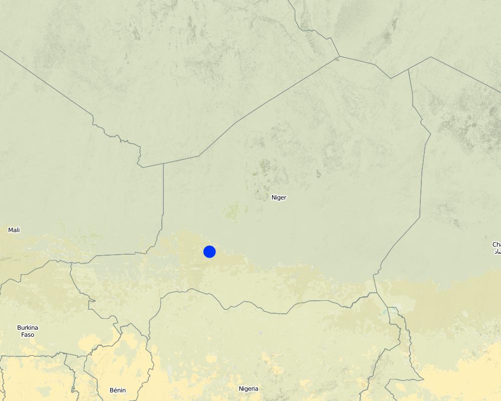
Map
×2.7 Introduction of the Technology
Specify how the Technology was introduced:
- through projects/ external interventions
3. Classification of the SLM Technology
3.1 Main purpose(s) of the Technology
- reduce, prevent, restore land degradation
- adapt to climate change/ extremes and its impacts
3.2 Current land use type(s) where the Technology is applied

Cropland
- Annual cropping

Grazing land
Extensive grazing:
- Semi-nomadic pastoralism
Comments:
Major land use problems (land users’ perception): Soil erosion by water, soil erosion by wind; biological degradation (overgrazing), change of climatic conditions, expansion of cropland, overstocking and overgrazing
3.4 Water supply
Water supply for the land on which the Technology is applied:
- rainfed
3.5 SLM group to which the Technology belongs
- pastoralism and grazing land management
- irrigation management (incl. water supply, drainage)
3.6 SLM measures comprising the Technology

management measures
- M3: Layout according to natural and human environment
3.7 Main types of land degradation addressed by the Technology

soil erosion by water
- Wt: loss of topsoil/ surface erosion

soil erosion by wind
- Et: loss of topsoil

physical soil deterioration
- Pc: compaction

biological degradation
- Bc: reduction of vegetation cover
3.8 Prevention, reduction, or restoration of land degradation
Specify the goal of the Technology with regard to land degradation:
- reduce land degradation
- restore/ rehabilitate severely degraded land
4. Technical specifications, implementation activities, inputs, and costs
4.1 Technical drawing of the Technology
Technical specifications (related to technical drawing):
Technical knowledge required for field staff / advisors: moderate
Technical knowledge required for land users: low
Main technical functions: improvement of ground cover, improvement of topsoil structure (compaction), increase of biomass (quantity)
Layout change according to natural and human environment: efficient network / distribution of water points
4.2 General information regarding the calculation of inputs and costs
Specify currency used for cost calculations:
- USD
4.3 Establishment activities
| Activity | Timing (season) | |
|---|---|---|
| 1. | Information and awareness raising campaign in village. Participatory planning (1-2 days) / Identification of sites by population, accompanied by field technicians | |
| 2. | Formation and training of members of well management committee: laws, responsi¬bilities, steering, evaluation, organization, etc. (3-4 days) / Training of traditional sinkers (by external experts 1998-2000, then farmer-to-farmer training) | |
| 3. | Dig well shaft: 0.8-1.5 m in diameter and 20-60 m deep (using pickaxe, shovel, bucket) | |
| 4. | Installer un dispositif de mesure (en cuir de vache ou pneu ; fils et piquets) / Facultatif : tapisser le conduit du puits avec des pierres / ciment (p. ex. si le sol n'est pas assez compact) | |
| 5. | Construire un mur de protection en pierres et ciment autour du puits (0,2-0,3 m de large et 0,5-1 m de haut) |
4.4 Costs and inputs needed for establishment
| Specify input | Unit | Quantity | Costs per Unit | Total costs per input | % of costs borne by land users | |
|---|---|---|---|---|---|---|
| Labour | Information and awareness raising campaign in village. Participatory planning | campaign | 1.0 | 800.0 | 800.0 | 9.0 |
| Labour | Construction of well (labour, equipment, material) | well | 1.0 | 1200.0 | 1200.0 | 9.0 |
| Total costs for establishment of the Technology | 2000.0 | |||||
| Total costs for establishment of the Technology in USD | 2000.0 | |||||
4.5 Maintenance/ recurrent activities
| Activity | Timing/ frequency | |
|---|---|---|
| 1. | De-silting of wells | Beginning of rainy season; May-June |
| 2. | De-silting of wells | End of rainy season, Oct.-Nov |
| 3. | Reinforce walls of wells with cement | End of rainy season, Oct.-Nov |
| 4. | Deepen the well in case of descending groundwater level |
4.6 Costs and inputs needed for maintenance/ recurrent activities (per year)
| Specify input | Unit | Quantity | Costs per Unit | Total costs per input | % of costs borne by land users | |
|---|---|---|---|---|---|---|
| Labour | De-silting of wells | wells | 1.0 | 280.0 | 280.0 | 100.0 |
| Total costs for maintenance of the Technology | 280.0 | |||||
| Total costs for maintenance of the Technology in USD | 280.0 | |||||
4.7 Most important factors affecting the costs
Describe the most determinate factors affecting the costs:
A management fund is established and managed by each well committee. Well users contribute annually, or each time maintenance work is needed. Amounts of contribution are not fixed, but up to the individual and generally proportionate to herd size. Committee can fine land users who damage the wells.
5. Natural and human environment
5.1 Climate
Annual rainfall
- < 250 mm
- 251-500 mm
- 501-750 mm
- 751-1,000 mm
- 1,001-1,500 mm
- 1,501-2,000 mm
- 2,001-3,000 mm
- 3,001-4,000 mm
- > 4,000 mm
Specify average annual rainfall (if known), in mm:
300.00
Specifications/ comments on rainfall:
Rainy season May-October
Agro-climatic zone
- semi-arid
Thermal climate class: tropics
5.2 Topography
Slopes on average:
- flat (0-2%)
- gentle (3-5%)
- moderate (6-10%)
- rolling (11-15%)
- hilly (16-30%)
- steep (31-60%)
- very steep (>60%)
Landforms:
- plateau/plains
- ridges
- mountain slopes
- hill slopes
- footslopes
- valley floors
Altitudinal zone:
- 0-100 m a.s.l.
- 101-500 m a.s.l.
- 501-1,000 m a.s.l.
- 1,001-1,500 m a.s.l.
- 1,501-2,000 m a.s.l.
- 2,001-2,500 m a.s.l.
- 2,501-3,000 m a.s.l.
- 3,001-4,000 m a.s.l.
- > 4,000 m a.s.l.
5.3 Soils
Soil depth on average:
- very shallow (0-20 cm)
- shallow (21-50 cm)
- moderately deep (51-80 cm)
- deep (81-120 cm)
- very deep (> 120 cm)
Topsoil organic matter:
- low (<1%)
If available, attach full soil description or specify the available information, e.g. soil type, soil PH/ acidity, Cation Exchange Capacity, nitrogen, salinity etc.
Topsoil organic matter: Mainly low soil organic matter but high in swampy area
Soil drainage / infiltration is good but low in case of soil crusting
5.6 Characteristics of land users applying the Technology
Market orientation of production system:
- mixed (subsistence/ commercial)
Individuals or groups:
- groups/ community
Indicate other relevant characteristics of the land users:
Land users applying the Technology are mainly common / average land users
Population density: < 10 persons/km2
5.7 Average area of land used by land users applying the Technology
- < 0.5 ha
- 0.5-1 ha
- 1-2 ha
- 2-5 ha
- 5-15 ha
- 15-50 ha
- 50-100 ha
- 100-500 ha
- 500-1,000 ha
- 1,000-10,000 ha
- > 10,000 ha
5.8 Land ownership, land use rights, and water use rights
Land ownership:
- individual, titled
Land use rights:
- communal (organized)
- individual
6. Impacts and concluding statements
6.1 On-site impacts the Technology has shown
Socio-economic impacts
Production
fodder production
fodder quality
animal production
Socio-cultural impacts
cultural opportunities
community institutions
Comments/ specify:
Through mutual aid in technology implementation
national institutions
Comments/ specify:
Code rural secretariat
SLM/ land degradation knowledge
Ecological impacts
Soil
soil cover
soil loss
nutrient cycling/ recharge
Biodiversity: vegetation, animals
biomass/ above ground C
animal diversity
6.2 Off-site impacts the Technology has shown
wind transported sediments
damage on neighbours' fields
damage on public/ private infrastructure
6.3 Exposure and sensitivity of the Technology to gradual climate change and climate-related extremes/ disasters (as perceived by land users)
Climate-related extremes (disasters)
Climatological disasters
| How does the Technology cope with it? | |
|---|---|
| drought | not well |
6.4 Cost-benefit analysis
How do the benefits compare with the establishment costs (from land users’ perspective)?
Short-term returns:
positive
Long-term returns:
very positive
How do the benefits compare with the maintenance/ recurrent costs (from land users' perspective)?
Short-term returns:
positive
Long-term returns:
very positive
6.5 Adoption of the Technology
Of all those who have adopted the Technology, how many did so spontaneously, i.e. without receiving any material incentives/ payments?
- 0-10%
Comments:
There is a moderate trend towards spontaneous adoption of the Technology
Comments on adoption trend: 50 wells have been built in 12 years within a pastoral area of 3000 km2. Implementation is based on incentives (establishment costs mainly paid by projects). However, there is a medium trend towards spontaneous adoption (by new actors)
6.7 Strengths/ advantages/ opportunities of the Technology
| Strengths/ advantages/ opportunities in the compiler’s or other key resource person’s view |
|---|
| Reduction of overgrazing problem by 30-40 % with regard to the situation in 1990 |
| Sustainable use of pastoral areas |
6.8 Weaknesses/ disadvantages/ risks of the Technology and ways of overcoming them
| Weaknesses/ disadvantages/ risks in the land user’s view | How can they be overcome? |
|---|---|
| High cost of implementation and maintenance | active participation of pastoralists in establishment and maintenance activities; public investments; national funding system. |
| Extinction of pastoral culture and traditional practices | integrate pastoralists into structural transformation process; promote capacity building of pastoralists |
7. References and links
7.2 References to available publications
Title, author, year, ISBN:
Hiernaux P., E. Tielkes, E. Schlecht. 2001. Elevage et gestion des parcours au Sahel, Proceedings de l’atelier organisé par Eric Tielkes et Abdoulaye Sambo Soumaila, Verlag Ulrich E. Grauer, Beuren, Stuttgart, Allemagne, 2001
Title, author, year, ISBN:
Project documents and annual monitoring reports of develpment projects by ADN Nourriterre and HEKS EPER Suisse (2003-2009)
Title, author, year, ISBN:
Jochen Suchantke, Abdoulaye Sambo Soumaila (2001) : Etude cadre pour le programme NIGETIP IV, KfW, Niamey, Niger, 2001
7.3 Links to relevant online information
Title/ description:
Soumaila A.S. 2003. Base de données du code rural
URL:
www.case.ibimet.cnr.it/den/Documents/code_rural/start.html
Links and modules
Expand all Collapse allLinks
No links
Modules
No modules