Gully plugging using check dams [Nepal]
- Creation:
- Update:
- Compiler: Nicole Guedel
- Editor: –
- Reviewers: David Streiff, Alexandra Gavilano
Galchhi niyantran - Nepali
technologies_1493 - Nepal
View sections
Expand all Collapse all1. General information
1.2 Contact details of resource persons and institutions involved in the assessment and documentation of the Technology
SLM specialist:
SLM specialist:
1.3 Conditions regarding the use of data documented through WOCAT
The compiler and key resource person(s) accept the conditions regarding the use of data documented through WOCAT:
Yes
1.5 Reference to Questionnaire(s) on SLM Approaches (documented using WOCAT)
Local initiatives for rehabilitating degraded communal grazing land [Nepal]
Supporting local initiatives and building local capacity for the rehabilitation of degraded communal land in the middle mountains of Nepal.
- Compiler: Madhav Dhakal
2. Description of the SLM Technology
2.1 Short description of the Technology
Definition of the Technology:
Small dam structures constructed across erosion gullies
2.2 Detailed description of the Technology
Description:
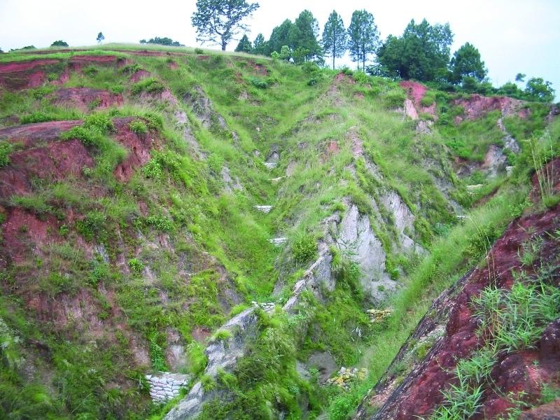
Check dams are small low structures built across a gully or a channel to prevent them from deepening further. These small dams reduce the speed of water flow and minimise the erosive power of runoff. They also promote the deposition of eroded materials to further stabilise the gullies.
Two gullies adjacent to a degraded area of communal grazing land were controlled by constructing check dams and with vegetative measures including planting bamboo. The main purpose was to control the further development of the gullies, which were affecting the adjacent grazing land and blocking a downstream irrigation channel. The site is community land used by the 40 households (240 people) of Dhotra village in the intensively used Jhikhu Khola watershed. Irrigated cropland lies downstream from the site, whilst the site itself is bordered by grazing land, degraded sal-dominated forest, and rainfed forward-sloping terraces.
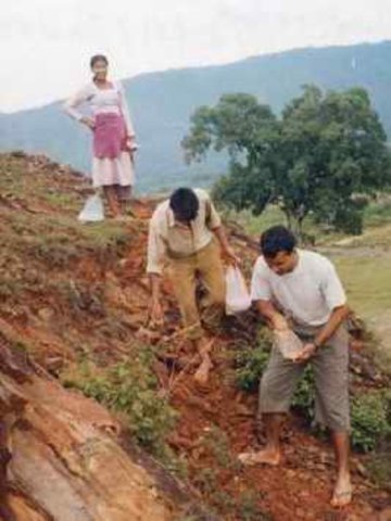
The check dams were made of old cement bags filed with soil and were 1m high with 0.5m deep foundations. The check dams were spaced so that a line joining the top of two adjacent dams had about a 3% slope gradient. Twenty-four check dams were built in the two gullies using a total of 2400 filled cement bags. Forty clumps of bamboo were planted between the dams for stabilisation.
All that is needed to maintain this technology is to inspect the condition of the check dams occasionally, especially before and after the monsoon. Displaced bags should be replaced and the water courses cleared of branches and big stones. Further planting should be carried out if needed.
The case study area has a distinct dry season from November to May and a wet monsoon period from June to October. Annual rainfall is around 1200 mm. The site has red soils that are highly weathered and, if not properly managed, are very susceptible to erosion.
2.3 Photos of the Technology
Media Gallery
2.5 Country/ region/ locations where the Technology has been applied and which are covered by this assessment
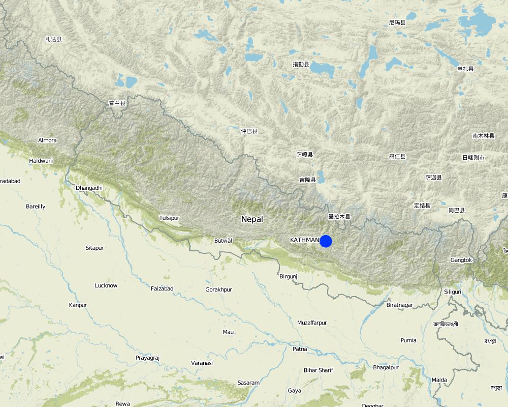
Country:
Nepal
Region/ State/ Province:
Kavre Palanchok/ Dhotra village, Jhikhu Khola watershed
Specify the spread of the Technology:
- evenly spread over an area
If the Technology is evenly spread over an area, specify area covered (in km2):
0.006
Comments:
Total area covered by the SLM Technology is 0.006 km2.
Map
×2.6 Date of implementation
If precise year is not known, indicate approximate date:
- 10-50 years ago
2.7 Introduction of the Technology
Specify how the Technology was introduced:
- through projects/ external interventions
Comments (type of project, etc.):
The basic idea of this technology has its origin in traditional methods. However, villagers approached the People and Resource Dynamics Project (PARDYP) for advice. PARDYP assisted, based on experiences made before with rehabilitation/gully plugging experiments under similar conditions. Mainly developed according to theoretical and site specific knowledge.
3. Classification of the SLM Technology
3.1 Main purpose(s) of the Technology
- reduce, prevent, restore land degradation
- reduce land loss
3.2 Current land use type(s) where the Technology is applied

Grazing land
Extensive grazing:
- Ranching
Comments:
Major land use problems (compiler’s opinion): The major land use problem is the small per capita landholding size for cropping. These holdings are mostly rainfed, have a low soil fertility status and acidity problems, and are susceptible to erosion. Intense rainfall at the beginning of the rainy season causes considerable soil loss (rill and gully erosion).
Major land use problems (land users’ perception): Overgrazing leading to lack of vegetation and gully building.
Ranching: Yes
Future (final) land use (after implementation of SLM Technology): Forests / woodlands: Fp: Plantations, afforestations
Number of growing seasons per year: 3
Longest growing period in days: 150; Longest growing period from month to month: Jun - Oct; Second longest growing period in days: 120; Second longest growing period from month to month: Nov - Feb
3.3 Has land use changed due to the implementation of the Technology?
Has land use changed due to the implementation of the Technology?
- Yes (Please fill out the questions below with regard to the land use before implementation of the Technology)
Grazing land
- Extensive grazing
3.4 Water supply
Water supply for the land on which the Technology is applied:
- rainfed
3.5 SLM group to which the Technology belongs
- improved ground/ vegetation cover
- cross-slope measure
3.6 SLM measures comprising the Technology

vegetative measures
- V1: Tree and shrub cover

structural measures
- S5: Dams, pans, ponds
Comments:
Main measures: vegetative measures, structural measures
Type of vegetative measures: scattered / dispersed
3.7 Main types of land degradation addressed by the Technology

soil erosion by water
- Wg: gully erosion/ gullying
- Wo: offsite degradation effects
Comments:
Main type of degradation addressed: Wg: gully erosion / gullying
Secondary types of degradation addressed: Wo: offsite degradation effects
Main causes of degradation: overgrazing (insufficient forage supply from the private land.), education, access to knowledge and support services (identification of appropriate SWC technologies and appropriate collaborators)
Secondary causes of degradation: deforestation / removal of natural vegetation (incl. forest fires) (for daily household needs ( litter , firewood, timber), other natural causes (avalanches, volcanic eruptions, mud flows, highly susceptible natural resources, extreme topography, etc.) specify (excessive rainfall during pre-monsoon and monsoon), poverty / wealth (to buy planting materials and for logistics), labour availability (for community level social work)
3.8 Prevention, reduction, or restoration of land degradation
Specify the goal of the Technology with regard to land degradation:
- reduce land degradation
4. Technical specifications, implementation activities, inputs, and costs
4.1 Technical drawing of the Technology
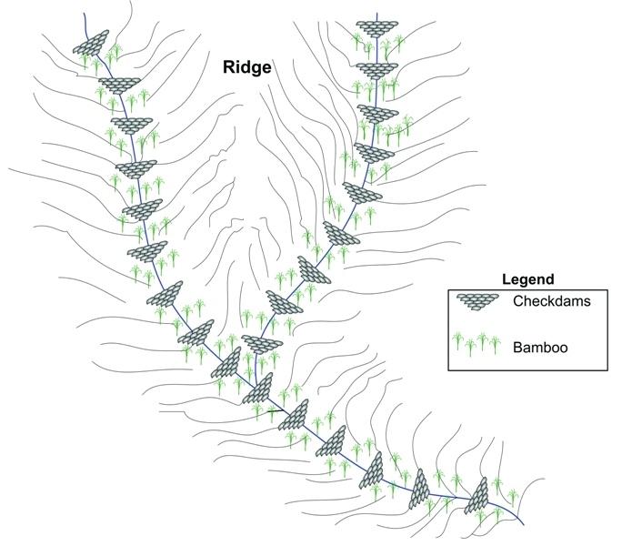
Technical specifications (related to technical drawing):
Schematic drawing of two gullies with 24 check dams and bamboo planted below the check dams for stabilisation
Location: Dhotra. Khabre
Date: 22.6.06
Technical knowledge required for field staff / advisors: low
Technical knowledge required for land users: low
Main technical functions: control of dispersed runoff: impede / retard, sediment retention / trapping, sediment harvesting
Secondary technical functions: reduction of slope angle, increase of infiltration
Scattered / dispersed
Vegetative material: T : trees / shrubs
Number of plants per (ha): 40
Vertical interval between rows / strips / blocks (m): 4 m
Trees/ shrubs species: Bamboo
Slope (which determines the spacing indicated above): 30.00%
If the original slope has changed as a result of the Technology, the slope today is (see figure below): 25.00%
Dam/ pan/ pond
Vertical interval between structures (m): 4 m
Construction material (earth): soil resulting from digging activities from the adjacent grassland was used to fill cement bags for
Slope (which determines the spacing indicated above): 30%
If the original slope has changed as a result of the Technology, the slope today is: 25%
Vegetation is used for stabilisation of structures.
Author:
I. Providoli, A.K.Thaku ICIMOD
4.2 General information regarding the calculation of inputs and costs
other/ national currency (specify):
Nepali Rupee
If relevant, indicate exchange rate from USD to local currency (e.g. 1 USD = 79.9 Brazilian Real): 1 USD =:
73.0
Indicate average wage cost of hired labour per day:
2.00
4.3 Establishment activities
| Activity | Timing (season) | |
|---|---|---|
| 1. | Plantating of bamboo plants (clumps) below the check dams | before onset of monsoon (June) |
| 2. | Placing filled cement bags across gullies to form checkdams | before onset of monsoon (June) |
| 3. | Filling cement bag with soil | before onset of monsoon (June) |
| 4. | Digging trenches for dam foundations | before onset of monsoon (June) |
4.4 Costs and inputs needed for establishment
| Specify input | Unit | Quantity | Costs per Unit | Total costs per input | % of costs borne by land users | |
|---|---|---|---|---|---|---|
| Labour | Building dams and planting bamboo | Persons/day | 18.0 | 2.0 | 36.0 | 100.0 |
| Construction material | Cement bags | ha | 1.0 | 73.0 | 73.0 | |
| Other | Lunch, tea for farmers | ha | 1.0 | 16.0 | 16.0 | |
| Other | Transportation | ha | 1.0 | 14.0 | 14.0 | |
| Total costs for establishment of the Technology | 139.0 | |||||
| Total costs for establishment of the Technology in USD | 1.9 | |||||
Comments:
Duration of establishment phase: 12 month(s)
4.5 Maintenance/ recurrent activities
| Activity | Timing/ frequency | |
|---|---|---|
| 1. | Maintaining gullies: repair or replace damaged check dams, plant | before onset of monsoon (June) |
| 2. | Ensuring good drainage for bamboo | before onset of monsoon (June) |
| 3. | Maintaining gullies: repair or replace damaged check dams,plant more grassesor trees if needed | before onset of monsoon (June)/once a year |
4.6 Costs and inputs needed for maintenance/ recurrent activities (per year)
Comments:
Machinery/ tools: Spade, shovel, Spade, shovel
All costs and amounts were roughly estimated by the technicians and authors in 2004.
5. Natural and human environment
5.1 Climate
Annual rainfall
- < 250 mm
- 251-500 mm
- 501-750 mm
- 751-1,000 mm
- 1,001-1,500 mm
- 1,501-2,000 mm
- 2,001-3,000 mm
- 3,001-4,000 mm
- > 4,000 mm
Agro-climatic zone
- humid
Thermal climate class: subtropics
5.2 Topography
Slopes on average:
- flat (0-2%)
- gentle (3-5%)
- moderate (6-10%)
- rolling (11-15%)
- hilly (16-30%)
- steep (31-60%)
- very steep (>60%)
Landforms:
- plateau/plains
- ridges
- mountain slopes
- hill slopes
- footslopes
- valley floors
Altitudinal zone:
- 0-100 m a.s.l.
- 101-500 m a.s.l.
- 501-1,000 m a.s.l.
- 1,001-1,500 m a.s.l.
- 1,501-2,000 m a.s.l.
- 2,001-2,500 m a.s.l.
- 2,501-3,000 m a.s.l.
- 3,001-4,000 m a.s.l.
- > 4,000 m a.s.l.
Comments and further specifications on topography:
Altitudinal zone: 900 m a.s.l.
Slopes on average: Also very steep
5.3 Soils
Soil depth on average:
- very shallow (0-20 cm)
- shallow (21-50 cm)
- moderately deep (51-80 cm)
- deep (81-120 cm)
- very deep (> 120 cm)
Soil texture (topsoil):
- fine/ heavy (clay)
Topsoil organic matter:
- low (<1%)
If available, attach full soil description or specify the available information, e.g. soil type, soil PH/ acidity, Cation Exchange Capacity, nitrogen, salinity etc.
Soil depth on average: Very shallow at some places parent rockmaterial is exposed but variable.
Soil texture: Red soils with high clay content
Soil fertility was very low before implementation of rehabilitation activities.
Topsoil organic matter before implementation of rehabilitation activities.
Soil drainage / infiltration was poor before implementation of rehabilitation activities.
Soil water storage capacity was very low before implementation of rehabilitation activities.
5.4 Water availability and quality
Water quality (untreated):
poor drinking water (treatment required)
Comments and further specifications on water quality and quantity:
Water quality: More in rainy season (June- September), less in April/May
5.6 Characteristics of land users applying the Technology
Market orientation of production system:
- subsistence (self-supply)
Off-farm income:
- 10-50% of all income
Relative level of wealth:
- poor
Individuals or groups:
- groups/ community
Gender:
- women
- men
Indicate other relevant characteristics of the land users:
Land users applying the Technology are mainly common / average land users
Population density: 200-500 persons/km2
Annual population growth: 2% - 3%
95% of the land users are average wealthy.
3% of the land users are poor.
2% of the land users are poor.
Off-farm income specification: In most farm households, off-farm income plays at least a minor and increasingly a major role. Occasional opportunities for off-farm income present themselves in the form of daily
5.7 Average area of land used by land users applying the Technology
- < 0.5 ha
- 0.5-1 ha
- 1-2 ha
- 2-5 ha
- 5-15 ha
- 15-50 ha
- 50-100 ha
- 100-500 ha
- 500-1,000 ha
- 1,000-10,000 ha
- > 10,000 ha
Is this considered small-, medium- or large-scale (referring to local context)?
- small-scale
Comments:
Only limitied grazing area for whole village.
5.8 Land ownership, land use rights, and water use rights
Land ownership:
- state
Land use rights:
- communal (organized)
6. Impacts and concluding statements
6.1 On-site impacts the Technology has shown
Socio-cultural impacts
community institutions
SLM/ land degradation knowledge
conflict mitigation
Comments/ specify:
At the beginning a few people opposed the activities.
Ecological impacts
Water cycle/ runoff
excess water drainage
Soil
soil cover
soil loss
6.2 Off-site impacts the Technology has shown
downstream siltation
Comments/ specify:
into irrigation canal
6.3 Exposure and sensitivity of the Technology to gradual climate change and climate-related extremes/ disasters (as perceived by land users)
Gradual climate change
Gradual climate change
| Season | increase or decrease | How does the Technology cope with it? | |
|---|---|---|---|
| annual temperature | increase | well |
Climate-related extremes (disasters)
Meteorological disasters
| How does the Technology cope with it? | |
|---|---|
| local rainstorm | not well |
| local windstorm | well |
Climatological disasters
| How does the Technology cope with it? | |
|---|---|
| drought | well |
Hydrological disasters
| How does the Technology cope with it? | |
|---|---|
| general (river) flood | not well |
Other climate-related consequences
Other climate-related consequences
| How does the Technology cope with it? | |
|---|---|
| reduced growing period | well |
6.4 Cost-benefit analysis
How do the benefits compare with the establishment costs (from land users’ perspective)?
Short-term returns:
neutral/ balanced
Long-term returns:
positive
How do the benefits compare with the maintenance/ recurrent costs (from land users' perspective)?
Short-term returns:
neutral/ balanced
Long-term returns:
positive
Comments:
Due to the high establishment costs, the short term benefit for the community only matches the costs. However, in the long-term the environmental benefit of rehabilitated land is high, and economic benefit is positive.
6.5 Adoption of the Technology
- > 50%
If available, quantify (no. of households and/ or area covered):
40 households in an area of 0.006 sq km
Of all those who have adopted the Technology, how many did so spontaneously, i.e. without receiving any material incentives/ payments?
- 0-10%
Comments:
100% of land user families have adopted the Technology with external material support
40 land user families have adopted the Technology with external material support
Comments on acceptance with external material support: survey results
Comments on spontaneous adoption: survey results
There is no trend towards spontaneous adoption of the Technology
Comments on adoption trend: No initiative could be seen in the area.
6.7 Strengths/ advantages/ opportunities of the Technology
| Strengths/ advantages/ opportunities in the land user’s view |
|---|
|
Reduced soil erosion, rill erosion, and top soil loss How can they be sustained / enhanced? Regular maintenance of the structure and grasses is required |
|
The technology is easy to maintain. How can they be sustained / enhanced? As above |
| Strengths/ advantages/ opportunities in the compiler’s or other key resource person’s view |
|---|
|
It's a low cost technology , easy to apply, little knowledge needed. How can they be sustained / enhanced? Regular maintenance of the structure and grasses is required |
|
The effect of the technology can be seen easily. How can they be sustained / enhanced? As above |
7. References and links
7.1 Methods/ sources of information
7.2 References to available publications
Title, author, year, ISBN:
Nakarmi, G. (2000) Soil Erosion Dynamics in the Middle Mountains of Nepal, a report submitted to PARDYP, ICIMOD, Kathmandu
Available from where? Costs?
ICIMOD
Title, author, year, ISBN:
Schreier, H.; Brown, S.; Shah, P. B.; Shrestha, B.; Merz, J. (2002) Jhikhu Khola Watershed – Nepal, CD ROM. Vancouver: Institute for Resources and Environment, University of British Columbia.
Available from where? Costs?
ICIMOD
Title, author, year, ISBN:
Shrestha, B. (2004) Progress Report PARDYP- Nepal. Paper presented at the PARDYP Access Mid Year Meeting, 19-22 July 2004, ICIMOD, Kathmandu
Available from where? Costs?
ICIMOD
Links and modules
Expand all Collapse allLinks
Local initiatives for rehabilitating degraded communal grazing land [Nepal]
Supporting local initiatives and building local capacity for the rehabilitation of degraded communal land in the middle mountains of Nepal.
- Compiler: Madhav Dhakal
Modules
No modules