Drinking water quality improvement through conservation measures [Nepal]
- Creation:
- Update:
- Compiler: Madhav Dhakal
- Editor: –
- Reviewers: David Streiff, Alexandra Gavilano
Samrakshan bidhi dwara piune pani ko gunastar sudhar - Nepali
technologies_1496 - Nepal
View sections
Expand all Collapse all1. General information
1.2 Contact details of resource persons and institutions involved in the assessment and documentation of the Technology
SLM specialist:
SLM specialist:
SLM specialist:
Dongol Bhawani
Nepal
Name of project which facilitated the documentation/ evaluation of the Technology (if relevant)
People and Resource Dynamics Project, Nepal (PARDYP)Name of the institution(s) which facilitated the documentation/ evaluation of the Technology (if relevant)
ICIMOD International Centre for Integrated Mountain Development (ICIMOD) - Nepal1.3 Conditions regarding the use of data documented through WOCAT
The compiler and key resource person(s) accept the conditions regarding the use of data documented through WOCAT:
Yes
1.5 Reference to Questionnaire(s) on SLM Approaches (documented using WOCAT)
Community efforts for improving drinking water quality [Nepal]
Working with communities to demonstrate and disseminate methods for improving drinking water quality using structural and vegetative measures
- Compiler: Madhav Dhakal
2. Description of the SLM Technology
2.1 Short description of the Technology
Definition of the Technology:
Structural and vegetative measures to improve the quality of drinking water contaminated due to poor sanitation and seepage
2.2 Detailed description of the Technology
Description:
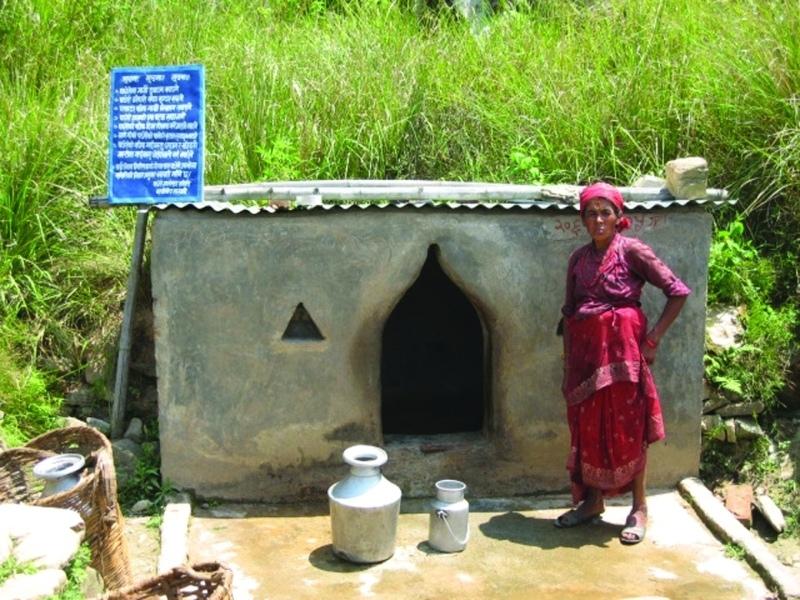
This technology combines structural and vegetative measures to improve the quality of drinking water in an open spring. The quality of water was deteriorating due to poor sanitation and seepage around the spring. The spring was located near to Dhotra village at Barbot sub-settlement, Kabhrepalanchok district. About five households depended on the spring for their drinking water supplies with a further 10 using it regularly and 10-15 using it occasionally during the dry season.
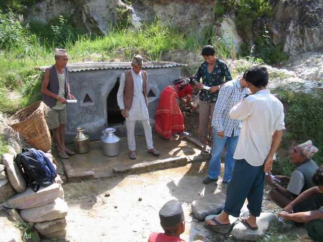
The main purpose of implementing the technology was to improve the quality of drinking water in the spring by preventing it from being contaminated by surface runoff during the rainy season. This technology has long been implemented across Nepal’s midhills. In this case a development project (PARDYP) mobilised the users and provided them with technical and material support to make the improvements.
A spring user group was formed. With project help, it built a walled structure (a spring box) over the spring and check dams around the spring, and planted grasses around the spring box and trees in the catchment. These measures prevented the direct flow of surface water into the spring thus reducing contamination and turbidity. Users built a 1.8m long, 1m wide and 1.5m high spring box with a zinc sheeted roof. Check dams were built across the surrounding gullies and rills. A main 2.5m long, 0.5m wide, and 1m high check dam was constructed near the source to prevent surface runoff from entering the spring. A drainage channel was made to drain off wastewater. Vetiver grass seedlings were planted around the spring box and trees were planted in the adjoining catchment. These activities were carried out at the beginning of the rainy season.
This technology is simple and durable and the only maintenance needed is to keep the surroundings clean and to repair any damage.
The case study area receives about 1200 mm of annual precipitation of which about 80% occurs during the monsoon season (June to September). The area mostly has red soils which are highly weathered and, if not managed properly, are very susceptible to erosive processes.
2.3 Photos of the Technology
Media Gallery
2.5 Country/ region/ locations where the Technology has been applied and which are covered by this assessment
Country:
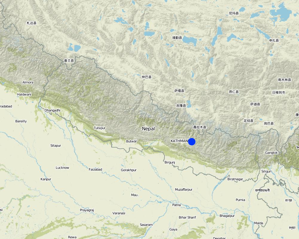
Nepal
Region/ State/ Province:
Kavrepalanchowk district/ Jhikhu Khola watershed
Specify the spread of the Technology:
- evenly spread over an area
If precise area is not known, indicate approximate area covered:
- < 0.1 km2 (10 ha)
Map
×2.6 Date of implementation
If precise year is not known, indicate approximate date:
- more than 50 years ago (traditional)
2.7 Introduction of the Technology
Specify how the Technology was introduced:
- through projects/ external interventions
Comments (type of project, etc.):
Local community, with the contribution from individual community members or from external support have been implementing since generations. In this particular case project mobilized the spring users community and assisted them by providing technical and material support during programme implementing period.
3. Classification of the SLM Technology
3.1 Main purpose(s) of the Technology
- Improve water quality
3.2 Current land use type(s) where the Technology is applied

Grazing land

Other
Specify:
Private land-abondent by village elite, communal land-open grazing
Comments:
Major land use problems (compiler’s opinion): High pressure on limited land resources due to overuse of crop, forest, and grazing lands; increased inputs of agrochemicals which will lead to the deterioration of drinking water quantity and quality
Major land use problems (land users’ perception): Water quality deterioration resulting from poor sanitation
Constraints of wastelands / deserts / glaciers / swamps: private land-abondent by village elite, communal land-open grazing
Number of growing seasons per year: 3
Longest growing period in days: 150; Longest growing period from month to month: Jun - Oct; Second longest growing period in days: 120; Second longest growing period from month to month: Nov - Feb
3.5 SLM group to which the Technology belongs
- surface water management (spring, river, lakes, sea)
3.6 SLM measures comprising the Technology

vegetative measures
- V2: Grasses and perennial herbaceous plants

structural measures
- S5: Dams, pans, ponds
Comments:
Main measures: vegetative measures, structural measures
Type of vegetative measures: scattered / dispersed
3.7 Main types of land degradation addressed by the Technology

soil erosion by water
- Wo: offsite degradation effects
Comments:
Main causes of degradation: overgrazing (uncontrolled access to grazing land), other natural causes (avalanches, volcanic eruptions, mud flows, highly susceptible natural resources, extreme topography, etc.) specify (concentrated runoff during rainy season), education, access to knowledge and support services (lack of knowledge - water quality treatment)
Secondary causes of degradation: deforestation / removal of natural vegetation (incl. forest fires) (uncontrolled access to forest land), poverty / wealth (lack of captial - conservation activities)
3.8 Prevention, reduction, or restoration of land degradation
Specify the goal of the Technology with regard to land degradation:
- reduce land degradation
4. Technical specifications, implementation activities, inputs, and costs
4.1 Technical drawing of the Technology

Technical specifications (related to technical drawing):
Structural and vegetative measures applied to improvewater quality of spring
Location: Barbot Dhotra. Kabhrepalanchowk district
Technical knowledge required for field staff / advisors: moderate
Technical knowledge required for land users: moderate
Main technical functions: control of concentrated runoff: impede / retard, improvement of ground cover
Secondary technical functions: increase / maintain water stored in soil
Scattered / dispersed
Vegetative material: T : trees / shrubs, G : grass
Trees/ shrubs species: Michelia champaca
Grass species: Vetiveria lawsoni
Structural measure: spring box wall
Material: concrete
Height of bunds/banks/others (m): 1.5
Width of bunds/banks/others (m): 1.02
Length of bunds/banks/others (m): 1.89
Structural measure: check dams
Height of bunds/banks/others (m): 1
Width of bunds/banks/others (m): 0.5
Length of bunds/banks/others (m): 2.5
Structural measure: cut-off drain
Material: Stone
Depth of ditches/pits/dams (m): 0.2
Width of ditches/pits/dams (m): 0.25
Length of ditches/pits/dams (m): 3
Construction material (stone): locally available
Construction material (concrete): cement, sand, brick
Author:
Madhav Dhakal, A. K.Thaku
4.2 General information regarding the calculation of inputs and costs
Specify how costs and inputs were calculated:
- per Technology unit
Specify unit:
Spring box and plants
Specify dimensions of unit (if relevant):
1.8m long, 1m wide and 1.5m high with a zinc sheeted roof
Specify currency used for cost calculations:
- USD
Indicate average wage cost of hired labour per day:
1.60
4.3 Establishment activities
| Activity | Timing (season) | |
|---|---|---|
| 1. | Planting vetiver grass around the spring box | beginning of rainy season |
| 2. | Planting tree species in the catchment | beginning of rainy season |
| 3. | Building of check dams to divert stream and gully runoff water | start of the rainy season |
| 4. | Buildingof the spring box | start of the rainy season |
| 5. | Construction of concrete floor in front of spring box | start of the rainy season |
| 6. | Construction of drainage channel | start of the rainy season |
4.4 Costs and inputs needed for establishment
| Specify input | Unit | Quantity | Costs per Unit | Total costs per input | % of costs borne by land users | |
|---|---|---|---|---|---|---|
| Labour | Building spring box and planting trees | Persons/day | 69.0 | 1.6 | 110.4 | 80.0 |
| Plant material | Grass seedlings | unit | 1.0 | 4.0 | 4.0 | |
| Construction material | Cement | unit | 1.0 | 44.0 | 44.0 | |
| Construction material | Gravel / sand | unit | 1.0 | 55.0 | 55.0 | 100.0 |
| Construction material | Bricks | unit | 1.0 | 188.0 | 188.0 | |
| Construction material | Empty sacks | unit | 1.0 | 5.0 | 5.0 | |
| Construction material | Tinc sheet | unit | 1.0 | 16.0 | 16.0 | |
| Construction material | Steel wire | unit | 1.0 | 1.0 | 1.0 | |
| Construction material | Transportation | unit | 1.0 | 10.0 | 10.0 | 15.0 |
| Total costs for establishment of the Technology | 433.4 | |||||
| Total costs for establishment of the Technology in USD | 433.4 | |||||
If land user bore less than 100% of costs, indicate who covered the remaining costs:
PARDYP and District Development Committee
Comments:
Duration of establishment phase: 12 month(s)
4.5 Maintenance/ recurrent activities
| Activity | Timing/ frequency | |
|---|---|---|
| 1. | replacement/ gap filling with new tree seedings | /as required |
| 2. | maintaining height of the planted grass | /as required |
| 3. | Cleaning spring box surroundings | as per need |
| 4. | Maintenance of wall/ floor against damage | as per need |
| 5. | Maintenance of check dam against damage | as per need |
4.6 Costs and inputs needed for maintenance/ recurrent activities (per year)
| Specify input | Unit | Quantity | Costs per Unit | Total costs per input | % of costs borne by land users | |
|---|---|---|---|---|---|---|
| Labour | Maintaining springbox | Persons/day | 2.0 | 1.6 | 3.2 | 100.0 |
| Total costs for maintenance of the Technology | 3.2 | |||||
| Total costs for maintenance of the Technology in USD | 3.2 | |||||
Comments:
Machinery/ tools: hoe,spade, shovel, nails, hammer, pliers, trowel, steel pan bucket, and jug
The cost is only for unit technology, it can not be extrapolated to hector basis, as in 2006.
4.7 Most important factors affecting the costs
Describe the most determinate factors affecting the costs:
Material cost was comparatively high followed by labor cost. For this technology several actors contributed. The land users contributed 61 percent, District Development Committee contributed 26 percent and PARDYP contributed 13 percent, and the department of forest and PARDYP regional coordinator contributed by providing planting materials( vetiver).
5. Natural and human environment
5.1 Climate
Annual rainfall
- < 250 mm
- 251-500 mm
- 501-750 mm
- 751-1,000 mm
- 1,001-1,500 mm
- 1,501-2,000 mm
- 2,001-3,000 mm
- 3,001-4,000 mm
- > 4,000 mm
Specify average annual rainfall (if known), in mm:
1200.00
Agro-climatic zone
- humid
Thermal climate class: subtropics
5.2 Topography
Slopes on average:
- flat (0-2%)
- gentle (3-5%)
- moderate (6-10%)
- rolling (11-15%)
- hilly (16-30%)
- steep (31-60%)
- very steep (>60%)
Landforms:
- plateau/plains
- ridges
- mountain slopes
- hill slopes
- footslopes
- valley floors
Altitudinal zone:
- 0-100 m a.s.l.
- 101-500 m a.s.l.
- 501-1,000 m a.s.l.
- 1,001-1,500 m a.s.l.
- 1,501-2,000 m a.s.l.
- 2,001-2,500 m a.s.l.
- 2,501-3,000 m a.s.l.
- 3,001-4,000 m a.s.l.
- > 4,000 m a.s.l.
Comments and further specifications on topography:
Altitudinal zone: 900 m a.s.l.
5.3 Soils
Soil depth on average:
- very shallow (0-20 cm)
- shallow (21-50 cm)
- moderately deep (51-80 cm)
- deep (81-120 cm)
- very deep (> 120 cm)
Soil texture (topsoil):
- fine/ heavy (clay)
Topsoil organic matter:
- low (<1%)
If available, attach full soil description or specify the available information, e.g. soil type, soil PH/ acidity, Cation Exchange Capacity, nitrogen, salinity etc.
Soil depth on average: Variable
Soil texture: Red soils with high clay content
Soil fertility is very low
Soil drainage / infiltration is medium
Soil water storage capacity is very low
5.4 Water availability and quality
Availability of surface water:
poor/ none
Water quality (untreated):
poor drinking water (treatment required)
Comments and further specifications on water quality and quantity:
Water quality (untreated): More contamination during monsoon season (June- September), source: mainly natural springs
5.6 Characteristics of land users applying the Technology
Off-farm income:
- 10-50% of all income
Relative level of wealth:
- poor
- average
Individuals or groups:
- groups/ community
Gender:
- women
- men
Indicate other relevant characteristics of the land users:
Land users applying the Technology are mainly common / average land users
Population density: 200-500 persons/km2
Annual population growth: 2% - 3%
15% of the land users are average wealthy and own 35% of the land.
85% of the land users are poor and own 65% of the land.
Off-farm income specification: In most farm households, off-farm income plays at least a minor and increasingly a major role. Occasional opportunities for off-farm income present themselves in the form of daily
labour wages. Some households’ members receive regular salaries, whilst an increasing number of Nepalis are
working in India, the Middle East, Malaysia, and elsewhere and sending remittance incomes home.
5.7 Average area of land used by land users applying the Technology
- < 0.5 ha
- 0.5-1 ha
- 1-2 ha
- 2-5 ha
- 5-15 ha
- 15-50 ha
- 50-100 ha
- 100-500 ha
- 500-1,000 ha
- 1,000-10,000 ha
- > 10,000 ha
Is this considered small-, medium- or large-scale (referring to local context)?
- small-scale
5.8 Land ownership, land use rights, and water use rights
Land ownership:
- state
- individual, titled
Land use rights:
- communal (organized)
Water use rights:
- open access (unorganized)
6. Impacts and concluding statements
6.1 On-site impacts the Technology has shown
Socio-economic impacts
Income and costs
workload
Comments/ specify:
decreased women's workload for collecting water, since water is available near to the households
Socio-cultural impacts
health situation
Comments/ specify:
water quality improvement
community institutions
Comments/ specify:
formation of user group; less conflicts for drinking water
SLM/ land degradation knowledge
Comments/ specify:
group discussion, awareness
conflict mitigation
Comments/ specify:
conflicts due to insufficient water quantity. Especially during dry and pre- monsoon months
livelihood and human well-being
Comments/ specify:
Better health due to clean water.
Ecological impacts
Water cycle/ runoff
excess water drainage
Comments/ specify:
due to drainage trench and check dams
Soil
soil cover
Comments/ specify:
due to planted grasses and trees
soil loss
Comments/ specify:
due to check dams
6.3 Exposure and sensitivity of the Technology to gradual climate change and climate-related extremes/ disasters (as perceived by land users)
Gradual climate change
Gradual climate change
| Season | increase or decrease | How does the Technology cope with it? | |
|---|---|---|---|
| annual temperature | increase | well |
Climate-related extremes (disasters)
Meteorological disasters
| How does the Technology cope with it? | |
|---|---|
| local rainstorm | not well |
| local windstorm | well |
Climatological disasters
| How does the Technology cope with it? | |
|---|---|
| drought | not well |
Hydrological disasters
| How does the Technology cope with it? | |
|---|---|
| general (river) flood | not well |
Other climate-related consequences
Other climate-related consequences
| How does the Technology cope with it? | |
|---|---|
| reduced growing period | well |
6.4 Cost-benefit analysis
How do the benefits compare with the establishment costs (from land users’ perspective)?
Short-term returns:
positive
Long-term returns:
very positive
How do the benefits compare with the maintenance/ recurrent costs (from land users' perspective)?
Short-term returns:
very positive
Long-term returns:
very positive
Comments:
Clean water is available immediately after only a little investment. Government and PARDYP support meant that the short-term benefit was positive. Without this support the short-term costs would equal the benefits.
6.5 Adoption of the Technology
- > 50%
If available, quantify (no. of households and/ or area covered):
15 households in an area of 10 ha
Of all those who have adopted the Technology, how many did so spontaneously, i.e. without receiving any material incentives/ payments?
- 0-10%
Comments:
100% of land user families have adopted the Technology with external material support
15 land user families have adopted the Technology with external material support
Comments on acceptance with external material support: survey results
There is a moderate trend towards spontaneous adoption of the Technology
Comments on adoption trend: Local people with inadequate access to drinking water or whose source is contaminated are
likely to adopt the technology after raising the funds themselves.
6.7 Strengths/ advantages/ opportunities of the Technology
| Strengths/ advantages/ opportunities in the land user’s view |
|---|
|
Increased availability of drinking water has reduced women’s workload during the dry season. How can they be sustained / enhanced? Improve the technology by building a closed storage tank. |
| Strengths/ advantages/ opportunities in the compiler’s or other key resource person’s view |
|---|
|
Water turbidity decreased from 23 nephelometric turbidity units (NTU) in August 2004 to 7 NTU in August 2005. How can they be sustained / enhanced? Encourage spring users to plant more multiple grasses and tree species around the catchment area |
|
Faecal contamination decreased from 500 coliform formation units (CFU)/100 ml in August 2004 to 200 CFU/100 ml in August 2005. Similarly, the levels of ammonia (NH3) and nitrate (NO3 in the spring water have decreased (NH3 from 0.5 to 0 mg/l; and NO3 from 0.7 to 0.5 mg/l). Total hardness of spring water remained the same at 30 mg/l. How can they be sustained / enhanced? Regular maintenance, especially cleaning the surrounding area is needed; also need a clean pot for extracting the water. |
6.8 Weaknesses/ disadvantages/ risks of the Technology and ways of overcoming them
| Weaknesses/ disadvantages/ risks in the compiler’s or other key resource person’s view | How can they be overcome? |
|---|---|
| Coliform bacteria are still a problem | Treat the water using SODIS, boiling, fi lters, chlorination or other methods before drinking. |
| The water available during the pre-monsoon season is insufficient for the15 households, leading to conflicts; the water source can be contaminated from unclean water fetching pots. |
The water in the spring box should be siphoned into a storage tank fi tted with an overfl ow mechanism,cleaning outlet, lockable cover, and taps. This would protect the water source from contamination from open access and improve the quality and availability of water. The amount available could be increased by tapping other spring sources. |
7. References and links
7.1 Methods/ sources of information
7.2 References to available publications
Title, author, year, ISBN:
ICIMOD (2007) Good Practices in Watershed Management: Lessons Learned in the Mid Hills of Nepal. Kathmandu: ICIMOD
Available from where? Costs?
ICIMOD
Links and modules
Expand all Collapse allLinks
Community efforts for improving drinking water quality [Nepal]
Working with communities to demonstrate and disseminate methods for improving drinking water quality using structural and vegetative measures
- Compiler: Madhav Dhakal
Modules
No modules