Agrosilvicultura con café orgánico [Costa Rica]
- Creation:
- Update:
- Compiler: Unknown User
- Editor: –
- Reviewers: Deborah Niggli, Alexandra Gavilano
technologies_1511 - Costa Rica
View sections
Expand all Collapse all1. General information
1.3 Conditions regarding the use of data documented through WOCAT
The compiler and key resource person(s) accept the conditions regarding the use of data documented through WOCAT:
Yes
1.4 Declaration on sustainability of the described Technology
Is the Technology described here problematic with regard to land degradation, so that it cannot be declared a sustainable land management technology?
No
2. Description of the SLM Technology
2.1 Short description of the Technology
Definition of the Technology:
Manejo integrado de producción de café con miras a una producción orgánica.
2.2 Detailed description of the Technology
Description:
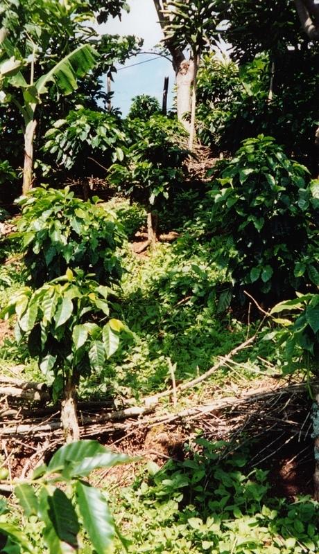
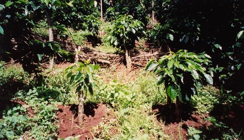
El sistema agrosilvicultura orgánica pretende disminuir la pérdida del suelo, mejorar la infiltración del agua y aumentar la fertilidad del suelo a través de la utilización de barreras vivas, acordona de leña, zanjas y árboles de sombra en combinación de la trilla.
2.3 Photos of the Technology
Media Gallery
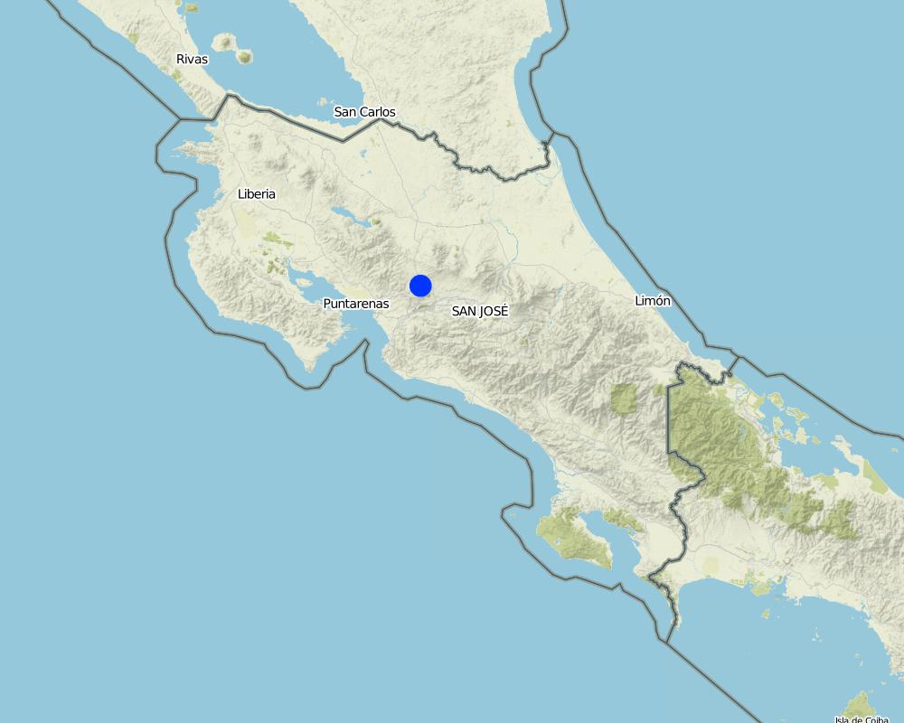
2.5 Country/ region/ locations where the Technology has been applied and which are covered by this assessment
Country:
Costa Rica
Region/ State/ Province:
Alajuela
Specify the spread of the Technology:
- evenly spread over an area
If the Technology is evenly spread over an area, specify area covered (in km2):
2.75
Comments:
2.75 km2.
Este área de la tecnología es uno de 8 áreas pilotos del proyecto MAG/FAO.
Map
×2.6 Date of implementation
If precise year is not known, indicate approximate date:
- less than 10 years ago (recently)
2.7 Introduction of the Technology
Specify how the Technology was introduced:
- through projects/ external interventions
3. Classification of the SLM Technology
3.1 Main purpose(s) of the Technology
- improve production
3.2 Current land use type(s) where the Technology is applied
Land use mixed within the same land unit:
Yes
Specify mixed land use (crops/ grazing/ trees):
- Agroforestry

Cropland
- Annual cropping
- Perennial (non-woody) cropping
- Tree and shrub cropping
Tree and shrub cropping - Specify crops:
- coffee, shade grown
Number of growing seasons per year:
- 2
Specify:
210 Días, de Mayo hasta Noviembre y 150 días, de Diciembre hasta Abril
Comments:
Problemas principales del uso de tierras: Uso excesivo de herbicidas, descubierto del suelo unido a la poca utilización de suelos. El uso pasado que se dio al suelo (tabaco), uso excesivo de herbicidas.
Tipo de sistema de cultivo y cultivos principales: Sistema agrosilvicultura: café arbolado en combinación de frutas y verduras.
3.5 SLM group to which the Technology belongs
- integrated crop-livestock management
3.7 Main types of land degradation addressed by the Technology

soil erosion by water
- Wt: loss of topsoil/ surface erosion
- Wg: gully erosion/ gullying

chemical soil deterioration
- Cn: fertility decline and reduced organic matter content (not caused by erosion)

water degradation
- Ha: aridification
4. Technical specifications, implementation activities, inputs, and costs
4.1 Technical drawing of the Technology
Technical specifications (related to technical drawing):
Conocimientos técnicos necesarios para el personal / asesores de campo: medio
Conocimientos técnicos necesarios para los usuarios de la tierra: medio
Pendiente (que determina el espaciamiento indicado arriba): 60.00%
4.2 General information regarding the calculation of inputs and costs
other/ national currency (specify):
colones
If relevant, indicate exchange rate from USD to local currency (e.g. 1 USD = 79.9 Brazilian Real): 1 USD =:
315.0
Indicate average wage cost of hired labour per day:
7.00
4.3 Establishment activities
| Activity | Timing (season) | |
|---|---|---|
| 1. | demarcación | febrero-abril |
| 2. | hacer huecos | abril |
| 3. | siembra | mayo |
4.5 Maintenance/ recurrent activities
| Activity | Timing/ frequency | |
|---|---|---|
| 1. | poda | enero-abril / 1 vez por año |
| 2. | arreglo de sombra | mayo-agosto / 2 veces por año |
| 3. | aplicación enmienda | abril / según análisis del suelo |
| 4. | fertilización | mayo, agosto, noviembre / 3 veces por año |
| 5. | atomizaciones | mayo, agosto, noviembre / 3 veces por año |
| 6. | recolección de cosecha | noviembre-febrero / 1 vez por año |
4.6 Costs and inputs needed for maintenance/ recurrent activities (per year)
Comments:
Promedios costos por fanega de café por año (vease calculación adicional).
4.7 Most important factors affecting the costs
Describe the most determinate factors affecting the costs:
Pendiente fuerte, costo mano de obra, costo de los insumos.
5. Natural and human environment
5.1 Climate
Annual rainfall
- < 250 mm
- 251-500 mm
- 501-750 mm
- 751-1,000 mm
- 1,001-1,500 mm
- 1,501-2,000 mm
- 2,001-3,000 mm
- 3,001-4,000 mm
- > 4,000 mm
Specifications/ comments on rainfall:
1910 mm
Agro-climatic zone
- humid
- sub-humid
bosque húmedo premontano
5.2 Topography
Slopes on average:
- flat (0-2%)
- gentle (3-5%)
- moderate (6-10%)
- rolling (11-15%)
- hilly (16-30%)
- steep (31-60%)
- very steep (>60%)
Landforms:
- plateau/plains
- ridges
- mountain slopes
- hill slopes
- footslopes
- valley floors
Altitudinal zone:
- 0-100 m a.s.l.
- 101-500 m a.s.l.
- 501-1,000 m a.s.l.
- 1,001-1,500 m a.s.l.
- 1,501-2,000 m a.s.l.
- 2,001-2,500 m a.s.l.
- 2,501-3,000 m a.s.l.
- 3,001-4,000 m a.s.l.
- > 4,000 m a.s.l.
5.3 Soils
Soil depth on average:
- very shallow (0-20 cm)
- shallow (21-50 cm)
- moderately deep (51-80 cm)
- deep (81-120 cm)
- very deep (> 120 cm)
Soil texture (topsoil):
- medium (loamy, silty)
- fine/ heavy (clay)
Topsoil organic matter:
- medium (1-3%)
5.6 Characteristics of land users applying the Technology
Off-farm income:
- > 50% of all income
Relative level of wealth:
- poor
- average
Level of mechanization:
- manual work
Indicate other relevant characteristics of the land users:
Densedad de población: 100-200 personas/km2
Crecimiento anual de población: 1% - 2%
Especificación del ingreso fuera de la finca: Muchos habitantes se trasladan a trabajar en manufacturas y "polleras" (procesan el pollo), los insumos de la finca no son suficientes para toda la familia.
5.8 Land ownership, land use rights, and water use rights
Land use rights:
- communal (organized)
- individual
6. Impacts and concluding statements
6.5 Adoption of the Technology
Comments:
100% de las familias de usuarios de la tierra han adoptado la tecnología con soporte de material externo
45 familias de usuarios de la tierra han adoptado la tecnología con apoyo material externo
70% de las familias de usuarios de la tierra han adoptado la tecnología sin ningún tipo de apoyo material externo
32 familias de usuarios de la tierra han adoptado la Tecnología sin ningún tipo de apoyo material externo
Existe una tendencia moderada hacia la adopción espontánea de la Tecnología.
7. References and links
7.1 Methods/ sources of information
- field visits, field surveys
- interviews with land users
When were the data compiled (in the field)?
06/10/2000
Links and modules
Expand all Collapse allLinks
No links
Modules
No modules