Irrigation and grassing of the high semi-desert grassland [Tajikistan]
- Creation:
- Update:
- Compiler: Gulniso Nekushoeva
- Editor: –
- Reviewers: David Streiff, Alexandra Gavilano
Орошение и залужение высокогорных полупустынных пастбищ
technologies_1539 - Tajikistan
View sections
Expand all Collapse all1. General information
1.2 Contact details of resource persons and institutions involved in the assessment and documentation of the Technology
SLM specialist:
SLM specialist:
Name of the institution(s) which facilitated the documentation/ evaluation of the Technology (if relevant)
Tajik Soil Insitute (Tajik Soil Institute) - TajikistanName of the institution(s) which facilitated the documentation/ evaluation of the Technology (if relevant)
CDE Centre for Development and Environment (CDE Centre for Development and Environment) - Switzerland1.3 Conditions regarding the use of data documented through WOCAT
The compiler and key resource person(s) accept the conditions regarding the use of data documented through WOCAT:
Yes
2. Description of the SLM Technology
2.1 Short description of the Technology
Definition of the Technology:
Irrigation of semi-arid highland pastures contributes to rapid growth of natural grass, whereas removing stones in the pastures improves the surface of the area and increases the available pasture area.
2.2 Detailed description of the Technology
Description:
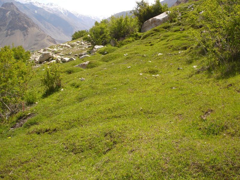
Pastures in Vankal are mainly located on the stony mountain slopes, which are insuitable for farming. Poor and partually shrubby vegetation and overgrazing cause low productivity of the pastures. Residents of the Varshez village found a way to improve the pasture condition and to increase fodder production. They began to irrigate the entire land area within the village borders, i.e. lands between kitchen gardens, around the crop lands where grain, potatoes and fodder have been planted, and up until the big irrigation canal (located above the village). Irrigation canal has already existed, so extra work was not required. As a result, soon after, in addition to the usual pasture above the irrigated area, villagers could use the high productive spring and autumn pastures within their village. Irrigation and removing stones significantly improved the productivity of that land area and increase of vegetation types improved the quality of the fodder. Thus, gradually low-productive and stony pastures became high-productive pastures with high-quality natural grass.
Purpose of the Technology: Increasing the productivity of stony and slopy pastures near the village. Ensuring fodder for livestock in spring and autumn.
Establishment / maintenance activities and inputs: Financial and labour inputs were not required for the implementation of this technology (to establish an irrigation system). Available pasture area was divided by the number of the households, then stones in the area were removed and a small irrigation system was created below the irrigation canal to bring the water to particular areas.
Natural / human environment: Varshez village is located in the GBAO rayon, Vankala djamoat on the left bank of Gunt river. The highest spot reaches up to 3200-3300m asl. Summer period is short. Last years, night frosts have often been happening. Annual rainfall - 120-150 mm. Local people heavily depend on their own production. Their main occupation includes yak breeging. In autumn, yaks (or their meat) is exchanged for food, coal, kerosene and clothes. Non-grazing period last 6-7 months, therefore, saficient amount of fodder must be prepared. Since markets are located far away, there is also an urgent need for winter fodder for cattle. Pastures between the village and above the canal are heavily degraded: the area is stony with only xerophic half-shrubby vegetation growing on it (very few edibe vegetation). After implemeting this technolology, such land areas become productive spring-autumn pastures. In summer, when cattle is grazed in far away pastures, new grasses grow in spring-autumn pastures. Sometimes there can be even enough grass for hay preparation.
2.3 Photos of the Technology
Media Gallery
2.5 Country/ region/ locations where the Technology has been applied and which are covered by this assessment
Country:
Tajikistan
Region/ State/ Province:
Tajikistan
Further specification of location:
GBAO, Shugnan
Specify the spread of the Technology:
- evenly spread over an area
If precise area is not known, indicate approximate area covered:
- < 0.1 km2 (10 ha)
Comments:
Total area covered by the SLM Technology is 0.08 m2.
This technology was implemented in the pastures of a single village, but potential for further replications does exist.
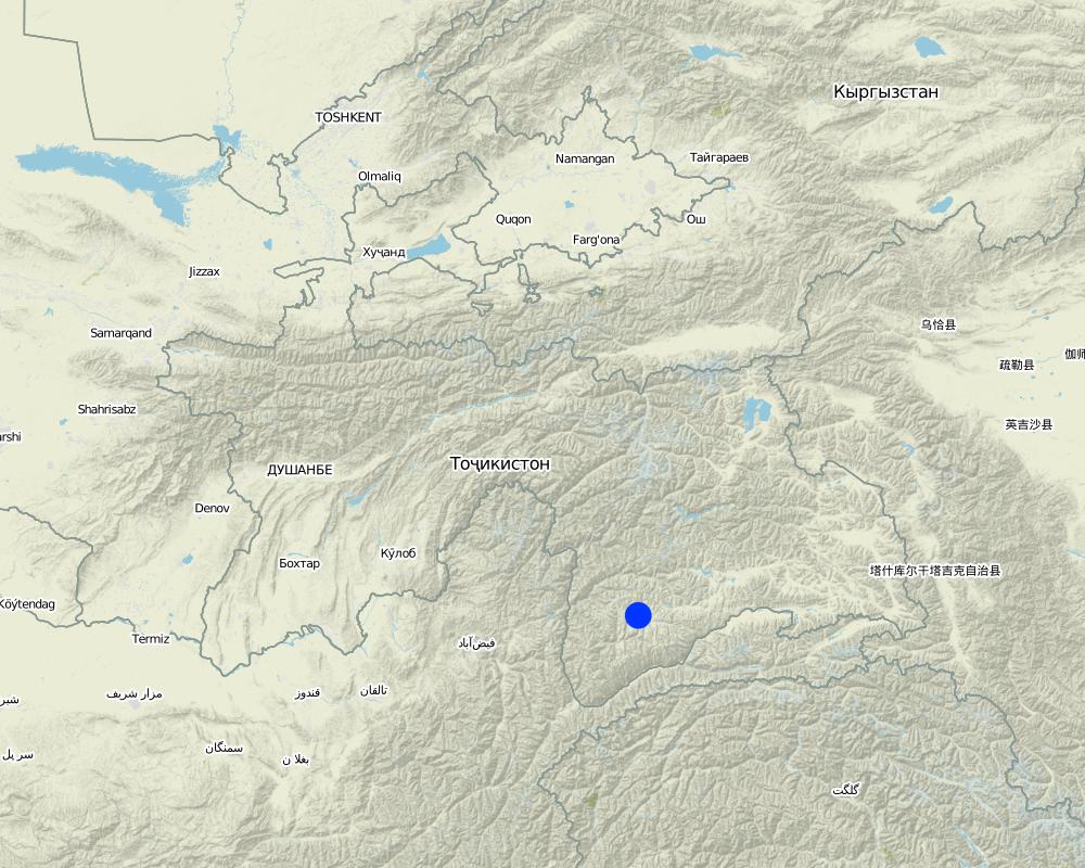
Map
×2.6 Date of implementation
If precise year is not known, indicate approximate date:
- 10-50 years ago
2.7 Introduction of the Technology
Specify how the Technology was introduced:
- through land users' innovation
Comments (type of project, etc.):
After 1990s, about 16-18 years
3. Classification of the SLM Technology
3.1 Main purpose(s) of the Technology
- reduce, prevent, restore land degradation
3.2 Current land use type(s) where the Technology is applied

Cropland
- Annual cropping
- Perennial (non-woody) cropping
Annual cropping - Specify crops:
- cereals - rye
- cereals - barley
- root/tuber crops - potatoes
- Sainfoin, Grain
Number of growing seasons per year:
- 1
Specify:
Longest growing period in days: 90

Grazing land
Extensive grazing:
- Nomadism
- Semi-nomadic pastoralism
Animal type:
- cattle - dairy
- In summer time, the cattle is grazed on the far away pastures. Yaks (if they have) are brough to Murgab. In winter cattle stay in the stalls (from october to may). Only yaks are grazed.

Forest/ woodlands
- Will trees, Buckthorn
Products and services:
- Timber
- Fuelwood
- Grazing/ browsing
Comments:
Major land use problems (compiler’s opinion): Low natural fertility of the stony soil, low productivity of semiarid rangeland, overgrazing (grazing without considering the pasture capacity), pasture degradation.
Major land use problems (land users’ perception): Low-productivity of degraded pastures, problems connected with feeding cattle during the long 6-7 months of non-grazing period.
Nomadism: In summer time, the cattle is grazed on the far away pastures. Yaks (if they have) are brough to Murgab.
Semi-nomadism / pastoralism: In winter cattle stay in the stalls (from october to may). Only yaks are grazed.
Selective felling of (semi-) natural forests: Willow trees: after every 3 years upper branches are cut down (in spring and autumn). Lower branches of the seabuckthorn is cut down when a family needs it.
Problems / comments regarding forest use: Allthough willow and buckthorn are fast-growing trees, they require a lot of water. Therefore their expansion depends on the availability of irrigation water.
Forest products and services: timber, fuelwood, grazing / browsing
Future (final) land use (after implementation of SLM Technology): Grazing land: Gi: Intensive grazing/ fodder production
Constraints of wastelands / deserts / glaciers / swamps: Mismanagement
3.3 Has land use changed due to the implementation of the Technology?
Grazing land
Comments:
Future (final) land use (after implementation of SLM Technology): Grazing land: Gi: Intensive grazing/ fodder production
Grazing land: Ge: Extensive grazing land
3.4 Water supply
Water supply for the land on which the Technology is applied:
- full irrigation
Comments:
Водопотребление: полностью орошаемое, полностью орошаемое
Number of growing seasons per year:
1
Specify:
Longest growing period in days: 90
3.5 SLM group to which the Technology belongs
- pastoralism and grazing land management
- improved ground/ vegetation cover
3.6 SLM measures comprising the Technology

vegetative measures
- V1: Tree and shrub cover
- V2: Grasses and perennial herbaceous plants
- V5: Others

management measures
- M1: Change of land use type
- M5: Control/ change of species composition
Comments:
Main measures: vegetative measures, management measures
3.7 Main types of land degradation addressed by the Technology

soil erosion by water
- Wg: gully erosion/ gullying

chemical soil deterioration
- Cn: fertility decline and reduced organic matter content (not caused by erosion)

biological degradation
- Bc: reduction of vegetation cover
- Bq: quantity/ biomass decline
- Bl: loss of soil life

water degradation
- Ha: aridification
Comments:
Main type of degradation addressed: Wg: gully erosion / gullying, Bc: reduction of vegetation cover, Ha: aridification
Secondary types of degradation addressed: Cn: fertility decline and reduced organic matter content, Bq: quantity / biomass decline, Bl: loss of soil life
Main causes of degradation: soil management (The need for self-sufficiency from 1992-93s has forced the population to increase the number of livestock to exchange it for other products.), overgrazing (Inability to graze livestock in the far away pastures and concentration of too many animals in the small area.), droughts (High aridity, low rainfall, poor vegetation.), population pressure (Unregulated grazing), poverty / wealth (Too many poor families), war and conflicts (Fully self-sufficeint since the crisis of the 1990s.)
Secondary causes of degradation: deforestation / removal of natural vegetation (incl. forest fires) (Lack of electricity, and later, its provision for only 2-3 hours per day forced people to cut down all trees around.), over-exploitation of vegetation for domestic use, labour availability (Employment opportunities exist only at the local school or in the hospital of the djamoat, however all places there are occupied. Taxi-driving is nother possibility.), inputs and infrastructure: (roads, markets, distribution of water points, other, …) (Bad road conditions, long distance to markets.), education, access to knowledge and support services (There is a school, 2 mills and a shop.)
3.8 Prevention, reduction, or restoration of land degradation
Specify the goal of the Technology with regard to land degradation:
- reduce land degradation
- restore/ rehabilitate severely degraded land
Comments:
Secondary goals: prevention of land degradation
4. Technical specifications, implementation activities, inputs, and costs
4.1 Technical drawing of the Technology
Technical specifications (related to technical drawing):
Main technical functions: improvement of ground cover, improvement of surface structure (crusting, sealing), increase in organic matter, increase of biomass (quantity)
Secondary technical functions: improvement of topsoil structure (compaction), improvement of subsoil structure (hardpan), stabilisation of soil (eg by tree roots against land slides), increase in nutrient availability (supply, recycling,…), increase / maintain water stored in soil, promotion of vegetation species and varieties (quality, eg palatable fodder)
Trees/ shrubs species: Dog roses/hips - 1.5-2 m, natural willow along the canals
Grass species: Natural diversity of grass; after the irrgation grass began to grow well
Slope (which determines the spacing indicated above): 0%
Gradient along the rows / strips: 0%
Change of land use practices / intensity level: Low-productive pastures became high-productive irrigated pastures
Layout change according to natural and human environment: Lands between the households and below the main irrigation canal have been irrigated and grassed. Lands above the canal are naturally stony lands.
Control / change of species composition: After irrigation, natural grass began to grow, quantity of a fodder grass incresed and weeds were cut.
4.2 General information regarding the calculation of inputs and costs
other/ national currency (specify):
somoni
If relevant, indicate exchange rate from USD to local currency (e.g. 1 USD = 79.9 Brazilian Real): 1 USD =:
4.52
Indicate average wage cost of hired labour per day:
7.00
4.3 Establishment activities
| Activity | Timing (season) | |
|---|---|---|
| 1. | Cutting the poisonous vegetation and weeds | 2 p/d |
| 2. | Irrigation |
4.5 Maintenance/ recurrent activities
| Activity | Timing/ frequency | |
|---|---|---|
| 1. | Removing stones | each year/spring |
| 2. | Irrigation | |
| 3. | Cutting down dry branches of the dog rose | annually/spring, autumn |
| 4. | Pasture irrigation | 4 times/month |
| 5. | Selective mowving down of the natural grass | annually/2 times in summer |
| 6. | Collecting hips | annually/autumn |
4.6 Costs and inputs needed for maintenance/ recurrent activities (per year)
Comments:
Machinery/ tools: manual labour + shovel for irrgation, manual work, ploughing (ox, shovel, sickle), manual labour, sickle, shovel
5. Natural and human environment
5.1 Climate
Annual rainfall
- < 250 mm
- 251-500 mm
- 501-750 mm
- 751-1,000 mm
- 1,001-1,500 mm
- 1,501-2,000 mm
- 2,001-3,000 mm
- 3,001-4,000 mm
- > 4,000 mm
Specifications/ comments on rainfall:
170-200 mm rainfall (mainly in spring and autumn).
Agro-climatic zone
- arid
Thermal climate class: boreal. Only in summer the temperature goes above 10C
5.2 Topography
Slopes on average:
- flat (0-2%)
- gentle (3-5%)
- moderate (6-10%)
- rolling (11-15%)
- hilly (16-30%)
- steep (31-60%)
- very steep (>60%)
Landforms:
- plateau/plains
- ridges
- mountain slopes
- hill slopes
- footslopes
- valley floors
Altitudinal zone:
- 0-100 m a.s.l.
- 101-500 m a.s.l.
- 501-1,000 m a.s.l.
- 1,001-1,500 m a.s.l.
- 1,501-2,000 m a.s.l.
- 2,001-2,500 m a.s.l.
- 2,501-3,000 m a.s.l.
- 3,001-4,000 m a.s.l.
- > 4,000 m a.s.l.
Comments and further specifications on topography:
Slopes on average: Also hilly (16-30%)
Altitudinal zone: 3200 - 3300m a.s.l.
Landforms: The technology is used in high and slopy pastures and foothill areas
5.3 Soils
Soil depth on average:
- very shallow (0-20 cm)
- shallow (21-50 cm)
- moderately deep (51-80 cm)
- deep (81-120 cm)
- very deep (> 120 cm)
Soil texture (topsoil):
- coarse/ light (sandy)
- medium (loamy, silty)
Topsoil organic matter:
- high (>3%)
- medium (1-3%)
If available, attach full soil description or specify the available information, e.g. soil type, soil PH/ acidity, Cation Exchange Capacity, nitrogen, salinity etc.
Soil depth on average: Very stony below 40-50 cm
Soil texture: Often upper layers are loamy, lower parts are sandy and very stony
Soil fertility is naturally low due to low temperature and little vegetation but becomes medium at irrigated pastures, which have a good natural cover for processing into humus.
Topsoil organic matter: Forest belt - 2-3%, sainfoin - 33% and 1.3 - 1.4% on the pastures; grain - 1.7-2.4% .
Soil drainage / infiltration is good
Soil water storage capacity s low because the soil is loamy
5.4 Water availability and quality
Ground water table:
5-50 m
Availability of surface water:
good
Water quality (untreated):
good drinking water
Comments and further specifications on water quality and quantity:
Ground water table: Gunt river flows nearby
Availability of surface water: Gunt river is nearby, but the fields are located above its level. Therefore, there was an irrigation canal built above the village.
5.5 Biodiversity
Species diversity:
- high
5.6 Characteristics of land users applying the Technology
Market orientation of production system:
- subsistence (self-supply)
- mixed (subsistence/ commercial)
Off-farm income:
- 10-50% of all income
Relative level of wealth:
- poor
- average
Individuals or groups:
- individual/ household
Level of mechanization:
- animal traction
Gender:
- women
- men
Indicate other relevant characteristics of the land users:
Land users applying the Technology are mainly common / average land users
Population density: < 10 persons/km2
Annual population growth: < 0.5%
2% of the land users are rich.
58% of the land users are average wealthy.
40% of the land users are poor.
Market orientation of production system: Livestock products are mainly used for household consumption and for exchange with other products and things. Normally produced products and fodder is not sufficient, therefore, people have to buy additional fodder and products, but meat is sold. Some households sell milk products on the market in Khorog city (97 km away).
Level of mechanization: Oxes are used for ploughing.
5.7 Average area of land used by land users applying the Technology
- < 0.5 ha
- 0.5-1 ha
- 1-2 ha
- 2-5 ha
- 5-15 ha
- 15-50 ha
- 50-100 ha
- 100-500 ha
- 500-1,000 ha
- 1,000-10,000 ha
- > 10,000 ha
Is this considered small-, medium- or large-scale (referring to local context)?
- medium-scale
Comments:
Average area of land owned or leased by land users applying the Technology:Also < 0.5 ha 1-2 ha and 5-15 ha
5.8 Land ownership, land use rights, and water use rights
Land ownership:
- state
Land use rights:
- leased
Water use rights:
- communal (organized)
5.9 Access to services and infrastructure
health:
- poor
- moderate
- good
education:
- poor
- moderate
- good
technical assistance:
- poor
- moderate
- good
employment (e.g. off-farm):
- poor
- moderate
- good
markets:
- poor
- moderate
- good
energy:
- poor
- moderate
- good
roads and transport:
- poor
- moderate
- good
drinking water and sanitation:
- poor
- moderate
- good
financial services:
- poor
- moderate
- good
6. Impacts and concluding statements
6.1 On-site impacts the Technology has shown
Socio-economic impacts
Production
crop production
Comments/ specify:
Productivity of pastures has significantly increased.
fodder production
Comments/ specify:
More hay production in comparison with other neighboring pastures.
fodder quality
Comments/ specify:
High-quality hay.
animal production
Comments/ specify:
Increased fodder security.
wood production
Comments/ specify:
Shrubby willow grows in the irrigation dithes, high dog roses grow on the pastures, branches of which are annually cut down for firewood
risk of production failure
Comments/ specify:
Irrigation contributes to the increase of edible plants.
product diversity
Comments/ specify:
Firewood, hay and fresh grass, hips full of vitamins.
land management
Comments/ specify:
The larger the area of irrigated pasture, the fewer problems connected with grazing in spring and autumn.
Income and costs
farm income
Comments/ specify:
Increased fatness of cattle and possible high income from the sale of the livestock.
Socio-cultural impacts
food security/ self-sufficiency
Comments/ specify:
Fodder security is improving.
Livelihood and human well-being
Comments/ specify:
Main income comes from animal husbandry. Pasture irrigation allows to increase the quantity of fodder.
Ecological impacts
Soil
soil moisture
Comments/ specify:
Irrigation once in a week provide sufficient moisture for vegetation.
soil cover
Comments/ specify:
Stones are removed, surface is covered with grass
nutrient cycling/ recharge
Comments/ specify:
Nutrients are here higher than in the non-irrigated pastures
soil organic matter/ below ground C
Biodiversity: vegetation, animals
biomass/ above ground C
Comments/ specify:
The soil is covered with dense vegetation and shrubs (increase of biomass)
plant diversity
Comments/ specify:
Increase in diversity of mesophytic herbs and edible shrubs.
animal diversity
Comments/ specify:
The number of soil fauna and insects has increased
beneficial species
Comments/ specify:
Their number has increased.
habitat diversity
Comments/ specify:
Some farmers sow alfalfa.
pest/ disease control
Comments/ specify:
Poisonous and inedible grass is mowed down before they start flowering.
Climate and disaster risk reduction
drought impacts
Comments/ specify:
Irrigation reduced the risk of drought.
emission of carbon and greenhouse gases
6.3 Exposure and sensitivity of the Technology to gradual climate change and climate-related extremes/ disasters (as perceived by land users)
Gradual climate change
Gradual climate change
| Season | increase or decrease | How does the Technology cope with it? | |
|---|---|---|---|
| annual temperature | increase | well |
Climate-related extremes (disasters)
Meteorological disasters
| How does the Technology cope with it? | |
|---|---|
| local rainstorm | well |
| local windstorm | well |
Climatological disasters
| How does the Technology cope with it? | |
|---|---|
| drought | not well |
Hydrological disasters
| How does the Technology cope with it? | |
|---|---|
| general (river) flood | well |
Other climate-related consequences
Other climate-related consequences
| How does the Technology cope with it? | |
|---|---|
| reduced growing period | not well |
| lower temperature (frost) |
Comments:
Removing stones and cleaning from weeds
6.4 Cost-benefit analysis
How do the benefits compare with the establishment costs (from land users’ perspective)?
Short-term returns:
positive
Long-term returns:
very positive
How do the benefits compare with the maintenance/ recurrent costs (from land users' perspective)?
Short-term returns:
very positive
Long-term returns:
very positive
6.5 Adoption of the Technology
If available, quantify (no. of households and/ or area covered):
NA
Of all those who have adopted the Technology, how many did so spontaneously, i.e. without receiving any material incentives/ payments?
- 91-100%
Comments:
100% of land user families have adopted the Technology without any external material support
There is a moderate trend towards spontaneous adoption of the Technology
6.7 Strengths/ advantages/ opportunities of the Technology
| Strengths/ advantages/ opportunities in the land user’s view |
|---|
| Possibility for hay-preparation nearby. |
| Possibility to graze cattle nearby. |
| Strengths/ advantages/ opportunities in the compiler’s or other key resource person’s view |
|---|
|
Irrigated and grassed pastures provide high-quality fodder for the cattle. How can they be sustained / enhanced? It is necessary to sow seeds of alfalfa ans sainfoin. |
|
Irrigated pasture area can be increased as kilometers long irrgation canal pass through the low-productive desert pastures. How can they be sustained / enhanced? It is necessary to establish an irrgation system below the main canal and to remove stones. Responsibility should be divided among households. |
6.8 Weaknesses/ disadvantages/ risks of the Technology and ways of overcoming them
| Weaknesses/ disadvantages/ risks in the land user’s view | How can they be overcome? |
|---|---|
| Decrease of available land around the homes for other purposes (e.g. a play ground for children). |
| Weaknesses/ disadvantages/ risks in the compiler’s or other key resource person’s view | How can they be overcome? |
|---|---|
| Strong dependence on irrigation. | Regular provision of irrigation water. |
7. References and links
7.1 Methods/ sources of information
7.2 References to available publications
Title, author, year, ISBN:
Справочник по климату СССР, вып. 31, Таджикская ССР, частьII. гидрометеорологическое издательство, Ленинград, 1966,228с.
Title, author, year, ISBN:
Справочник по климату СССР, вып. 31, Таджикская ССР, частьIV, гидрометеорологическое, Ленинград, 1966, 212с.
Links and modules
Expand all Collapse allLinks
No links
Modules
No modules