Sustainable land management using controlled gullying [Nepal]
- Creation:
- Update:
- Compiler: Shreedip Sigdel
- Editor: –
- Reviewers: David Streiff, Alexandra Gavilano
Jagidol chetra ma kholsi sudhar dwara digo bhu bewasthapan (Main Contributor: Sabita Khanal, Kathmandu University)
technologies_1684 - Nepal
View sections
Expand all Collapse all1. General information
1.2 Contact details of resource persons and institutions involved in the assessment and documentation of the Technology
SLM specialist:
Name of the institution(s) which facilitated the documentation/ evaluation of the Technology (if relevant)
Kathmandu University (KU) - NepalName of the institution(s) which facilitated the documentation/ evaluation of the Technology (if relevant)
ICIMOD International Centre for Integrated Mountain Development (ICIMOD) - Nepal1.3 Conditions regarding the use of data documented through WOCAT
The compiler and key resource person(s) accept the conditions regarding the use of data documented through WOCAT:
Yes
1.5 Reference to Questionnaire(s) on SLM Approaches (documented using WOCAT)
Community-based approach in Erosion Control [Azerbaijan]
The unsustainable use of pastures and forest areas leads to erosion, degradation, desertification and loss of biodiversity in high mountain areas of the South Caucasus. In the village Ehen in the Ismayilli district in Azerbaijan, a community-based approach for erosion control was developed in a participative way. Together with village …
- Compiler: Hanns Kirchmeir
Protected gullies – a traditional sustainable land management … [Nepal]
Protected gullying is a sustainable land management practice initiated and maintained by the traditional community approach; it is based on indigenous knowledge and uses only locally available materials.
- Compiler: Shreedip Sigdel
2. Description of the SLM Technology
2.1 Short description of the Technology
Definition of the Technology:
An indigenous technology to help control channelled water during the rainy season and conserve it during the dry season
2.2 Detailed description of the Technology
Description:
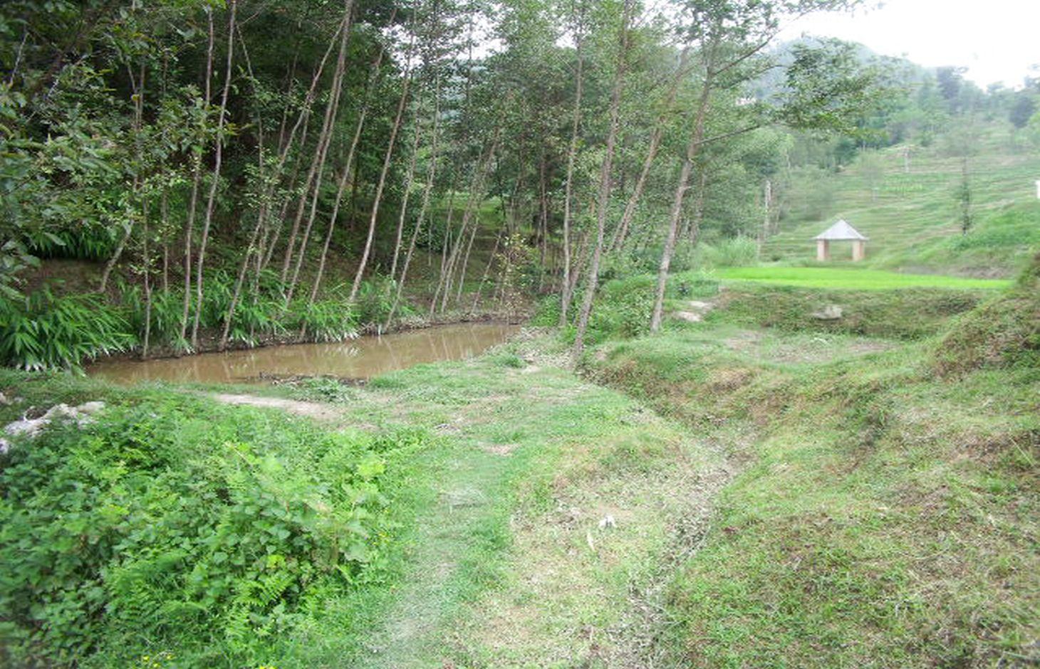
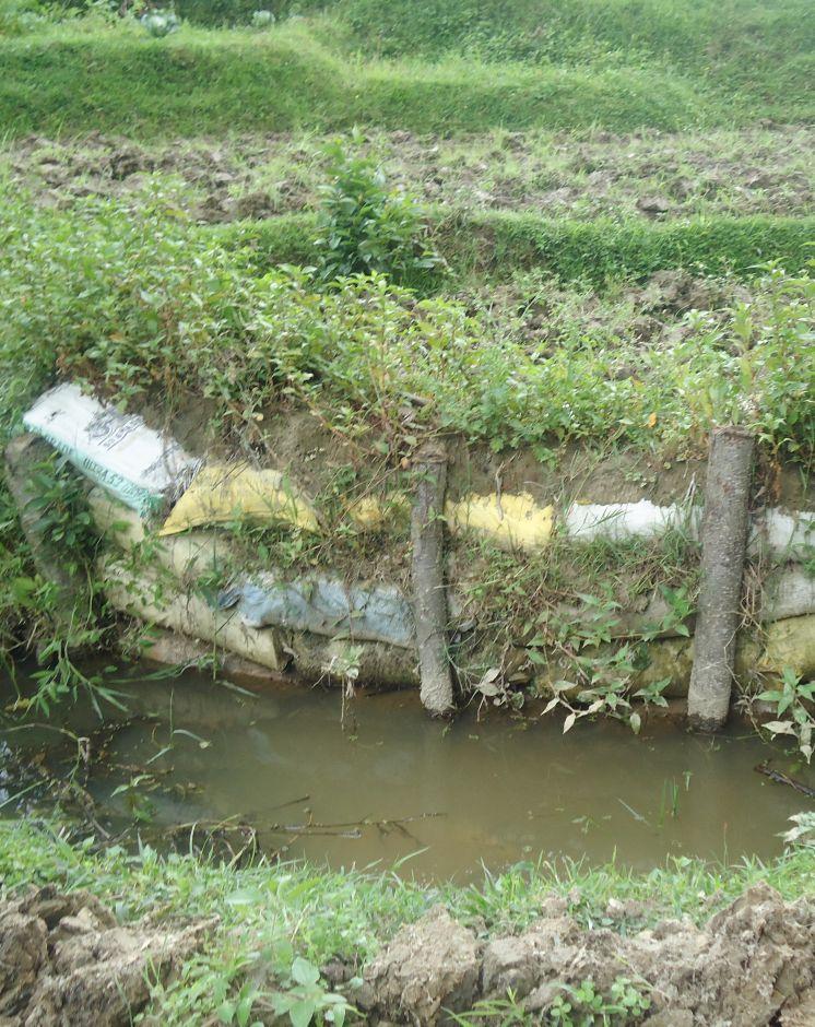
For more than two centuries, local farmers have promoted soil and water conservation by protecting the gullies which occur naturally between rice terraces; thus the land area is called ‘jagidol’ (jagi=rice, dol=gully). The small perennial streams which flow through the terraces are protected by constructing check dams and retaining walls to reduce the danger of erosion and collapse.
Purpose of the Technology: During the monsoon, the channels or trenches can become engorged and, since their walls are not reinforced (except for grass planted at the edges), the conduits can be easily eroded. When the erosion is severe enough, the edges of the terraces adjacent to the gullies can collapse. When many gullies collapse at once, the stability of the entire hillside is threatened with catastrophic consequences for the village situated above the planting area. Villagers have traditionally used local materials and expertise to maintain the gullies and reduce soil erosion by building retaining walls across the slope which are strengthened through plantation. The retaining walls are bio-engineered using a combination of bamboo poles, rocks, and soil-filled sacks. Bamboo poles are used for the backbone of the support structure, and rocks and soil-filled sacks are used to line the sides of the channel. Local grasses such as 'sitto' are planted on the top and, as they grow, their roots help to anchor the structure. When the channels are fortified by retaining walls and planting, they become entrenched and, over time, less maintenance is required. As a bonus, when the plants grown along the gullies mature, they provide biomass for the farm and fodder for cattle. During winter, when water is scarce, farmers modify the gully system by constructing check dams which can be used to collect water in one place. These dams are useful for irrigation during the dry season and they also help to prevent bed scouring.
2.3 Photos of the Technology
Media Gallery
2.5 Country/ region/ locations where the Technology has been applied and which are covered by this assessment
Country:
Nepal
Further specification of location:
Sharada Batase VDC, Kabhrepalanchok District
Specify the spread of the Technology:
- applied at specific points/ concentrated on a small area
Comments:
Total area covered by the SLM Technology is 1.1 km2.
Map
×2.6 Date of implementation
If precise year is not known, indicate approximate date:
- more than 50 years ago (traditional)
2.7 Introduction of the Technology
Specify how the Technology was introduced:
- as part of a traditional system (> 50 years)
3. Classification of the SLM Technology
3.1 Main purpose(s) of the Technology
- reduce risk of disasters
3.2 Current land use type(s) where the Technology is applied

Cropland
- Annual cropping
Number of growing seasons per year:
- 2
Specify:
Longest growing period in days: 200; Longest growing period from month to month: March-september; Second longest growing period in days: 120; Second longest growing period from month to month: October-January

Forest/ woodlands
Products and services:
- Timber
- Fuelwood
- Fodder

Waterways, waterbodies, wetlands
- Drainage lines, waterways
Comments:
Major land use problems (compiler’s opinion): As the land is continuously eroded, both farmland and inhabited areas will slowly slide downhill.
Forest products and services: timber, fuelwood
Other forest products and services: Fodder
Constraints of wastelands / deserts / glaciers / swamps
Livestock density: < 1 LU/km2
3.4 Water supply
Water supply for the land on which the Technology is applied:
- mixed rainfed-irrigated
3.5 SLM group to which the Technology belongs
- cross-slope measure
- water diversion and drainage
3.6 SLM measures comprising the Technology

vegetative measures
- V2: Grasses and perennial herbaceous plants

structural measures
- S5: Dams, pans, ponds
3.7 Main types of land degradation addressed by the Technology

soil erosion by water
- Wg: gully erosion/ gullying
Comments:
Main causes of degradation: crop management (annual, perennial, tree/shrub), deforestation / removal of natural vegetation (incl. forest fires), over-exploitation of vegetation for domestic use
3.8 Prevention, reduction, or restoration of land degradation
Specify the goal of the Technology with regard to land degradation:
- reduce land degradation
4. Technical specifications, implementation activities, inputs, and costs
4.1 Technical drawing of the Technology
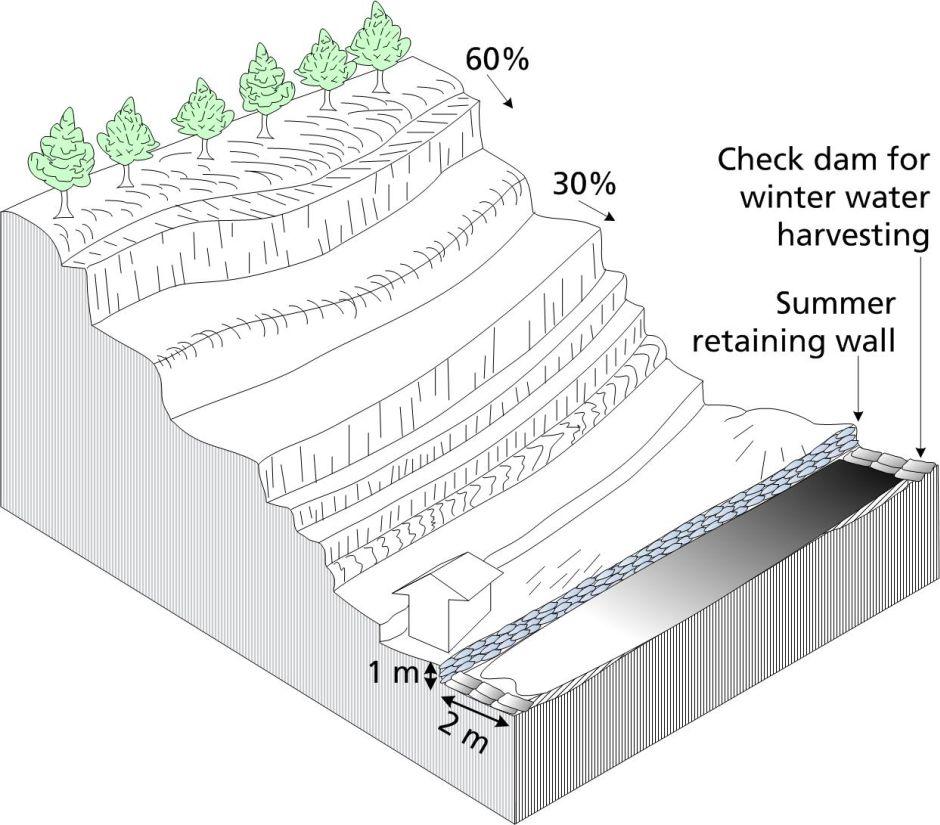
Technical specifications (related to technical drawing):
A jagidol area showing the approximate slope, bench terraces, and basic geometry of the landscape. With the shrine shown as in the photograph of the site.
Technical knowledge required for land users: moderate
Main technical functions: control of concentrated runoff: drain / divert, stabilisation of soil (eg by tree roots against land slides), water harvesting / increase water supply
Secondary technical functions: improvement of ground cover, spatial arrangement and diversification of land use
Author:
Duncan Scott, A. K. Thaku
4.2 General information regarding the calculation of inputs and costs
Specify how costs and inputs were calculated:
- per Technology area
Indicate size and area unit:
sq km
Specify currency used for cost calculations:
- USD
Indicate average wage cost of hired labour per day:
4.50
4.3 Establishment activities
| Activity | Timing (season) | |
|---|---|---|
| 1. | Local grasses such as utis, sito, amrisho, daleghas, and bamboo, can be planted on top of the reinforcements. | |
| 2. | Construction of dam with mud-filled sacks Construction of stone dam and spillways• Construction of retaining wall• Construction of bunds and barrier |
4.4 Costs and inputs needed for establishment
| Specify input | Unit | Quantity | Costs per Unit | Total costs per input | % of costs borne by land users | |
|---|---|---|---|---|---|---|
| Labour | Plant grasses | persons/day/sq km | 150.0 | 4.5 | 675.0 | 100.0 |
| Equipment | Equipment | sq km | 1.0 | 225.0 | 225.0 | 100.0 |
| Construction material | Material | sq km | 1.0 | 725.0 | 725.0 | 100.0 |
| Total costs for establishment of the Technology | 1625.0 | |||||
| Total costs for establishment of the Technology in USD | 1625.0 | |||||
4.5 Maintenance/ recurrent activities
| Activity | Timing/ frequency | |
|---|---|---|
| 1. | Continue to reinforce by planting with local grasses or bamboo on top of the structures until the plantings are well established. |
4.6 Costs and inputs needed for maintenance/ recurrent activities (per year)
| Specify input | Unit | Quantity | Costs per Unit | Total costs per input | % of costs borne by land users | |
|---|---|---|---|---|---|---|
| Labour | Reinforce by planting on structure | persons/day/sq km | 50.0 | 5.0 | 250.0 | 100.0 |
| Equipment | Equipment | sq km | 1.0 | 70.0 | 70.0 | 100.0 |
| Construction material | Material | sq km | 1.0 | 350.0 | 350.0 | 100.0 |
| Total costs for maintenance of the Technology | 670.0 | |||||
| Total costs for maintenance of the Technology in USD | 670.0 | |||||
4.7 Most important factors affecting the costs
Describe the most determinate factors affecting the costs:
The construction and maintenance of gullies demands attention during a busy agricultural calendar and can significantly add to the labour costs depending on the size and number of gullies and dams that need to be constructed and maintained.
5. Natural and human environment
5.1 Climate
Annual rainfall
- < 250 mm
- 251-500 mm
- 501-750 mm
- 751-1,000 mm
- 1,001-1,500 mm
- 1,501-2,000 mm
- 2,001-3,000 mm
- 3,001-4,000 mm
- > 4,000 mm
Agro-climatic zone
- sub-humid
Thermal climate class: subtropics
5.2 Topography
Slopes on average:
- flat (0-2%)
- gentle (3-5%)
- moderate (6-10%)
- rolling (11-15%)
- hilly (16-30%)
- steep (31-60%)
- very steep (>60%)
Landforms:
- plateau/plains
- ridges
- mountain slopes
- hill slopes
- footslopes
- valley floors
Altitudinal zone:
- 0-100 m a.s.l.
- 101-500 m a.s.l.
- 501-1,000 m a.s.l.
- 1,001-1,500 m a.s.l.
- 1,501-2,000 m a.s.l.
- 2,001-2,500 m a.s.l.
- 2,501-3,000 m a.s.l.
- 3,001-4,000 m a.s.l.
- > 4,000 m a.s.l.
5.3 Soils
Soil depth on average:
- very shallow (0-20 cm)
- shallow (21-50 cm)
- moderately deep (51-80 cm)
- deep (81-120 cm)
- very deep (> 120 cm)
Soil texture (topsoil):
- fine/ heavy (clay)
Topsoil organic matter:
- high (>3%)
If available, attach full soil description or specify the available information, e.g. soil type, soil PH/ acidity, Cation Exchange Capacity, nitrogen, salinity etc.
Soil fertility is high
Soil drainage / infiltration is poor
Soil water storage capacity is medium
5.4 Water availability and quality
Ground water table:
5-50 m
Availability of surface water:
excess
Water quality (untreated):
poor drinking water (treatment required)
Comments and further specifications on water quality and quantity:
Water quality (untreated): Also for agricultural use only (irrigation)
Availability of surface water: During Monsoon
5.5 Biodiversity
Species diversity:
- high
5.6 Characteristics of land users applying the Technology
Market orientation of production system:
- subsistence (self-supply)
Off-farm income:
- > 50% of all income
Relative level of wealth:
- average
Individuals or groups:
- individual/ household
Level of mechanization:
- manual work
- animal traction
Gender:
- women
- men
Indicate other relevant characteristics of the land users:
Land users applying the Technology are mainly common / average land users
Population density: 10-50 persons/km2
Annual population growth: 0.5% - 1%
90% of the land users are average wealthy.
5.7 Average area of land used by land users applying the Technology
- < 0.5 ha
- 0.5-1 ha
- 1-2 ha
- 2-5 ha
- 5-15 ha
- 15-50 ha
- 50-100 ha
- 100-500 ha
- 500-1,000 ha
- 1,000-10,000 ha
- > 10,000 ha
Is this considered small-, medium- or large-scale (referring to local context)?
- small-scale
5.8 Land ownership, land use rights, and water use rights
Land ownership:
- communal/ village
- individual, titled
Land use rights:
- individual
Water use rights:
- open access (unorganized)
5.9 Access to services and infrastructure
health:
- poor
- moderate
- good
education:
- poor
- moderate
- good
technical assistance:
- poor
- moderate
- good
employment (e.g. off-farm):
- poor
- moderate
- good
markets:
- poor
- moderate
- good
energy:
- poor
- moderate
- good
roads and transport:
- poor
- moderate
- good
drinking water and sanitation:
- poor
- moderate
- good
financial services:
- poor
- moderate
- good
6. Impacts and concluding statements
6.1 On-site impacts the Technology has shown
Socio-economic impacts
Production
crop production
fodder production
risk of production failure
production area
Comments/ specify:
reduce risk of land degredation
Water availability and quality
irrigation water availability
Income and costs
workload
Socio-cultural impacts
cultural opportunities
conflict mitigation
agricultural benefits the whole community at many different levels including social-cultural
livelihood and human well-being
Comments/ specify:
improved agriculture leads to food sufficiency, enhanced economic conditions, and better health throughout the community. When households have more cash income they usually invest it in education for their children
Ecological impacts
Water cycle/ runoff
water quantity
surface runoff
Soil
soil loss
Biodiversity: vegetation, animals
biomass/ above ground C
habitat diversity
pest/ disease control
Climate and disaster risk reduction
flood impacts
drought impacts
impacts of cyclones, rain storms
Other ecological impacts
competition for water, sunlight and nutrients
6.2 Off-site impacts the Technology has shown
downstream flooding
Downstream Neighbor field also benefit from slop stability and soil conservation
6.3 Exposure and sensitivity of the Technology to gradual climate change and climate-related extremes/ disasters (as perceived by land users)
Gradual climate change
Gradual climate change
| Season | increase or decrease | How does the Technology cope with it? | |
|---|---|---|---|
| annual temperature | increase | well |
Climate-related extremes (disasters)
Meteorological disasters
| How does the Technology cope with it? | |
|---|---|
| local rainstorm | not well |
6.4 Cost-benefit analysis
How do the benefits compare with the establishment costs (from land users’ perspective)?
Short-term returns:
positive
Long-term returns:
very positive
How do the benefits compare with the maintenance/ recurrent costs (from land users' perspective)?
Short-term returns:
very positive
Long-term returns:
very positive
6.5 Adoption of the Technology
Comments:
There is a moderate trend towards spontaneous adoption of the Technology
Comments on adoption trend: Communities throughout the area have adopted these structural measures for centuries without any external support. Communities downstream are beginning to see the benefits and they are also starting to adopt these measures.
6.7 Strengths/ advantages/ opportunities of the Technology
| Strengths/ advantages/ opportunities in the compiler’s or other key resource person’s view |
|---|
|
This is a well-accepted local practice. How can they be sustained / enhanced? Continue to implement this soil conservation measure. |
|
The use of mud-filled sacs is a recent innovation. How can they be sustained / enhanced? Some advance training may be needed. |
|
Reduced risk of losing crops and agricultural land because of soil degradation. How can they be sustained / enhanced? Continue to add to mud-based structures by vegetative means. |
|
An added benefit is the production of biomass: grass, fodder for animals, wood, and fuelwood. How can they be sustained / enhanced? Continue to plant more trees. |
|
Makes water available for irrigation even during the dry season. How can they be sustained / enhanced? Encourage more check dam construction along the gully. |
6.8 Weaknesses/ disadvantages/ risks of the Technology and ways of overcoming them
| Weaknesses/ disadvantages/ risks in the compiler’s or other key resource person’s view | How can they be overcome? |
|---|---|
| The traditional materials used in the construction of dams and gullies are prone to damage during flood events | The technology can be enhanced by the use of better materials and technical support. With research and funding, more robust conservation measures can be implemented. |
| In recent times, new activities such as brick making are coming to the villages; the entrepreneurs involved in these activities do not know about (and are not interested in) soil conservation measures | Increase awareness among newcomers. |
| There has never been any external support for these soil conservation activities even if downstream communities also benefit | Increase awareness among downstream communities. Explore possibilities for external support for controlled gullying. |
7. References and links
7.1 Methods/ sources of information
Links and modules
Expand all Collapse allLinks
Community-based approach in Erosion Control [Azerbaijan]
The unsustainable use of pastures and forest areas leads to erosion, degradation, desertification and loss of biodiversity in high mountain areas of the South Caucasus. In the village Ehen in the Ismayilli district in Azerbaijan, a community-based approach for erosion control was developed in a participative way. Together with village …
- Compiler: Hanns Kirchmeir
Protected gullies – a traditional sustainable land management … [Nepal]
Protected gullying is a sustainable land management practice initiated and maintained by the traditional community approach; it is based on indigenous knowledge and uses only locally available materials.
- Compiler: Shreedip Sigdel
Modules
No modules