Riverbed farming [Nepal]
- Creation:
- Update:
- Compiler: Shreedip Sigdel
- Editor: –
- Reviewers: David Streiff, Alexandra Gavilano
Bagar Kheti (Main Contributors: Elam Plus and Hari Gurung, Helvetas Nepal)
technologies_1691 - Nepal
View sections
Expand all Collapse all1. General information
1.2 Contact details of resource persons and institutions involved in the assessment and documentation of the Technology
SLM specialist:
Plus Elam
Helvetas
SLM specialist:
Gurung Hari
Helvetas Nepal
Nepal
SLM specialist:
Merz Juerg
Helvetas Nepal
Switzerland
Name of the institution(s) which facilitated the documentation/ evaluation of the Technology (if relevant)
ICIMOD International Centre for Integrated Mountain Development (ICIMOD) - NepalName of the institution(s) which facilitated the documentation/ evaluation of the Technology (if relevant)
HELVETAS (Swiss Intercooperation)1.3 Conditions regarding the use of data documented through WOCAT
The compiler and key resource person(s) accept the conditions regarding the use of data documented through WOCAT:
Yes
1.5 Reference to Questionnaire(s) on SLM Approaches (documented using WOCAT)
Land distribution and allocation for riverbed farming [Nepal]
Riverbed farming provides landless and land-poor households with the possibility to earn an income from on-farm activities close to home
- Compiler: Shreedip Sigdel
2. Description of the SLM Technology
2.1 Short description of the Technology
Definition of the Technology:
Riverbed farming can be used to increase household income and to improve the food security of landless and land-poor households in the Terai area of Nepal.
2.2 Detailed description of the Technology
Description:
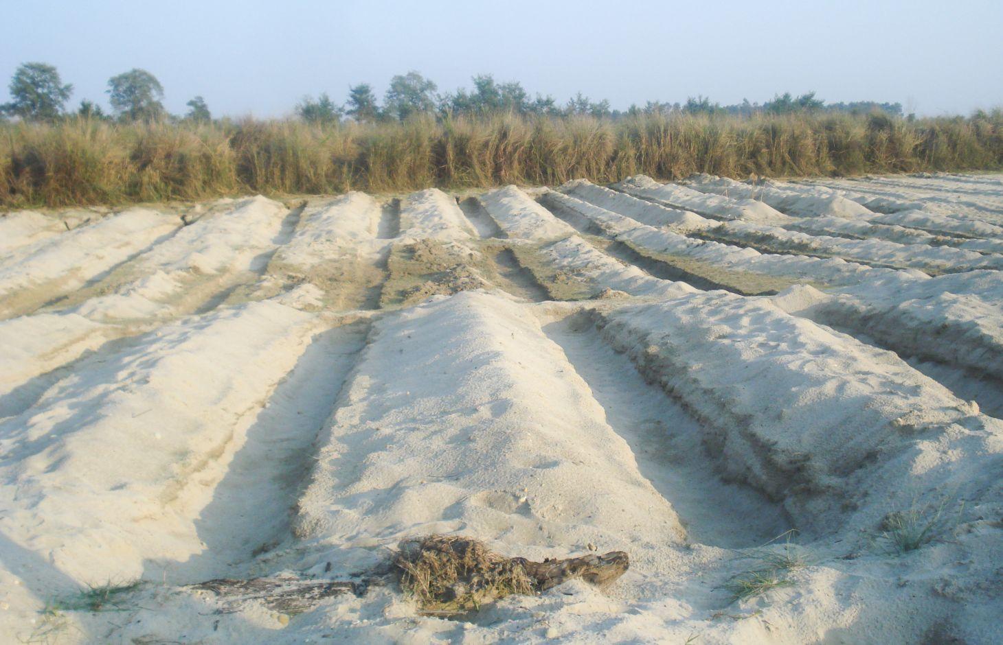
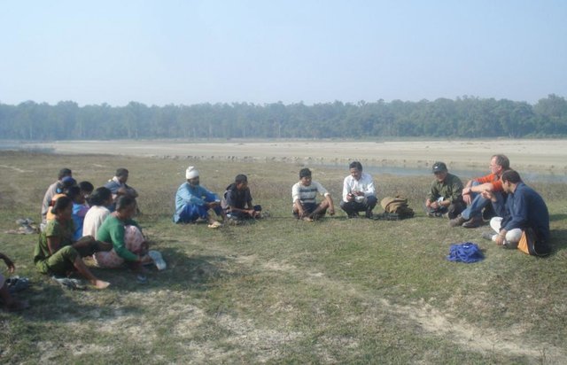
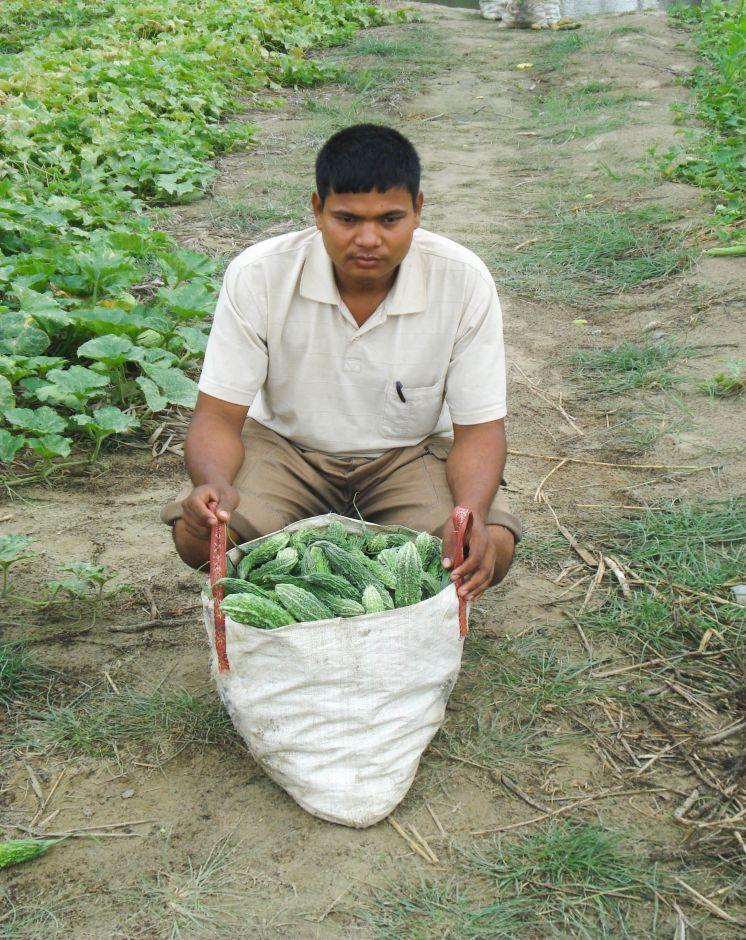
It is estimated that about 8,000 hectares of riverbed land would be suitable for agricultural cultivation in the Kailali and Kanchanpur Districts in the Western Terai areas of Nepal. After the river water recedes in the post-monsoon season, vegetables are planted in ditches dug into the seasonal sand banks; the crops are harvested before the onset of the next monsoon. In 2006, Elam Plus of HELVETAS Swiss Inter-cooperation Nepal, assessed local practices of riverbed farming and piloted an improved approach with 670 farmers, mostly from the indigenous Tharu community. During the first year they cultivated 43 hectares. Since the initial results indicated that riverbed farming could increase the target population’s income significantly, the programme was expanded from the initial two districts (Kailali and Kanchanpur) to two new districts (Banke, and Bardiya). The number of households was increased to 2000 in 2008 and 3165 in 2012 after the initiative won a Global Development Market Place award from the World Bank.
Establishment / maintenance activities and inputs: Requirements for riverbed farming:
• On average, the water table should not be lower than 1 m; when the water table is lower than this, too much labour is required.
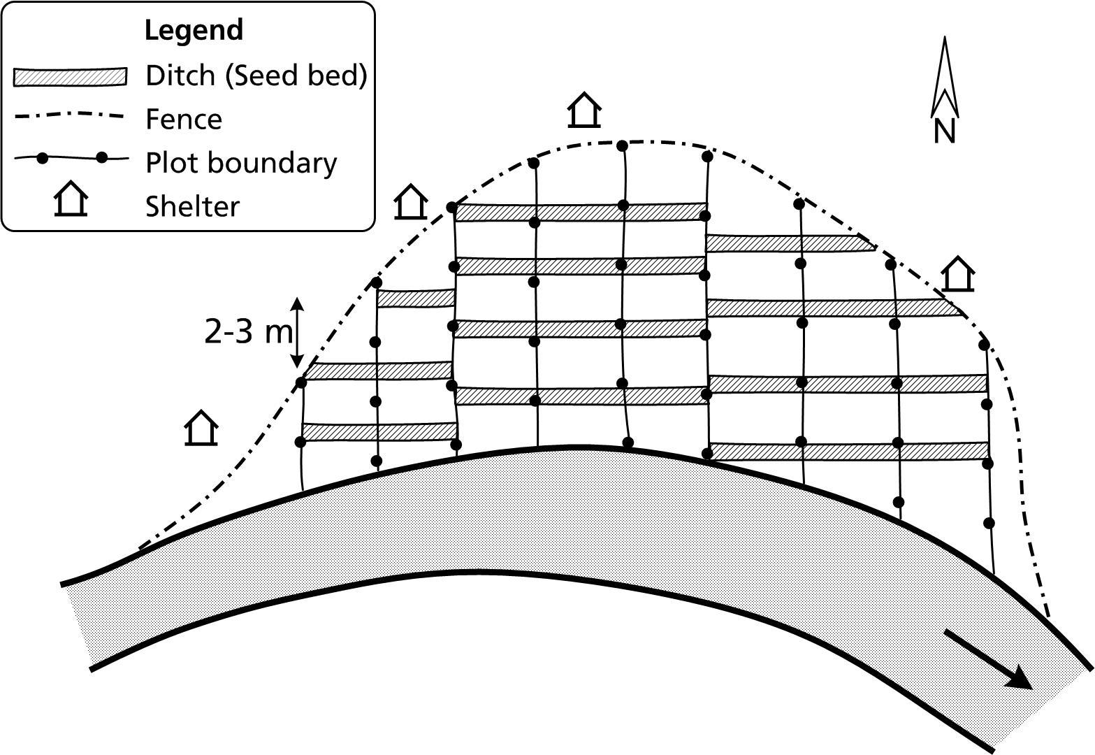
• Plots are allocated perpendicular to the river flow in order to give each farmer access to a variety of land types (and moisture levels) suitable for different crops.
• Ditches are up to 1 m deep and 1 m wide. The length depends on how much land is available.
• A row-to-row spacing of 2–3 m (between the ditches) and plant-to-plant spacing of 0.5–1 m is required depending on the crop.
• The ditches are dug in an east-west orientation to maximize the amount of sunshine they receive and to minimise the collection of sand carried by the prevailing winds.
• Riverbed farmers can build shelters close to their plots so that they can be close at hand to fend off thieves and wild animals.
2.3 Photos of the Technology
Media Gallery
2.5 Country/ region/ locations where the Technology has been applied and which are covered by this assessment
Country:
Nepal
Further specification of location:
Kanchanpur, Kailali Districts
Specify the spread of the Technology:
- evenly spread over an area
If the Technology is evenly spread over an area, specify area covered (in km2):
4.0
Comments:
Total area covered by the SLM Technology is 4 km2.
2.7 Introduction of the Technology
Specify how the Technology was introduced:
- through projects/ external interventions
3. Classification of the SLM Technology
3.1 Main purpose(s) of the Technology
- create beneficial economic impact
- create beneficial social impact
3.2 Current land use type(s) where the Technology is applied

Cropland
- Annual cropping
Annual cropping - Specify crops:
- vegetables - other
Number of growing seasons per year:
- 1
Specify:
Longest growing period from month to month: November to May
Comments:
Major land use problems (compiler’s opinion): Rivers in the Terai region change their course frequently and when they do, the adjacent lands are flooded. The riverbeds are flooded annually, while the riverbanks are only flooded during extreme events. The annually flooded riverbeds are seasonally dry (from September to May) and are a generally unused land resource. Landless and land- poor farmers can use this land to cultivate seasonal vegetables that are adapted to the environmental conditions prevalent on riverbeds.
3.5 SLM group to which the Technology belongs
- improved ground/ vegetation cover
- use different type of land for cultivation
3.6 SLM measures comprising the Technology

agronomic measures
- A2: Organic matter/ soil fertility

structural measures
- S3: Graded ditches, channels, waterways
3.7 Main types of land degradation addressed by the Technology

soil erosion by water
- Wr: riverbank erosion
Comments:
Main causes of degradation: floods
3.8 Prevention, reduction, or restoration of land degradation
Specify the goal of the Technology with regard to land degradation:
- reduce land degradation
4. Technical specifications, implementation activities, inputs, and costs
4.1 Technical drawing of the Technology
Technical specifications (related to technical drawing):
Plots for riverbed farming are allocated perpendicular to the river flow and the ditches are dug in an east-west orientation.
Technical knowledge required for land users: moderate
Main technical functions: increase / maintain water stored in soil, Support Income Generation
Secondary technical functions: improvement of ground cover, increase in organic matter, Stabilizes the soil
Author:
J Merz, AK Thaku
4.2 General information regarding the calculation of inputs and costs
Specify how costs and inputs were calculated:
- per Technology area
Indicate size and area unit:
ha
Specify currency used for cost calculations:
- USD
4.3 Establishment activities
| Activity | Timing (season) | |
|---|---|---|
| 1. | Dig ditches in an east-west direction about 2 to 3 m apart. The ditches can be up to 1 m deep and 1 m wide; the length will depend on the shape of the land. | |
| 2. | Apply fertilizer: farmyard manure/compost about 12 tonnes; urea about 100 kg; di-ammonium phosphate (DAP) about 120 kg; and potash about 30 kg per ha. | |
| 3. | Plant seeds/seedlings using the appropriate row-to-row (RXR) and plant-to-plant (PXP) distance for at least one crop. A row-to-row distance of 3 m is required for bottle gourd, pumpkin, and water melon and 2 m for bitter gourd and cucumber; a plant-to-plant distance of 0.5 m is needed for cucumber and bitter gourd and 1 m for water melon, bottle gourd, and pumpkin. |
4.4 Costs and inputs needed for establishment
| Specify input | Unit | Quantity | Costs per Unit | Total costs per input | % of costs borne by land users | |
|---|---|---|---|---|---|---|
| Labour | Dig ditches and applying fertilizer and manure | ha | 1.0 | 232.0 | 232.0 | 100.0 |
| Equipment | Sprayer, watering cans,spade | ha | 1.0 | 42.0 | 42.0 | |
| Fertilizers and biocides | Seeds, chemical fertilizer | ha | 1.0 | 267.0 | 267.0 | |
| Construction material | Plastic bags,mulching material | ha | 1.0 | 21.0 | 21.0 | |
| Total costs for establishment of the Technology | 562.0 | |||||
| Total costs for establishment of the Technology in USD | 562.0 | |||||
4.5 Maintenance/ recurrent activities
| Activity | Timing/ frequency | |
|---|---|---|
| 1. | Water new plots every 2 to 3 days; as the seedlings mature, water weekly or as needed depending on the weather and the soilconditions. | |
| 2. | Replace seedlings that have died and replant seeds in places where they have not germinated | |
| 3. | Top dress with nitrogen, phosphorous, potassium | |
| 4. | Mulch with straw and grass | |
| 5. | Weed and protect plants as needed | |
| 6. | Protect the riverbed areas throughout the growing season as they are prone to attacks by thieves and wild animals, mainly jackals and monkeys. However, note that the reported losses to date have been very minimal. |
4.6 Costs and inputs needed for maintenance/ recurrent activities (per year)
| Specify input | Unit | Quantity | Costs per Unit | Total costs per input | % of costs borne by land users | |
|---|---|---|---|---|---|---|
| Labour | Maintaining plots | ha | 1.0 | 42.0 | 42.0 | 100.0 |
| Equipment | Sprayer, watering cans,spade | ha | 1.0 | 28.0 | 28.0 | 25.0 |
| Fertilizers and biocides | Seeds, chemical fertilizer | ha | 1.0 | 84.0 | 84.0 | 25.0 |
| Construction material | Plastic bags, mulching material | ha | 1.0 | 11.0 | 11.0 | 50.0 |
| Total costs for maintenance of the Technology | 165.0 | |||||
| Total costs for maintenance of the Technology in USD | 165.0 | |||||
4.7 Most important factors affecting the costs
Describe the most determinate factors affecting the costs:
All costs and amounts are rough estimates by the technicians and authors.
5. Natural and human environment
5.1 Climate
Annual rainfall
- < 250 mm
- 251-500 mm
- 501-750 mm
- 751-1,000 mm
- 1,001-1,500 mm
- 1,501-2,000 mm
- 2,001-3,000 mm
- 3,001-4,000 mm
- > 4,000 mm
Agro-climatic zone
- humid
Thermal climate class: subtropics
5.2 Topography
Slopes on average:
- flat (0-2%)
- gentle (3-5%)
- moderate (6-10%)
- rolling (11-15%)
- hilly (16-30%)
- steep (31-60%)
- very steep (>60%)
Landforms:
- plateau/plains
- ridges
- mountain slopes
- hill slopes
- footslopes
- valley floors
Altitudinal zone:
- 0-100 m a.s.l.
- 101-500 m a.s.l.
- 501-1,000 m a.s.l.
- 1,001-1,500 m a.s.l.
- 1,501-2,000 m a.s.l.
- 2,001-2,500 m a.s.l.
- 2,501-3,000 m a.s.l.
- 3,001-4,000 m a.s.l.
- > 4,000 m a.s.l.
5.3 Soils
Soil depth on average:
- very shallow (0-20 cm)
- shallow (21-50 cm)
- moderately deep (51-80 cm)
- deep (81-120 cm)
- very deep (> 120 cm)
Soil texture (topsoil):
- coarse/ light (sandy)
Topsoil organic matter:
- low (<1%)
If available, attach full soil description or specify the available information, e.g. soil type, soil PH/ acidity, Cation Exchange Capacity, nitrogen, salinity etc.
Soil fertility is medium
Soil drainage / infiltration is good
Soil water storage capacity is low
5.4 Water availability and quality
Ground water table:
5-50 m
Availability of surface water:
poor/ none
Water quality (untreated):
good drinking water
Comments and further specifications on water quality and quantity:
Ground water table: 30-50 m
5.5 Biodiversity
Species diversity:
- low
5.6 Characteristics of land users applying the Technology
Market orientation of production system:
- mixed (subsistence/ commercial)
Off-farm income:
- > 50% of all income
Relative level of wealth:
- poor
Individuals or groups:
- individual/ household
Indicate other relevant characteristics of the land users:
Population density: 200-500 persons/km2
5.7 Average area of land used by land users applying the Technology
- < 0.5 ha
- 0.5-1 ha
- 1-2 ha
- 2-5 ha
- 5-15 ha
- 15-50 ha
- 50-100 ha
- 100-500 ha
- 500-1,000 ha
- 1,000-10,000 ha
- > 10,000 ha
5.8 Land ownership, land use rights, and water use rights
- landless
5.9 Access to services and infrastructure
health:
- poor
- moderate
- good
education:
- poor
- moderate
- good
technical assistance:
- poor
- moderate
- good
employment (e.g. off-farm):
- poor
- moderate
- good
markets:
- poor
- moderate
- good
energy:
- poor
- moderate
- good
roads and transport:
- poor
- moderate
- good
drinking water and sanitation:
- poor
- moderate
- good
financial services:
- poor
- moderate
- good
6. Impacts and concluding statements
6.1 On-site impacts the Technology has shown
Socio-economic impacts
Income and costs
farm income
diversity of income sources
Comments/ specify:
Provides vegetables for riverbed farming households
Other socio-economic impacts
dependent on external agricultural inputs
Socio-cultural impacts
food security/ self-sufficiency
Comments/ specify:
Riverbed crops can be exchanged for food grain; on average,this can provide an additional four month
conflict mitigation
Comments/ specify:
Conflicts can arise when the land is being allocated and border conflict can arise between different groups
situation of socially and economically disadvantaged groups
Comments/ specify:
Additional income can be used to cover school fees and health services
livelihood and human well-being
Comments/ specify:
Provides alternative means of income as well as food security for landless and land-poor households
social status of local resource persons
need for income usually met by migration and by off-farm daily wage labour
Ecological impacts
Water cycle/ runoff
water quality
Comments/ specify:
Excessive use of fertilizers may affect water quality and the use of pesticides in the case of massive pest invasions may affect the water quality as well
Soil
soil cover
soil loss
Comments/ specify:
Minimize soil loss due to wind erosion
Climate and disaster risk reduction
flood impacts
Comments/ specify:
Crops can be lost during floods, cold spells and hailstormes
6.2 Off-site impacts the Technology has shown
Local availability of fresh vegetables
6.3 Exposure and sensitivity of the Technology to gradual climate change and climate-related extremes/ disasters (as perceived by land users)
Gradual climate change
Gradual climate change
| Season | increase or decrease | How does the Technology cope with it? | |
|---|---|---|---|
| annual temperature | increase | well |
Climate-related extremes (disasters)
Hydrological disasters
| How does the Technology cope with it? | |
|---|---|
| general (river) flood | not well |
6.4 Cost-benefit analysis
How do the benefits compare with the establishment costs (from land users’ perspective)?
Short-term returns:
positive
Long-term returns:
positive
How do the benefits compare with the maintenance/ recurrent costs (from land users' perspective)?
Short-term returns:
positive
Long-term returns:
positive
6.5 Adoption of the Technology
Comments:
There is a moderate trend towards spontaneous adoption of the Technology
Comments on adoption trend: The majority of riverbed farmers among the first few groups to learn the technique continued riverbed farming after support for the project ended. In the third year, 55 of the original 61 groups were still farming on the riverbed even though they did not receive any agricultural inputs with the exception of support from the local resource persons. The local resource persons have organized themselves into an independent organisation that now provides technical support through the Micro Enterprise Development Fund and through individual channels. Now that Nepali farmers have started to farm the riverbeds in the Kailali and Kanchanpur Districts, the number of Indian farmers who previously farmed these riverbeds has drastically diminished.
6.7 Strengths/ advantages/ opportunities of the Technology
| Strengths/ advantages/ opportunities in the compiler’s or other key resource person’s view |
|---|
|
Riverbed farming provides a new source of income for landless and land-poor households How can they be sustained / enhanced? Continue to provide technical support through local resource persons. These persons can be supported through district-based instruments such as the Micro Enterprise Development Fund. Local governing bodies such as the district development committees, municipalities, and village development committees, can support riverbed farming with their own funds; can support farmers with the land leasing process, can help to identify primary stakeholders, and can also help by promoting policies that are favourable towards riverbed farming. |
|
Riverbed farming has a very high cost-benefit ratio and a very low investment requirement. How can they be sustained / enhanced? Continue to promote this technology among primary stakeholders. |
|
All services including the supply of quality seeds, tools, and materials are now processed through the local agrovets and agricultural extension is available through local resource persons. These are locally available and of high quality. How can they be sustained / enhanced? Agrovets, local resource persons, and their associations may need further capacity building through different channels such as the Micro Enterprise Development Fund, and/or the District Agricultural Development Office |
6.8 Weaknesses/ disadvantages/ risks of the Technology and ways of overcoming them
| Weaknesses/ disadvantages/ risks in the compiler’s or other key resource person’s view | How can they be overcome? |
|---|---|
| Competition from riverbed products originating in India and a glut during the season | Riverbed farmer groups need to improve their understanding of the value chain and their access to markets. |
| Mineral fertilizer and biopesticides are now used to ensure a good harvest | Promote sustainable soil management practices including the use of farmyard manure, urine collection, and bio-pesticides |
| Land ownership of riverbed land is often contested | Long term leasehold agreements need to be negotiated with land owners |
7. References and links
7.1 Methods/ sources of information
7.2 References to available publications
Title, author, year, ISBN:
Riverbed farming manual and local resource person training modules. Kathmandu, Nepal, HELVETAS Swiss Intercooperation Nepal
Links and modules
Expand all Collapse allLinks
Land distribution and allocation for riverbed farming [Nepal]
Riverbed farming provides landless and land-poor households with the possibility to earn an income from on-farm activities close to home
- Compiler: Shreedip Sigdel
Modules
No modules