Soil erosion control by ridges [Greece]
- Creation:
- Update:
- Compiler: Costas Kosmas
- Editor: –
- Reviewers: Ursula Gaemperli, Gudrun Schwilch, Alexandra Gavilano
Καλλιέργεια αμπέλου σε μικρούς αναβαθμούς
technologies_2922 - Greece
View sections
Expand all Collapse all1. General information
1.2 Contact details of resource persons and institutions involved in the assessment and documentation of the Technology
Key resource person(s)
land user:
Kokolakakis Manolis
Greece
SLM specialist:
Name of project which facilitated the documentation/ evaluation of the Technology (if relevant)
Interactive Soil Quality assessment in Europe and China for Agricultural productivity and Environmental Resilience (EU-iSQAPER)Name of the institution(s) which facilitated the documentation/ evaluation of the Technology (if relevant)
Agricultural University of Athens (AUA) - Greece1.3 Conditions regarding the use of data documented through WOCAT
The compiler and key resource person(s) accept the conditions regarding the use of data documented through WOCAT:
Yes
1.4 Declaration on sustainability of the described Technology
Is the Technology described here problematic with regard to land degradation, so that it cannot be declared a sustainable land management technology?
No
2. Description of the SLM Technology
2.1 Short description of the Technology
Definition of the Technology:
The technology consists of shaping the land in small ridges followed an interspaced part in which the main cultivation work of the crop is carried out. Ridges are the place where the plants are growing.
2.2 Detailed description of the Technology
Description:
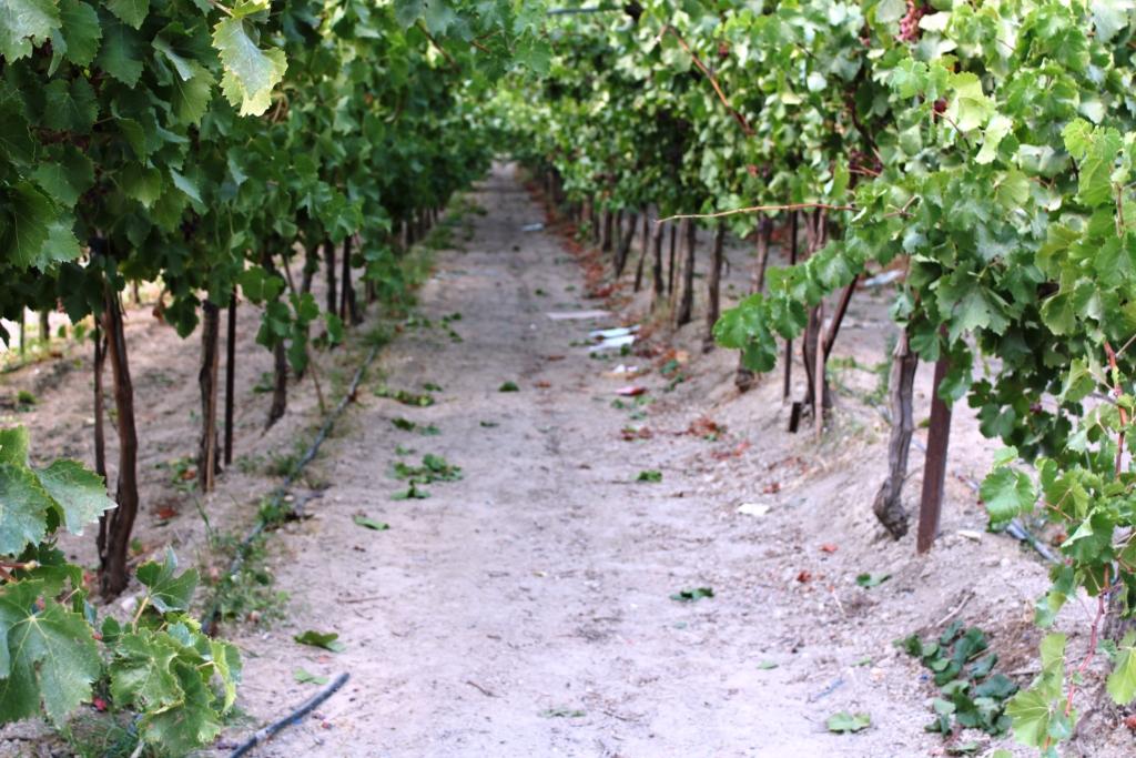
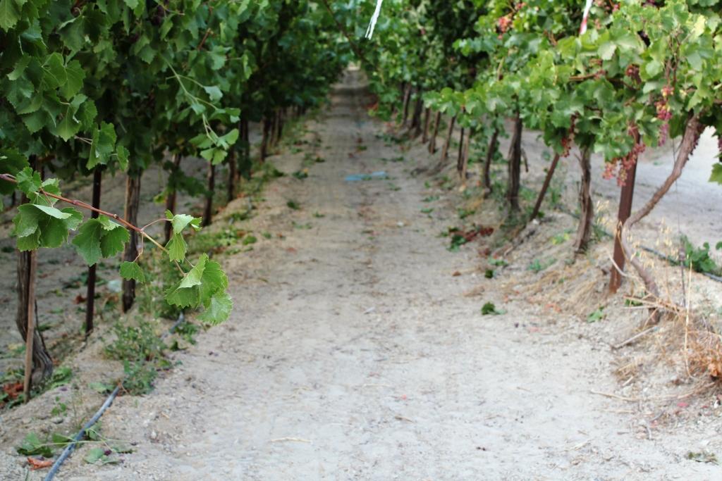
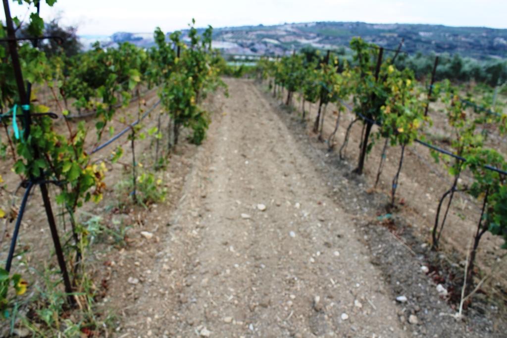
The technology is mainly applied in cultivated land, preferable in vineyards. The main characteristics are (a) shaping the land in ridges of about 25 cm high and 35 cm wide (b) leaving an interspaced part of the land of 200-220 cm. Ridges are the place where the plants are growing, while the interspaced part is used for carrying out all the necessary cultivation practices and harvesting of grapes. The purposes of the technology is to interrupt surface water runoff and to carry out easily the various cultivation works. It can be applied in a sloping land with slope gradient not higher than 12%. The major activities to establish the technology are to use a machine (a tractor) with the appropriate cultivation instrument (a plate) for shaping the land. The benefits of the technology are: (a) reduction in soil erosion, and (b) easily carrying out the various cultivation practices. The land users like it since their work is carrying out easily and store water runoff in the rootzone.
2.3 Photos of the Technology
Media Gallery
2.5 Country/ region/ locations where the Technology has been applied and which are covered by this assessment
Country:
Greece
Region/ State/ Province:
Crete
Further specification of location:
Heraklion perfecture
Specify the spread of the Technology:
- evenly spread over an area
If precise area is not known, indicate approximate area covered:
- < 0.1 km2 (10 ha)
Comments:
The technology can be applied in slightly to moderately sloping land (2-12% slope gradient)
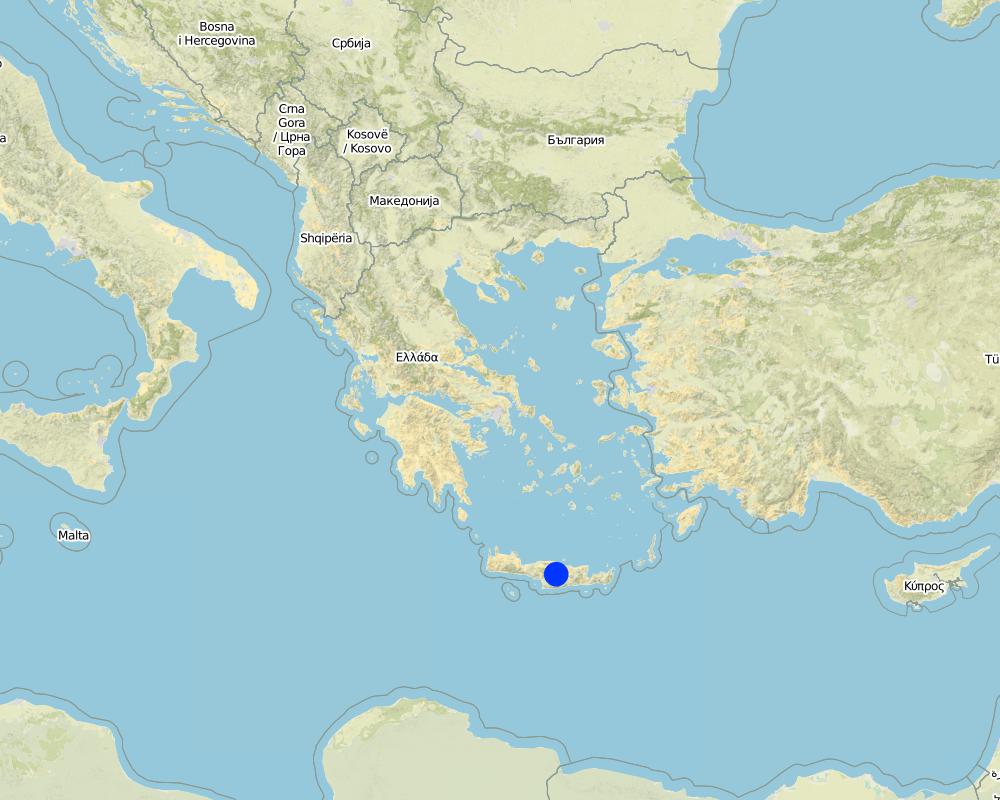
Map
×2.6 Date of implementation
If precise year is not known, indicate approximate date:
- 10-50 years ago
2.7 Introduction of the Technology
Specify how the Technology was introduced:
- through land users' innovation
3. Classification of the SLM Technology
3.1 Main purpose(s) of the Technology
- improve production
- reduce, prevent, restore land degradation
3.2 Current land use type(s) where the Technology is applied

Cropland
- Tree and shrub cropping
Tree and shrub cropping - Specify crops:
- grapes
Number of growing seasons per year:
- 1
Specify:
It is related to perennial crops
3.4 Water supply
Water supply for the land on which the Technology is applied:
- mixed rainfed-irrigated
Comments:
Irrigation water can be supplied during early spring or July-August when the climate is very dry
3.5 SLM group to which the Technology belongs
- cross-slope measure
- water harvesting
3.6 SLM measures comprising the Technology

structural measures
- S2: Bunds, banks
3.7 Main types of land degradation addressed by the Technology

soil erosion by water
- Wt: loss of topsoil/ surface erosion
3.8 Prevention, reduction, or restoration of land degradation
Specify the goal of the Technology with regard to land degradation:
- prevent land degradation
4. Technical specifications, implementation activities, inputs, and costs
4.1 Technical drawing of the Technology
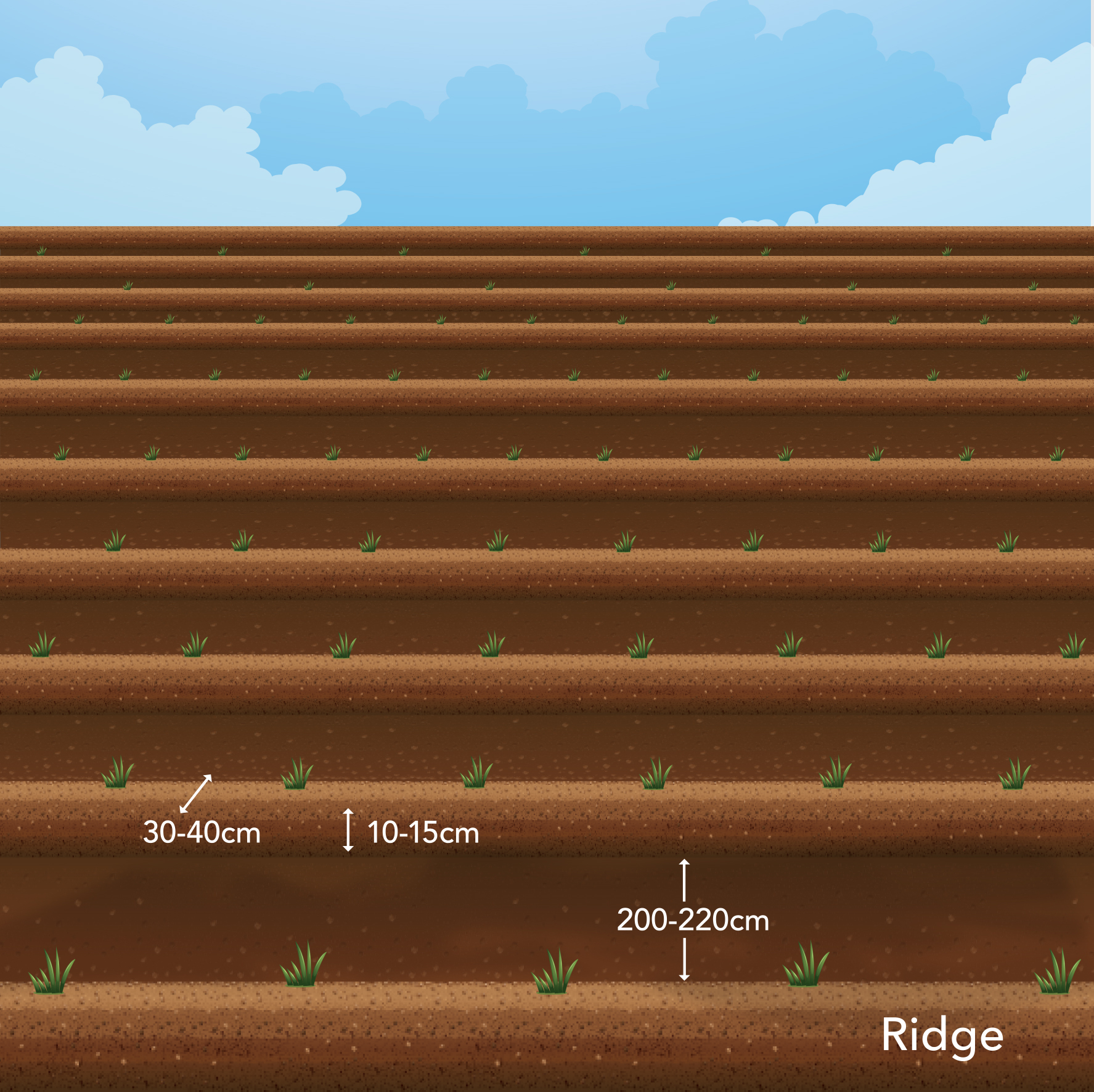
Technical specifications (related to technical drawing):
The ridges are shaped by a tractor using a plate with an angle of 30° with respect the line of cultivation. The shaped ridges have a width of about 25 cm and 35 cm and 10-15 cm high, leaving an interspaced part of the land of 200-220 cm. Ridges are the part of the land where plants are growing. The slope gradient can range from 2-12% or a little higher.
Author:
Costas Kosmas
Date:
4/9/2017
4.2 General information regarding the calculation of inputs and costs
Specify how costs and inputs were calculated:
- per Technology area
Indicate size and area unit:
1 h
Specify currency used for cost calculations:
- USD
Indicate average wage cost of hired labour per day:
40
4.3 Establishment activities
| Activity | Timing (season) | |
|---|---|---|
| 1. | Shaping the land | Winter-early spring |
| 2. | Planting | Winter-early spring |
4.4 Costs and inputs needed for establishment
| Specify input | Unit | Quantity | Costs per Unit | Total costs per input | % of costs borne by land users | |
|---|---|---|---|---|---|---|
| Labour | Clearing the land | person-days | 1.0 | 40.0 | 40.0 | 100.0 |
| Labour | Shaping of ridges | person-days | 0.5 | 40.0 | 20.0 | 100.0 |
| Equipment | Tractor including shaping instrument (plate) | machine hours | 1.0 | 70.0 | 70.0 | 100.0 |
| Total costs for establishment of the Technology | 130.0 | |||||
| Total costs for establishment of the Technology in USD | 130.0 | |||||
4.5 Maintenance/ recurrent activities
| Activity | Timing/ frequency | |
|---|---|---|
| 1. | Reshaping ridges | Winter-early spring |
4.6 Costs and inputs needed for maintenance/ recurrent activities (per year)
| Specify input | Unit | Quantity | Costs per Unit | Total costs per input | % of costs borne by land users | |
|---|---|---|---|---|---|---|
| Labour | Reshaping ridges by shovel | hours | 3.0 | 5.0 | 15.0 | 100.0 |
| Total costs for maintenance of the Technology | 15.0 | |||||
| Total costs for maintenance of the Technology in USD | 15.0 | |||||
4.7 Most important factors affecting the costs
Describe the most determinate factors affecting the costs:
Costs are affected mainly during installment (shaping the land and planting materials)
5. Natural and human environment
5.1 Climate
Annual rainfall
- < 250 mm
- 251-500 mm
- 501-750 mm
- 751-1,000 mm
- 1,001-1,500 mm
- 1,501-2,000 mm
- 2,001-3,000 mm
- 3,001-4,000 mm
- > 4,000 mm
Specify average annual rainfall (if known), in mm:
470.00
Specifications/ comments on rainfall:
Rainfall occurs mainly from October to May
Agro-climatic zone
- semi-arid
Mediterranean
5.2 Topography
Slopes on average:
- flat (0-2%)
- gentle (3-5%)
- moderate (6-10%)
- rolling (11-15%)
- hilly (16-30%)
- steep (31-60%)
- very steep (>60%)
Landforms:
- plateau/plains
- ridges
- mountain slopes
- hill slopes
- footslopes
- valley floors
Altitudinal zone:
- 0-100 m a.s.l.
- 101-500 m a.s.l.
- 501-1,000 m a.s.l.
- 1,001-1,500 m a.s.l.
- 1,501-2,000 m a.s.l.
- 2,001-2,500 m a.s.l.
- 2,501-3,000 m a.s.l.
- 3,001-4,000 m a.s.l.
- > 4,000 m a.s.l.
Indicate if the Technology is specifically applied in:
- not relevant
5.3 Soils
Soil depth on average:
- very shallow (0-20 cm)
- shallow (21-50 cm)
- moderately deep (51-80 cm)
- deep (81-120 cm)
- very deep (> 120 cm)
Soil texture (topsoil):
- medium (loamy, silty)
- fine/ heavy (clay)
Soil texture (> 20 cm below surface):
- medium (loamy, silty)
- fine/ heavy (clay)
Topsoil organic matter:
- high (>3%)
- medium (1-3%)
5.4 Water availability and quality
Ground water table:
5-50 m
Availability of surface water:
medium
Water quality (untreated):
for agricultural use only (irrigation)
Is water salinity a problem?
No
Is flooding of the area occurring?
No
5.5 Biodiversity
Species diversity:
- low
Habitat diversity:
- medium
5.6 Characteristics of land users applying the Technology
Sedentary or nomadic:
- Sedentary
Market orientation of production system:
- mixed (subsistence/ commercial)
Off-farm income:
- > 50% of all income
Relative level of wealth:
- average
Individuals or groups:
- individual/ household
Level of mechanization:
- mechanized/ motorized
Gender:
- men
Age of land users:
- youth
- middle-aged
5.7 Average area of land used by land users applying the Technology
- < 0.5 ha
- 0.5-1 ha
- 1-2 ha
- 2-5 ha
- 5-15 ha
- 15-50 ha
- 50-100 ha
- 100-500 ha
- 500-1,000 ha
- 1,000-10,000 ha
- > 10,000 ha
Is this considered small-, medium- or large-scale (referring to local context)?
- small-scale
5.8 Land ownership, land use rights, and water use rights
Land ownership:
- individual, titled
Land use rights:
- leased
Water use rights:
- leased
5.9 Access to services and infrastructure
health:
- poor
- moderate
- good
education:
- poor
- moderate
- good
technical assistance:
- poor
- moderate
- good
employment (e.g. off-farm):
- poor
- moderate
- good
markets:
- poor
- moderate
- good
energy:
- poor
- moderate
- good
roads and transport:
- poor
- moderate
- good
drinking water and sanitation:
- poor
- moderate
- good
financial services:
- poor
- moderate
- good
6. Impacts and concluding statements
6.1 On-site impacts the Technology has shown
Socio-economic impacts
Production
crop production
Quantity before SLM:
20-25 tn/ha
Quantity after SLM:
22-27.5 tn/ha
Water availability and quality
demand for irrigation water
Quantity before SLM:
-1
Quantity after SLM:
1
Ecological impacts
Water cycle/ runoff
harvesting/ collection of water
Quantity before SLM:
-1
Quantity after SLM:
2
surface runoff
Quantity before SLM:
-1
Quantity after SLM:
2
Soil
soil moisture
Comments/ specify:
Increase in soil moisture can not be quantified in percentage. It depends on the amount of rain water that will be stored into the soil by preventing runoff by existing ridges.
soil loss
Comments/ specify:
It can not be quantified. it depends on the amount of runoff water that will be generated.
6.2 Off-site impacts the Technology has shown
downstream flooding
Quantity before SLM:
-1
Quantity after SLM:
2
6.3 Exposure and sensitivity of the Technology to gradual climate change and climate-related extremes/ disasters (as perceived by land users)
Gradual climate change
Gradual climate change
| Season | increase or decrease | How does the Technology cope with it? | |
|---|---|---|---|
| annual temperature | increase | moderately | |
| annual rainfall | decrease | well |
6.4 Cost-benefit analysis
How do the benefits compare with the establishment costs (from land users’ perspective)?
Short-term returns:
slightly positive
Long-term returns:
positive
How do the benefits compare with the maintenance/ recurrent costs (from land users' perspective)?
Short-term returns:
neutral/ balanced
Long-term returns:
neutral/ balanced
6.5 Adoption of the Technology
- 1-10%
Of all those who have adopted the Technology, how many did so spontaneously, i.e. without receiving any material incentives/ payments?
- 91-100%
6.6 Adaptation
Has the Technology been modified recently to adapt to changing conditions?
No
6.7 Strengths/ advantages/ opportunities of the Technology
| Strengths/ advantages/ opportunities in the land user’s view |
|---|
| Increase in water storage and decrease in soil loss |
| Strengths/ advantages/ opportunities in the compiler’s or other key resource person’s view |
|---|
| Increase in water storage and decrease in soil loss |
6.8 Weaknesses/ disadvantages/ risks of the Technology and ways of overcoming them
| Weaknesses/ disadvantages/ risks in the land user’s view | How can they be overcome? |
|---|---|
| High erosion rates under heavy rainfall | covering the soil with a grass. |
| Weaknesses/ disadvantages/ risks in the compiler’s or other key resource person’s view | How can they be overcome? |
|---|---|
| Gully erosion under heavy rainfall | Cover grass |
7. References and links
7.1 Methods/ sources of information
- field visits, field surveys
5
- interviews with land users
2
When were the data compiled (in the field)?
09/09/2016
7.2 References to available publications
Title, author, year, ISBN:
No references
7.3 Links to relevant online information
Title/ description:
No references
Links and modules
Expand all Collapse allLinks
No links
Modules
No modules