Grassed waterways [Germany]
- Creation:
- Update:
- Compiler: Felix Witing
- Editors: Michael Strauch, Mona Pauer
- Reviewers: William Critchley, Rima Mekdaschi Studer
Dauerbegrünung erosionsgefährdeter Abflussbahnen
technologies_5935 - Germany
View sections
Expand all Collapse all1. General information
1.2 Contact details of resource persons and institutions involved in the assessment and documentation of the Technology
SLM specialist:
SLM specialist:
land user:
Farmer Local
Germany
Name of project which facilitated the documentation/ evaluation of the Technology (if relevant)
OPtimal strategies to retAIN and re-use water and nutrients in small agricultural catchments across different soil-climatic regions in Europe (OPTAIN)Name of the institution(s) which facilitated the documentation/ evaluation of the Technology (if relevant)
Helmholtz Centre for Environmental Research (UFZ) - Germany1.3 Conditions regarding the use of data documented through WOCAT
The compiler and key resource person(s) accept the conditions regarding the use of data documented through WOCAT:
Yes
1.4 Declaration on sustainability of the described Technology
Is the Technology described here problematic with regard to land degradation, so that it cannot be declared a sustainable land management technology?
No
2. Description of the SLM Technology
2.1 Short description of the Technology
Definition of the Technology:
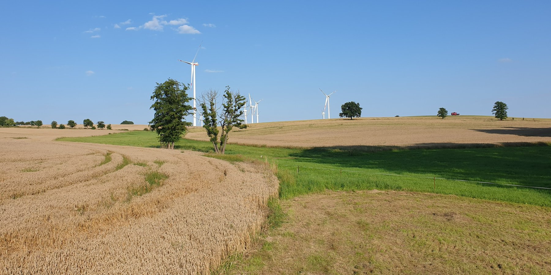
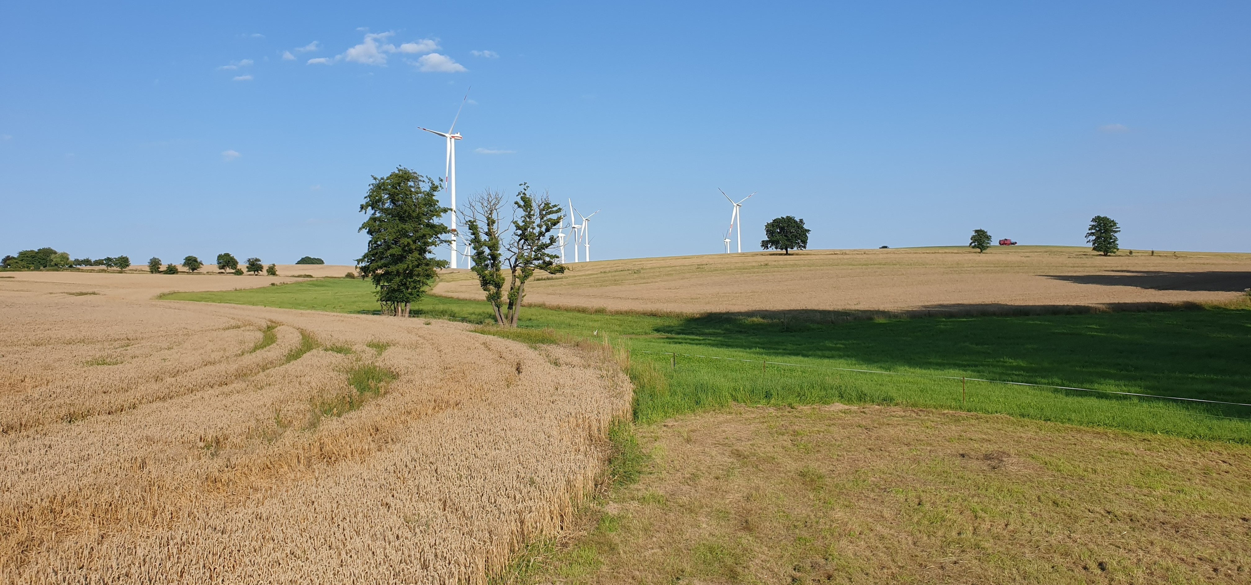
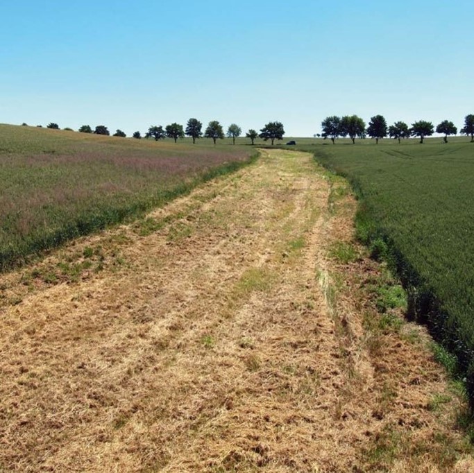
A grassed waterway is a strip of grass and other permanent low growing vegetation that is established along in the main drainage line (the thalweg) of an agricultural field to discharge water safely and prevent gully development.
2.2 Detailed description of the Technology
Description:
In order to prevent gully erosion along main drainage lines (thalwegs), grassed waterways, composed of grass and other permanent low growing vegetation, are established to discharge water safely. The grassed waterway slows down the surface runoff in the thalweg, increases infiltration and stabilizes the soil surface. This reduces soil erosion by water and the associated runoff of nutrients and pesticides. Fiener et al. (2005) reported a sediment retention of 80-95% and a water retention of 70-90%. Sediment is trapped mainly by water infiltration (infiltration-induced sedimentation) rather than by the filtering effect of vegetation. The conservation value of grassed waterways is not as high as for other measures, but they are still considered as a biotope network as well as a habitat for grassland breeders when extensive management practices are used (LfULG, 2010).
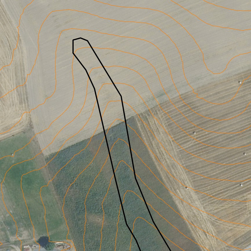
Grassed waterways are typically installed in relatively large arable fields. Normally only the most vulnerable lowest area of the field needs to be grassed. The width of the area to be grassed depends on the size of the drained catchment, the physiographic characteristics of the discharge pathway (channel shape, bottom slope) and the land management (e.g. working width of the agricultural machinery). The United States Department of Agriculture (2020) recommends a total width of the grassed waterway of about 6 m in the upper part and 15 m in the lower part. On average, a grassed waterway should occupy 2% of the catchment area (LfULG, 2015).
During the establishment of the vegetation, it is recommended to protect and stabilize the young plants against strong water flows, by temporary measures such as silt fences or mulching. Once the vegetation is dense enough to withstand heavy rain events, these temporary measures should be removed. After each heavy rainfall event, the waterway should be inspected for damage. Damaged areas should be filled and reseeded, and sediment deposits should be removed.
The choice of the seed mixture depends on the intended use and maintenance of the grassed waterway. A combination of trees and grass increases infiltration rates and natural values. Mowing should be done at least once a year, otherwise, shrubs will establish and suppress the grass. The grassed waterway should not be used as a track for vehicles because of soil compaction, and damage to vegetation. Where possible, tillage should be across the slope – therefore perpendicular to the grassed waterway in order to avoid furrows developing parallel to the waterway. A combination with conservation tillage or other erosion control practices is highly recommended (LfULG, 2010).
Grassed waterways involve a permanent change in land-use, which means a loss of cultivable area, and associated loss of yield - and of income too if it is not covered by subsidies. Many land users dislike such structures in their fields as they impede machinery. Because land users are not always the landowners, they are not always allowed to make permanent changes in land-use. In Germany, a grassland becomes permanent after 5 years. Thus, many farmers decide to plough and replant such grassed areas every 5 years.
The landowner in our documentation had suffered from lodging of his oat crop along the drainage path due to heavy rainfall. Thus, he decided to undesow the oats with ryegrass. In the following year, the undersown ryegrass developed better than the oats and the farmer decided to establish ryegrass as the main crop over the whole field – rather then just in the thalweg, to avoid having to drive around it. Now he mows the area once in the spring for silage and then uses it as pasture for his horses. Every five years, he has to plough the whole area and replant it with ryegrass to prevent it from becoming permanent grassland.
2.3 Photos of the Technology
Media Gallery


2.5 Country/ region/ locations where the Technology has been applied and which are covered by this assessment
Country:
Germany
Region/ State/ Province:
Saxony
Specify the spread of the Technology:
- applied at specific points/ concentrated on a small area
Is/are the technology site(s) located in a permanently protected area?
No
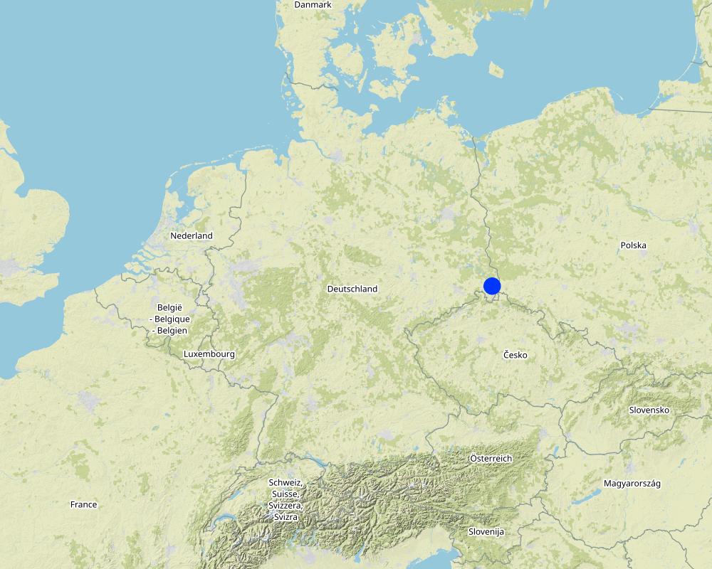
Map
×2.6 Date of implementation
Indicate year of implementation:
2022
If precise year is not known, indicate approximate date:
- less than 10 years ago (recently)
2.7 Introduction of the Technology
Specify how the Technology was introduced:
- through land users' innovation
Comments (type of project, etc.):
Initially, perennial ryegrass was used as an undersown crop to oats as a greening requirement of German agricultural policy. Later, the farmer decided to establish ryegrass as the main crop, including the discharge pathway.
3. Classification of the SLM Technology
3.1 Main purpose(s) of the Technology
- reduce, prevent, restore land degradation
- protect a watershed/ downstream areas – in combination with other Technologies
- preserve/ improve biodiversity
- adapt to climate change/ extremes and its impacts
3.2 Current land use type(s) where the Technology is applied
Land use mixed within the same land unit:
Yes
Specify mixed land use (crops/ grazing/ trees):
- Agro-pastoralism (incl. integrated crop-livestock)

Cropland
- Annual cropping
Annual cropping - Specify crops:
- fodder crops - grasses
- german rye grass
Number of growing seasons per year:
- 1
Specify:
one mowing per year for silage
Is intercropping practiced?
No
Is crop rotation practiced?
No

Grazing land
Intensive grazing/ fodder production:
- Improved pastures
Animal type:
- horses
Is integrated crop-livestock management practiced?
Yes
If yes, specify:
Using horse manure as fertilizer for the rye grass
Products and services:
- manure as fertilizer/ energy production
Species:
horses
Count:
2
Comments:
The actual use of the grassed waterway can be very different and also depends on its dimensions. In the documented example the grassed waterway was partially used for extensive grazing (horses).
3.3 Has land use changed due to the implementation of the Technology?
Has land use changed due to the implementation of the Technology?
- Yes (Please fill out the questions below with regard to the land use before implementation of the Technology)
Land use mixed within the same land unit:
No
Cropland
- Annual cropping
Annual cropping - Specify crops:
- cereals - oats
Is intercropping practiced?
Yes
If yes, specify which crops are intercropped:
german rye grass
Is crop rotation practiced?
No
3.4 Water supply
Water supply for the land on which the Technology is applied:
- rainfed
3.5 SLM group to which the Technology belongs
- improved ground/ vegetation cover
- water diversion and drainage
3.6 SLM measures comprising the Technology

vegetative measures
- V2: Grasses and perennial herbaceous plants
3.7 Main types of land degradation addressed by the Technology

soil erosion by water
- Wt: loss of topsoil/ surface erosion
- Wg: gully erosion/ gullying

soil erosion by wind
- Et: loss of topsoil

chemical soil deterioration
- Cn: fertility decline and reduced organic matter content (not caused by erosion)

physical soil deterioration
- Pc: compaction
- Pk: slaking and crusting

biological degradation
- Bc: reduction of vegetation cover
- Bh: loss of habitats
- Bl: loss of soil life

water degradation
- Hs: change in quantity of surface water
3.8 Prevention, reduction, or restoration of land degradation
Specify the goal of the Technology with regard to land degradation:
- prevent land degradation
- reduce land degradation
4. Technical specifications, implementation activities, inputs, and costs
4.1 Technical drawing of the Technology
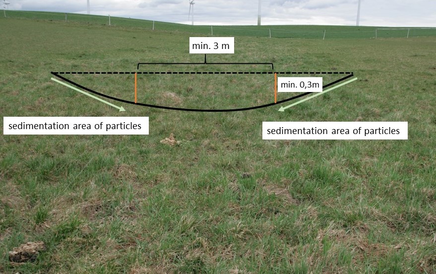
Technical specifications (related to technical drawing):
Normally, only the vulnerable lowest area of an agricultural field ( channel shape, bottom slope) needs to be grassed. LfULG recommends 1-4 m wide side slopes with a passable gradient of 1:10 (10%) and a total width of the upper slope of about 6 m and 15 m for the lower slope. The bottom of the drainage channel must be at least 3 m wide and 0.3 m deep. The side slopes are responsible for sedimentation of particles and the bottom for infiltration of water.
Author:
Mona Pauer based on LfULG 2010, p.27
Date:
23/03/2023

Technical specifications (related to technical drawing):
Guide values for the width (Top) of drainage channels depending on the size of the catchment area (EZG), the slope of the riverbed (Sohlengefälle) and the height (Höhe) of the drainage channel.
Author:
LfULG 2015, p. 7
Date:
05/01/2015
4.2 General information regarding the calculation of inputs and costs
Specify how costs and inputs were calculated:
- per Technology area
Indicate size and area unit:
1 ha
other/ national currency (specify):
€
If relevant, indicate exchange rate from USD to local currency (e.g. 1 USD = 79.9 Brazilian Real): 1 USD =:
0.91
Indicate average wage cost of hired labour per day:
18.70 € per hour
4.3 Establishment activities
| Activity | Timing (season) | |
|---|---|---|
| 1. | reseeding of ryegrass (drill seed) | spring |
| 2. | rolling (soil contact between plant and soil) | spring |
4.4 Costs and inputs needed for establishment
| Specify input | Unit | Quantity | Costs per Unit | Total costs per input | % of costs borne by land users | |
|---|---|---|---|---|---|---|
| Labour | seeding | ha | 1.0 | 20.19 | 20.19 | 100.0 |
| Labour | rolling | ha | 1.0 | 19.58 | 19.58 | 100.0 |
| Plant material | seeds | ha | 1.0 | 32.4 | 32.4 | 100.0 |
| Total costs for establishment of the Technology | 72.17 | |||||
| Total costs for establishment of the Technology in USD | 79.31 | |||||
Comments:
Based on a new subsidy programme (valid from 2023), the establishment and 5-year maintenance of a grassed waterways will be subsidised with 299€/ha in Saxony (Germany): https://www.smekul.sachsen.de/foerderung/download/Steckbrief_AL_1.pdf
This also partially compensates for the loss of yield and income.
4.5 Maintenance/ recurrent activities
| Activity | Timing/ frequency | |
|---|---|---|
| 1. | mulching | every spring |
| 2. | ploughing | every 5 years |
| 3. | reseeding | every 5 years |
Comments:
In Germany, grassland must be removed after 5 years (by ploughing or using chemicals) and then reseeded. Otherwise it becomes permanent grassland.
4.6 Costs and inputs needed for maintenance/ recurrent activities (per year)
| Specify input | Unit | Quantity | Costs per Unit | Total costs per input | % of costs borne by land users | |
|---|---|---|---|---|---|---|
| Labour | mulching | ha | 1.0 | 24.87 | 24.87 | 100.0 |
| Labour | ploughing | ha | 0.2 | 63.56 | 12.71 | 100.0 |
| Labour | reseeding | ha | 0.2 | 39.77 | 7.95 | 100.0 |
| Plant material | seeds | 32,4 | 0.2 | 32.4 | 6.48 | 100.0 |
| Total costs for maintenance of the Technology | 52.01 | |||||
| Total costs for maintenance of the Technology in USD | 57.15 | |||||
Comments:
Maintenance costs related to ploughing and reseeding are only required every five years. Therefore, they are based on the implementation costs and divided by 5.
4.7 Most important factors affecting the costs
Describe the most determinate factors affecting the costs:
Landowners complained that the additional yield (grass as fodder) would have no impact on their income. The loss of income due to the loss of arable land is greater and should be compensated by subsidy programs.
5. Natural and human environment
5.1 Climate
Annual rainfall
- < 250 mm
- 251-500 mm
- 501-750 mm
- 751-1,000 mm
- 1,001-1,500 mm
- 1,501-2,000 mm
- 2,001-3,000 mm
- 3,001-4,000 mm
- > 4,000 mm
Specify average annual rainfall (if known), in mm:
775.00
Indicate the name of the reference meteorological station considered:
https://whh-kliwes.de/mapview
Agro-climatic zone
- sub-humid
LGP: 209 days (https://www.umwelt.sachsen.de/dauer-der-vegetationsperiode-30631.html)
5.2 Topography
Slopes on average:
- flat (0-2%)
- gentle (3-5%)
- moderate (6-10%)
- rolling (11-15%)
- hilly (16-30%)
- steep (31-60%)
- very steep (>60%)
Landforms:
- plateau/plains
- ridges
- mountain slopes
- hill slopes
- footslopes
- valley floors
Altitudinal zone:
- 0-100 m a.s.l.
- 101-500 m a.s.l.
- 501-1,000 m a.s.l.
- 1,001-1,500 m a.s.l.
- 1,501-2,000 m a.s.l.
- 2,001-2,500 m a.s.l.
- 2,501-3,000 m a.s.l.
- 3,001-4,000 m a.s.l.
- > 4,000 m a.s.l.
Indicate if the Technology is specifically applied in:
- concave situations
Comments and further specifications on topography:
A grassed waterway is a strip of grassland (permanent vegetation close to the ground) established in the line of the lowest elevation (thalweg) of an agricultural field.
5.3 Soils
Soil depth on average:
- very shallow (0-20 cm)
- shallow (21-50 cm)
- moderately deep (51-80 cm)
- deep (81-120 cm)
- very deep (> 120 cm)
Soil texture (topsoil):
- coarse/ light (sandy)
- medium (loamy, silty)
Soil texture (> 20 cm below surface):
- medium (loamy, silty)
Topsoil organic matter:
- medium (1-3%)
If available, attach full soil description or specify the available information, e.g. soil type, soil PH/ acidity, Cation Exchange Capacity, nitrogen, salinity etc.
Luvisol (German soil classification system: Pseudogley Parabraunerde)
5.4 Water availability and quality
Ground water table:
< 5 m
Availability of surface water:
poor/ none
Water quality (untreated):
poor drinking water (treatment required)
Water quality refers to:
surface water
Is water salinity a problem?
No
Is flooding of the area occurring?
No
Comments and further specifications on water quality and quantity:
Heavy rainfall events cause flooding in the thalweg and erosion on the hillsides of the arable land. The field with the grassed waterway has had repeated erosion problems, with soil material being washed onto the adjacent road.
5.5 Biodiversity
Species diversity:
- low
Habitat diversity:
- low
Comments and further specifications on biodiversity:
Only one species is planted, but compared to oats, long-term grassland provides higher habitat quality and slightly higher biodiversity. The presence of shrubs and trees in the grassed waterway can further increase habitat diversity and species variety.
5.6 Characteristics of land users applying the Technology
Sedentary or nomadic:
- Sedentary
Market orientation of production system:
- commercial/ market
Off-farm income:
- less than 10% of all income
Relative level of wealth:
- average
Individuals or groups:
- individual/ household
Level of mechanization:
- mechanized/ motorized
Gender:
- women
- men
Age of land users:
- middle-aged
Indicate other relevant characteristics of the land users:
The landowner's son is studying agriculture, and the father is open to trying out the new knowledge on his land.
5.7 Average area of land used by land users applying the Technology
- < 0.5 ha
- 0.5-1 ha
- 1-2 ha
- 2-5 ha
- 5-15 ha
- 15-50 ha
- 50-100 ha
- 100-500 ha
- 500-1,000 ha
- 1,000-10,000 ha
- > 10,000 ha
Is this considered small-, medium- or large-scale (referring to local context)?
- small-scale
5.8 Land ownership, land use rights, and water use rights
Land ownership:
- individual, not titled
Land use rights:
- leased
- individual
Water use rights:
- communal (organized)
Are land use rights based on a traditional legal system?
No
5.9 Access to services and infrastructure
health:
- poor
- moderate
- good
education:
- poor
- moderate
- good
technical assistance:
- poor
- moderate
- good
employment (e.g. off-farm):
- poor
- moderate
- good
markets:
- poor
- moderate
- good
energy:
- poor
- moderate
- good
roads and transport:
- poor
- moderate
- good
drinking water and sanitation:
- poor
- moderate
- good
financial services:
- poor
- moderate
- good
6. Impacts and concluding statements
6.1 On-site impacts the Technology has shown
Socio-economic impacts
Production
fodder production
Comments/ specify:
The loss of arable land (used for forage oats) cannot be compensated by harvesting grass on the runoff path.
fodder quality
risk of production failure
production area
Comments/ specify:
Measure does not affect yield, but means a loss of area.
Income and costs
expenses on agricultural inputs
Comments/ specify:
Costs for seeds
farm income
diversity of income sources
workload
Comments/ specify:
If a whole field is converted to a grassed waterway workload decreases. However, for a typical grassed waterway (just greening of the thalweg) an increase in workload can be expected.
Ecological impacts
Water cycle/ runoff
surface runoff
Comments/ specify:
Reduction in surface water runoff.
Soil
soil moisture
soil cover
soil loss
soil accumulation
soil compaction
soil organic matter/ below ground C
Biodiversity: vegetation, animals
Vegetation cover
plant diversity
invasive alien species
habitat diversity
pest/ disease control
Climate and disaster risk reduction
drought impacts
Specify assessment of on-site impacts (measurements):
The reported on-site impacts are estimates of the respondents and are not based on measurements.
6.2 Off-site impacts the Technology has shown
water availability
groundwater/ river pollution
buffering/ filtering capacity
damage on neighbours' fields
damage on public/ private infrastructure
Comments/ specify:
No more soil deposits in the yard/on the street.
Specify assessment of off-site impacts (measurements):
The reported on-site impacts are estimates of the respondents and of the compilers. They are not based on local measurements.
6.3 Exposure and sensitivity of the Technology to gradual climate change and climate-related extremes/ disasters (as perceived by land users)
Gradual climate change
Gradual climate change
| Season | increase or decrease | How does the Technology cope with it? | |
|---|---|---|---|
| seasonal temperature | spring | increase | well |
Climate-related extremes (disasters)
Meteorological disasters
| How does the Technology cope with it? | |
|---|---|
| local rainstorm | well |
6.4 Cost-benefit analysis
How do the benefits compare with the establishment costs (from land users’ perspective)?
Short-term returns:
slightly negative
Long-term returns:
slightly negative
How do the benefits compare with the maintenance/ recurrent costs (from land users' perspective)?
Short-term returns:
slightly negative
Long-term returns:
slightly negative
6.5 Adoption of the Technology
- single cases/ experimental
Of all those who have adopted the Technology, how many did so spontaneously, i.e. without receiving any material incentives/ payments?
- 91-100%
6.6 Adaptation
Has the Technology been modified recently to adapt to changing conditions?
No
6.7 Strengths/ advantages/ opportunities of the Technology
| Strengths/ advantages/ opportunities in the land user’s view |
|---|
| Compared to other erosion control measures, the area of the grassed waterway can continue to be used (extensively) for forage and grazing. |
| In Germany, the greened areas could be used as required greening areas for the direct payments of the agricultural policy. |
| Strengths/ advantages/ opportunities in the compiler’s or other key resource person’s view |
|---|
| Grassed waterways are highly recommended and beneficial in preventing on-site gully erosion and off-site pollution of water bodies. |
| Due to their more technical background, the conservation value is not as high as for other measures, but they are still considered as a biotope network as well as a habitat for grassland breeders when extensively managed. |
6.8 Weaknesses/ disadvantages/ risks of the Technology and ways of overcoming them
| Weaknesses/ disadvantages/ risks in the land user’s view | How can they be overcome? |
|---|---|
| In Germany, grassland becomes permanent if it is not converted within five years. This often leads to a conflict of interest between landowners and land-users. A permanent change in land-use (from arable land to permanent grassland) would mean a loss in land value. | As a result, the farmers plough and reseed the area after five years. With a change in regulations for certain measures, e.g. if land is used for nature conservation, it could remain cropland after five years without being converted. |
| A structure in the middle of a field is impractical in terms of tracks for machinery. | Sometimes it may be beneficial to green the entire field or subdivide the field with a linear structure. |
7. References and links
7.1 Methods/ sources of information
- field visits, field surveys
1
- interviews with land users
1
- compilation from reports and other existing documentation
4
When were the data compiled (in the field)?
23/03/2023
7.3 Links to relevant online information
Title/ description:
LfULG (2010): Erosionsschutz in reliefbedingten Abflussbahnen, Schriftenreihe, Heft 13
URL:
https://www.boden.sachsen.de/erosionsschutz-in-reliefbedingten-abflussbahnen-18074.html
Title/ description:
United States Department of Agriculture (2020): Grassed Waterway - Conservation Practice Standard
URL:
https://www.nrcs.usda.gov/resources/guides-and-instructions/grassed-waterway-ac-412-conservation-practice-standard
Title/ description:
LfULG (2015): Begrünung von erosionsgefährdeten Abflussbahnen. Broschüre
URL:
https://publikationen.sachsen.de/bdb/artikel/23739
Title/ description:
Fiener & Auerswald (2006): Seasonal variation of grassed waterway effectiveness in reducing runoff and sediment delivery from agricultural watersheds in temperate Europe. Soil and Tillage Research 87, 48–58.
URL:
https://doi.org/10.1016/j.still.2005.02.035
Title/ description:
Wasserhaushaltsportal Sachsen: KLiWES 2.1 IST-Zustand 1988-2015
URL:
https://whh-kliwes.de/mapview
Links and modules
Expand all Collapse allLinks
No links
Modules
No modules