Anti erosion measures [Burkina Faso]
- Creation:
- Update:
- Compiler: Rebecka Ridder
- Editor: –
- Reviewers: Rima Mekdaschi Studer, Alexandra Gavilano
technologies_613 - Burkina Faso
View sections
Expand all Collapse all1. General information
1.2 Contact details of resource persons and institutions involved in the assessment and documentation of the Technology
Key resource person(s)
SLM specialist:
Konombo Mouni
AFC / GOPA
Burkina Faso
SLM specialist:
Some Justine
AFC / GOPA
Burkina Faso
SLM specialist:
Cisse Drissa
AFC / GOPA
Burkina Faso
Name of the institution(s) which facilitated the documentation/ evaluation of the Technology (if relevant)
Deutsche Gesellschaft für Internationale Zusammenarbeit (GIZ) GmbH (GIZ) - Germany1.3 Conditions regarding the use of data documented through WOCAT
The compiler and key resource person(s) accept the conditions regarding the use of data documented through WOCAT:
Yes
1.4 Declaration on sustainability of the described Technology
Is the Technology described here problematic with regard to land degradation, so that it cannot be declared a sustainable land management technology?
No
1.5 Reference to Questionnaire(s) on SLM Approaches (documented using WOCAT)
Combating erosion, recovery and enhancement of degraded land … [Burkina Faso]
The approach applied in this project is an integrated and multi-stakeholder approach in the South West of Burkina Faso, based on watershed management and sustainable land management with a strong emphasis on local participation. It carries out physical and biological measures against erosion, adaptation to climate change and various activities …
- Compiler: Rebecka Ridder
2. Description of the SLM Technology
2.1 Short description of the Technology
Definition of the Technology:
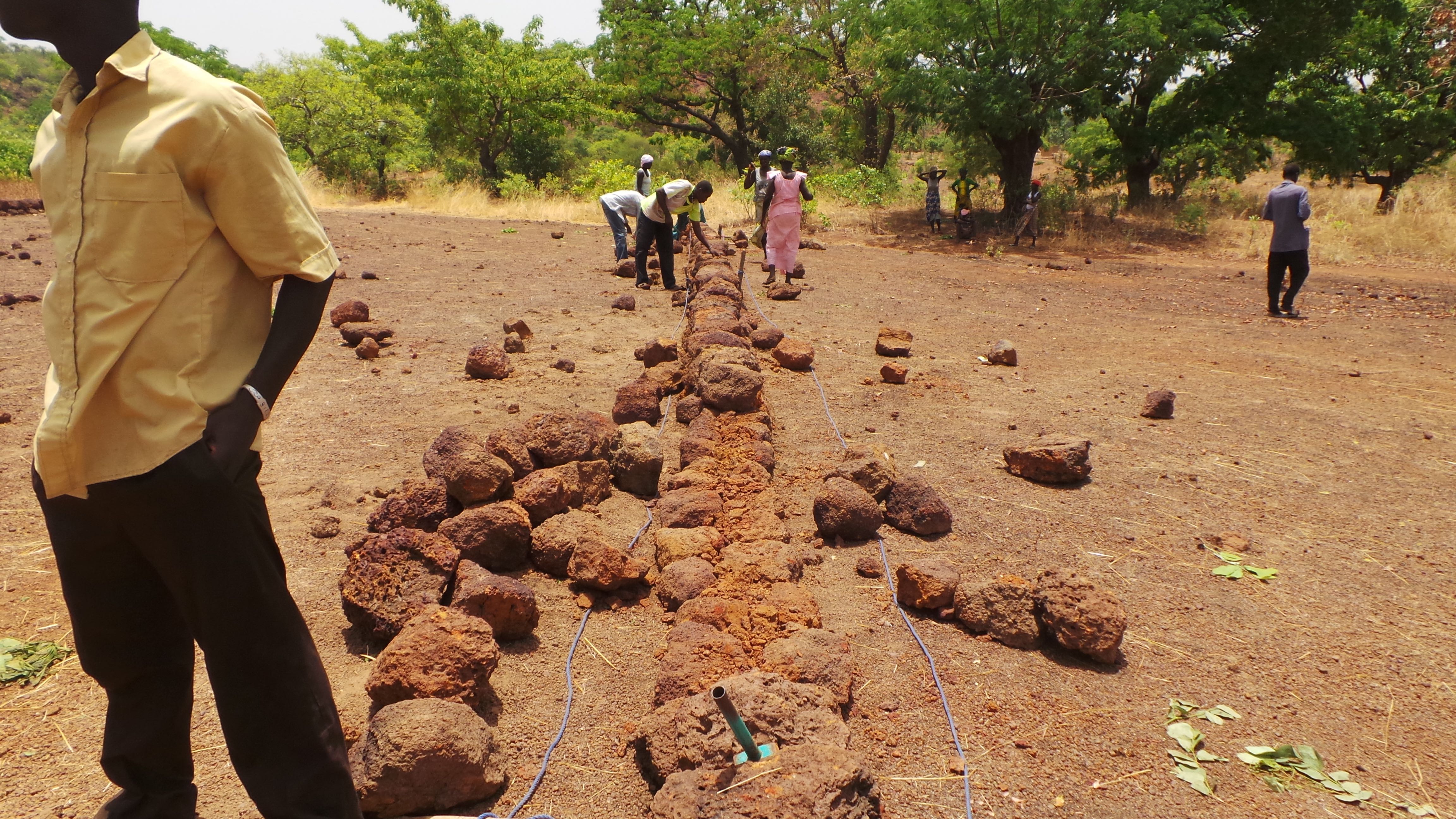
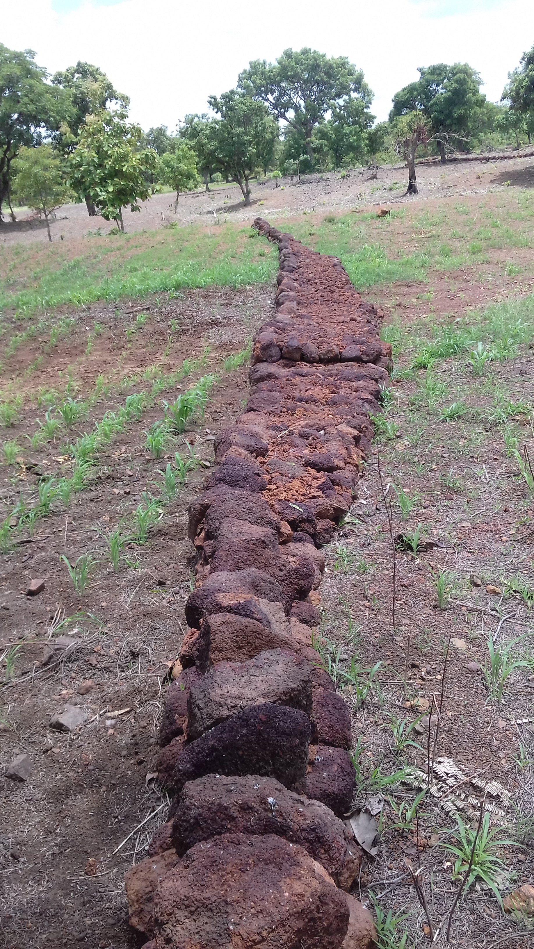
Combining different measures such as stone rows, dikes and dams to stabilize and restore the soil and increase water infiltration. Trees alongside these structures allow an enhancement of these structural measures.
2.2 Detailed description of the Technology
Description:
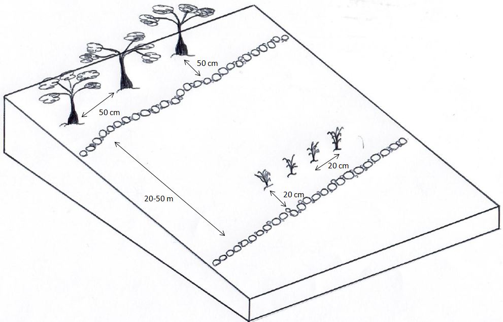
The main objective is the recovery of 20,000 hectares of degraded land by the project 'Combating erosion, recovery and enhancement of degraded land and climate change adaptation (EKF)' until 2019. This should be achieved through a combination of structural measures such as stone rows, and biological measures such as revegetation and agroforestry.
The EKF project carries out four types of land improvement techniques:
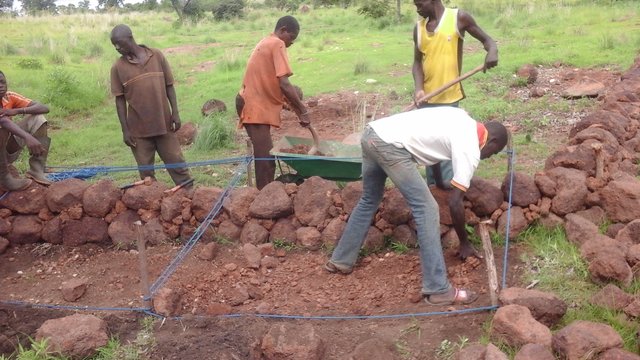
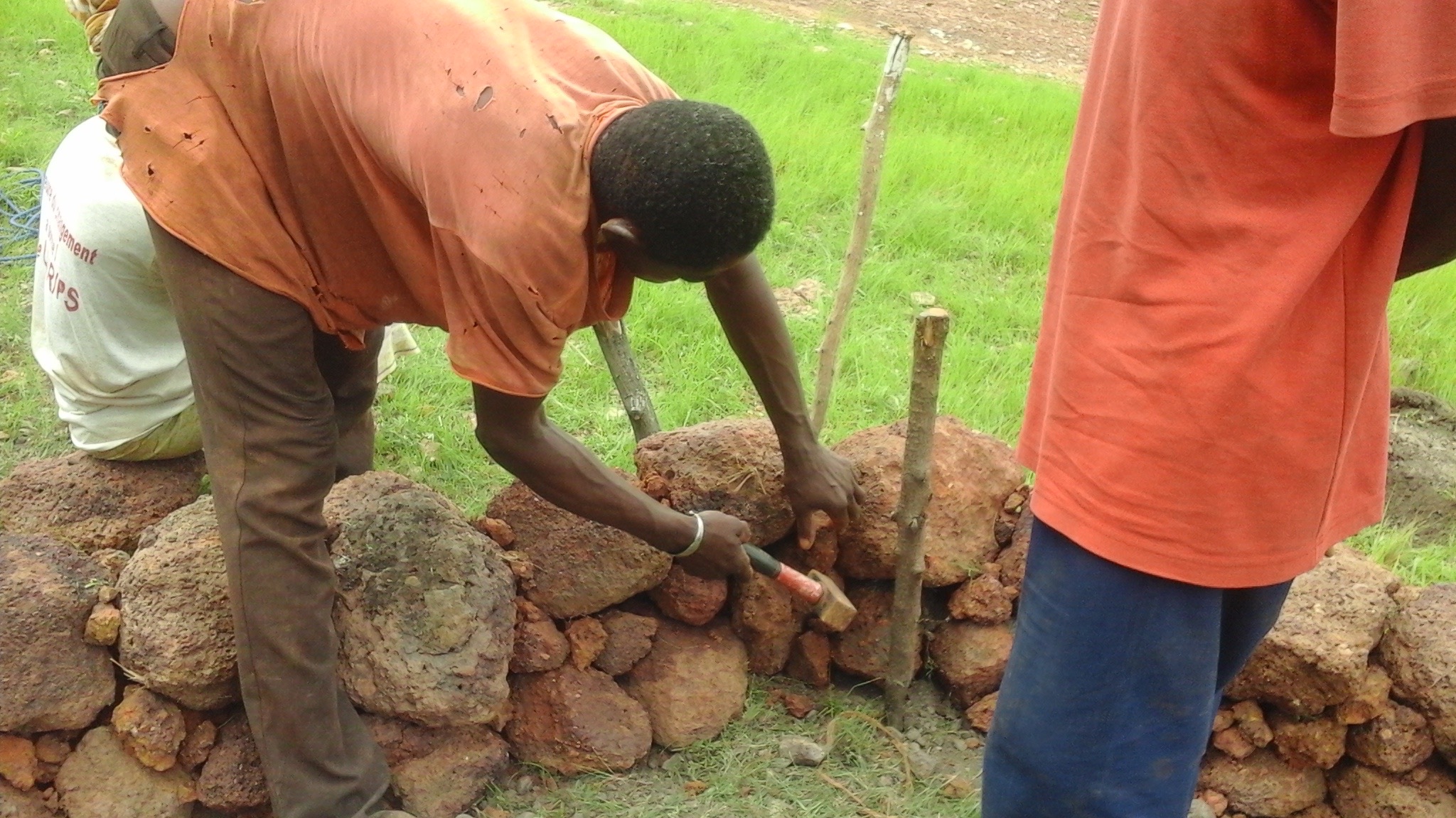
Contour stone rows, permeable rock dams, permeable rock dikes as well as the treatment of gully erosion. In order to strengthen their performance, these structures are vegetated with grasses (Andropogon gayanus, Cymbopogon sp, Vetiveria zizanioides) or tree species (Jatropha curcas, Acacia nilotica, Agave sisalana).
Working groups are created for the construction and maintenance.
The described measures help to protect the land against erosion caused by runoff, by slowing down runoff and spreading it over the land. In this way the structures increase water infiltration and not only help to act against erosion caused by runoff (thereby preventing the loss of rainwater), but also increase sedimentation and act as a filter by keeping waterborne particles on the land. In areas of erratic rainfall, these measures help to conserve soil moisture.
Vegetation helps to stabilize the structures and is furthermore an effective measure to protect the land against water and wind erosion. The right grass or tree species must be chosen to ensure the longevity of the structures. Preferences and needs of land users are taken into account as trees and grasses provide products and byproducts (bearing economic benefits), but also provide fodder for livestock and increase overall biodiversity.
2.3 Photos of the Technology
Media Gallery


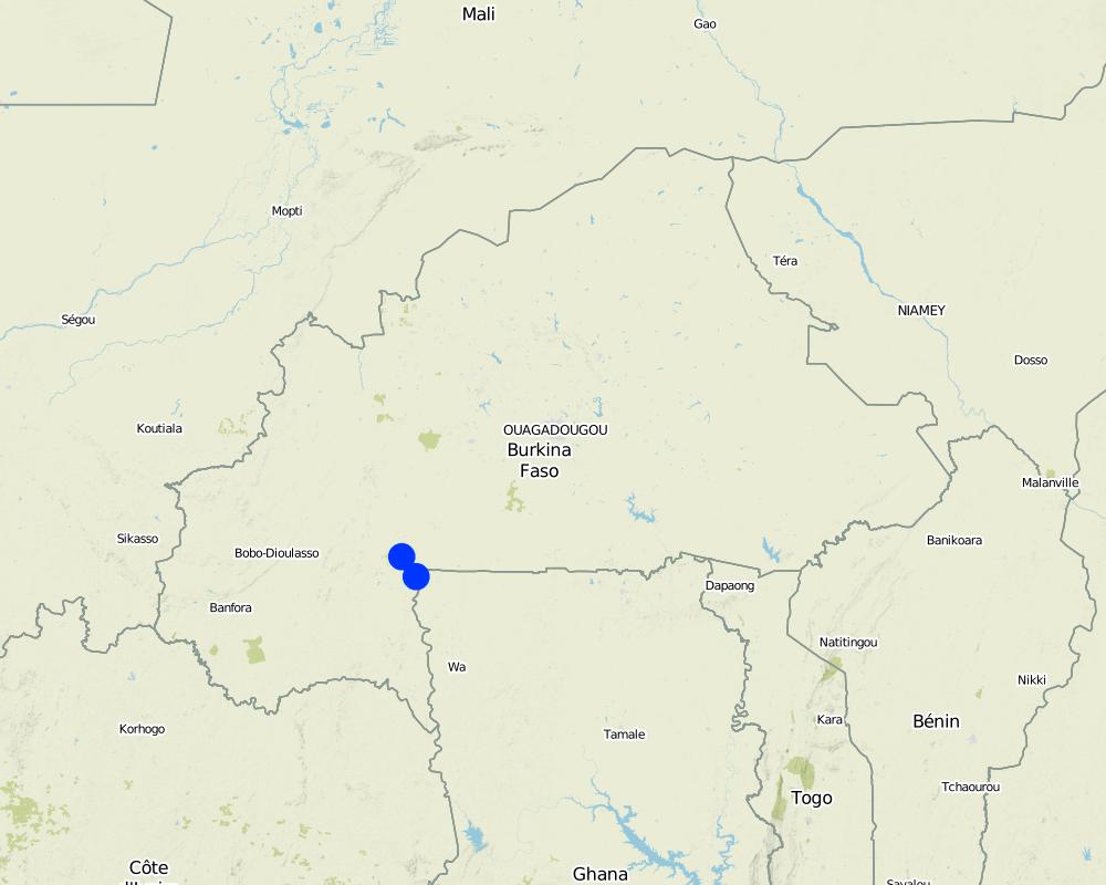
2.5 Country/ region/ locations where the Technology has been applied and which are covered by this assessment
Country:
Burkina Faso
Region/ State/ Province:
South West
Specify the spread of the Technology:
- evenly spread over an area
If precise area is not known, indicate approximate area covered:
- 100-1,000 km2
Comments:
The project's intervention is focused on six pilot municipalities in the region.
The goal is to reach 200 km until 2019 (end of project).
Map
×2.6 Date of implementation
If precise year is not known, indicate approximate date:
- less than 10 years ago (recently)
2.7 Introduction of the Technology
Specify how the Technology was introduced:
- through projects/ external interventions
Comments (type of project, etc.):
Stone rows are part of a local knowledge that has been known and implemented in Burkina for generations.
The combination of technologies and certain aspects are based on the project's interventions.
3. Classification of the SLM Technology
3.1 Main purpose(s) of the Technology
- reduce, prevent, restore land degradation
- conserve ecosystem
- protect a watershed/ downstream areas – in combination with other Technologies
- reduce risk of disasters
- adapt to climate change/ extremes and its impacts
- mitigate climate change and its impacts
- create beneficial economic impact
3.2 Current land use type(s) where the Technology is applied
Land use mixed within the same land unit:
Yes
Specify mixed land use (crops/ grazing/ trees):
- Agro-silvopastoralism

Cropland
- Annual cropping
- Perennial (non-woody) cropping
Annual cropping - Specify crops:
- fodder crops - grasses
- Andropogon gayanus, Cymbopogon sp, Vetiveria zizanioides
Number of growing seasons per year:
- 1

Grazing land
Extensive grazing:
- Semi-nomadic pastoralism

Forest/ woodlands
Type of tree:
- Acacia nilotica
- Jatropha curcas and Agave sisalana
Products and services:
- Fuelwood
3.4 Water supply
Water supply for the land on which the Technology is applied:
- rainfed
3.5 SLM group to which the Technology belongs
- improved ground/ vegetation cover
- integrated soil fertility management
3.6 SLM measures comprising the Technology

vegetative measures
- V2: Grasses and perennial herbaceous plants

structural measures
- S2: Bunds, banks
3.7 Main types of land degradation addressed by the Technology

soil erosion by water
- Wt: loss of topsoil/ surface erosion
- Wg: gully erosion/ gullying
- Wo: offsite degradation effects

soil erosion by wind
- Et: loss of topsoil
- Ed: deflation and deposition
- Eo: offsite degradation effects

physical soil deterioration
- Pk: slaking and crusting

biological degradation
- Bh: loss of habitats
- Bs: quality and species composition/ diversity decline
- Bl: loss of soil life

water degradation
- Ha: aridification
- Hg: change in groundwater/aquifer level
3.8 Prevention, reduction, or restoration of land degradation
Specify the goal of the Technology with regard to land degradation:
- reduce land degradation
- restore/ rehabilitate severely degraded land
4. Technical specifications, implementation activities, inputs, and costs
4.1 Technical drawing of the Technology
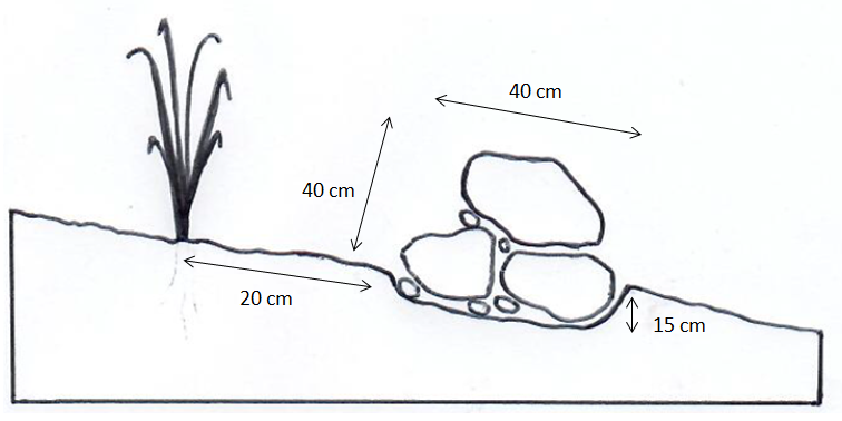
Technical specifications (related to technical drawing):
Contour stone bunds (shown in the drawing): Contour stone bunds are erosion control structures built with rocks or stones along a natural contour. They are made up of three stones, two of which form the foundation (partly embedded in the ground) and the third being placed on top. Small stones are used as "filling material" and also act as a filter. For small slopes (< 3%), one stone row each 50 to 60 meters can be constructed and each 20-30 meters for steeper slopes.
Technical standards:
- Height: 40 cm
- Embedded in soil: 15 cm
- Width: 40 cm.
Permeable rock dam: Rock dams are an erosion control structure built in gullies. They consist of rubble as foundation and may contain spillways.
Technical standards:
- Height: 0.7-1.2 m
- Width: 3 times the height
- Embedded in soil: 30 cm
Permeable rock dike:
Definition: Unlike the dam, the dike is built alongside natural contours. It is larger in size and therefore can control stronger water flow
Technical standards:
- Height: 0.6-1.1 m
- Width: 3 times height
- Embedded in soil: 30 cm
Biological measures: To ensure the durability of these constructions, different species are planted. These may be herbaceous species (Andropogon gayanus, Cymbopogon sp, Vetiveria zizanoides) or tree species (Jatropha curcas, Acacia nilotica, Agave sisalana).
4.2 General information regarding the calculation of inputs and costs
Specify how costs and inputs were calculated:
- per Technology unit
Specify unit:
Meter of stone row
other/ national currency (specify):
F CFA
If relevant, indicate exchange rate from USD to local currency (e.g. 1 USD = 79.9 Brazilian Real): 1 USD =:
584.5
4.3 Establishment activities
| Activity | Timing (season) | |
|---|---|---|
| 1. | Formation of working groups | |
| 2. | Topographic survey | |
| 3. | Collection of stones | |
| 4. | Transport of stones and construction of anti-erosion measure | April to June |
| 5. | Technical and official approval | |
| 6. | Planting of trees | July and August |
4.4 Costs and inputs needed for establishment
| Specify input | Unit | Quantity | Costs per Unit | Total costs per input | % of costs borne by land users | |
|---|---|---|---|---|---|---|
| Labour | Labour force for the construction | Metres | 2855.0 | 320.0 | 913600.0 | |
| Labour | Topographic data collection | Metres | 2855.0 | 60.0 | 171300.0 | |
| Equipment | Working kit | Day | 13.0 | 858.0 | 11154.0 | |
| Equipment | Transport of Stones | Cubic Metres | 571.0 | 2000.0 | 1142000.0 | |
| Plant material | Trees | Amount of trees | 224.0 | 200.0 | 44800.0 | |
| Total costs for establishment of the Technology | 2282854.0 | |||||
| Total costs for establishment of the Technology in USD | 3905.65 | |||||
If land user bore less than 100% of costs, indicate who covered the remaining costs:
Financed by the project
Comments:
Costs are calculated for the permeable rock dams
These costs do not include the following:
- Salaries and operating costs of the project team;
- Supplies (notebooks and pens) for the working groups;
- Pharmaceutical supplies for the working groups;
- The contract grant for the implementation and monitoring of the activities of vegetation;
- The operating costs of the maintenance;
- The training of farmers on erosion control techniaues
5. Natural and human environment
5.1 Climate
Annual rainfall
- < 250 mm
- 251-500 mm
- 501-750 mm
- 751-1,000 mm
- 1,001-1,500 mm
- 1,501-2,000 mm
- 2,001-3,000 mm
- 3,001-4,000 mm
- > 4,000 mm
Specifications/ comments on rainfall:
Precipitation:
Over the last decade, the local population has observed a decrease in the amount and frequency of rain, an increase of droughts (longer than 15 to 30 days), and a decreased water table.
Temperature:
The cold period was shortened from four months (mid-November to early March) to three months (December-January). The hot period has become longer and therefore more intense. The average minimum and maximum of the past 33 years respectively is 21.59 ° C and 34.68 ° C.
Winds:
The winds have become more violent and devastating. Their frequency has increased over the past decade.
Local causes of climate change:
Changes in climate patterns observed in the Southwest region are attributed mainly to human actions. These actions are bush fires, uncontrolled deforestation, mining and extensive agriculture and rapid population growth
Indicate the name of the reference meteorological station considered:
Gaoua
Agro-climatic zone
- sub-humid
5.2 Topography
Slopes on average:
- flat (0-2%)
- gentle (3-5%)
- moderate (6-10%)
- rolling (11-15%)
- hilly (16-30%)
- steep (31-60%)
- very steep (>60%)
Landforms:
- plateau/plains
- ridges
- mountain slopes
- hill slopes
- footslopes
- valley floors
Altitudinal zone:
- 0-100 m a.s.l.
- 101-500 m a.s.l.
- 501-1,000 m a.s.l.
- 1,001-1,500 m a.s.l.
- 1,501-2,000 m a.s.l.
- 2,001-2,500 m a.s.l.
- 2,501-3,000 m a.s.l.
- 3,001-4,000 m a.s.l.
- > 4,000 m a.s.l.
Indicate if the Technology is specifically applied in:
- not relevant
5.3 Soils
Soil depth on average:
- very shallow (0-20 cm)
- shallow (21-50 cm)
- moderately deep (51-80 cm)
- deep (81-120 cm)
- very deep (> 120 cm)
Soil texture (topsoil):
- coarse/ light (sandy)
Soil texture (> 20 cm below surface):
- coarse/ light (sandy)
Topsoil organic matter:
- medium (1-3%)
If available, attach full soil description or specify the available information, e.g. soil type, soil PH/ acidity, Cation Exchange Capacity, nitrogen, salinity etc.
Most are leached tropical ferruginous soils on sandy material and sandy clay. They are acidic (4.4 <pH <5.9), the nitrogen content is between 0.044 and 0.088%.
5.4 Water availability and quality
Ground water table:
5-50 m
Availability of surface water:
medium
Water quality (untreated):
for agricultural use only (irrigation)
Is water salinity a problem?
No
Is flooding of the area occurring?
Yes
Regularity:
episodically
5.5 Biodiversity
Species diversity:
- medium
Habitat diversity:
- medium
5.6 Characteristics of land users applying the Technology
Sedentary or nomadic:
- Sedentary
Market orientation of production system:
- mixed (subsistence/ commercial)
Relative level of wealth:
- poor
Individuals or groups:
- individual/ household
Level of mechanization:
- manual work
- animal traction
5.7 Average area of land used by land users applying the Technology
- < 0.5 ha
- 0.5-1 ha
- 1-2 ha
- 2-5 ha
- 5-15 ha
- 15-50 ha
- 50-100 ha
- 100-500 ha
- 500-1,000 ha
- 1,000-10,000 ha
- > 10,000 ha
Is this considered small-, medium- or large-scale (referring to local context)?
- small-scale
Comments:
The majority of land users practice small scale agriculture, even if some bigger producers exist.
5.8 Land ownership, land use rights, and water use rights
Land ownership:
- individual, not titled
Land use rights:
- open access (unorganized)
- individual
Water use rights:
- open access (unorganized)
5.9 Access to services and infrastructure
health:
- poor
- moderate
- good
education:
- poor
- moderate
- good
technical assistance:
- poor
- moderate
- good
employment (e.g. off-farm):
- poor
- moderate
- good
markets:
- poor
- moderate
- good
energy:
- poor
- moderate
- good
roads and transport:
- poor
- moderate
- good
drinking water and sanitation:
- poor
- moderate
- good
financial services:
- poor
- moderate
- good
6. Impacts and concluding statements
6.1 On-site impacts the Technology has shown
Socio-economic impacts
Production
non-wood forest production
Comments/ specify:
Le jatropha a été planté dans le carde du projet.
risk of production failure
Comments/ specify:
Avant la technologie, les eaux des ruissellement ont transportés la semis. La technologie aide à fixer la semis
et elle contribue à l'infiltration d'eau et à surmonter les courtes poches de sécheresse.
product diversity
Comments/ specify:
La technologie aide les producteurs à diversifier leur production, par ex. avant la mise en place de la technologie , il y avait des régions où les producteurs ne cultivaient pas le mais.
Income and costs
expenses on agricultural inputs
Comments/ specify:
Les membres de groupes de travail sont payés et utilisent l’argent pour les intrants
diversity of income sources
Comments/ specify:
La technologie aide les femmes à diversifier leurs cultures et l'argent gagné de la construction soulève leur revenu. Cet argent est investi dans le petit commerce.
Socio-cultural impacts
health situation
Comments/ specify:
Avec la rénumeration de la construction, la population investit dans l'éducation et les matières sanitaires
community institutions
Comments/ specify:
Existence et entretien des groupes de travail (dix groupes par bassin)
national institutions
Comments/ specify:
Avant la technologie, il n’ y avait pas de contact entre la population locale et les services techniques de l’Etat
SLM/ land degradation knowledge
Comments/ specify:
Création d'une ingenièrie villageoise
situation of socially and economically disadvantaged groups
Comments/ specify:
Les groupes de travail sont formés avec une diversité au genre. Il y a aussi des groupes avec plus de femmes que d'hommes.
Il y a des personnes qui peuvent bénéficier de la construction de ces structures, même si elles ne participent pas à les construire eux-mêmes en raison de leur âge.
Ecological impacts
Water cycle/ runoff
surface runoff
Comments/ specify:
Les structures ralentissent la vitesse d'eau.
groundwater table/ aquifer
Comments/ specify:
La technologie permet de monter la nappe, mais une étude n’a pas été réalisée.
Biodiversity: vegetation, animals
Vegetation cover
Comments/ specify:
Il y a une regeneration naturelle
plant diversity
Comments/ specify:
Espèces comme l'Andropodon gayanus ou Vetiveria zizanoides sont revenues.
beneficial species
Comments/ specify:
Vers de terres et en particulier les termites.
Climate and disaster risk reduction
drought impacts
Comments/ specify:
Barrières peuvent retenir l’eau pour assurer une infiltration du sol et supporter la sécheresse pour un court terme
wind velocity
Comments/ specify:
La technologie augmente le couvert végétal.
6.3 Exposure and sensitivity of the Technology to gradual climate change and climate-related extremes/ disasters (as perceived by land users)
Gradual climate change
Gradual climate change
| Season | increase or decrease | How does the Technology cope with it? | |
|---|---|---|---|
| annual temperature | increase | very well | |
| seasonal temperature | dry season | increase | very well |
Climate-related extremes (disasters)
Meteorological disasters
| How does the Technology cope with it? | |
|---|---|
| local rainstorm | very well |
| local thunderstorm | very well |
| local hailstorm | very well |
| local windstorm | very well |
Climatological disasters
| How does the Technology cope with it? | |
|---|---|
| heatwave | very well |
| drought | very well |
| forest fire | well |
| land fire | well |
Hydrological disasters
| How does the Technology cope with it? | |
|---|---|
| flash flood | very well |
6.4 Cost-benefit analysis
How do the benefits compare with the establishment costs (from land users’ perspective)?
Short-term returns:
slightly positive
Comments:
The approach began in 2013, only short term benefits exist.
It is clear that the costs of implementation are comparatively high (equipment of working groups, topographic surveys, labour costs, transportation costs).
So far, there has not been maintenance costs. The anti erosion measures are regularly maintained, but this has involved no costs.
A study of financial profitability shows that it takes about five (5) seasons in order to evaluate the investments.
6.6 Adaptation
Has the Technology been modified recently to adapt to changing conditions?
No
6.7 Strengths/ advantages/ opportunities of the Technology
| Strengths/ advantages/ opportunities in the land user’s view |
|---|
| Allows to retrieve and restore degraded and bare soil for agricultural use and an increase in cultivable and pastoral areas. Fertility is restored and the production / yield increases. In addition, there is a diversification of crop and animal production |
| Decrease of runoff. Before the technologies were in place, heavy runoff would damage houses and wash away seeds. |
| Improves education and school attendance as well as health facilities |
| Strengths/ advantages/ opportunities in the compiler’s or other key resource person’s view |
|---|
| Awareness raising in sustainable land management and development of a local knowledge system |
| Decrease of migration flows / rural-urban migration |
| Creating social cohesion and incorporating a gender dimension |
6.8 Weaknesses/ disadvantages/ risks of the Technology and ways of overcoming them
| Weaknesses/ disadvantages/ risks in the land user’s view | How can they be overcome? |
|---|---|
| The anti erosion works are built over long distances. In the past, house owners have destroyed stone rows for example if they are built too close to their house in order to allow rainwater to pass. | The technology can be adapted, house owners must be involved in planning processes |
| Risk of snakes and reptiles | Land users must be involved in the construction. Children must not destroy the anti erosion works. |
| Weaknesses/ disadvantages/ risks in the compiler’s or other key resource person’s view | How can they be overcome? |
|---|---|
| High costs of the technology. If the land user has to bear these costs, the technology is not replicable. | The project has not found a solution. |
| In depression areas there may be water-logging | The project has not found a solution. |
| There are areas with soil degradation where the primary material (stones) is not available. | Neighbouring villages (with primary material) must be included in the planning process |
7. References and links
7.1 Methods/ sources of information
- field visits, field surveys
- interviews with land users
- interviews with SLM specialists/ experts
- compilation from reports and other existing documentation
When were the data compiled (in the field)?
20/09/2016
7.3 Links to relevant online information
Title/ description:
Good practices in water and soil conservation. A contribution to adaptation and farmers' resilience towards climate change in the Sahel. 2012
URL:
https://www.giz.de/fachexpertise/downloads/giz2012-en-good-practices-in-soil-and-water-conservation.pdf.
Links and modules
Expand all Collapse allLinks
Combating erosion, recovery and enhancement of degraded land … [Burkina Faso]
The approach applied in this project is an integrated and multi-stakeholder approach in the South West of Burkina Faso, based on watershed management and sustainable land management with a strong emphasis on local participation. It carries out physical and biological measures against erosion, adaptation to climate change and various activities …
- Compiler: Rebecka Ridder
Modules
No modules