Controlled traffic farming [Hungary]
- Creation:
- Update:
- Compiler: Brigitta Szabó
- Editors: Piroska Kassai, Zoltan Toth
- Reviewers: William Critchley, Rima Mekdaschi Studer
Művelőnyomos növénytermesztés
technologies_6202 - Hungary
View sections
Expand all Collapse all1. General information
1.2 Contact details of resource persons and institutions involved in the assessment and documentation of the Technology
Key resource person(s)
land user:
Berend Ferenc
Berend Kft
Hungary
Name of project which facilitated the documentation/ evaluation of the Technology (if relevant)
OPtimal strategies to retAIN and re-use water and nutrients in small agricultural catchments across different soil-climatic regions in Europe (OPTAIN)Name of the institution(s) which facilitated the documentation/ evaluation of the Technology (if relevant)
Institute for Soil Sciences, Centre for Agricultural Research (ATK TAKI) - Hungary1.3 Conditions regarding the use of data documented through WOCAT
The compiler and key resource person(s) accept the conditions regarding the use of data documented through WOCAT:
Yes
1.4 Declaration on sustainability of the described Technology
Is the Technology described here problematic with regard to land degradation, so that it cannot be declared a sustainable land management technology?
No
1.5 Reference to Questionnaire(s) on SLM Approaches (documented using WOCAT)
Conservation tillage [Hungary]
Non inversion, conservation (soil and water protective) tillage.
- Compiler: Adam Kertesz
2. Description of the SLM Technology
2.1 Short description of the Technology
Definition of the Technology:
All machinery traffic uses the same lane network within the field to reduce the total compacted area, to improve connections, and to optimise overlapping of following runs resulting in more efficient use of labour and inputs. Risks from environmental pollution are also reduced.
2.2 Detailed description of the Technology
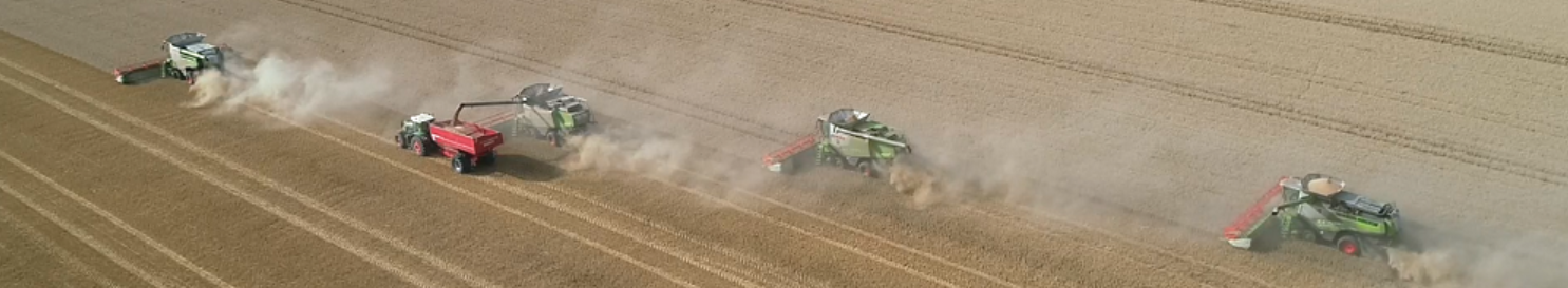
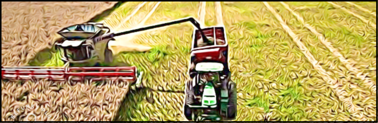
Description:
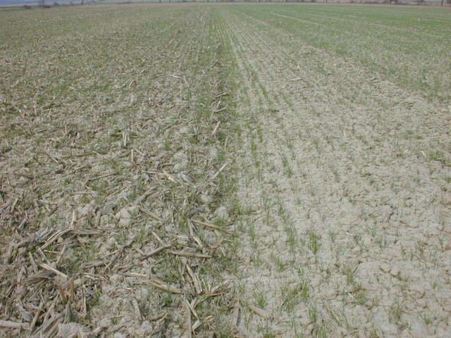
Under controlled traffic farming, all field machinery uses the same lane network within the field. This is to reduce the total compacted area, to improve connections, and to optimise overlapping of return runs, resulting in more efficient use of labour and inputs. Risks from environmental pollution are also reduced. The technology is applied to arable fields.
The main principle is to confine all machinery-earth contact to the least possible area by using permanent traffic lanes. The aim is to minimise the area compacted area while improving connections and optimising the cover of operations (so that, for example, spraying doesn’t double the dose on a portion of the crop). For application of the technology, working widths of machines have to be synchronised to use the same (or multiple) working widths. For keeping directions and parallel traffic precisely Real Time Correction GPS need to be used.
The key benefit of the technology is that the compacted area can be reduced to 15-20% of the field and this is always in the same place. Due to the precision of next/ return runs of machinery, this means more efficient use of time and 15-20% less input materials used. Risk of environment pollution is correspondingly smaller. Under this system, conventional tillage (e.g. mouldboard ploughing) is not possible, only reduced, non-inversion tillage (“no-till”) can be employed. Correspondingly, mechanical weed control may be less effective under this system.
2.3 Photos of the Technology
Media Gallery

2.4 Videos of the Technology
Comments, short description:
video is not available
2.5 Country/ region/ locations where the Technology has been applied and which are covered by this assessment
Country:
Hungary
Region/ State/ Province:
Somogy County
Further specification of location:
Vityapuszta
Specify the spread of the Technology:
- applied at specific points/ concentrated on a small area
Is/are the technology site(s) located in a permanently protected area?
No
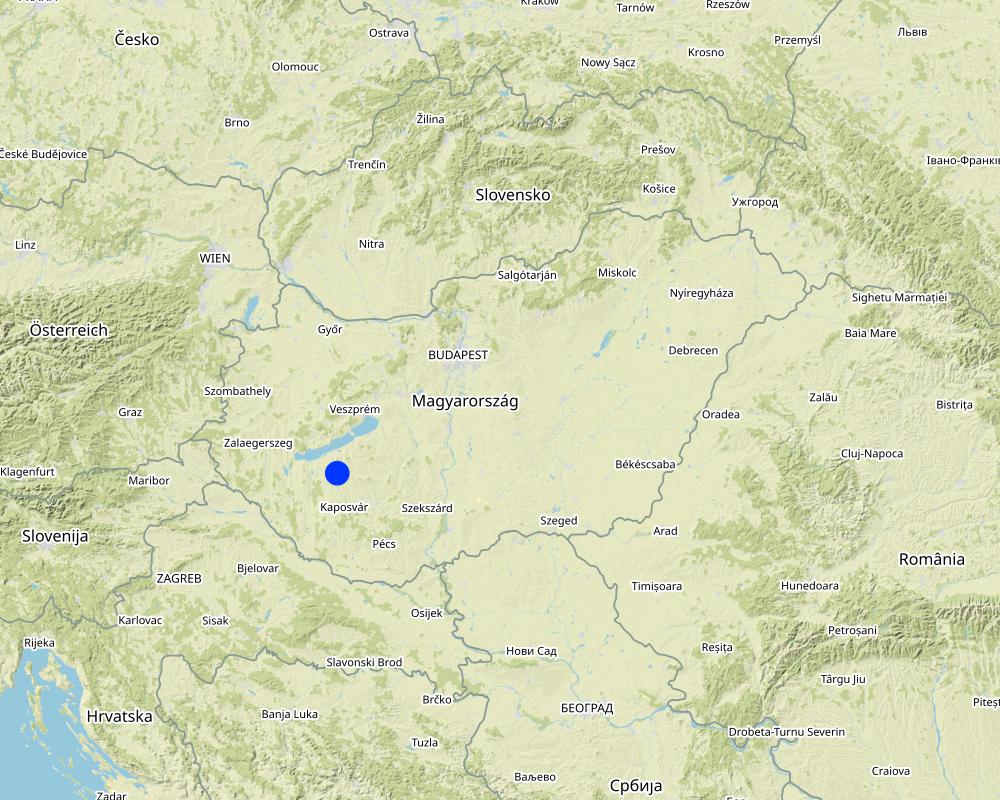
Map
×2.6 Date of implementation
Indicate year of implementation:
2012
2.7 Introduction of the Technology
Specify how the Technology was introduced:
- through land users' innovation
3. Classification of the SLM Technology
3.1 Main purpose(s) of the Technology
- reduce, prevent, restore land degradation
- create beneficial economic impact
3.2 Current land use type(s) where the Technology is applied

Cropland
- Annual cropping
Annual cropping - Specify crops:
- cereals - barley
- cereals - maize
- cereals - wheat (winter)
- oilseed crops - sunflower, rapeseed, other
Number of growing seasons per year:
- 1
Is intercropping practiced?
Yes
If yes, specify which crops are intercropped:
cover crops
Is crop rotation practiced?
Yes
If yes, specify:
winter wheat - maize - spring barley, oilseed rape
3.3 Has land use changed due to the implementation of the Technology?
Has land use changed due to the implementation of the Technology?
- No (Continue with question 3.4)
Land use mixed within the same land unit:
No
3.4 Water supply
Water supply for the land on which the Technology is applied:
- rainfed
Comments:
distribution of raifall is uneven
3.5 SLM group to which the Technology belongs
- minimal soil disturbance
- energy efficiency technologies
- soil conservation
3.6 SLM measures comprising the Technology

agronomic measures
- A3: Soil surface treatment
- A7: Others
A3: Differentiate tillage systems:
A 3.1: No tillage
3.7 Main types of land degradation addressed by the Technology

soil erosion by water
- Wt: loss of topsoil/ surface erosion

other
Specify:
soil compaction
3.8 Prevention, reduction, or restoration of land degradation
Specify the goal of the Technology with regard to land degradation:
- prevent land degradation
- restore/ rehabilitate severely degraded land
4. Technical specifications, implementation activities, inputs, and costs
4.1 Technical drawing of the Technology
Technical specifications (related to technical drawing):
To adapt technology a real-time kinematic positioning (RTK) system has to be embedded into the machinery (both tractor and machine) providing accurate (accuracy: 1-2 cm) navigation within the field.
Author:
Piroska Kassai
4.2 General information regarding the calculation of inputs and costs
Specify how costs and inputs were calculated:
- per Technology area
Indicate size and area unit:
ha
Specify currency used for cost calculations:
- USD
Indicate average wage cost of hired labour per day:
50
4.3 Establishment activities
| Activity | Timing (season) | |
|---|---|---|
| 1. | Implementing RTK Navigation System into machinery |
Comments:
RTK navigation equipment, connectors (buses), subscription for signal
4.4 Costs and inputs needed for establishment
| Specify input | Unit | Quantity | Costs per Unit | Total costs per input | % of costs borne by land users | |
|---|---|---|---|---|---|---|
| Equipment | RTK navigation equipment | pcs | 1.0 | 9500.0 | 9500.0 | 100.0 |
| Equipment | connectors (buses) | pcs | 1.0 | 1200.0 | 1200.0 | 100.0 |
| Other | subscription for RTK signal | year | 1.0 | 1200.0 | 1200.0 | 100.0 |
| Total costs for establishment of the Technology | 11900.0 | |||||
| Total costs for establishment of the Technology in USD | 11900.0 | |||||
Comments:
In the calculated cost the market prices of the equipments were taken into account not the hiring costs.
4.5 Maintenance/ recurrent activities
Comments:
no maintanance is needed
4.6 Costs and inputs needed for maintenance/ recurrent activities (per year)
Comments:
no maintenance is needed
4.7 Most important factors affecting the costs
Describe the most determinate factors affecting the costs:
Reduce compaction on the field, reducing overlapping during application of field work results in saving expenses (by ca. 10-20 %)
5. Natural and human environment
5.1 Climate
Annual rainfall
- < 250 mm
- 251-500 mm
- 501-750 mm
- 751-1,000 mm
- 1,001-1,500 mm
- 1,501-2,000 mm
- 2,001-3,000 mm
- 3,001-4,000 mm
- > 4,000 mm
Specify average annual rainfall (if known), in mm:
653.00
Specifications/ comments on rainfall:
distribution of rainfall is uneven
Indicate the name of the reference meteorological station considered:
Keszthely meteorological station
Agro-climatic zone
- sub-humid
Heathwaves often occur during summertime
5.2 Topography
Slopes on average:
- flat (0-2%)
- gentle (3-5%)
- moderate (6-10%)
- rolling (11-15%)
- hilly (16-30%)
- steep (31-60%)
- very steep (>60%)
Landforms:
- plateau/plains
- ridges
- mountain slopes
- hill slopes
- footslopes
- valley floors
Altitudinal zone:
- 0-100 m a.s.l.
- 101-500 m a.s.l.
- 501-1,000 m a.s.l.
- 1,001-1,500 m a.s.l.
- 1,501-2,000 m a.s.l.
- 2,001-2,500 m a.s.l.
- 2,501-3,000 m a.s.l.
- 3,001-4,000 m a.s.l.
- > 4,000 m a.s.l.
Indicate if the Technology is specifically applied in:
- convex situations
Comments and further specifications on topography:
both convex and concave situations within field
5.3 Soils
Soil depth on average:
- very shallow (0-20 cm)
- shallow (21-50 cm)
- moderately deep (51-80 cm)
- deep (81-120 cm)
- very deep (> 120 cm)
Soil texture (topsoil):
- medium (loamy, silty)
Soil texture (> 20 cm below surface):
- medium (loamy, silty)
Topsoil organic matter:
- medium (1-3%)
If available, attach full soil description or specify the available information, e.g. soil type, soil PH/ acidity, Cation Exchange Capacity, nitrogen, salinity etc.
Brown Earth (Luvisol), eroded, pH 6,4, no salinity
5.4 Water availability and quality
Ground water table:
< 5 m
Availability of surface water:
medium
Water quality (untreated):
poor drinking water (treatment required)
Water quality refers to:
surface water
Is water salinity a problem?
No
Is flooding of the area occurring?
No
5.5 Biodiversity
Species diversity:
- medium
Habitat diversity:
- high
Comments and further specifications on biodiversity:
arable, grass and forest are mixed in the landscape
5.6 Characteristics of land users applying the Technology
Sedentary or nomadic:
- Sedentary
Market orientation of production system:
- commercial/ market
Off-farm income:
- less than 10% of all income
Relative level of wealth:
- average
Individuals or groups:
- individual/ household
Level of mechanization:
- mechanized/ motorized
Gender:
- men
Age of land users:
- middle-aged
Indicate other relevant characteristics of the land users:
wife also works for farm business management
5.7 Average area of land used by land users applying the Technology
- < 0.5 ha
- 0.5-1 ha
- 1-2 ha
- 2-5 ha
- 5-15 ha
- 15-50 ha
- 50-100 ha
- 100-500 ha
- 500-1,000 ha
- 1,000-10,000 ha
- > 10,000 ha
Is this considered small-, medium- or large-scale (referring to local context)?
- medium-scale
- large-scale
5.8 Land ownership, land use rights, and water use rights
Land ownership:
- individual, not titled
- individual, titled
Land use rights:
- leased
- individual
Water use rights:
- communal (organized)
Are land use rights based on a traditional legal system?
Yes
5.9 Access to services and infrastructure
health:
- poor
- moderate
- good
education:
- poor
- moderate
- good
technical assistance:
- poor
- moderate
- good
employment (e.g. off-farm):
- poor
- moderate
- good
markets:
- poor
- moderate
- good
energy:
- poor
- moderate
- good
roads and transport:
- poor
- moderate
- good
drinking water and sanitation:
- poor
- moderate
- good
financial services:
- poor
- moderate
- good
6. Impacts and concluding statements
6.1 On-site impacts the Technology has shown
Socio-economic impacts
Income and costs
expenses on agricultural inputs
Quantity before SLM:
100%
Quantity after SLM:
80%
Comments/ specify:
less fertilizer, pesticide, labour and fuel
workload
Ecological impacts
Water cycle/ runoff
excess water drainage
Quantity before SLM:
100%
Quantity after SLM:
120%
Comments/ specify:
This technology increases the infiltration of water into the soil.
Soil
soil moisture
Comments/ specify:
Soil moisture increases due to the better infiltration.
soil loss
soil compaction
Comments/ specify:
One of the main benefit of this technology is that soil compaction significantly reduces.
Biodiversity: vegetation, animals
beneficial species
Comments/ specify:
soil biota increased
Other ecological impacts
less pesticides and fertilizers are used due to the precise connections of treatment strips
Quantity before SLM:
100%
Quantity after SLM:
80%
6.2 Off-site impacts the Technology has shown
damage on neighbours' fields
less pesticides
6.3 Exposure and sensitivity of the Technology to gradual climate change and climate-related extremes/ disasters (as perceived by land users)
Gradual climate change
Gradual climate change
| Season | increase or decrease | How does the Technology cope with it? | |
|---|---|---|---|
| annual temperature | increase | ||
| annual rainfall | decrease |
Climate-related extremes (disasters)
Climatological disasters
| How does the Technology cope with it? | |
|---|---|
| drought | moderately |
6.4 Cost-benefit analysis
How do the benefits compare with the establishment costs (from land users’ perspective)?
Short-term returns:
neutral/ balanced
Long-term returns:
positive
How do the benefits compare with the maintenance/ recurrent costs (from land users' perspective)?
Short-term returns:
neutral/ balanced
Long-term returns:
positive
6.5 Adoption of the Technology
- 1-10%
Of all those who have adopted the Technology, how many did so spontaneously, i.e. without receiving any material incentives/ payments?
- 51-90%
6.6 Adaptation
Has the Technology been modified recently to adapt to changing conditions?
No
6.7 Strengths/ advantages/ opportunities of the Technology
| Strengths/ advantages/ opportunities in the land user’s view |
|---|
| less input material is used |
| less compaction |
| better water infiltration |
| Strengths/ advantages/ opportunities in the compiler’s or other key resource person’s view |
|---|
| less environmental pollution |
6.8 Weaknesses/ disadvantages/ risks of the Technology and ways of overcoming them
| Weaknesses/ disadvantages/ risks in the land user’s view | How can they be overcome? |
|---|---|
| implementation of technology needs investment | economical turnover is rapid |
7. References and links
7.1 Methods/ sources of information
- interviews with land users
5
When were the data compiled (in the field)?
13/10/2022
7.2 References to available publications
Title, author, year, ISBN:
CONTROLLED TRAFFIC FARMING TECHNICAL MANUAL, Isbister, B. et al., 2013, Department of Agriculture and food, Western Australia, ISBN: 978-0-9923323-03
Available from where? Costs?
available online free of charge: https://www.nacc.com.au/wp-content/uploads/2015/05/NACC_Controlled_Traffic_Farming_Technical_Manual.pdf
7.3 Links to relevant online information
Title/ description:
Developing a controlled traffic (tramline) farming system
URL:
https://www.agric.wa.gov.au/soil-compaction/developing-controlled-traffic-tramline-farming-system
7.4 General comments
overarching, detailed
Links and modules
Expand all Collapse allLinks
Conservation tillage [Hungary]
Non inversion, conservation (soil and water protective) tillage.
- Compiler: Adam Kertesz
Modules
No modules