Contour tillage [Tunisia]
- Creation:
- Update:
- Compiler: Wafa Saidi
- Editors: Siagbé Golli, Faouzi Harrouchi, faouzi BATTI, Fatma Maaloul, Tabitha Nekesa, Ahmadou Gaye
- Reviewers: William Critchley, Rima Mekdaschi Studer
technologies_6663 - Tunisia
View sections
Expand all Collapse all1. General information
1.2 Contact details of resource persons and institutions involved in the assessment and documentation of the Technology
Name of project which facilitated the documentation/ evaluation of the Technology (if relevant)
Soil protection and rehabilitation for food security (ProSo(i)l)Name of the institution(s) which facilitated the documentation/ evaluation of the Technology (if relevant)
Direction Générale de l’Amenagement et de Conservation des Terres Agricoles (DG/ACTA) - TunisiaName of the institution(s) which facilitated the documentation/ evaluation of the Technology (if relevant)
GIZ Tunisia (GIZ Tunisia) - Tunisia1.3 Conditions regarding the use of data documented through WOCAT
The compiler and key resource person(s) accept the conditions regarding the use of data documented through WOCAT:
Yes
1.4 Declaration on sustainability of the described Technology
Is the Technology described here problematic with regard to land degradation, so that it cannot be declared a sustainable land management technology?
No
1.5 Reference to Questionnaire(s) on SLM Approaches (documented using WOCAT)
Territorial Natural Resource Management Observatory [Tunisia]
A territorial natural resources management observatory is a scientific, technical and institutional system set up in a given area to observe, monitor and improve knowledge.
- Compiler: Wafa Saidi
Integrated Territorial Planning and Development Project (PADIT) [Tunisia]
The PADIT approach comprises a cross-cutting participatory methodology to rural development, rallying various stakeholders around a project, within a location, to identify the main economic areas of the rural community concerned, and draw up a prioritized list of actions to strengthen and support development efforts in their location.
- Compiler: Wafa Saidi
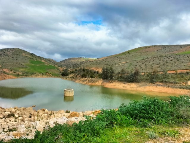
Exploitation of hillside lakes [Tunisia]
Hill lake development is an approach designed to integrate land and water management with socio-economic development.
- Compiler: Wafa Saidi
2. Description of the SLM Technology
2.1 Short description of the Technology
Definition of the Technology:
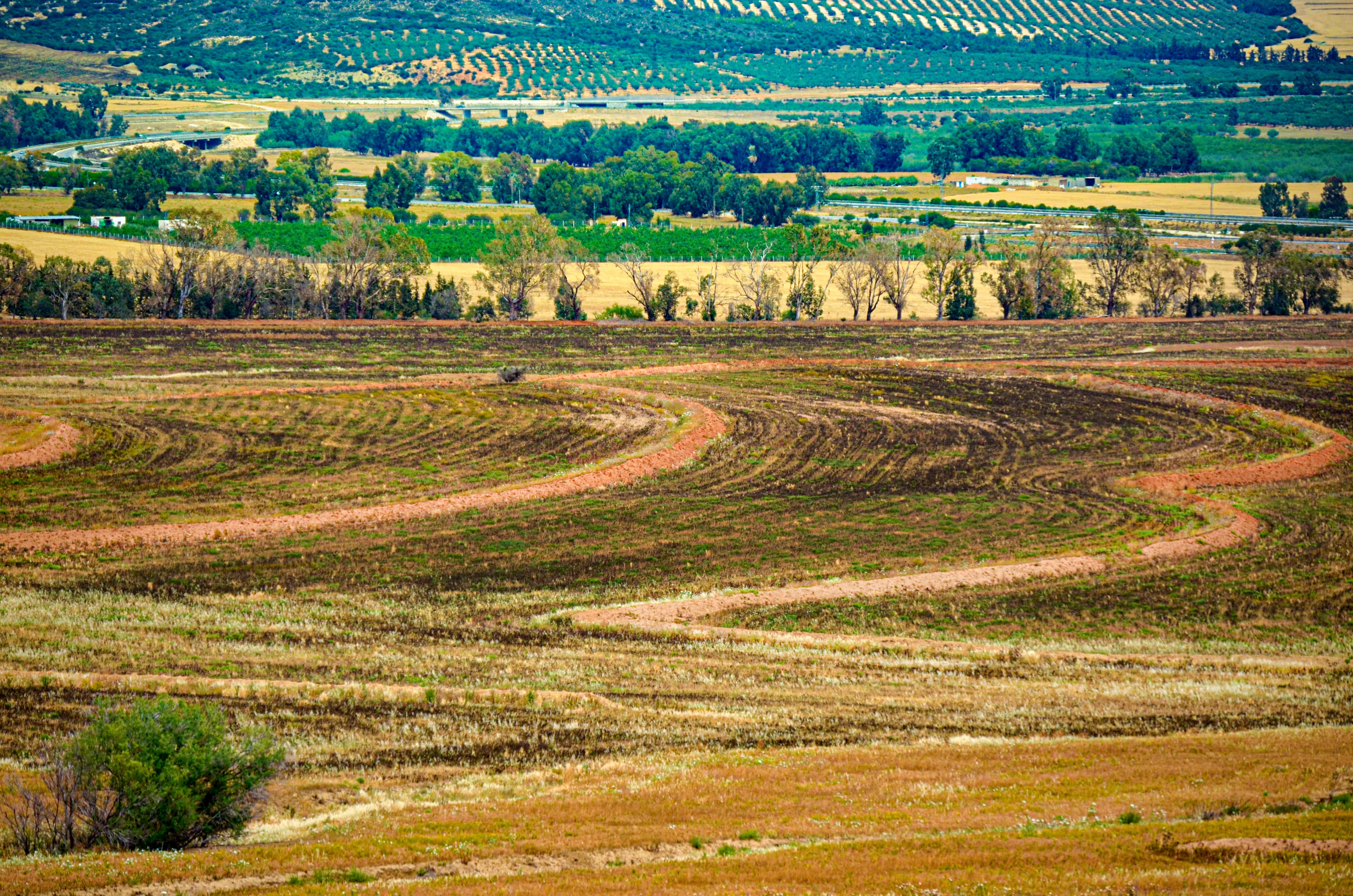
Contour ploughing is an agricultural technique involving the cultivation of sloping land along contour lines. This technique creates a succession of closely spaced ridges and furrows which help to retain water and soil.
2.2 Detailed description of the Technology
Description:
Contour ploughing, as a conservation technique, helps prevent soil erosion by slowing the flow of water across the field, which in turn helps retain soil moisture, prevent nutrient runoff and preserve soil quality. This technique is effective on slopes of less than 8% and in all agroclimatic zones. The first step in contour ploughing is to survey contour lines. "Master contour lines" are established at a distance of 7 to 15 m from each other, depending on the slope, and ploughing is executed parallel to these lines. The direction of ploughing is changed each year to avoid the formation of deep dead furrows and overly raised ridges. Land users appreciate contour ploughing for its effectiveness in preventing soil erosion and improving crop yields. However, some farmers find it difficult to establish and maintain the technology, especially in areas characterized by steep slopes or uneven terrain.
2.3 Photos of the Technology
Media Gallery
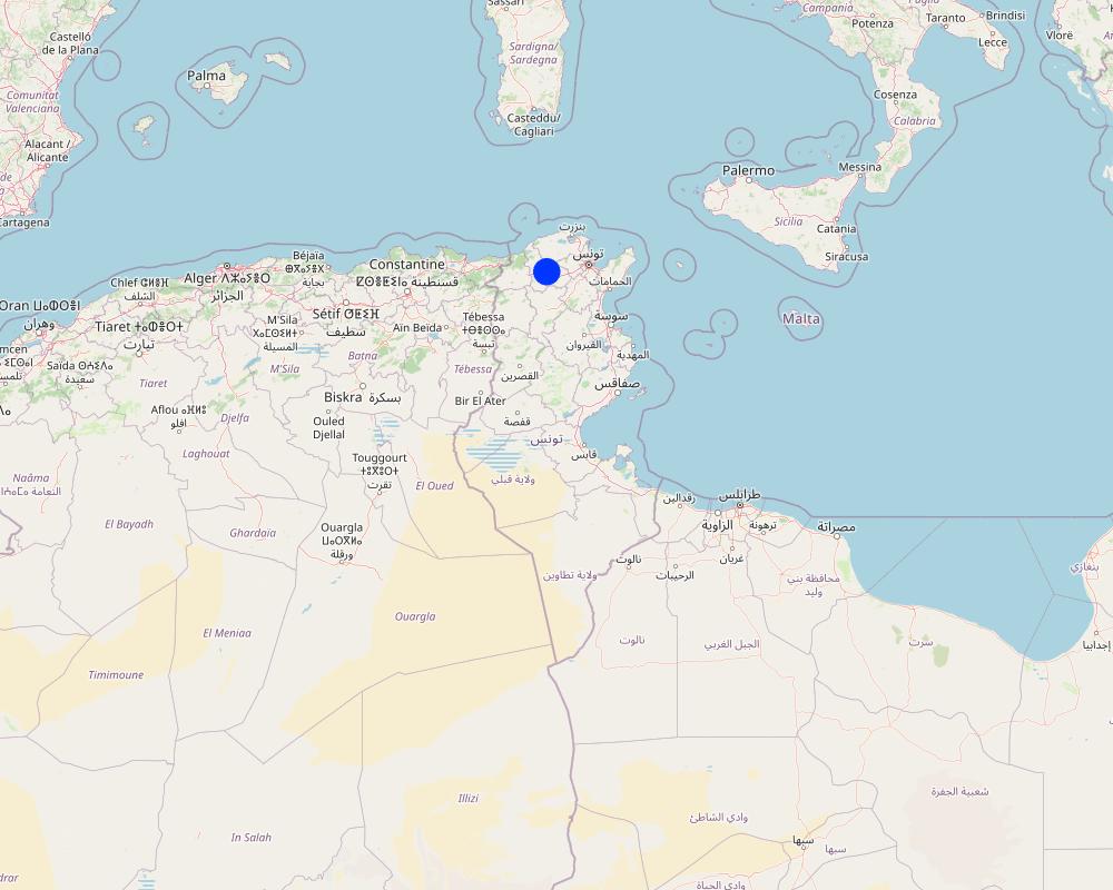
2.5 Country/ region/ locations where the Technology has been applied and which are covered by this assessment
Country:
Tunisia
Region/ State/ Province:
Beja
Further specification of location:
Mjez El Bab
Specify the spread of the Technology:
- evenly spread over an area
If precise area is not known, indicate approximate area covered:
- > 10,000 km2
Is/are the technology site(s) located in a permanently protected area?
No
Map
×2.6 Date of implementation
If precise year is not known, indicate approximate date:
- more than 50 years ago (traditional)
2.7 Introduction of the Technology
Specify how the Technology was introduced:
- as part of a traditional system (> 50 years)
Comments (type of project, etc.):
Contour ploughing is a longstanding tradition in Tunisia, where it has been employed for centuries as a method to counteract soil erosion and enhance crop yields. In recent years, there has been renewed interest in the use of contour ploughing as a sustainable agricultural practice that can help conserve soil and water resources.
3. Classification of the SLM Technology
3.1 Main purpose(s) of the Technology
- improve production
- reduce, prevent, restore land degradation
- conserve ecosystem
- preserve/ improve biodiversity
- create beneficial economic impact
3.2 Current land use type(s) where the Technology is applied
Land use mixed within the same land unit:
No

Cropland
- Annual cropping
Annual cropping - Specify crops:
- fodder crops - other
Annual cropping system:
Wheat or similar rotation with hay/pasture
Number of growing seasons per year:
- 1
Is intercropping practiced?
Yes
If yes, specify which crops are intercropped:
Fenugreek, Vetch
3.3 Has land use changed due to the implementation of the Technology?
Has land use changed due to the implementation of the Technology?
- No (Continue with question 3.4)
3.4 Water supply
Water supply for the land on which the Technology is applied:
- rainfed
3.5 SLM group to which the Technology belongs
- improved ground/ vegetation cover
- cross-slope measure
3.6 SLM measures comprising the Technology

agronomic measures
- A1: Vegetation/ soil cover
- A2: Organic matter/ soil fertility
- A3: Soil surface treatment
A3: Differentiate tillage systems:
A 3.3: Full tillage (< 30% soil cover)

vegetative measures
- V1: Tree and shrub cover
- V2: Grasses and perennial herbaceous plants
3.7 Main types of land degradation addressed by the Technology

soil erosion by water
- Wt: loss of topsoil/ surface erosion
- Wg: gully erosion/ gullying

chemical soil deterioration
- Cn: fertility decline and reduced organic matter content (not caused by erosion)
3.8 Prevention, reduction, or restoration of land degradation
Specify the goal of the Technology with regard to land degradation:
- reduce land degradation
4. Technical specifications, implementation activities, inputs, and costs
4.1 Technical drawing of the Technology
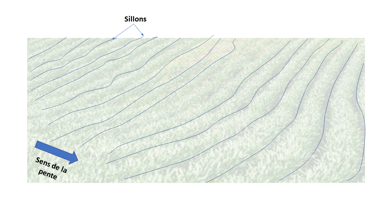
Technical specifications (related to technical drawing):
- Draw master contour lines 10 m apart. They are used as reference points when plowing.
Author:
Wafa SAIDI
Date:
04/2023
4.2 General information regarding the calculation of inputs and costs
Specify how costs and inputs were calculated:
- per Technology area
Indicate size and area unit:
1 ha
other/ national currency (specify):
Tunisian dinars
If relevant, indicate exchange rate from USD to local currency (e.g. 1 USD = 79.9 Brazilian Real): 1 USD =:
3.1
Indicate average wage cost of hired labour per day:
20
4.3 Establishment activities
| Activity | Timing (season) | |
|---|---|---|
| 1. | Surveying contour lines | This activity takes place during the dry season. |
| 2. | Plowing furrows along contour lines using a moldboard or disc plow. | Before the start of the rainy season |
Comments:
The timing of implementation activities may vary according to local conditions, such as climate, soil type and rainfall patterns.
4.4 Costs and inputs needed for establishment
If you are unable to break down the costs in the table above, give an estimation of the total costs of establishing the Technology:
150.0
4.5 Maintenance/ recurrent activities
| Activity | Timing/ frequency | |
|---|---|---|
| 1. | Plowing furrows along contour lines using a moldboard or disc plow | Before the beginning of the rainy season |
Comments:
The timing of implementation activities may vary according to local conditions, such as climate, soil type and rainfall patterns.
4.6 Costs and inputs needed for maintenance/ recurrent activities (per year)
If you are unable to break down the costs in the table above, give an estimation of the total costs of maintaining the Technology:
150.0
4.7 Most important factors affecting the costs
Describe the most determinate factors affecting the costs:
Equipment and fuel costs
5. Natural and human environment
5.1 Climate
Annual rainfall
- < 250 mm
- 251-500 mm
- 501-750 mm
- 751-1,000 mm
- 1,001-1,500 mm
- 1,501-2,000 mm
- 2,001-3,000 mm
- 3,001-4,000 mm
- > 4,000 mm
Specifications/ comments on rainfall:
The region experiences highly erratic rainfall patterns from year to year, with several consecutive dry years being a common occurrence, creating uncertainty in the harvesting of field crops. The rainiest months are February, October and November.
Indicate the name of the reference meteorological station considered:
Mjez El Beb CTV
Agro-climatic zone
- semi-arid
The governorate of Béja has an average annual temperature of approximately 18°C. Summers are characterized by hot weather, with average temperatures generally exceeding 25°C. High temperatures typically range between 27 and 32°C. Winters are relatively mild, with average temperatures ranging from 10 to 12°C. Low temperatures during winter average between 5 and 7°C.
5.2 Topography
Slopes on average:
- flat (0-2%)
- gentle (3-5%)
- moderate (6-10%)
- rolling (11-15%)
- hilly (16-30%)
- steep (31-60%)
- very steep (>60%)
Landforms:
- plateau/plains
- ridges
- mountain slopes
- hill slopes
- footslopes
- valley floors
Altitudinal zone:
- 0-100 m a.s.l.
- 101-500 m a.s.l.
- 501-1,000 m a.s.l.
- 1,001-1,500 m a.s.l.
- 1,501-2,000 m a.s.l.
- 2,001-2,500 m a.s.l.
- 2,501-3,000 m a.s.l.
- 3,001-4,000 m a.s.l.
- > 4,000 m a.s.l.
Indicate if the Technology is specifically applied in:
- not relevant
5.3 Soils
Soil depth on average:
- very shallow (0-20 cm)
- shallow (21-50 cm)
- moderately deep (51-80 cm)
- deep (81-120 cm)
- very deep (> 120 cm)
Soil texture (topsoil):
- medium (loamy, silty)
- fine/ heavy (clay)
Soil texture (> 20 cm below surface):
- medium (loamy, silty)
- fine/ heavy (clay)
Topsoil organic matter:
- medium (1-3%)
If available, attach full soil description or specify the available information, e.g. soil type, soil PH/ acidity, Cation Exchange Capacity, nitrogen, salinity etc.
Organic carbon in topsoil (wt.%): 0.65
Topsoil pH (H2O): 6.9
Topsoil calcium carbonate (wt.%): 0.4
Topsoil sodicity (ESP) (%): 2
Topsoil salinity (ECe) (dS/m): 2.7
Subsoil organic carbon (wt.%): 0.27
Subsoil pH (H2O): 7.3
Subsoil calcium carbonate (wt.%): 1.7
Subsoil sodicity (ESP) (%): 2
Subsoil salinity (ECe) (dS/m): 1.7
5.4 Water availability and quality
Ground water table:
> 50 m
Availability of surface water:
good
Water quality (untreated):
poor drinking water (treatment required)
Water quality refers to:
both ground and surface water
Is water salinity a problem?
No
Is flooding of the area occurring?
Yes
Regularity:
episodically
5.5 Biodiversity
Species diversity:
- medium
Habitat diversity:
- medium
5.6 Characteristics of land users applying the Technology
Sedentary or nomadic:
- Sedentary
Market orientation of production system:
- mixed (subsistence/ commercial)
Off-farm income:
- 10-50% of all income
Relative level of wealth:
- rich
Individuals or groups:
- individual/ household
Level of mechanization:
- mechanized/ motorized
Gender:
- men
Age of land users:
- youth
5.7 Average area of land used by land users applying the Technology
- < 0.5 ha
- 0.5-1 ha
- 1-2 ha
- 2-5 ha
- 5-15 ha
- 15-50 ha
- 50-100 ha
- 100-500 ha
- 500-1,000 ha
- 1,000-10,000 ha
- > 10,000 ha
Is this considered small-, medium- or large-scale (referring to local context)?
- large-scale
5.8 Land ownership, land use rights, and water use rights
Land ownership:
- individual, titled
Land use rights:
- individual
Water use rights:
- individual
Are land use rights based on a traditional legal system?
No
5.9 Access to services and infrastructure
health:
- poor
- moderate
- good
education:
- poor
- moderate
- good
technical assistance:
- poor
- moderate
- good
employment (e.g. off-farm):
- poor
- moderate
- good
markets:
- poor
- moderate
- good
energy:
- poor
- moderate
- good
roads and transport:
- poor
- moderate
- good
drinking water and sanitation:
- poor
- moderate
- good
financial services:
- poor
- moderate
- good
6. Impacts and concluding statements
6.1 On-site impacts the Technology has shown
Socio-economic impacts
Production
crop production
Comments/ specify:
A 30% increase in yields
crop quality
risk of production failure
Income and costs
farm income
workload
Comments/ specify:
Contour plowing requires more time to complete.
Socio-cultural impacts
food security/ self-sufficiency
Ecological impacts
Water cycle/ runoff
harvesting/ collection of water
Quantity before SLM:
0%
Quantity after SLM:
25%
surface runoff
Soil
soil moisture
soil cover
soil loss
soil accumulation
Biodiversity: vegetation, animals
Vegetation cover
biomass/ above ground C
plant diversity
Climate and disaster risk reduction
flood impacts
Specify assessment of on-site impacts (measurements):
On-site impact assessment is based on estimates and observations made by the farmer.
6.2 Off-site impacts the Technology has shown
downstream siltation
Specify assessment of off-site impacts (measurements):
The assessment of external impacts is based on experts' observations.
6.3 Exposure and sensitivity of the Technology to gradual climate change and climate-related extremes/ disasters (as perceived by land users)
Gradual climate change
Gradual climate change
| Season | increase or decrease | How does the Technology cope with it? | |
|---|---|---|---|
| annual rainfall | decrease | very well |
Climate-related extremes (disasters)
Meteorological disasters
| How does the Technology cope with it? | |
|---|---|
| local rainstorm | well |
6.4 Cost-benefit analysis
How do the benefits compare with the establishment costs (from land users’ perspective)?
Short-term returns:
very positive
Long-term returns:
positive
How do the benefits compare with the maintenance/ recurrent costs (from land users' perspective)?
Short-term returns:
very positive
Long-term returns:
positive
6.5 Adoption of the Technology
- > 50%
Of all those who have adopted the Technology, how many did so spontaneously, i.e. without receiving any material incentives/ payments?
- 51-90%
6.6 Adaptation
Has the Technology been modified recently to adapt to changing conditions?
No
6.7 Strengths/ advantages/ opportunities of the Technology
| Strengths/ advantages/ opportunities in the land user’s view |
|---|
| Increase crop yields |
| Improve soil fertility |
| Reduce erosion |
| Strengths/ advantages/ opportunities in the compiler’s or other key resource person’s view |
|---|
| Enhance biodiversity |
6.8 Weaknesses/ disadvantages/ risks of the Technology and ways of overcoming them
| Weaknesses/ disadvantages/ risks in the land user’s view | How can they be overcome? |
|---|---|
| Contour plowing requires more time than conventional plowing, which may discourage some farmers from adopting the technique. | Raising farmers' awareness of the advantages of this technique |
| Weaknesses/ disadvantages/ risks in the compiler’s or other key resource person’s view | How can they be overcome? |
|---|---|
| Parceling out of lands | Land reform through land consolidation |
7. References and links
7.1 Methods/ sources of information
- field visits, field surveys
A field survey was conducted.
- interviews with land users
A farmer was interviewed.
- interviews with SLM specialists/ experts
- compilation from reports and other existing documentation
When were the data compiled (in the field)?
04/02/2023
7.2 References to available publications
Title, author, year, ISBN:
Guide de conservation des eaux et du Sol, Ministère de l’agriculture, Direction Générale de l'Aménagement et de la Conservations des Terres Agricoles, 1995: Ministère de l’agriculture, Direction Générale de l'Aménagement et de la Conservations des Terres Agricoles
Available from where? Costs?
Ministry of Agriculture, Directorate-General for the Development and Conservation of Agricultural Lands
Title, author, year, ISBN:
Carte agricole de la Tunisie, Ministère de l’agriculture, 2005
Available from where? Costs?
Ministry of Agriculture, Directorate-General for the Development and Conservation of Agricultural Lands
7.3 Links to relevant online information
Title/ description:
Guide technique pour la lutte contre la désertification, Abdessalem Kallala, OSS, 2017
URL:
http://projet.oss-online.org/LCD/images/BP/Techniques_LCD.pdf
Title/ description:
Guide des bonnes pratiques d'utilisation durable de l'eau et des terres, WWF, 2019
URL:
https://www.wwf.ma/nos_nouvelles/nospublications/?33164/Guide-des-bonnes-pratiques-dutilisation-durable-de-leau-et-des-terres
Title/ description:
Harmonized World Soil Database, FAO, 2009
URL:
https://www.fao.org/soils-portal/data-hub/soil-maps-and-databases/harmonized-world-soil-database-v12/en/
Links and modules
Expand all Collapse allLinks
Territorial Natural Resource Management Observatory [Tunisia]
A territorial natural resources management observatory is a scientific, technical and institutional system set up in a given area to observe, monitor and improve knowledge.
- Compiler: Wafa Saidi
Integrated Territorial Planning and Development Project (PADIT) [Tunisia]
The PADIT approach comprises a cross-cutting participatory methodology to rural development, rallying various stakeholders around a project, within a location, to identify the main economic areas of the rural community concerned, and draw up a prioritized list of actions to strengthen and support development efforts in their location.
- Compiler: Wafa Saidi
Exploitation of hillside lakes [Tunisia]
Hill lake development is an approach designed to integrate land and water management with socio-economic development.
- Compiler: Wafa Saidi
Modules
No modules