Contour bunds for crops and forest/rangeland [Níger]
- Creación:
- Actualización:
- Compilador: Dieter Nill
- Editor: –
- Revisores: Deborah Niggli, David Streiff, Alexandra Gavilano
Banquettes agricoles et sylvo-pastorales (French)
technologies_1652 - Níger
Visualizar secciones
Expandir todo Colapsar todos1. Información general
1.2 Detalles de contacto de las personas de referencia e instituciones involucradas en la evaluación y la documentación de la Tecnología
Especialista MST:
Mamadou Abdou Gaoh Sani
Programme d’Appui à l’agriculture Productive (PROMAP)
Níger
Especialista MST:
Dorlöchter-Sulser Sabine
Misereor
Alemania
Nombre del proyecto que financió la documentación/ evaluación de la Tecnología (si fuera relevante)
Programme d’Appui à l’agriculture Productive (GIZ / PROMAP)Nombre del proyecto que financió la documentación/ evaluación de la Tecnología (si fuera relevante)
Manual of Good Practices in Small Scale Irrigation in the Sahel (GIZ )Nombre de la(s) institución(es) que facilitaron la documentación/ evaluación de la Tecnología (si fuera relevante)
Deutsche Gesellschaft für Internationale Zusammenarbeit (GIZ) - AlemaniaNombre de la(s) institución(es) que facilitaron la documentación/ evaluación de la Tecnología (si fuera relevante)
Misereor - Alemania1.3 Condiciones referidas al uso de datos documentados mediante WOCAT
El compilador y la/s persona(s) de referencia claves aceptan las condiciones acerca del uso de los datos documentados mediante WOCAT:
Sí
1.4 Declaración de la sostenibilidad de la Tecnología descrita
¿La Tecnología aquí descrita resulta problemática en relación a la degradación de la tierra, de tal forma que no puede considerársela una tecnología sostenible para el manejo de la tierra?
No
2. Descripción de la Tecnología MST
2.1 Breve descripción de la Tecnología
Definición de la Tecnología:
Contour bunds, built with earth or stones, increase the amount of water available to crops and vegetation, thus contributing to the restoration of degraded land
2.2 Descripción detallada de la Tecnología
Descripción:
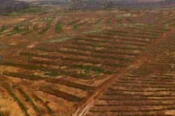
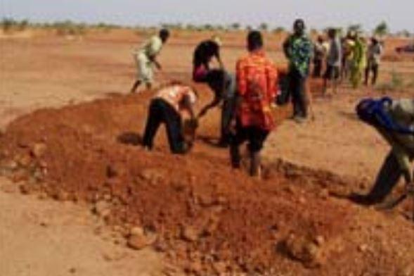
A contour bund is a rectangular structure consisting of bunds built with earth or stone or a combination of both, which can be permeable or impermeable. The bottom bund is up to 80 m long, and the wingwalls extend up to 15 m upslope. The contour bunds are built in staggered rows along the natural contour of the land with the open end facing uphill. Patches in the same row are spaced 6 m apart, and the rows are positioned about 25 m apart, depending of the gradient of the slope. Downslope of the structure, a water collection ditch 0.50 m wide and 0.30 m deep is dug. The earth excavated from the ditch is piled up and compacted to construct the main bund. When used for growing crops, a third of the total surface area inside the contour bunds is loosened by subsoiling. The remaining two thirds of the surface are left unworked and serve as a catchment area. This doubles or triples the volume of water available to crops. Trees are planted along the main bund to stabilise the structure.
Contour bunds for forest/rangeland work as contour bunds on cropland (described above), except that the sizing is slightly different. The main bund of patches used for this purpose is up to 100 m long and the rows are spaced up to 30 m apart.
In Niger, contour bunds for forest/rangeland are used to restore land in plateau areas which have been completely degraded and denuded by severe water and wind erosion. Contour bunds for growing crops are recommended for the restoration of pediments, particularly in areas where land use pressure is high. The technique is recommended for areas with a low gradient and rainfall of less than 600 mm.
The bunds capture and retain runoff for several days. Infiltration of the water into the soil increases, and there is a gradual build-up of sediment behind the bunds, creating favourable conditions for the establishment of vegetation. Contour bunds for crops increase the area of land that can be farmed and its productivity thanks to their capacity to retain runoff and the shelter provided by trees planted along the bottom bund, which protects the crops. An advantage from the perspective of watershed development is that contour bunds constructed on plateaux areas protect areas downstream against heavy runoff.
Before constructing the contour bunds, it is essential to clarify the ownership status of the land where the measures are to be implemented and who the users will be, with a view to avoiding disputes later on.
When constructing the contour bunds, it is important to mark out the contour lines correctly and ensure that the earth is firmly compacted.
With some upkeep, stone or stone-lined contour bunds last at least 20 years. Earthen bunds do not last as long. Good vegetation cover established along the bunds increases their lifetime.
The Sahel is a region where the population has always faced a high degree of climate variability, manifested both in terms of time (unexpected dry spells can occur during the rainy season) and in terms of space (rainfall can vary greatly from one area to another). The population is mainly composed of small farmers and livestock keepers.
Over the last two decades, the effects of climate change have exacerbated the already difficult conditions. Accord¬ing to projections made by climatologists, the Sahel will experience a rise in temperatures combined with highly variable rainfall and an increase in extreme weather events.
The Soil and Water conservation and rehabilitation techniques have helped people in the Sahel to manage their ecosystems more effectively and improve their productive land. As a result, communities are better prepared to cope with environmental changes (changes in the climate, land degradation, etc.) and the im¬pact of shocks, particularly droughts.
2.3 Fotografías de la Tecnología
Galería de medios
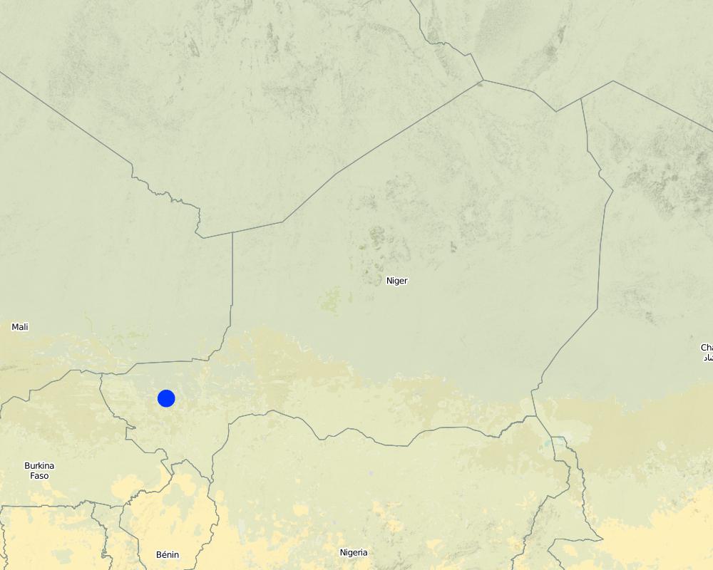
2.5 País/ región/ lugares donde la Tecnología fue aplicada y que se hallan comprendidos por esta evaluación
País:
Níger
Región/ Estado/ Provincia:
Niger
Especifique más el lugar :
Regions of Tillabéri, Filingué, Ouallam, Téra and Tahoua
Especifique la difusión de la Tecnología:
- distribuida parejamente sobre un área
Si se desconoce el área precisa, indique el área aproximada cubierta:
- 10-100 km2
Map
×2.6 Fecha de la implementación
Si no se conoce el año preciso, indique la fecha aproximada:
- 10-50 años atrás
2.7 Introducción de la Tecnología
Especifique cómo se introdujo la Tecnología:
- mediante proyectos/ intervenciones externas
Comentarios (tipo de proyecto, etc.):
Developed, implemented and disseminated as part of projects and programmes undertaken from the 1980s onwards to combat desertification and improve natural resource management. Implemented by GIZ (German Federal Enterprise for International Cooperation), PDRT (Projet de développement rural de Tahoua - Tahoua Rural Development Project), PASP (Projet de protection intégrée des ressources agro-sylvo-pastorales Tillabéri-Nord - Project for the Integrated Protection of Agricultural, Forest and Rangeland Resources in Tillabéri-Nord)
3. Clasificación de la Tecnología MST
3.1 Propósito(s) principal(es) de la Tecnología MST
- reducir, prevenir, restaurar la degradación del suelo
- adaptarse al cambio climático/ extremos climáticos y sus impactos
3.2 Tipo(s) actuales de uso de la tierra donde se aplica la Tecnología

Tierras cultivadas
- Cosecha anual
- Cosecha de árboles y arbustos
Cosechas anuales - Especifique cultivos:
- cultivos de semillas oleaginosas - maní
- cereales - mijo
- cereales - sorgo
- leguminosas y legumbres - arvejas
Cultivos de matorrales y arbustos - Especifique cultivos:
- mango, mangostán, guayaba
Número de temporadas de cultivo por año:
- 1
Especifique:
Longest growing period in days: 120; Longest growing period from month to month: August to October

Bosques
- Bosques/ zonas boscosas (semi) naturales
Bosques/ zonas boscosas (semi-) naturales: Especifique tipo de manejo:
- Tala selectiva
Productos y servicios:
- Madera
- Leña
- Frutos y nueces
- Otros productos forestales
- Pastoreo/ ramoneo
Comentarios:
major cash crop: Ground nut
major food crops: Millet
other: Sorghum, cow pea and mangoes
Major land use problems (compiler’s opinion): crusting, surface runoff, water and wind erosion, unadapted land use methods, rapidly growing population increasing pressure on land, reduced or abandoned fallow periods, insecure access to land
Type of cropping system and major crops comments: farmers are mainly agropastoralists with some communities specialised on pure pastoralism
Constraints of forested government-owned land or commons
Livestock density: 1-10 LU /km2
3.4 Provisión de agua
Provisión de agua para la tierra donde se aplica la Tecnología:
- de secano
3.5 Grupo MST al que pertenece la Tecnología
- agroforestería
- medida de pendiente transversal
3.6 Medidas MST que componen la Tecnología

medidas vegetativas
- V1: Cubierta de árboles y arbustos

medidas estructurales
- S2: Taludes, bancos
Comentarios:
Type of vegetative measures: aligned: -contour
3.7 Principales tipos de degradación del suelo encarados con la Tecnología

erosión de suelos por agua
- Wt: pérdida de capa arable/ erosión de la superficie

deterioro químico del suelo
- Cn: reducción de la fertilidad y contenido reducido de la materia orgánica del suelo (no ocasionados por la erosión)

deterioro físico del suelo
- Pc: compactación
- Pk: desmoronamiento y encostramiento

degradación biológica
- Bc: reducción de la cobertura vegetal del suelo

degradación del agua
- Ha: aridificación
Comentarios:
Main causes of degradation: soil management (Unadapted landuse methods, reduced or abandoned fallow periods), crop management (annual, perennial, tree/shrub) (Neglect of fallow periods and crop rotation), droughts (due to heat waves), population pressure (rapidly growing population increasing pressure on land), land tenure (insecure access to land and collectively managed common land), poverty / wealth (very poor population)
Secondary causes of degradation: deforestation / removal of natural vegetation (incl. forest fires) (deforestation through overgrazing and fire wood collection), over-exploitation of vegetation for domestic use (firewood collection), overgrazing (cattle, sheep and goats), change in temperature (Climate change: heat waves), change of seasonal rainfall (more variable onset of rain), Heavy / extreme rainfall (intensity/amounts) (more variable and intensive rains), wind storms / dust storms (frequent storms), floods (due to intensive rain storms), labour availability (some migration of men to nearby cities), education, access to knowledge and support services (high level of illiteracy)
3.8 Prevención, reducción o restauración de la degradación del suelo
Especifique la meta de la Tecnología con relación a la degradación de la tierra:
- restaurar/ rehabilitar tierra severamente degradada
4. Especificaciones técnicas, actividades de implementación, insumos y costos
4.1 Dibujo técnico de la Tecnología
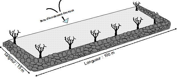
Especificaciones técnicas (relacionadas al dibujo técnico):
Technical knowledge required for field staff / advisors: moderate
Technical knowledge required for land users: low
Main technical functions: control of dispersed runoff: retain / trap, control of dispersed runoff: impede / retard, control of concentrated runoff: retain / trap, control of concentrated runoff: impede / retard, improvement of ground cover, stabilisation of soil (eg by tree roots against land slides), increase in nutrient availability (supply, recycling,…), increase of infiltration, increase / maintain water stored in soil, water harvesting / increase water supply, sediment retention / trapping, sediment harvesting, promotion of vegetation species and varieties (quality, eg palatable fodder)
Secondary technical functions: improvement of surface structure (crusting, sealing), improvement of topsoil structure (compaction), increase in organic matter, reduction in wind speed
Aligned: -contour
Vegetative material: T : trees / shrubs
Vegetation is used for stabilisation of structures.
Autor:
MDR, Niger, Recueil des fiches
4.2 Información general sobre el cálculo de insumos y costos
Especifique la moneda usada para calcular costos:
- USD
4.3 Actividades de establecimiento
| Actividad | Momento (estación) | |
|---|---|---|
| 1. | The contour bunds are built in staggered rows along the natural contour of the land with the open end facing uphill. | |
| 2. | Downslope of the structure, a water collection ditch 0.50 m wide and 0.30 m deep is dug. | |
| 3. | The earth excavated from the ditch is piled up and compacted to construct the main bund | |
| 4. | When used for growing crops, a third of the total surface area inside the contour bunds is loosened by subsoiling | |
| 5. | Trees are planted along the main bund to stabilise the structure |
4.5 Actividades de establecimiento/ recurrentes
| Actividad | Momento/ frequencia | |
|---|---|---|
| 1. | Damages caused by excessive rainfall need to be repaired quickly |
4.7 Factores más determinantes que afectan los costos:
Describa los factores más determinantes que afectan los costos:
Labour: 54 man-days per ha.
Equipment: pickaxes, shovels, wheelbarrows, water-tube level.
Other costs: hire of machine for subsoiling (1 day per ha).
5. Entorno natural y humano
5.1 Clima
Lluvia anual
- < 250 mm
- 251-500 mm
- 501-750 mm
- 751-1,000 mm
- 1,001-1,500 mm
- 1,501-2,000 mm
- 2,001-3,000 mm
- 3,001-4,000 mm
- > 4,000 mm
Zona agroclimática
- semi-árida
Thermal climate class: subtropics
5.2 Topografía
Pendientes en promedio:
- plana (0-2 %)
- ligera (3-5%)
- moderada (6-10%)
- ondulada (11-15%)
- accidentada (16-30%)
- empinada (31-60%)
- muy empinada (>60%)
Formaciones telúricas:
- meseta/ planicies
- cordilleras
- laderas montañosas
- laderas de cerro
- pies de monte
- fondo del valle
Zona altitudinal:
- 0-100 m s.n.m.
- 101-500 m s.n.m.
- 501-1,000 m s.n.m
- 1,001-1,500 m s.n.m
- 1,501-2,000 m s.n.m
- 2,001-2,500 m s.n.m
- 2,501-3,000 m s.n.m
- 3,001-4,000 m s.n.m
- > 4,000 m s.n.m
5.3 Suelos
Profundidad promedio del suelo:
- muy superficial (0-20 cm)
- superficial (21-50 cm)
- moderadamente profunda (51-80 cm)
- profunda (81-120 cm)
- muy profunda (>120 cm)
Textura del suelo (capa arable):
- mediana (limosa)
- fina/ pesada (arcilla)
Materia orgánica de capa arable:
- baja (<1%)
Si se halla disponible, adjunte una descripción completa de los suelos o especifique la información disponible, por ej., tipo de suelo, pH/ acidez de suelo, capacidad de intercambio catiónico, nitrógeno, salinidad, etc. :
Soil texture (topsoil): Fine to medium (sandy to clayey loams)
Soil fertility is very low - medium
Soil drainage / infiltration is poor - medium
Soil water storage capacity is low - medium
5.4 Disponibilidad y calidad de agua
Agua subterránea:
5-50 m
Disponibilidad de aguas superficiales:
mediana
Calidad de agua (sin tratar):
solo para uso agrícola (irrigación)
5.5 Biodiversidad
Diversidad de especies:
- baja
5.6 Las características de los usuarios de la tierra que aplican la Tecnología
Sedentario o nómada:
- Semi-nómada
Orientación del mercado del sistema de producción:
- subsistencia (autoprovisionamiento)
- mixta (subsistencia/ comercial)
Ingresos no agrarios:
- 10-50% de todo el ingreso
Nivel relativo de riqueza:
- muy pobre
- pobre
Nivel de mecanización:
- trabajo manual
- tracción animal
Género:
- hombres
Indique otras características relevantes de los usuarios de las tierras:
Population density: 10-50 persons/km2
Annual population growth: 3% - 4%
Off-farm income specification: men migrate temporarily or permanently to cities for off-farm income, women and men seasonally carry out paid farm work
Market orientation of production system: Most households crop for subsistence (mainly for small agropastoralists), but surplus is sold on market (medium agropastoralists). Commercial markets: some vegetable growing and pastoralists.
Level of mechanization: Ox and donkey for animal traction
5.7 Área promedio de la tierra usada por usuarios de tierra que aplican la Tecnología
- < 0.5 ha
- 0.5-1 ha
- 1-2 ha
- 2-5 ha
- 5-15 ha
- 15-50 ha
- 50-100 ha
- 100-500 ha
- 500-1,000 ha
- 1,000-10,000 ha
- > 10,000 ha
¿Esto se considera de pequeña, mediana o gran escala (refiriéndose al contexto local)?
- pequeña escala
5.8 Tenencia de tierra, uso de tierra y derechos de uso de agua
Tenencia de tierra:
- estado
- comunitaria/ aldea
Derechos de uso de tierra:
- acceso abierto (no organizado)
Derechos de uso de agua:
- acceso abierto (no organizado)
5.9 Acceso a servicios e infraestructura
salud:
- pobre
- moderado
- bueno
educación:
- pobre
- moderado
- bueno
asistencia técnica:
- pobre
- moderado
- bueno
empleo (ej. fuera de la granja):
- pobre
- moderado
- bueno
mercados:
- pobre
- moderado
- bueno
energía:
- pobre
- moderado
- bueno
caminos y transporte:
- pobre
- moderado
- bueno
agua potable y saneamiento:
- pobre
- moderado
- bueno
servicios financieros:
- pobre
- moderado
- bueno
6. Impactos y comentarios para concluir
6.1 Impactos in situ demostrados por la Tecnología
Impactos socioeconómicos
Producción
producción de cultivo
producción de forraje
producción animal
producción de madera
riesgo de fracaso de producción
área de producción
Disponibilidad y calidad de agua
demanda de agua para irrigar
Ingreso y costos
ingreso agrario
Impactos socioculturales
seguridad alimentaria/ autosuficiencia
MST/ conocimiento de la degradación del suelo
livelihood and human well-being
Comentarios/ especifique:
Contour bunds for crops increase the area of land that can be farmed and its productivity thanks to their capacity to retain runoff and the shelter provided by trees planted along the bottom bund, which protects the crops
Impactos ecológicos
Ciclo de agua/ escurrimiento de sedimento
cosecha/ recolección de agua
escurrimiento superficial
nivel freático/ acuífero
Suelo
humedad del suelo
cubierta del suelo
pérdida de suelo
encostramiento/ sellado de suelo
compactación de suelo
ciclo/ recarga de nutrientes
materia orgánica debajo del suelo C
Biodiversidad: vegetación, animales
biomasa/ sobre suelo C
diversidad vegetal
Reducción de riesgos de desastres y riesgos climáticos
velocidad de viento
6.2 Impactos fuera del sitio demostrados por la Tecnología
inundaciones río abajo
colmatación río abajo
6.3 Exposición y sensibilidad de la Tecnología al cambio climático gradual y a extremos relacionados al clima/ desastres (desde la percepción de los usuarios de tierras)
Cambio climático gradual
Cambio climático gradual
| Estación | Incremento o reducción | ¿Cómo es que la tecnología soporta esto? | |
|---|---|---|---|
| temperatura anual | incrementó | bien |
Extremos (desastres) relacionados al clima
Desastres climatológicos:
| ¿Cómo es que la tecnología soporta esto? | |
|---|---|
| tormenta de lluvia local | no muy bien |
| tormenta de viento | bien |
Desastres climatológicos
| ¿Cómo es que la tecnología soporta esto? | |
|---|---|
| sequía | bien |
Desastres hidrológicos
| ¿Cómo es que la tecnología soporta esto? | |
|---|---|
| inundación general (río) | no muy bien |
Otras consecuencias relacionadas al clima
Otras consecuencias relacionadas al clima
| ¿Cómo es que la tecnología soporta esto? | |
|---|---|
| periodo reducido de crecimiento | no se sabe |
Comentarios:
Physical structures can be biologically stabilized through planting of grass, bushes or trees. Damages are generally small but need to be repaired quickly.
6.4 Análisis costo-beneficio
¿Cómo se comparan los beneficios con los costos de establecimiento (desde la perspectiva de los usuarios de tierra)?
Ingresos a corto plazo:
positivo
Ingresos a largo plazo:
positivo
¿Cómo se comparan los beneficios con los costos de mantenimiento/ recurrentes (desde la perspectiva de los usuarios de tierra)?
Ingresos a corto plazo:
positivo
Ingresos a largo plazo:
positivo
6.5 Adopción de la Tecnología
De todos quienes adoptaron la Tecnología, ¿cuántos lo hicieron espontáneamente, por ej. sin recibir nada de incentivos/ materiales:
- 11-50%
Comentarios:
The techniques were implemented with food for work in the 1990s to 2000. At the end, the work provided by land users was not compensated. Only small equipment and transportation were provided for free.
50% of land user families have adopted the Technology without any external material support
There is a little trend towards spontaneous adoption of the Technology
Some adoption (without support by the project) has been observed in some places. The level of replication is however limited to locations where stones are available nearby. Otherwise transportation becomes a problem. Potential for replication depends on the type of terrain, there being a nearby supply of the materials needed (stone). Subsoiling needs mechanical treatment by tractor.
6.7 Fuerzas/ ventajas/ oportunidades de la Tecnología
| Fuerzas/ ventajas/ oportunidades desde la perspectiva del usuario de la tierra |
|---|
| Contour bunds for crops increase the area of land that can be farmed and its productivity thanks to their capacity to retain runoff and the shelter provided by trees planted along the bottom bund, which protects the crops. |
| Fuerzas/ ventajas/ oportunidades desde la perspectiva del compilador o de otra persona de referencia clave |
|---|
| In a low-rainfall scenario, the construction of contour bunds helps to restore vegetation cover on vast areas of denuded land from the first year after they are established. Infiltration of the water into the soil increases, and there is a gradual build-up of sediment behind the bunds, creating favourable conditions for the establishment of vegetation. |
| Good vegetation cover established along the bunds con- tributes to lowering soil temperature and providing pro- tection from wind erosion along the entire length of the patch. |
| The construction of contour bunds upstream of river basins reduces the risk of gully erosion and siltation downstream. |
| In Niger, it is mainly women who have benefitted from efforts to rehabilitate land on the plateaux. With the support of development projects, women were able to secure five-year leases from land owners. |
| This technique transforms unproductive land into land that is economically valuable. |
6.8 Debilidades/ desventajas/ riesgos de la Tecnología y formas de sobreponerse a ellos
| Debilidades/ desventajas/ riesgos desde la perspectiva del usuario de la tierra | ¿Cómo sobreponerse a ellas? |
|---|---|
| There are also disadvantages associated with subsoiling in the contour bunds. Although subsoiling permits rapid, relatively deep infiltration, the water is situated below the level where the roots of young crops or grasses are growing, which means that the infiltrated water is not used optimally in the initial stages. Furthermore, the surface of the subsoiled land becomes hard again after several years of cultivation, because the soil structure is broken down owing to a concentration of fine particles of earth in the grooves of the subsoil, which can clog up the pores of the soil. |
| Debilidades/ desventajas/ riesgos desde la perspectiva del compilador o de otra persona de referencia clave | ¿Cómo sobreponerse a ellas? |
|---|---|
| Patches with impermeable bunds are not appropriate when there are heavy rains, as the flow of water can destroy the bunds. | The extensive work required to construct the contour bunds means that the community must be strongly motivated and well organised. |
| Contour bunds for growing crops can be used to restore land that has become unproductive. This technique is not, however, very cost-effective, because of the scale of the work involved. | When constructing the contour bunds, it is important to mark out the contour lines correctly and ensure that the earth is firmly compacted. |
| The distribution of water in the contour bunds is often uneven, because the terrain is not level, which means that production varies considerably from one area to another | |
| When there is heavy rain, runoff accumulates at the lowest point of the collection ditch, which can sometimes cause rilling | |
| There is a risk of the patches becoming waterlogged, which can damage the crops |
7. Referencias y vínculos
7.1 Métodos/ fuentes de información
- visitas de campo, encuestas de campo
- entrevistas con usuarios de tierras
¿Cuándo se compilaron los datos (en el campo)?
01/07/2012
7.2 Vínculos a las publicaciones disponibles
Título, autor, año, ISBN:
Good Practices in Soil and Water Conservation. A contribution to adaptation and farmers´ resilience towards climate change in the Sahel. Published by GIZ in 2012.
¿Dónde se halla disponible? ¿Costo?
http://agriwaterpedia.info/wiki/Main_Page
Vínculos y módulos
Expandir todo Colapsar todosVínculos
No hay vínculos
Módulos
No se hallaron módulos