Water-spreading weirs for the development of degraded dry river valleys [Chad]
- Creación:
- Actualización:
- Compilador: Unknown User
- Editor: –
- Revisores: Fabian Ottiger, Joana Eichenberger
Seuils d’épandage pour la valorisation des vallées d'oued dégradées
technologies_1536 - Chad
Visualizar secciones
Expandir todo Colapsar todos1. Información general
1.2 Detalles de contacto de las personas de referencia e instituciones involucradas en la evaluación y la documentación de la Tecnología
Persona(s) de referencia clave
Especialista MST:
Bender Heinz
Nombre del proyecto que financió la documentación/ evaluación de la Tecnología (si fuera relevante)
Book project: Water Harvesting – Guidelines to Good Practice (Water Harvesting)1.3 Condiciones referidas al uso de datos documentados mediante WOCAT
El compilador y la/s persona(s) de referencia claves aceptan las condiciones acerca del uso de los datos documentados mediante WOCAT:
Sí
2. Descripción de la Tecnología MST
2.1 Breve descripción de la Tecnología
Definición de la Tecnología:
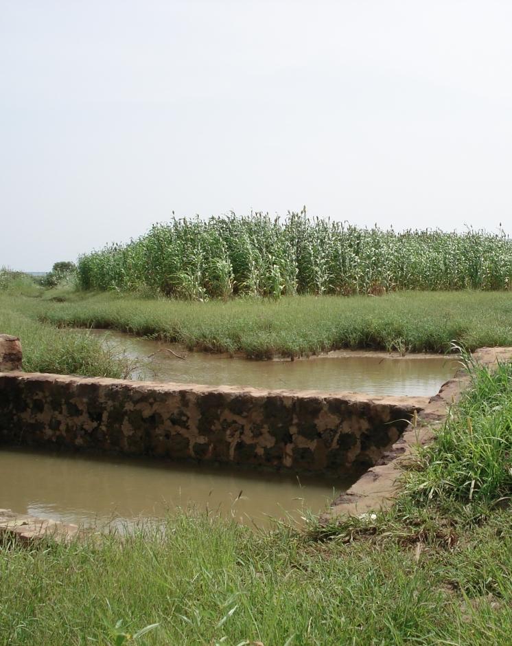
Water-spreading weirs are structures that span the entire width of a valley to spread floodwater over the adjacent land area.
2.2 Descripción detallada de la Tecnología
Descripción:
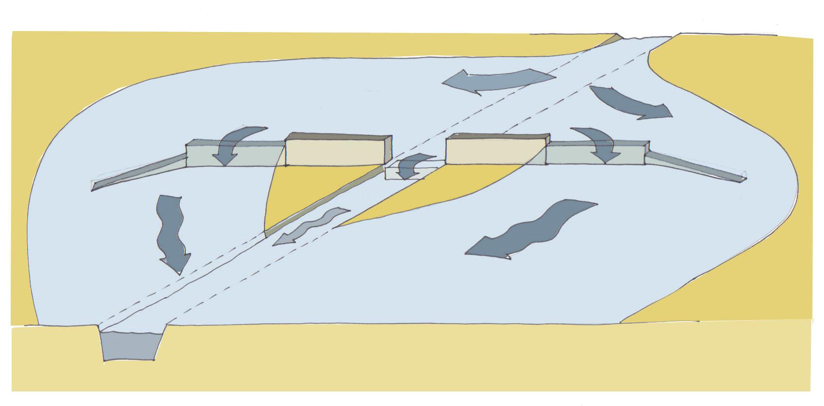
Over the last 12 years water-spreading weirs have been introduced and improved as a new rehabilitation technique for degraded dry valleys in Burkina Faso, Niger and Chad. In Chad 104 water-spreading weirs were constructed in the scope of the two development projects, initiated by the German Technical Cooperation (GIZ) and the Swiss Development Cooperation (SDC) in the 1990s. Water-spreading weirs are made of natural stones and cement, and consist of a spillway in the actual riverbed and lateral abutments and wings. Floodwaters are spread over the adjacent land area above the structure, where they eventually overflow the lateral wings and then slowly flow back towards the riverbed below the structure. As a result the land area below the weir is flooded. The lateral spreading of the water causes the land area above and below the structure to be flooded and supplies it with sediment. Water infiltrates, gullies in the valley are filled and the riverbed is raised. Thanks to the infiltration, the groundwater table also rises in a few years.
Purpose of the Technology: In dry valleys in which water flows in the rivers for only a few days a year, the weirs serve to distribute the incoming runoff over the valley floor and allow as much water as possible to infiltrate the soil. The aquifer is thus replenished and is then available for agricultural use. In contrast to the various types of dams, the goal of water-spreading weirs is not to create reservoirs for later use. What water-spreading weirs do is cause a temporary flooding of the adjacent land area above and below the weir. Depending on user preferences, the primary goal may be 1) agricultural use, 2) sylvo-pastoral use or 3) the replenishment and rising of the water table.
Establishment / maintenance activities and inputs: Water-spreading weirs require detailed technical planning and experienced engineering and construction firms. The bulk of the work is performed using local materials and by village craftsmen and helpers.
Natural / human environment: Compared to small impoundment dams, retention basins and microweirs, water-spreading weirs are especially well-suited for shallow, wide valleys that, due to severe gully erosion, are no longer inundated by small and medium
volume floodwaters. The flooding no longer takes place because the actual riverbed has been deeply eroded and enlarged. However, water-spreading weirs are also suitable for improving agricultural productivity in more or less intact valley floors. Water-spreading weirs are successful in regions where precipitation during the growing season is erratic and where the weirs ensure a more evenly distributed water supply for crops, as well as in zones in which water enrichment makes one or two additional growing seasons possible. At the present time they are in use in a broad area where annual rainfall ranges from 50 to 1,200 mm/year.
2.3 Fotografías de la Tecnología
Galería de medios
2.5 País/ región/ lugares donde la Tecnología fue aplicada y que se hallan comprendidos por esta evaluación
País:
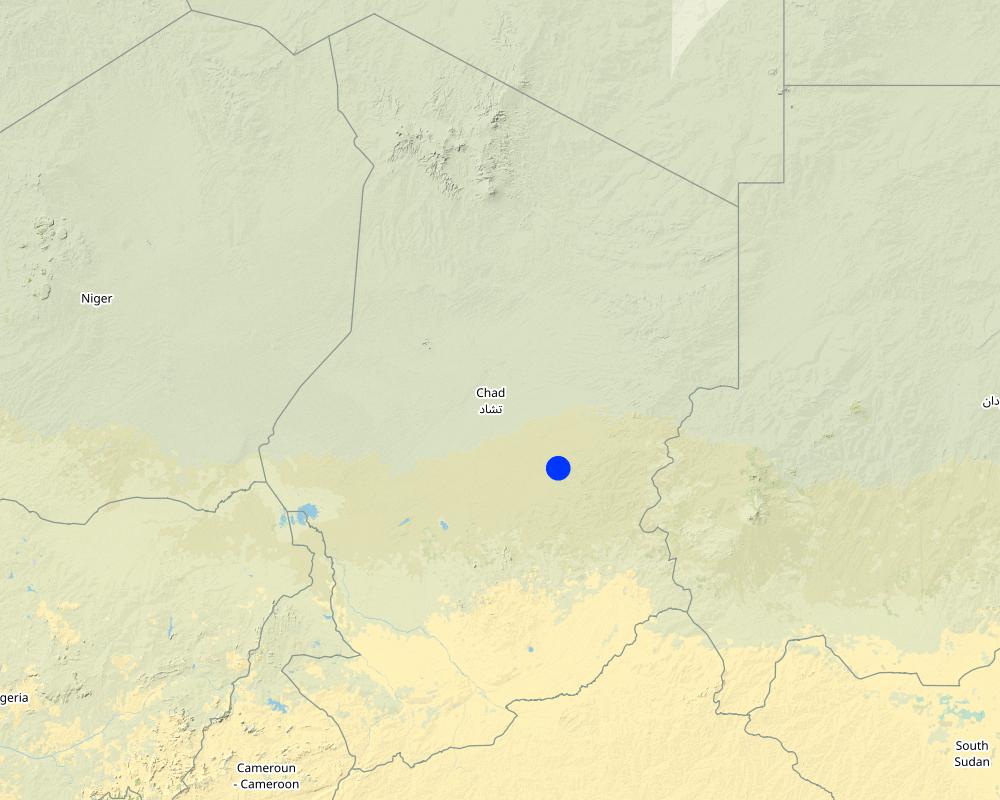
Chad
Región/ Estado/ Provincia:
Eastern Chad
Especifique la difusión de la Tecnología:
- distribuida parejamente sobre un área
Si se desconoce el área precisa, indique el área aproximada cubierta:
- 10-100 km2
Map
×2.6 Fecha de la implementación
Si no se conoce el año preciso, indique la fecha aproximada:
- 10-50 años atrás
2.7 Introducción de la Tecnología
Especifique cómo se introdujo la Tecnología:
- mediante proyectos/ intervenciones externas
Comentarios (tipo de proyecto, etc.):
The first water-spreading weirs were introduced during the 1990s in Chad through Swiss cooperation
3. Clasificación de la Tecnología MST
3.1 Propósito(s) principal(es) de la Tecnología MST
- mejorar la producción
- reducir, prevenir, restaurar la degradación del suelo
3.2 Tipo(s) actuales de uso de la tierra donde se aplica la Tecnología

Tierras cultivadas
- Cosecha anual

Tierra de pastoreo
Pastoreo extenso:
- Pastoralismo semi-nómada
Comentarios:
Major land use problems (compiler’s opinion): Substantial degradation of drainage basins in the Sahel due to population growth and intense land-use pressure has been observed since the 1960s. Climate change has further amplified this trend. The expansion of agriculture and intensification of grazing and logging have caused the natural vegetation cover to decline. This process has been accelerated by severe droughts and has led to the degradation of the soils. Sparse vegetation cover and structurally damaged soils reduce rainfall infiltration into the soil, resulting in more runoff and soil erosion on plateaus and slopes. Runoff is concentrated in the valleys, in which heavy floodwaters
wash away fertile soils and lead to deep erosion of the riverbed. The annual, recurrent small and medium-size floods that normally cause temporary inundation of the valleys and deposition of fertile sediments no longer occur.
3.4 Provisión de agua
otra (ej. post-inundación):
- Post-flooding
Comentarios:
Water supply: Also mixed rainfed - irrigated and rainfed
3.5 Grupo MST al que pertenece la Tecnología
- medida de pendiente transversal
- Manejo de irrigación: (incl. provisión de agua, invernaderos)
- diversión y drenaje de agua
3.6 Medidas MST que componen la Tecnología

medidas estructurales
- S6: Muros, barreras, vallas, cercas
3.7 Principales tipos de degradación del suelo encarados con la Tecnología

erosión de suelos por agua
- Wt: pérdida de capa arable/ erosión de la superficie
- Wg: erosión en cárcavas

degradación del agua
- Hg: cambio en nivel de aguas subterráneas/ nivel de acuífero
Comentarios:
Main type of degradation addressed: Wt: loss of topsoil / surface erosion, Wg: gully erosion / gullying, Hg: change in groundwater / aquifer level
Main causes of degradation: soil management (abandonment of fallow periods), deforestation / removal of natural vegetation (incl. forest fires) (for agricultural expansion), over-exploitation of vegetation for domestic use, droughts, population pressure
Secondary causes of degradation: overgrazing
3.8 Prevención, reducción o restauración de la degradación del suelo
Especifique la meta de la Tecnología con relación a la degradación de la tierra:
- reducir la degradación del suelo
- restaurar/ rehabilitar tierra severamente degradada
Comentarios:
Main goals: rehabilitation / reclamation of denuded land
Secondary goals: mitigation / reduction of land degradation
4. Especificaciones técnicas, actividades de implementación, insumos y costos
4.1 Dibujo técnico de la Tecnología
Autor:
Heinz Bender
4.3 Actividades de establecimiento
| Actividad | Momento (estación) | |
|---|---|---|
| 1. | Excavating the steps | |
| 2. | Excavating the wall foundations | |
| 3. | Pouring the foundations | |
| 4. | Building the walls | |
| 5. | Finishing the walls and filling the stilling basin |
4.4 Costos e insumos necesarios para el establecimiento
| Especifique insumo | Unidad | Cantidad | Costos por unidad | Costos totales por insumo | % de los costos cubiertos por los usuarios de las tierras | |
|---|---|---|---|---|---|---|
| Mano de obra | Labour | ha | 1,0 | 750,0 | 750,0 | 100,0 |
| Equipo | Total costs for equipment | ha | 1,0 | 750,0 | 750,0 | |
| Material de construcción | Stone | ha | 1,0 | 750,0 | 750,0 | |
| Costos totales para establecer la Tecnología | 2250,0 | |||||
4.6 Costos e insumos necesarios para actividades de mantenimiento/ recurrentes (por año)
| Especifique insumo | Unidad | Cantidad | Costos por unidad | Costos totales por insumo | % de los costos cubiertos por los usuarios de las tierras | |
|---|---|---|---|---|---|---|
| Mano de obra | Labour | ha | 1,0 | 50,0 | 50,0 | 100,0 |
| Equipo | Total costs for equipment | ha | 1,0 | 50,0 | 50,0 | |
| Material de construcción | Stone | ha | 1,0 | 50,0 | 50,0 | |
| Indique los costos totales para mantenecer la Tecnología | 150,0 | |||||
Comentarios:
The costs were calculated per structure (one diversion weir). The length of the weir varies depending on the width of the valley it is constructed in. The weir has to span the whole valley which is usually between 100 and 1000 m wide.
5. Entorno natural y humano
5.1 Clima
Lluvia anual
- < 250 mm
- 251-500 mm
- 501-750 mm
- 751-1,000 mm
- 1,001-1,500 mm
- 1,501-2,000 mm
- 2,001-3,000 mm
- 3,001-4,000 mm
- > 4,000 mm
Especificaciones/ comentarios sobre la cantidad de lluvia:
251-500 mm Ranked 1
<250 mm Ranked 2
150-400 mm / year
Zona agroclimática
- semi-árida
Thermal climate class: tropics
5.2 Topografía
Pendientes en promedio:
- plana (0-2 %)
- ligera (3-5%)
- moderada (6-10%)
- ondulada (11-15%)
- accidentada (16-30%)
- empinada (31-60%)
- muy empinada (>60%)
Formaciones telúricas:
- meseta/ planicies
- cordilleras
- laderas montañosas
- laderas de cerro
- pies de monte
- fondo del valle
Zona altitudinal:
- 0-100 m s.n.m.
- 101-500 m s.n.m.
- 501-1,000 m s.n.m
- 1,001-1,500 m s.n.m
- 1,501-2,000 m s.n.m
- 2,001-2,500 m s.n.m
- 2,501-3,000 m s.n.m
- 3,001-4,000 m s.n.m
- > 4,000 m s.n.m
5.3 Suelos
Profundidad promedio del suelo:
- muy superficial (0-20 cm)
- superficial (21-50 cm)
- moderadamente profunda (51-80 cm)
- profunda (81-120 cm)
- muy profunda (>120 cm)
Textura del suelo (capa arable):
- fina/ pesada (arcilla)
Materia orgánica de capa arable:
- elevada (>3%)
- media (1-3%)
Si se halla disponible, adjunte una descripción completa de los suelos o especifique la información disponible, por ej., tipo de suelo, pH/ acidez de suelo, capacidad de intercambio catiónico, nitrógeno, salinidad, etc. :
Soil fertility: High
Soil drainage/infiltration: Medium (ranked 1) and good (ranked 2)
Soil water storage capacity: Medium
5.4 Disponibilidad y calidad de agua
Agua subterránea:
5-50 m
Disponibilidad de aguas superficiales:
pobre/ ninguna
Calidad de agua (sin tratar):
agua potable de buena calidad
Comentarios y especificaciones adicionales sobre calidad y cantidad de agua:
Availability of surface water: excess (during heavy rainfalls in the rainy season) or poor/ none (in the dry season)
5.5 Biodiversidad
Diversidad de especies:
- mediana
5.6 Las características de los usuarios de la tierra que aplican la Tecnología
Orientación del mercado del sistema de producción:
- mixta (subsistencia/ comercial)
Ingresos no agrarios:
- menos del 10% de todos los ingresos
Nivel relativo de riqueza:
- pobre
Individuos o grupos:
- grupos/ comunal
Indique otras características relevantes de los usuarios de las tierras:
Population density: < 10 persons/km2
70% of the land users are poor.
Market orientation: Mixed (rainfed crops are for subsistence, post-rainy season crops and irrigated crops (vegetables) mainly for market)
5.7 Área promedio de la tierra usada por usuarios de tierra que aplican la Tecnología
- < 0.5 ha
- 0.5-1 ha
- 1-2 ha
- 2-5 ha
- 5-15 ha
- 15-50 ha
- 50-100 ha
- 100-500 ha
- 500-1,000 ha
- 1,000-10,000 ha
- > 10,000 ha
5.8 Tenencia de tierra, uso de tierra y derechos de uso de agua
Tenencia de tierra:
- comunitaria/ aldea
Derechos de uso de tierra:
- arrendamiento
Comentarios:
In Chad, only the rainfed fields are in private family ownership and inheritable. Reclaimed irrigated fields and vegetable production fields go back to the community and can be redistributed.
6. Impactos y comentarios para concluir
6.1 Impactos in situ demostrados por la Tecnología
Impactos socioeconómicos
Producción
producción de cultivo
Cantidad antes de MST:
158 kg/ha
Cantidad luego de MST:
653 kg/ha
Comentarios/ especifique:
Increase of millet yield in Chad
producción de forraje
calidad de forraje
producción animal
Cantidad antes de MST:
6,000 cattle head
Cantidad luego de MST:
16,000 cattle heads
Comentarios/ especifique:
The increase in groundwater level has led to a significant increase in the number of cattle heads that can be watered
riesgo de fracaso de producción
diversidad de producto
área de producción
Cantidad antes de MST:
2.85 ha
Cantidad luego de MST:
5.29 ha
Comentarios/ especifique:
The numbers are from a study on water-spreading weirs in Niger, but for Chad the situation is comparable
Ingreso y costos
ingreso agrario
Comentarios/ especifique:
Users of water-spreading weirs had 112% higher incomes compared to farmers outside the impact zone from sales of vegetables and surplus grain
carga de trabajo
Comentarios/ especifique:
The workload of women is eased thanks to the availability of and easier access to water due to the shallower water table
Otros impactos socioeconómicos
Income for the community
Comentarios/ especifique:
Temporary income was generated for the local workers during the weir construction. About 231 Euros per user family.
Impactos socioculturales
seguridad alimentaria/ autosuficiencia
Comentarios/ especifique:
Food security assured through crop and livestock farming
situación de salud
Comentarios/ especifique:
Children have a healthier, more diverse diet due to the vegetable production and the introduction of new crops
instituciones comunitarias
Comentarios/ especifique:
The weirs are becoming an element of interaction and social integration for the inhabitants of surrounding villages
MST/ conocimiento de la degradación del suelo
Comentarios/ especifique:
Through training
mitigación de conflicto
Comentarios/ especifique:
Decline in conflicts between farmers and livestock raisers over water rights owing to the fact that sufficient water is now available
situación de grupos en desventaja social y económica
Comentarios/ especifique:
Temporary emigration to Sudan and Lybia has declined and in some villages people who had long since emigrated returned home
Diversification and creation of activities
Comentarios/ especifique:
In the vicinity of the weirs activities such as trading of agricultural products, fishing, watering livestock and making clay tiles have emerged
Training for weir construction
Comentarios/ especifique:
Numerous local masons were trained
Improved planning skills
Comentarios/ especifique:
Village people, service providers, communal representatives, government technical sectors have improved their skills in organisation, planning and implementation
Poverty
Poverty
Impactos ecológicos
Ciclo de agua/ escurrimiento de sedimento
cantidad de agua
cosecha/ recolección de agua
Comentarios/ especifique:
More and longer-lasting bodies of surface water
escurrimiento superficial
nivel freático/ acuífero
Comentarios/ especifique:
In some communities groundwater has risen to a depth of 6m below surface
Suelo
humedad del suelo
pérdida de suelo
Comentarios/ especifique:
Gullies are filled in
ciclo/ recarga de nutrientes
Comentarios/ especifique:
Deposition of nutrients
materia orgánica debajo del suelo C
Comentarios/ especifique:
Deposition of organic matter
Biodiversidad: vegetación, animales
biomasa/ sobre suelo C
Comentarios/ especifique:
Spread of natural vegetation around the rehabilitated valley plains
diversidad vegetal
Comentarios/ especifique:
Vanished plant species return
diversidad animal
Comentarios/ especifique:
Vanished animal species return
diversidad de hábitats
6.2 Impactos fuera del sitio demostrados por la Tecnología
disponibilidad de agua
inundaciones río abajo
colmatación río abajo
capacidad de amortiguación/ filtrado
6.3 Exposición y sensibilidad de la Tecnología al cambio climático gradual y a extremos relacionados al clima/ desastres (desde la percepción de los usuarios de tierras)
Cambio climático gradual
Cambio climático gradual
| Estación | Incremento o reducción | ¿Cómo es que la tecnología soporta esto? | |
|---|---|---|---|
| temperatura anual | incrementó | bien |
Extremos (desastres) relacionados al clima
Desastres climatológicos:
| ¿Cómo es que la tecnología soporta esto? | |
|---|---|
| tormenta de lluvia local | bien |
| tormenta de viento | bien |
Desastres hidrológicos
| ¿Cómo es que la tecnología soporta esto? | |
|---|---|
| inundación general (río) | bien |
6.4 Análisis costo-beneficio
¿Cómo se comparan los beneficios con los costos de establecimiento (desde la perspectiva de los usuarios de tierra)?
Ingresos a corto plazo:
negativo
Ingresos a largo plazo:
muy positivo
¿Cómo se comparan los beneficios con los costos de mantenimiento/ recurrentes (desde la perspectiva de los usuarios de tierra)?
Ingresos a corto plazo:
ligeramente positivo
Ingresos a largo plazo:
muy positivo
Comentarios:
Depending upon the users' experience and the availability of labour, it may take anywhere from 2 to 10 years before the rehabilitated land area reaches its optimum use potential.
6.5 Adopción de la Tecnología
De todos quienes adoptaron la Tecnología, ¿cuántos lo hicieron espontáneamente, por ej. sin recibir nada de incentivos/ materiales:
- 0-10%
Comentarios:
100% of land user families have adopted the Technology with external material support
6000 land user families have adopted the Technology with external material support
Comments on acceptance with external material support: Between 4000 and 8000 households are direct beneficiaries of the construction of water-spreading weirs in Eastern Chad.
There is no trend towards spontaneous adoption of the Technology
Comments on adoption trend: It is unlikely that communities will be able to adopt this technology without external funding. Even for maintenance activities it remains to be seen if the communities will be capable of funding more extensive maintenance work with their low budgets.
6.7 Fuerzas/ ventajas/ oportunidades de la Tecnología
| Fuerzas/ ventajas/ oportunidades desde la perspectiva del compilador o de otra persona de referencia clave |
|---|
|
Through the construction of water-spreading weirs, soils are regularly flooded and supplied with water and sediment. Thus, the arable land area and the yields of the rainy season crops serving as staple food increase. How can they be sustained / enhanced? Ensure proper maintenance of the system. |
| The more frequent flooding of the soils results in increased infiltration, and the groundwater level rises substantially. |
|
Prior to rehabilitation, in most of the sites, it was only possible to grow a rainfed crop and perhaps an irrigated crop on some small areas of land. After, in addition to the rainfed crop grown on larger areas of land, it became possible to grow a post-rainy season crop (culture de contresaison) and, once the water table had risen, an irrigated crop (culture de décrue) as well. How can they be sustained / enhanced? Upscale water-spreading weirs to increase the number of people benefitting. |
|
Post-rainy season crops and irrigated crops diversify agricultural production. They are used as a means of earning cash income. How can they be sustained / enhanced? Improve access to markets. |
| With their capacity to regulate annual floodwaters and harness them to stabilise production, water-spreading weirs are an effective measure for adapting to climate change in regions experiencing increasing variability in rainfall. |
6.8 Debilidades/ desventajas/ riesgos de la Tecnología y formas de sobreponerse a ellos
| Debilidades/ desventajas/ riesgos desde la perspectiva del compilador o de otra persona de referencia clave | ¿Cómo sobreponerse a ellas? |
|---|---|
| It can be assumed that one third of the weirs will require complete renovation every 20 years | The renovation of these weirs can be done for approximately 10% of the initial construction costs |
| Maintenance of the weirs by the management committees is still a weak area. Funds expected from user fees for the plots are often inadequately collected and too low to cover costs. Some management committees lose their drive and neglect their duties. | New fundings sources have to be found and tapped. |
| In spite of the great potential for the use of water-spreading weirs and the very promising results, implementation will continue to depend in the medium term on outside funding, as it is unlikely that the communal budgets will be able to fund investments of this size. | The existing knowledge hast to be spread. |
| Know-how and experience for the construction of water-spreading weirs are still concentrated among a few countries. |
7. Referencias y vínculos
7.1 Métodos/ fuentes de información
7.2 Vínculos a las publicaciones disponibles
Título, autor, año, ISBN:
Deutsche Gesellschaft für Internationale Zusammenarbeit (GIZ) (2011). Water-spreading weirs for the development of degraded dry river valleys. Experience from the Sahel. Frankfurt and Eschborn, GIZ and KFW.
¿Dónde se halla disponible? ¿Costo?
http://www.gtz.de/de/dokumente/giz2012-en-water-spreading-weirs-sahel.pdf
Título, autor, año, ISBN:
Direction du développement et de la coopération DDC (2012). Gestion des eaux de ruissellement dans le Tchad sahélien. Bern, DDC.
¿Dónde se halla disponible? ¿Costo?
http://www.gopa.de/uploads/tx_bdojobopps/PRODOC_Tchad.pdf
Vínculos y módulos
Expandir todo Colapsar todosVínculos
No hay vínculos
Módulos
No se hallaron módulos