Nardi/Vallerani trenches [Níger]
- Creación:
- Actualización:
- Compilador: Dieter Nill
- Editor: –
- Revisores: Deborah Niggli, Alexandra Gavilano
Tranchées Nardi (French)
technologies_1613 - Níger
Visualizar secciones
Expandir todo Colapsar todos1. Información general
1.2 Detalles de contacto de las personas de referencia e instituciones involucradas en la evaluación y la documentación de la Tecnología
Nombre del proyecto que financió la documentación/ evaluación de la Tecnología (si fuera relevante)
Good Practices in Soil and Water Conservation - A contribution to adaptation and farmers ́ resilience towards climate change in the Sahel (GIZ)Nombre de la(s) institución(es) que facilitaron la documentación/ evaluación de la Tecnología (si fuera relevante)
Deutsche Gesellschaft für Internationale Zusammenarbeit (GIZ) - Alemania1.3 Condiciones referidas al uso de datos documentados mediante WOCAT
El compilador y la/s persona(s) de referencia claves aceptan las condiciones acerca del uso de los datos documentados mediante WOCAT:
Sí
1.4 Declaración de la sostenibilidad de la Tecnología descrita
¿La Tecnología aquí descrita resulta problemática en relación a la degradación de la tierra, de tal forma que no puede considerársela una tecnología sostenible para el manejo de la tierra?
No
2. Descripción de la Tecnología MST
2.1 Breve descripción de la Tecnología
Definición de la Tecnología:
Nardi/Vallerani trenches are microcatchments which are made using a special tractor-pulled plough to restore degraded and encrusted forests and rangelands
2.2 Descripción detallada de la Tecnología
Descripción:
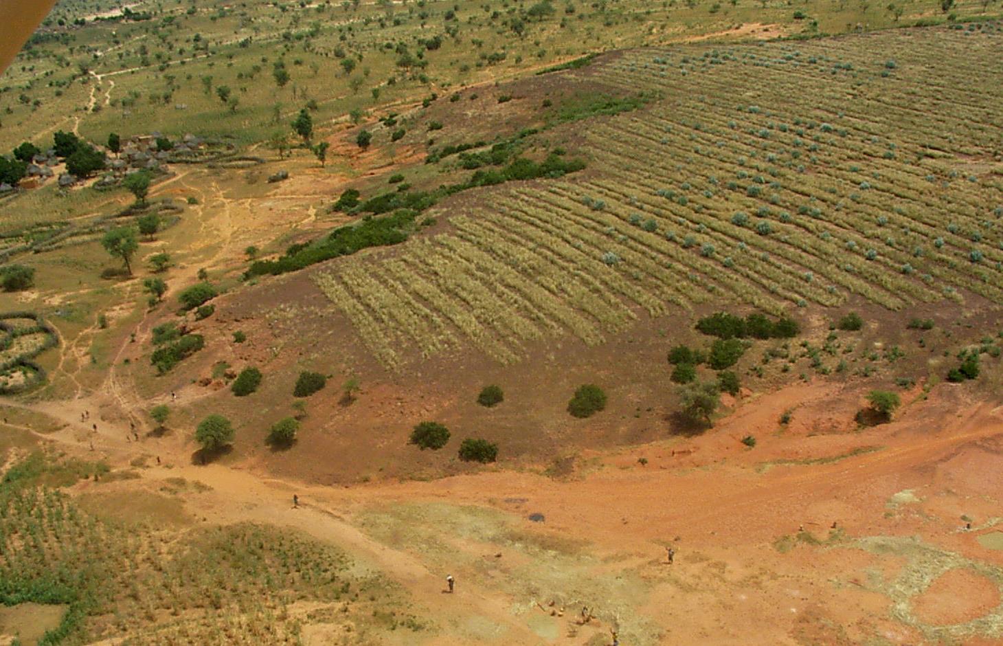
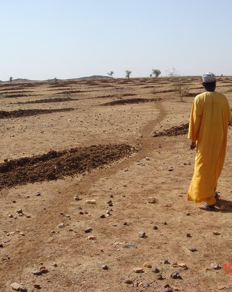
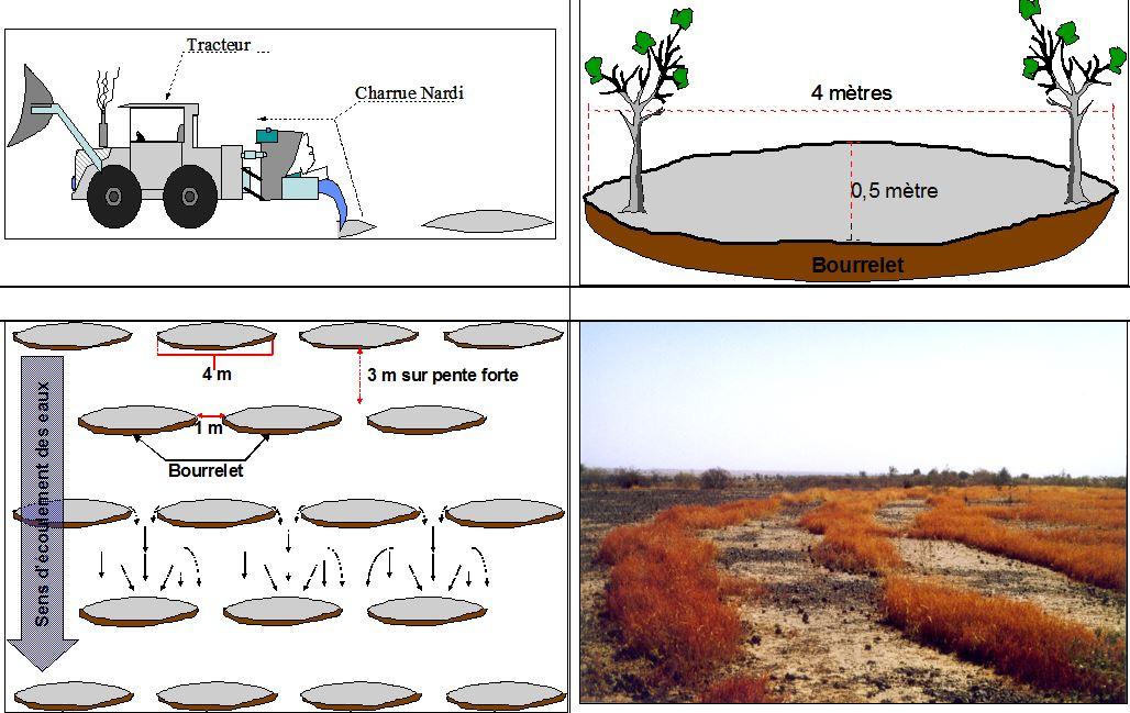
Nardi/Vallerani trenches are microcatchments 4 m long and 0.5 m wide. They are made using a tractor-pulled plough specifically designed for this purpose. The Nardi plough cuts a furrow perpendicular to the slope, throwing up a ridge on the downhill side and thereby creating a barrier on that side of the furrow. The number of trenches varies according to the gradient of the terrain and the type of soil: the recommended number of microcatchments for flat or gently sloping terrain is between 250 and 400 per hectare, with the rows spaced 5 to 7 m apart; and for steeper slopes, the rows should be spaced 3 to 4 m apart, with a density of up to 600 microcatchments per hectare. In each Nardi/Vallerani microcatchment, two or three trees are planted or sown by direct seeding and then separated when they come up. Perennial grasses are sown a year later to allow the trees to become established first. The choice of species largely depends on the use to which the improved land is to be put and the priorities of the beneficiaries. It is recommended that the improved site be protected from grazing animals for at least three years to give the trees time to grow and the grass time to reproduce naturally, although the exact amount of time required will depend on the type of trees planted and how degraded the site is.
Nardi/Vallerani trenches are generally combined with scarification, which is carried out using a tractor-pulled scarifier. The strips between the trenches are scarified a year after they have been dug. These scarified strips are sown with perennial grasses at the same time as the trenches. The trees planted the year before are a year old, and the risk of the saplings being choked by the grass is minimal.
Runoff collects in the Vallerani microcatchments, improving the infiltration of water into the soil and the retention of water for the plants growing in them. They also serve to loosen the soil and improve the plants’ access to nutrients. Windborne seeds are trapped in the microcatchments, which helps to build up the natural grass cover.
This technique is particularly effective when rainfall is low, as the microcatchments retain water and make it available to the plants growing in them.
In the medium term, this technique is effective in protecting the land against water and wind erosion and rehabilitating barren land with no vegetation. In wet years, the microcatchments protect the land downhill from excessive run- off by retaining part of the water.
Implemented on a wide scale, this technique can extend and improve the quality of forest and rangeland and reduce the problems for livestock keepers in years when the quality of pasture is not good. In the medium and long- term, the technique can increase the supply of firewood, timber and other wood products. Even in the short term, it increases the production of straw, which can be used as forage, for making roofing and mats or sold to generate extra income.
Establishment / maintenance activities and inputs: In order to ensure the sustainability of the investment, it is necessary to take the following steps before constructing the trenches: ensure that the communities are motivated to invest in the measure; ensure that the communities have the capacity to do the work and the technical expertise required to implement the measures and develop and manage the sites; ensure that there are sufficiently strong local and regional markets for forest/rangeland products; clearly define the objective (intended uses after improvement); clarify ownership of the land to be improved; jointly define who the beneficiaries will be; formulate an agreement establishing rules governing the protection, use and upkeep of the site.
The right grass species must be chosen to ensure the successful establishment of vegetation cover, taking the following factors into consideration: needs of livestock keepers and/or agro-pastoralists; species suited to environmental conditions, taking into account climate changes; palatability and nutritive value of the species and any secondary uses they may have; availability of seeds; potential for marketing products.
The Sahel is a region where the population has always faced a high degree of climate variability, manifested both in terms of time (unexpected dry spells can occur during the rainy season) and in terms of space (rainfall can vary greatly from one area to another). The population is mainly composed of small farmers and livestock keepers.
Over the last two decades, the effects of climate change have exacerbated the already difficult conditions. Accord¬ing to projections made by climatologists, the Sahel will experience a rise in temperatures combined with highly variable rainfall and an increase in extreme weather events.
The Soil and Water conservation and rehabilitation techniques have helped people in the Sahel to manage their ecosystems more effectively and improve their productive land. As a result, communities are better prepared to cope with environmental changes (changes in the climate, land degradation, etc.) and the im¬pact of shocks, particularly droughts
2.3 Fotografías de la Tecnología
Galería de medios
2.5 País/ región/ lugares donde la Tecnología fue aplicada y que se hallan comprendidos por esta evaluación
País:
Níger
Región/ Estado/ Provincia:
Niger
Especifique más el lugar :
Regions of Tillabéri, Filingué, Ouallam, Téra and Tahuoa
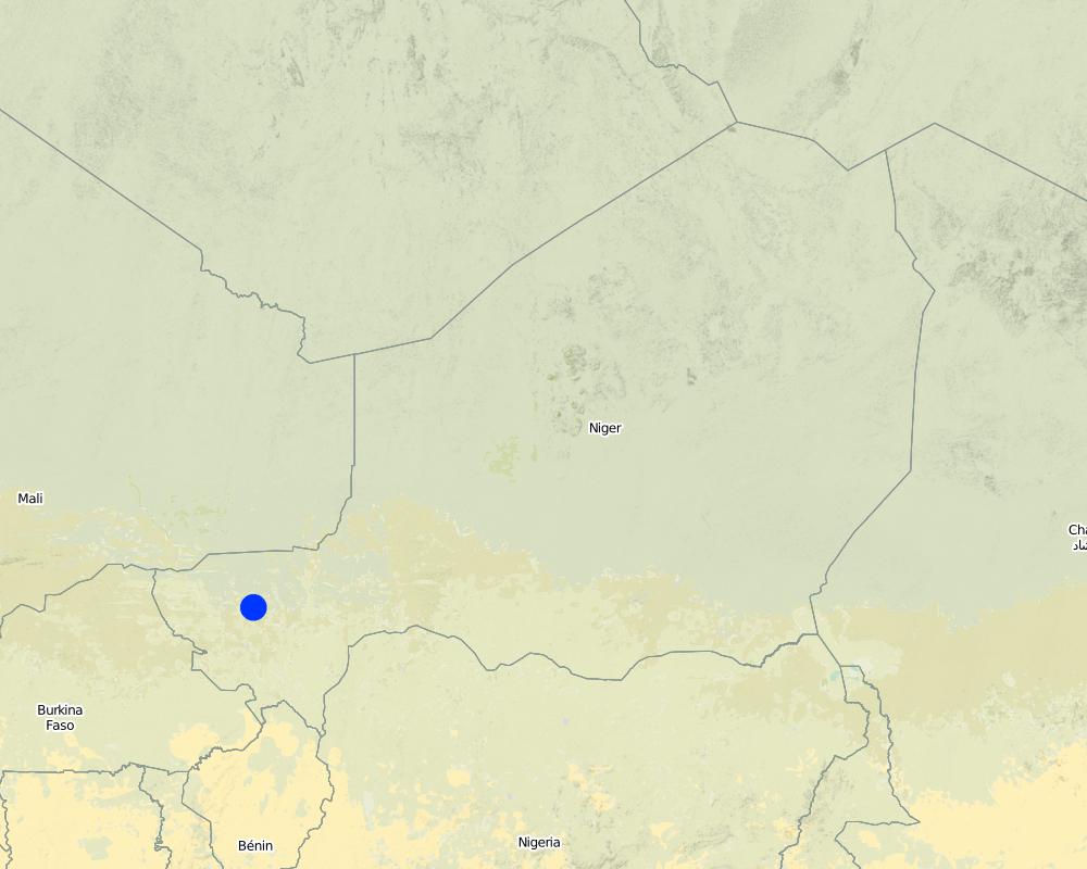
Map
×2.6 Fecha de la implementación
Si no se conoce el año preciso, indique la fecha aproximada:
- 10-50 años atrás
2.7 Introducción de la Tecnología
Especifique cómo se introdujo la Tecnología:
- mediante proyectos/ intervenciones externas
Comentarios (tipo de proyecto, etc.):
developed, implemented and disseminated as part of projects and programmes undertaken from the 1980s onwards to combat desertification and improve natural resource management. Implemented by GIZ (German Federal Enterprise for International Cooperation), PDRT (Projet de développement rural de Tahoua - Tahoua Rural Development Project), PASP (Projet de protection intégrée des ressources agro-sylvo-pastorales Tillabéri-Nord - Project for the Integrated Protection of Agricultural, Forest and Rangeland Resources in Tillabéri-Nord)
3. Clasificación de la Tecnología MST
3.1 Propósito(s) principal(es) de la Tecnología MST
- reducir, prevenir, restaurar la degradación del suelo
3.2 Tipo(s) actuales de uso de la tierra donde se aplica la Tecnología

Tierra de pastoreo
Pastoreo extenso:
- Pastoralismo semi-nómada
Pastoreo intensivo/ producción de forraje:
- Cortar y llevar/ cero pastoreo

Bosques
- Bosques/ zonas boscosas (semi) naturales
Bosques/ zonas boscosas (semi-) naturales: Especifique tipo de manejo:
- Tala selectiva
Productos y servicios:
- Madera
- Leña
- Frutos y nueces
- Otros productos forestales
- Pastoreo/ ramoneo
Comentarios:
Major land use problems (compiler’s opinion): crusting, surface runoff, water and wind erosion, unadapted land use methods, rapidly growing population increasing pressure on land, reduced or abandoned fallow periods, insecure access to land.
Farmers are mainly agropastoralists with some communities specialised on pure pastoralism
Constraints of forested government-owned land or commons
Number of growing seasons per year: 1
Longest growing period in days: 120, Longest growing period from month to month: August to October
Livestock density: 1-10 LU /km2
3.4 Provisión de agua
Provisión de agua para la tierra donde se aplica la Tecnología:
- mixta de secano – irrigada
3.5 Grupo MST al que pertenece la Tecnología
- cobertura de suelo/ vegetal mejorada
- perturbación mínima del suelo
- medida de pendiente transversal
3.6 Medidas MST que componen la Tecnología

medidas vegetativas
- V1: Cubierta de árboles y arbustos
- V2: Pastos y plantas herbáceas perennes

medidas estructurales
- S4: Acequias niveladas, fosas
3.7 Principales tipos de degradación del suelo encarados con la Tecnología

erosión de suelos por agua
- Wt: pérdida de capa arable/ erosión de la superficie
- Wo: efectos de degradación fuera del sitio

erosión de suelos por viento
- Et: pérdida de capa arable

deterioro químico del suelo
- Cn: reducción de la fertilidad y contenido reducido de la materia orgánica del suelo (no ocasionados por la erosión)

deterioro físico del suelo
- Pc: compactación
- Pk: desmoronamiento y encostramiento

degradación biológica
- Bc: reducción de la cobertura vegetal del suelo

degradación del agua
- Ha: aridificación
Comentarios:
Main causes of degradation: soil management (Unadapted land use methods, reduced or abandoned fallow periods), crop management (annual, perennial, tree/shrub) (Neglect of fallow periods and crop rotation), droughts (due to heat waves), population pressure (rapidly growing population increasing pressure on land), land tenure (insecure access to land and collectively managaed commons), poverty / wealth (very poor population)
Secondary causes of degradation: deforestation / removal of natural vegetation (incl. forest fires) (deforestation through overgrazing and fire wood collection), over-exploitation of vegetation for domestic use (firewood collection), overgrazing (cattle, shee and goats), change in temperature (Climate change: heat waves), change of seasonal rainfall (more variable onset of rain), Heavy / extreme rainfall (intensity/amounts) (more variable and intensive rains), wind storms / dust storms (frequent storms), floods (due to intensive rains), labour availability (some migration of men to nearby cities), education, access to knowledge and support services (high level of illiteracy)
3.8 Prevención, reducción o restauración de la degradación del suelo
Especifique la meta de la Tecnología con relación a la degradación de la tierra:
- reducir la degradación del suelo
- restaurar/ rehabilitar tierra severamente degradada
4. Especificaciones técnicas, actividades de implementación, insumos y costos
4.1 Dibujo técnico de la Tecnología
Especificaciones técnicas (relacionadas al dibujo técnico):
Nardi/Vallerani trenches are microcatchments 4 m long and 0.5 m wide. The Nardi plough cuts a furrow perpendicular to the slope, throwing up a ridge on the downhill side and thereby creating a barrier on that side of the furrow. The recommended number of microcatchments for flat or gently sloping terrain is between 250 and 400 per hectare, with the rows spaced 5 to 7 m apart; and for steeper slopes, the rows should be spaced 3 to 4 m apart, with a density of up to 600 microcatchments per hectare.
Source of drawing: Ministère du Développement Agricole Niger (without date): Recueil des fiches techniques en gestion des ressources naturelles et de productions agro-sylvo-pastorales.
Location: Niger
Technical knowledge required for field staff / advisors: high
Technical knowledge required for land users: moderate
Main technical functions: control of dispersed runoff: retain / trap, control of dispersed runoff: impede / retard, control of concentrated runoff: retain / trap, control of concentrated runoff: impede / retard, improvement of ground cover, improvement of surface structure (crusting, sealing), improvement of topsoil structure (compaction), increase of infiltration, increase / maintain water stored in soil, water harvesting / increase water supply
Secondary technical functions: stabilisation of soil (eg by tree roots against land slides), increase in nutrient availability (supply, recycling,…), sediment retention / trapping, sediment harvesting, reduction in wind speed, promotion of vegetation species and varieties (quality, eg palatable fodder)
Vegetative measure: within each microcatchment 2-3 trees
Vegetative material: T : trees / shrubs, G : grass
Number of plants per (ha): 700-1250
Vegetative measure: Vegetative material: T : trees / shrubs, G : grass
Retention/infiltration ditch/pit, sediment/sand trap
Spacing between structures (m): 5-7
Depth of ditches/pits/dams (m): 0.4
Width of ditches/pits/dams (m): 0.5
Length of ditches/pits/dams (m): 4
Vegetation is used for stabilisation of structures.
4.2 Información general sobre el cálculo de insumos y costos
otra / moneda nacional (especifique):
CFA Franc
Si fuera relevante, indique la tasa de cambio de dólares americanos a la moneda local (ej. 1 U$ = 79.9 Reales Brasileros): 1 U$ =:
521,18
4.3 Actividades de establecimiento
| Actividad | Momento (estación) | |
|---|---|---|
| 1. | The Nardi plough cuts a furrow perpendicular to the slope, throwing up a ridge on the downhill side and thereby creating a barrier on that side of the furrow | |
| 2. | In each Nardi/Vallerani microcatchment, two or three trees are planted or sown by direct seeding |
4.4 Costos e insumos necesarios para el establecimiento
| Especifique insumo | Unidad | Cantidad | Costos por unidad | Costos totales por insumo | % de los costos cubiertos por los usuarios de las tierras | |
|---|---|---|---|---|---|---|
| Mano de obra | labour | ha | 1,0 | 16,3 | 16,3 | 100,0 |
| Equipo | machine use | ha | 1,0 | 23,6 | 23,6 | 100,0 |
| Equipo | transport and planting trees | ha | 1,0 | 12,3 | 12,3 | 100,0 |
| Material para plantas | seedlings | ha | 1,0 | 52,0 | 52,0 | 100,0 |
| Costos totales para establecer la Tecnología | 104,2 | |||||
| Costos totales para establecer la Tecnología en USD | 0,2 | |||||
4.5 Actividades de establecimiento/ recurrentes
| Actividad | Momento/ frequencia | |
|---|---|---|
| 1. | Separating trees when they come up | |
| 2. | Perennial grasses are sown a year after the trees to allow the trees to become established first. | |
| 3. | The strips between the trenches are scarifieda year after they have been dug. These scarified strips are sown with perennial grasses at the same time as the trenches. |
4.6 Costos e insumos necesarios para actividades de mantenimiento/ recurrentes (por año)
Comentarios:
Microcatchments on low-gradient terrain
• 1 Nardi plough (imported from Italy)
• tractor hire.
Labour
• 8.5 man-days per ha.
Other costs
• 800 seedlings and 15 kg of seeds (plus transport and replacement plants).
4.7 Factores más determinantes que afectan los costos:
Describa los factores más determinantes que afectan los costos:
The slope determines the costs. The number of trenches varies according to the gradient of the terrain and the type of soil: the recommended number of microcatchments for flat or gently sloping terrain is between 250 and 400 per hectare, with the rows spaced 5 to 7 m apart; and for steeper slopes, the rows should be spaced 3 to 4 m apart, with a density of up to 600 microcatchments per hectare.
5. Entorno natural y humano
5.1 Clima
Lluvia anual
- < 250 mm
- 251-500 mm
- 501-750 mm
- 751-1,000 mm
- 1,001-1,500 mm
- 1,501-2,000 mm
- 2,001-3,000 mm
- 3,001-4,000 mm
- > 4,000 mm
Zona agroclimática
- semi-árida
Thermal climate class: subtropics
5.2 Topografía
Pendientes en promedio:
- plana (0-2 %)
- ligera (3-5%)
- moderada (6-10%)
- ondulada (11-15%)
- accidentada (16-30%)
- empinada (31-60%)
- muy empinada (>60%)
Formaciones telúricas:
- meseta/ planicies
- cordilleras
- laderas montañosas
- laderas de cerro
- pies de monte
- fondo del valle
Zona altitudinal:
- 0-100 m s.n.m.
- 101-500 m s.n.m.
- 501-1,000 m s.n.m
- 1,001-1,500 m s.n.m
- 1,501-2,000 m s.n.m
- 2,001-2,500 m s.n.m
- 2,501-3,000 m s.n.m
- 3,001-4,000 m s.n.m
- > 4,000 m s.n.m
5.3 Suelos
Profundidad promedio del suelo:
- muy superficial (0-20 cm)
- superficial (21-50 cm)
- moderadamente profunda (51-80 cm)
- profunda (81-120 cm)
- muy profunda (>120 cm)
Textura del suelo (capa arable):
- mediana (limosa)
- fina/ pesada (arcilla)
Materia orgánica de capa arable:
- media (1-3%)
5.4 Disponibilidad y calidad de agua
Agua subterránea:
5-50 m
Disponibilidad de aguas superficiales:
mediana
Calidad de agua (sin tratar):
solo para uso agrícola (irrigación)
5.5 Biodiversidad
Diversidad de especies:
- baja
5.6 Las características de los usuarios de la tierra que aplican la Tecnología
Orientación del mercado del sistema de producción:
- subsistencia (autoprovisionamiento)
- mixta (subsistencia/ comercial)
Ingresos no agrarios:
- 10-50% de todo el ingreso
Nivel relativo de riqueza:
- muy pobre
- pobre
Nivel de mecanización:
- trabajo manual
- tracción animal
Género:
- hombres
Indique otras características relevantes de los usuarios de las tierras:
Population density: 10-50 persons/km2
Annual population growth: 3% - 4% (mostly poor households below poverty line).
Off-farm income specification: men migrate temporarily or permanently to cities for off-farm income, women and men seasonally carry out paid farm work
5.7 Área promedio de la tierra usada por usuarios de tierra que aplican la Tecnología
- < 0.5 ha
- 0.5-1 ha
- 1-2 ha
- 2-5 ha
- 5-15 ha
- 15-50 ha
- 50-100 ha
- 100-500 ha
- 500-1,000 ha
- 1,000-10,000 ha
- > 10,000 ha
¿Esto se considera de pequeña, mediana o gran escala (refiriéndose al contexto local)?
- pequeña escala
5.8 Tenencia de tierra, uso de tierra y derechos de uso de agua
Tenencia de tierra:
- estado
- comunitaria/ aldea
Derechos de uso de tierra:
- acceso abierto (no organizado)
- comunitarios (organizado)
Derechos de uso de agua:
- acceso abierto (no organizado)
- comunitarios (organizado)
Comentarios:
traditional land use rights prevail. On fields individual land use rights, communal land on pasture and forest land (collection of wood and other products (fruits, medicinal plants))
5.9 Acceso a servicios e infraestructura
salud:
- pobre
- moderado
- bueno
educación:
- pobre
- moderado
- bueno
asistencia técnica:
- pobre
- moderado
- bueno
empleo (ej. fuera de la granja):
- pobre
- moderado
- bueno
mercados:
- pobre
- moderado
- bueno
energía:
- pobre
- moderado
- bueno
caminos y transporte:
- pobre
- moderado
- bueno
agua potable y saneamiento:
- pobre
- moderado
- bueno
servicios financieros:
- pobre
- moderado
- bueno
6. Impactos y comentarios para concluir
6.1 Impactos in situ demostrados por la Tecnología
Impactos socioeconómicos
Producción
producción de forraje
calidad de forraje
producción animal
Comentarios/ especifique:
It is recommended that the improved site be protected from grazing animals for at least three years to give the trees time to grow and the grass time to reproduce naturally
producción de madera
área de producción
Ingreso y costos
ingreso agrario
Otros impactos socioeconómicos
amount of straw (used as forage or sold and/or used for roofing, doors and fencing)
Impactos socioculturales
seguridad alimentaria/ autosuficiencia
mitigación de conflicto
contribution to human well-being
Comentarios/ especifique:
Implemented on a wide scale, this technique can extend and improve the quality of forest and rangeland and reduce the problems for livestock keepers in years when the quality of pasture is not good. In the medium and long-term, the technique can increase the supply of firewood, timber and other wood products. Even in the short term, this technique increases the production of straw, which can be used as forage, for making roofing and mats or sold to generate extra income. The forest/rangeland sites help communities to bridge the hunger gap, and in lean years, the women collect forest products, such as leaves, pods and fruit to supplement their diet. Sometimes, small quantities of wood are sold to buy cereals. Ingredients for medicinal products and other secondary products, such as gum arabic, are collected from the trees and bushes.
Impactos ecológicos
Ciclo de agua/ escurrimiento de sedimento
cosecha/ recolección de agua
escurrimiento superficial
Suelo
humedad del suelo
cubierta del suelo
pérdida de suelo
encostramiento/ sellado de suelo
compactación de suelo
ciclo/ recarga de nutrientes
Biodiversidad: vegetación, animales
biomasa/ sobre suelo C
Cantidad antes de MST:
100 kg/ha
Cantidad luego de MST:
540 kg/ha
diversidad vegetal
Reducción de riesgos de desastres y riesgos climáticos
velocidad de viento
6.2 Impactos fuera del sitio demostrados por la Tecnología
inundaciones río abajo
sedimentos transportados por el viento
6.3 Exposición y sensibilidad de la Tecnología al cambio climático gradual y a extremos relacionados al clima/ desastres (desde la percepción de los usuarios de tierras)
Cambio climático gradual
Cambio climático gradual
| Estación | Incremento o reducción | ¿Cómo es que la tecnología soporta esto? | |
|---|---|---|---|
| temperatura anual | incrementó | bien |
Extremos (desastres) relacionados al clima
Desastres climatológicos:
| ¿Cómo es que la tecnología soporta esto? | |
|---|---|
| tormenta de lluvia local | no muy bien |
| tormenta de viento | bien |
Desastres climatológicos
| ¿Cómo es que la tecnología soporta esto? | |
|---|---|
| sequía | bien |
Desastres hidrológicos
| ¿Cómo es que la tecnología soporta esto? | |
|---|---|
| inundación general (río) | no muy bien |
Comentarios:
Physical structures can be biologically stabilized through planting of grass, bushes or trees. Damages are generally small but need to be repaired quickly.
6.4 Análisis costo-beneficio
¿Cómo se comparan los beneficios con los costos de establecimiento (desde la perspectiva de los usuarios de tierra)?
Ingresos a corto plazo:
positivo
Ingresos a largo plazo:
muy positivo
¿Cómo se comparan los beneficios con los costos de mantenimiento/ recurrentes (desde la perspectiva de los usuarios de tierra)?
Ingresos a corto plazo:
positivo
Ingresos a largo plazo:
muy positivo
Comentarios:
In the short term, this technique increases the production of straw, which can be used as forage, for making roofing and mats or sold to generate extra income. In the medium and long-term, the technique can increase the supply of firewood, timber and other wood products.
6.5 Adopción de la Tecnología
Comentarios:
The techniques were implemented with food for work in the 1990s to 2000. At the end, the work provided by land users was not compensated. Only small equipment and transportation were provided for free. Some adoption (without support by the project) has been observed in some places.
There is a little trend towards spontaneous adoption of the Technology. Some adoption (without support by the project) has been observed in some places.
6.7 Fuerzas/ ventajas/ oportunidades de la Tecnología
| Fuerzas/ ventajas/ oportunidades desde la perspectiva del compilador o de otra persona de referencia clave |
|---|
| In the medium term, this technique is effective in protecting the land against water and wind erosion and rehabilitating barren land with no vegetation. |
| Runoff collects in the Vallerani microcatchments, improving the infiltration of water into the soil and the retention of water for the plants growing in them. They also serve to loosen the soil and improve the plants’ access to nutrients. Windborne seeds are trapped in the microcatchments, which helps to build up the natural grass cover. |
| In wet years, the micro-catchments protect the land downhill from excessive runoff by retaining part of the water. |
| This technique is particularly effective when rainfall is low, as the microcatchments retain water and make it available to the plants growing within them. |
| The average additional output of dry matter in the form of herbaceous biomass was approximately 540 kg/ha, compared with less than 100 kg per hectare on land where the technique was not applied |
6.8 Debilidades/ desventajas/ riesgos de la Tecnología y formas de sobreponerse a ellos
| Debilidades/ desventajas/ riesgos desde la perspectiva del compilador o de otra persona de referencia clave | ¿Cómo sobreponerse a ellas? |
|---|---|
| Animal production is reduced because the improved site should be protected from grazing animals for at least three years to give the trees time to grow and the grass time to reproduce naturally | |
| Vallerani microcatchments are recommended for use on well-structured soils (soils with high clay content and lateritic and stony soils). On poorly structured soils (sandy, silty soils), the furrows tend to close over after the first rains, rendering them ineffective. | |
| The Acacia holosericea species is not considered suitable for reforestation purposes, owing to its limited life span. |
7. Referencias y vínculos
7.1 Métodos/ fuentes de información
- visitas de campo, encuestas de campo
- entrevistas con usuarios de tierras
¿Cuándo se compilaron los datos (en el campo)?
01/07/2012
7.2 Vínculos a las publicaciones disponibles
Título, autor, año, ISBN:
Good Practices in Soil and Water Conservation. A contribution to adaptation and farmers´ resilience towards climate change in the Sahel. Published by GIZ in 2012.
¿Dónde se halla disponible? ¿Costo?
http://agriwaterpedia.info/wiki/Main_Page
Vínculos y módulos
Expandir todo Colapsar todosVínculos
No hay vínculos
Módulos
No se hallaron módulos