Village irrigation schemes [Mali]
- Creación:
- Actualización:
- Compilador: Dieter Nill
- Editor: –
- Revisores: Deborah Niggli, Alexandra Gavilano
Périmètres irrigués villageois (French)
technologies_1624 - Mali
Visualizar secciones
Expandir todo Colapsar todos1. Información general
1.2 Detalles de contacto de las personas de referencia e instituciones involucradas en la evaluación y la documentación de la Tecnología
Especialista MST:
Abdou Sani Mamadou
Programme d’Appui à l’agriculture Productive (PROMAP), Niamey, Niger
Níger
Nombre del proyecto que financió la documentación/ evaluación de la Tecnología (si fuera relevante)
Manual of Good Practices in Small Scale Irrigation in the Sahel (GIZ )Nombre de la(s) institución(es) que facilitaron la documentación/ evaluación de la Tecnología (si fuera relevante)
Deutsche Gesellschaft für Internationale Zusammenarbeit (GIZ) GmbH (GIZ) - Alemania1.3 Condiciones referidas al uso de datos documentados mediante WOCAT
El compilador y la/s persona(s) de referencia claves aceptan las condiciones acerca del uso de los datos documentados mediante WOCAT:
Sí
1.4 Declaración de la sostenibilidad de la Tecnología descrita
¿La Tecnología aquí descrita resulta problemática en relación a la degradación de la tierra, de tal forma que no puede considerársela una tecnología sostenible para el manejo de la tierra?
No
2. Descripción de la Tecnología MST
2.1 Breve descripción de la Tecnología
Definición de la Tecnología:
This technique makes it possible to develop unirrigated land at low cost to meet the demand for higher agricultural production and improved living conditions.
2.2 Descripción detallada de la Tecnología
Descripción:
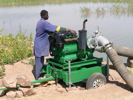
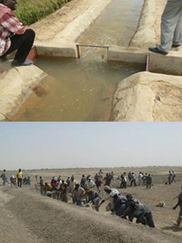
Village irrigation schemes provide irrigation for areas of between 20 and 40 hectares, surrounded by low earthen dikes. The system includes a stilling basin, which receives water from a mobile motor pump, a main channel, secondary channels and irrigation ditches. The scheme gives total control over the water available in the area, using a motor pump to move it around the system. The channels are open earth, and stretches where infiltration is high are lined with riprap. The structures are made of concrete. Village irrigation schemes require a source of water, and are therefore generally located along rivers or near permanent bodies of water.
Irrigation systems of this kind were constructed in Mali after the droughts in the 1970s under numerous development projects implemented to increase rice and wheat production. Between 1996 and 2010, for example, the IPRODI project established 450 irrigation schemes in northern Mali, creating an irrigated area of over 13,000 ha farmed by 55,000 farmers.
The water is pumped into the stilling basin and driven by the force of gravity into the main channel and the secondary and tertiary channels to the plots of individual users. Village irrigation schemes are an effective means of expanding the area of irrigated farmland and increasing production. As they permit the total control of the water available, farmers are practically unaffected by variations in rainfall, as long as the water source remains available. They therefore guarantee the production of food crops and straw for livestock. Village irrigation schemes create new irrigated farmland, which enable farmers to achieve high rice yields: around 6 tonnes per hectare. With an average price of 125 CFA francs a kilo for paddy rice, the value of output per hectare is around 750,000 CFA francs. Profit is estimated at around 300,000 CFA francs per hectare. At some sites, a second harvest is possible. Other plots are used for market gardening, with the production of onions, tomatoes, herbs, spices, etc. After the crops have been harvested, animals are allowed to graze on the plots.
The process to select an area to be developed begins with a request submitted by the community through the commune authorities. A feasibility study is conducted to determine potentially viable sites. The final choice is made in consultation with the regional and commune authorities and the villages concerned and in accordance with the financial resources available. The highly labour intensive approach is used, with beneficiaries participating in the construction work. The beneficiaries receive support from a project to plan and construct the irrigation system, purchase and install the pumping units (with financial contribution), purchase the tools and establish a start-up fund for the first season. Two technicians are trained per scheme. The village irrigation systems are operated and maintained by the beneficiaries and their management committee. The management committee must set up an operating and maintenance fund to purchase fuel and carry out any repairs. Farmers are required to pay a charge of seven sacks of paddy rice (around a third of their harvest) into the fund. In this way, the pumping units can be replaced after a number of years.
Those who participated in the construction work are given preference when the plots are distributed among the village’s families. A quarter-of-a-hectare plot is assigned to each ‘able-bodied person’ who participated in the work to construct the system. The total area assigned to each family therefore depends on the number of able-bodied people in the household. Once the system is in operation, technical services provide support to farmers for a time to teach them adapted farming practices.
2.3 Fotografías de la Tecnología
Galería de medios
2.5 País/ región/ lugares donde la Tecnología fue aplicada y que se hallan comprendidos por esta evaluación
País:
Mali
Región/ Estado/ Provincia:
Mali, Burkina Faso
Especifique la difusión de la Tecnología:
- distribuida parejamente sobre un área
Si se desconoce el área precisa, indique el área aproximada cubierta:
- 100-1,000 km2
Comentarios:
Between 1996 and 2010, for example, the IPRODI project established 450 irrigation schemes in northern Mali, creating an irrigated area of over 13,000 ha farmed by 55,000 farmers. In Mali, there are numerous village irrigation schemes in the Inner Niger Delta and along the banks of the river Niger.
2.6 Fecha de la implementación
Si no se conoce el año preciso, indique la fecha aproximada:
- 10-50 años atrás
2.7 Introducción de la Tecnología
Especifique cómo se introdujo la Tecnología:
- mediante proyectos/ intervenciones externas
Comentarios (tipo de proyecto, etc.):
Developed, implemented and disseminated as part of projects and programmes undertaken from the 1980s onwards to combat desertification and improve natural resource management. Implemented by GIZ (German Federal Enterprise for International Cooperation), and the project to rehabilitate dams and tracks (PRBP) and the Mali north programme (PMN).
Irrigation systems of this kind were constructed in Mali after the droughts in the 1970s under numerous development projects implemented to increase rice and wheat production. Between 1996 and 2010, for example, the IPRODI project established 450 irrigation schemes in northern Mali, creating an irrigated area of over 13,000 ha farmed by 55,000 farmers.
3. Clasificación de la Tecnología MST
3.1 Propósito(s) principal(es) de la Tecnología MST
- mejorar la producción
- crear impacto económico benéfico
3.2 Tipo(s) actuales de uso de la tierra donde se aplica la Tecnología

Tierras cultivadas
- Cosecha anual
Número de temporadas de cultivo por año:
- 1
Especifique:
Longest growing period in days: 120, Longest growing period from month to month: August to October
Comentarios:
Major land use problems (compiler’s opinion): unequal distribution of irrigation water, fertility decline, Constraints of common grazing land, Constraints of forested government-owned land or commons
3.4 Provisión de agua
Provisión de agua para la tierra donde se aplica la Tecnología:
- mixta de secano – irrigada
3.5 Grupo MST al que pertenece la Tecnología
- Manejo de irrigación: (incl. provisión de agua, invernaderos)
- manejo de agua superficial (manantial, río, lagos, mar):
3.6 Medidas MST que componen la Tecnología

medidas estructurales
- S3: Acequias graduadas, canales, vías fluviales
- S11: Otros
Comentarios:
Specification of other structural measures: irrigation scheme
3.7 Principales tipos de degradación de la tierra encarados con la Tecnología

deterioro químico del suelo
- Cn: reducción de la fertilidad y contenido reducido de la materia orgánica del suelo (no ocasionados por la erosión)

degradación biológica
- Bc: reducción de la cobertura vegetal del suelo

degradación del agua
- Ha: aridificación
- Hg: cambio en nivel de aguas subterráneas/ nivel de acuífero
Comentarios:
Main causes of degradation: crop management (annual, perennial, tree/shrub), floods, droughts, population pressure, land tenure
3.8 Prevención, reducción o restauración de la degradación de la tierra
Especifique la meta de la Tecnología con relación a la degradación de la tierra:
- restaurar/ rehabilitar tierra severamente degradada
4. Especificaciones técnicas, actividades de implementación, insumos y costos
4.1 Dibujo técnico de la Tecnología
Especificaciones técnicas (relacionadas al dibujo técnico):
Technical knowledge required for field staff / advisors: high
Technical knowledge required for land users: low
Main technical functions: control of dispersed runoff: retain / trap, control of concentrated runoff: retain / trap, control of concentrated runoff: drain / divert, increase of infiltration, increase / maintain water stored in soil, increase of groundwater level / recharge of groundwater, water harvesting / increase water supply, water spreading
Secondary technical functions: control of dispersed runoff: impede / retard, control of concentrated runoff: impede / retard, improvement of ground cover, increase in organic matter, increase of biomass (quantity)
4.3 Actividades de establecimiento
| Actividad | Momento (estación) | |
|---|---|---|
| 1. | request submitted by the community through the commune authorities | |
| 2. | A feasibility study is conducted to determine potentially viable sites | |
| 3. | final choice is made in consultation with the regional and commune authorities and the villages concerned and in accordance with the financial resources available | |
| 4. | beneficiaries participate in the construction work: construct the irrigation system, purchase and install the pumping units, purchase the tools and establish a start-up fund for the first season. |
4.4 Costos e insumos necesarios para el establecimiento
| Especifique insumo | Unidad | Cantidad | Costos por unidad | Costos totales por insumo | % de los costos cubiertos por los usuarios de las tierras | |
|---|---|---|---|---|---|---|
| Otros | total construction | 1,0 | 2893,14 | 2893,14 | 100,0 | |
| Costos totales para establecer la Tecnología | 2893,14 | |||||
| Costos totales para establecer la Tecnología en USD | 2893,14 | |||||
4.5 Actividades de establecimiento/ recurrentes
| Actividad | Momento/ frequencia | |
|---|---|---|
| 1. | pumping units can be replaced after a number of years |
4.7 Factores más determinantes que afectan los costos:
Describa los factores más determinantes que afectan los costos:
The cost of implementing a village irrigation scheme is around 1.5 million CFA francs per hectare.
5. Entorno natural y humano
5.1 Clima
Lluvia anual
- < 250 mm
- 251-500 mm
- 501-750 mm
- 751-1,000 mm
- 1,001-1,500 mm
- 1,501-2,000 mm
- 2,001-3,000 mm
- 3,001-4,000 mm
- > 4,000 mm
Zona agroclimática
- semi-árida
Thermal climate class: subtropics
5.2 Topografía
Pendientes en promedio:
- plana (0-2 %)
- ligera (3-5%)
- moderada (6-10%)
- ondulada (11-15%)
- accidentada (16-30%)
- empinada (31-60%)
- muy empinada (>60%)
Formaciones telúricas:
- meseta/ planicies
- cordilleras
- laderas montañosas
- laderas de cerro
- pies de monte
- fondo del valle
Zona altitudinal:
- 0-100 m s.n.m.
- 101-500 m s.n.m.
- 501-1,000 m s.n.m
- 1,001-1,500 m s.n.m
- 1,501-2,000 m s.n.m
- 2,001-2,500 m s.n.m
- 2,501-3,000 m s.n.m
- 3,001-4,000 m s.n.m
- > 4,000 m s.n.m
5.3 Suelos
Profundidad promedio del suelo:
- muy superficial (0-20 cm)
- superficial (21-50 cm)
- moderadamente profunda (51-80 cm)
- profunda (81-120 cm)
- muy profunda (>120 cm)
Textura del suelo (capa arable):
- mediana (limosa)
- fina/ pesada (arcilla)
5.4 Disponibilidad y calidad de agua
Agua subterránea:
5-50 m
Disponibilidad de aguas superficiales:
mediana
Comentarios y especificaciones adicionales sobre calidad y cantidad de agua:
Groundwater table: > 10 m
Availability of surface water: surface runoff generated by limited but intense rainfalls
5.5 Biodiversidad
Diversidad de especies:
- baja
5.6 Las características de los usuarios de la tierra que aplican la Tecnología
Nivel relativo de riqueza:
- muy pobre
- pobre
Nivel de mecanización:
- trabajo manual
- tracción animal
Género:
- hombres
Indique otras características relevantes de los usuarios de las tierras:
Population density: 10-50 persons/km2
Annual population growth: 3% - 4% (mostly poor households below poverty line).
Off-farm income specification: men migrate temporarily or permanently to cities for off-farm income
5.7 Área promedio de la tierra usada por usuarios de tierra que aplican la Tecnología
- < 0.5 ha
- 0.5-1 ha
- 1-2 ha
- 2-5 ha
- 5-15 ha
- 15-50 ha
- 50-100 ha
- 100-500 ha
- 500-1,000 ha
- 1,000-10,000 ha
- > 10,000 ha
¿Esto se considera de pequeña, mediana o gran escala (refiriéndose al contexto local)?
- pequeña escala
5.8 Tenencia de tierra, uso de tierra y derechos de uso de agua
Tenencia de tierra:
- estado
Derechos de uso de tierra:
- comunitarios (organizado)
Derechos de uso de agua:
- comunitarios (organizado)
Comentarios:
traditional land use rights on fields, communal land on pasture and forest land
5.9 Acceso a servicios e infraestructura
salud:
- pobre
- moderado
- bueno
educación:
- pobre
- moderado
- bueno
asistencia técnica:
- pobre
- moderado
- bueno
empleo (ej. fuera de la granja):
- pobre
- moderado
- bueno
mercados:
- pobre
- moderado
- bueno
energía:
- pobre
- moderado
- bueno
caminos y transporte:
- pobre
- moderado
- bueno
agua potable y saneamiento:
- pobre
- moderado
- bueno
servicios financieros:
- pobre
- moderado
- bueno
6. Impactos y comentarios para concluir
6.1 Impactos in situ demostrados por la Tecnología
Impactos socioeconómicos
Producción
producción de cultivo
producción de forraje
producción animal
riesgo de fracaso de producción
área de producción
Ingreso y costos
ingreso agrario
Impactos socioculturales
seguridad alimentaria/ autosuficiencia
contribution to human well-being
Comentarios/ especifique:
Village irrigation schemes are an effective means of expanding the area of irrigated farmland and increasing production. Farmers are practically unaffected by variations in rainfall, as long as the water source remains available. They therefore guarantee the production of food crops and straw for livestock.
Impactos ecológicos
Ciclo de agua/ escurrimiento de sedimento
cosecha/ recolección de agua
nivel freático/ acuífero
Suelo
humedad del suelo
cubierta del suelo
6.3 Exposición y sensibilidad de la Tecnología al cambio climático gradual y a extremos relacionados al clima/ desastres (desde la percepción de los usuarios de tierras)
Cambio climático gradual
Cambio climático gradual
| Estación | Incremento o reducción | ¿Cómo es que la tecnología soporta esto? | |
|---|---|---|---|
| temperatura anual | incrementó | bien |
Extremos (desastres) relacionados al clima
Desastres climatológicos:
| ¿Cómo es que la tecnología soporta esto? | |
|---|---|
| tormenta de lluvia local | bien |
| tormenta de viento | bien |
Desastres climatológicos
| ¿Cómo es que la tecnología soporta esto? | |
|---|---|
| sequía | bien |
Desastres hidrológicos
| ¿Cómo es que la tecnología soporta esto? | |
|---|---|
| inundación general (río) | bien |
Otras consecuencias relacionadas al clima
Otras consecuencias relacionadas al clima
| ¿Cómo es que la tecnología soporta esto? | |
|---|---|
| periodo reducido de crecimiento | bien |
6.4 Análisis costo-beneficio
¿Cómo se comparan los beneficios con los costos de establecimiento (desde la perspectiva de los usuarios de tierra)?
Ingresos a corto plazo:
positivo
Ingresos a largo plazo:
positivo
¿Cómo se comparan los beneficios con los costos de mantenimiento/ recurrentes (desde la perspectiva de los usuarios de tierra)?
Ingresos a corto plazo:
positivo
Ingresos a largo plazo:
positivo
6.5 Adopción de la Tecnología
Comentarios:
There is a little trend towards spontaneous adoption of the Technology
Between 1996 and 2010, the IPRODI project established 450 irrigation schemes in northern Mali, creating an irrigated area of over 13,000 ha farmed by 55,000 farmers.
The earliest village irrigation schemes implemented under the IPRODI project in Mali are now 15 years old. They are still operating and in good condition. The low investment and maintenance costs and the assimilation of the operating techniques by the farmers ensure high sustainability.
6.7 Fuerzas/ ventajas/ oportunidades de la Tecnología
| Fuerzas/ ventajas/ oportunidades desde la perspectiva del usuario de la tierra |
|---|
| Those who participated in the construction work are given preference when the plots are distributed among the village’s families. |
| Fuerzas/ ventajas/ oportunidades desde la perspectiva del compilador o de otra persona de referencia clave |
|---|
| Village irrigation schemes are an effective means of expanding the area of irrigated farmland and increasing production. |
| Farmers are practically unaffected by variations in rainfall, as long as the water source remains available. They therefore guarantee the production of food crops and straw for livestock. |
| The earliest village irrigation schemes implemented under the IPRODI project in Mali are now 15 years old. They are still operating and in good condition. The low investment and maintenance costs and the assimilation of the operating techniques by the farmers ensure high sustainability. |
| The beneficiaries use their own funds to replace the pumping units when necessary and to extend the schemes. |
6.8 Debilidades/ desventajas/ riesgos de la Tecnología y formas de sobreponerse a ellos
| Debilidades/ desventajas/ riesgos desde la perspectiva del compilador o de otra persona de referencia clave | ¿Cómo sobreponerse a ellas? |
|---|---|
| A high standard of technical planning (topographical surveying and soil studies) and construction is required to prevent cracks from appearing in the stilling basin or the main channel and avoid the problem of uneven water distribution within the irrigation area. The most serious risk for such schemes is failure of the pumping unit. | A local repair and maintenance service stocking a supply of spare parts must be available to provide assistance when the problem is beyond the abilities of the technicians trained for the scheme by the project. |
| The improved areas sometimes become a source of conflict after the irrigation system has been put in place. | The assessment carried out during the identification and planning stage must take into account any existing and potential conflicts. |
7. Referencias y vínculos
7.1 Métodos/ fuentes de información
- visitas de campo, encuestas de campo
- entrevistas con usuarios de tierras
¿Cuándo se compilaron los datos (en el campo)?
01/07/2012
7.2 Vínculos a las publicaciones disponibles
Título, autor, año, ISBN:
Good Practices in Soil and Water Conservation. A contribution to adaptation and farmers´ resilience towards climate change in the Sahel. Published by GIZ in 2012.
¿Dónde se halla disponible? ¿Costo?
http://agriwaterpedia.info/wiki/Main_Page
Vínculos y módulos
Expandir todo Colapsar todosVínculos
No hay vínculos
Módulos
No se hallaron módulos