Graded Soil bund [Ethiopie]
- Création :
- Mise à jour :
- Compilateur : Unknown User
- Rédacteur : –
- Examinateur : Fabian Ottiger
Yafer Erken (Amharic)
technologies_1060 - Ethiopie
Voir les sections
Développer tout Réduire tout1. Informations générales
1.2 Coordonnées des personnes-ressources et des institutions impliquées dans l'évaluation et la documentation de la Technologie
Personne(s)-ressource(s) clé(s)
Spécialiste GDT:
Tadel Getachew
Office of Agriculture and Rural Development
Wobe Kebele DA, Motta, P.O.Box 31
Ethiopie
Nom du ou des institutions qui ont facilité la documentation/ l'évaluation de la Technologie (si pertinent)
Ministry of Agriculture and Rural Development of Ethiopia (Ministry of Agriculture and Rural Development) - Ethiopie1.3 Conditions relatives à l'utilisation par WOCAT des données documentées
Quand les données ont-elles été compilées (sur le terrain)?
10/11/2005
Le compilateur et la(les) personne(s) ressource(s) acceptent les conditions relatives à l'utilisation par WOCAT des données documentées:
Oui
2. Description de la Technologie de GDT
2.1 Courte description de la Technologie
Définition de la Technologie:
It is an embankment of soil with no gradient along the contour and stablized with grasses, tree/shrub plant species.
2.2 Description détaillée de la Technologie
Description:
The technology cosists of an embankment of soil accross the slope, cutoff drains constructed at a given interval, water ways for disposing runoff from the bunds and cutoff drains, vegetative measures and agronomic practices on cultivated lands. The structures are laid out at a gradient of 1% in order to safely drain excess water. The immidiate result expected is the control of soil erosion, well drained soils control land degradation, decrease slope length and angle and then sustain productivity. The mantainance is frequently done by removing the silt from the channel and repairing the broken part of the bunds and also stablize the bund by planting. The technology is suitable to high rainfall area where crop fields experience seasonal waterlogging. The surplus water needs to be drained by the help of graded channels of smaller gradients. The channels should be properly constructed in a way no channel scour or sediment deposition takes place. Cutoff drains need to be placed at given interval to reinforce the graded bunds. Waterways are paved with stone to avoid channel scour because of the higher gradients involved in waterway construction.
2.5 Pays/ région/ lieux où la Technologie a été appliquée et qui sont couverts par cette évaluation
Pays:
Ethiopie
Région/ Etat/ Province:
Amhara
Autres spécifications du lieu:
Hulet Ejju Enese
Map
×2.6 Date de mise en œuvre de la Technologie
Si l'année précise est inconnue, indiquez la date approximative: :
- il y a moins de 10 ans (récemment)
2.7 Introduction de la Technologie
Spécifiez comment la Technologie a été introduite: :
- par le biais de projets/ d'interventions extérieures
Commentaires (type de projet, etc.) :
The technology was practiced by land users but not designed properly. It is the result of modifications of traditional technologies and adding some new elements improved techniques.
3. Classification de la Technologie de GDT
3.1 Principal(aux) objectif(s) de la Technologie
- améliorer la production
- réduire, prévenir, restaurer les terres dégradées
3.2 Type(s) actuel(s) d'utilisation des terres, là où la Technologie est appliquée

Terres cultivées
- Cultures annuelles
Principales cultures (vivrières et commerciales):
Major cash crop annual cropping: Teff, wheat
Major food crop annual cropping: Teff, maize
Major cash crop tree and shrub cropping: Eucalyptus
Major food product livestock: Meat, milk
Major other purpose of livestock: Sale of live animals

Pâturages
Pâturage extensif:
- Semi-nomadisme/ pastoralisme
Commentaires:
Major land use problems (compiler’s opinion): expansion of gullies, loss of top soil, fertility decline/poor land productivity and free grazing.
Major land use problems (land users’ perception): decrease productivity, gullies expansion, unable to practice relay cropping.
Semi-nomadism / pastoralism: on communal grazing lands
Grazingland comments: Livestock production is decreasing because of decreasing grazing land and its productivity.
Type of cropping system and major crops comments: Teff-vetch, teff-wheat-maize-teff
3.3 Informations complémentaires sur l'utilisation des terres
Approvisionnement en eau des terres sur lesquelles est appliquée la Technologie:
- pluvial
Commentaires:
Water supply: Also mixed rainfed - irrigated and post-flooding
Précisez:
Longest growing period in days: 240 Longest growing period from month to month: Apr - Oct
3.4 Groupe de GDT auquel appartient la Technologie
- mesures en travers de la pente
3.5 Diffusion de la Technologie
Spécifiez la diffusion de la Technologie:
- répartie uniformément sur une zone
Si la Technologie est uniformément répartie sur une zone, indiquez la superficie couverte approximative:
- 10-100 km2
Commentaires:
Total area covered by the SLM Technology is 78.69 m2.
Soil bund is applied in combination with cutoff drain, water ways and plantations.
3.6 Mesures de GDT constituant la Technologie
3.7 Principaux types de dégradation des terres traités par la Technologie

érosion hydrique des sols
- Wt: perte de la couche superficielle des sols (couche arable)/ érosion de surface
- Wg: ravinement/ érosion en ravines

dégradation chimique des sols
- Cn: baisse de la fertilité des sols et réduction du niveau de matière organique (non causée par l’érosion)
Commentaires:
Main type of degradation addressed: Wt: loss of topsoil / surface erosion
Secondary types of degradation addressed: Wg: gully erosion / gullying, Cn: fertility decline and reduced organic matter content
3.8 Prévention, réduction de la dégradation ou réhabilitation des terres dégradées
Spécifiez l'objectif de la Technologie au regard de la dégradation des terres:
- prévenir la dégradation des terres
- réduire la dégradation des terres
Commentaires:
Main goals: mitigation / reduction of land degradation
Secondary goals: prevention of land degradation
4. Spécifications techniques, activités, intrants et coûts de mise en œuvre
4.1 Dessin technique de la Technologie
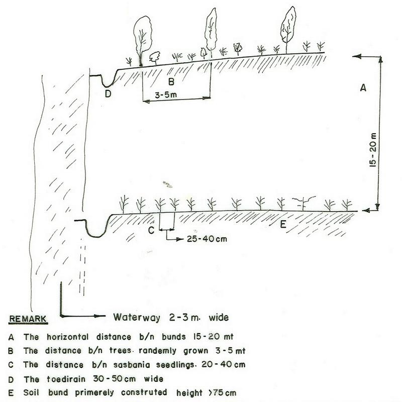
4.2 Spécification/ explications techniques du dessin technique
Amhara
Technical knowledge required for field staff / advisors: high
Technical knowledge required for land users: moderate
Main technical functions: control of concentrated runoff: retain / trap
Secondary technical functions: improvement of ground cover, increase / maintain water stored in soil, water harvesting / increase water supply
Better crop cover
Material/ species: teff, wheat
Remarks: broad casting
Relay cropping
Material/ species: vetch
Remarks: broad casting
Contour planting / strip cropping
Material/ species: maize
Remarks: 40cm between rows & 20 cm between plants
Agronomic measure: removing less vegetation cover
Material/ species: wheat
Quantity/ density: 40%
Remarks: broad casting
Manure / compost / residues
Material/ species: cow dung, compost
Mineral (inorganic) fertilizers
Material/ species: DAP, UREA
Remarks: 1 qt. DAP & 0.5 qt UREA
Rotations / fallows
Material/ species: on grass lands
Remarks: at least 1 year rotation
Contour ridging
Remarks: using BBM
Aligned: -graded strips
Vegetative material: T : trees / shrubs
Number of plants per (ha): 4000
Vertical interval between rows / strips / blocks (m): 1
Spacing between rows / strips / blocks (m): 20
Vertical interval within rows / strips / blocks (m): 0.25
Width within rows / strips / blocks (m): 0.5
Scattered / dispersed
Vegetative material: T : trees / shrubs
Number of plants per (ha): 10000
Spacing between rows / strips / blocks (m): 1
Vertical interval within rows / strips / blocks (m): 1
Width within rows / strips / blocks (m): 1
Trees/ shrubs species: acacia, saligna,
Fruit trees / shrubs species: mango, guava, papaya
Perennial crops species: coffee
Grass species: local grasses, vetiver, elephant grass
Slope (which determines the spacing indicated above): 6.00%
If the original slope has changed as a result of the Technology, the slope today is (see figure below): 4.00%
Gradient along the rows / strips: 1.00%
Waterway
Spacing between structures (m): 200
Depth of ditches/pits/dams (m): 0.7
Width of ditches/pits/dams (m): 3
Length of ditches/pits/dams (m): 500
Height of bunds/banks/others (m): 0.8
Width of bunds/banks/others (m): 1
Length of bunds/banks/others (m): 500
Bund/ bank: graded
Vertical interval between structures (m): 1-2.5
Spacing between structures (m): 20
Depth of ditches/pits/dams (m): 0.3
Width of ditches/pits/dams (m): 0.5
Length of ditches/pits/dams (m): 150
Height of bunds/banks/others (m): 0.75
Width of bunds/banks/others (m): 1
Length of bunds/banks/others (m): 150
Structural measure: diversion ditch / cut-off drain
Vertical interval between structures (m): 50
Spacing between structures (m): 500
Depth of ditches/pits/dams (m): 0.5
Width of ditches/pits/dams (m): 1
Length of ditches/pits/dams (m): 250
Height of bunds/banks/others (m): 0.8
Width of bunds/banks/others (m): 1
Length of bunds/banks/others (m): 250
Construction material (earth): soil dug out from the ditches and piled as embankment
Construction material (stone): stone is used for paving the water ways
Construction material (wood): used for constructing checkdams
Slope (which determines the spacing indicated above): 6%
If the original slope has changed as a result of the Technology, the slope today is: 4%
Lateral gradient along the structure: 1%
Vegetation is used for stabilisation of structures.
Other type of management: change of management / intensity level - protect the structure from breaching.
4.3 Informations générales sur le calcul des intrants et des coûts
autre/ monnaie nationale (précisez):
Birr
Indiquer le taux de change du dollars en monnaie locale (si pertinent): 1 USD= :
8,6
Indiquez le coût salarial moyen de la main d'œuvre par jour:
0.56
4.4 Activités de mise en place/ d'établissement
| Activité | Type de mesures | Calendrier | |
|---|---|---|---|
| 1. | cultivation/weeding | Végétale | |
| 2. | collecting seedlings/seed | Végétale | onset of rain |
| 3. | transplanting/sowing on bunds | Végétale | rainy season |
| 4. | survey the line of embankment | Structurel | dry season |
| 5. | construct bunds, cutoff drai and waterways | Structurel | dry season |
| 6. | planting the structures | Structurel | rainy season |
4.5 Coûts et intrants nécessaires à la mise en place
| Spécifiez les intrants | Unité | Quantité | Coûts par unité | Coût total par intrant | % des coût supporté par les exploitants des terres | |
|---|---|---|---|---|---|---|
| Main d'œuvre | Labour | ha | 1,0 | 99,0 | 99,0 | 100,0 |
| Equipements | Animal traction | ha | 1,0 | 37,0 | 37,0 | 100,0 |
| Matériel végétal | Seeds | ha | 1,0 | 12,0 | 12,0 | 100,0 |
| Engrais et biocides | Fertilizer | ha | 1,0 | 55,0 | 55,0 | 100,0 |
| Coût total de mise en place de la Technologie | 203,0 | |||||
Commentaires:
Duration of establishment phase: 24 month(s)
4.6 Activités d'entretien/ récurrentes
| Activité | Type de mesures | Calendrier/ fréquence | |
|---|---|---|---|
| 1. | minimum tillage | Agronomique | during planting / each cropping season |
| 2. | contour tillage | Agronomique | dry season / each cropping season |
| 3. | relay cropping | Agronomique | after 1st harvest / each cropping season |
| 4. | manuring | Agronomique | after 1st plough / each cropping season |
| 5. | mineral fertilizer | Agronomique | during sowing / each cropping season |
| 6. | fencing | Végétale | during harvesting /once |
| 7. | replanting | Végétale | rainy season / |
| 8. | pollarding | Végétale | before raining / |
| 9. | clearing the ditches | Structurel | onset of rain/as required |
| 10. | strengthning (maintain) the embankment | Structurel | onset of rain/as required |
| 11. | improve vegetative cover | Structurel | rainy season/ |
4.7 Coûts et intrants nécessaires aux activités d'entretien/ récurrentes (par an)
| Spécifiez les intrants | Unité | Quantité | Coûts par unité | Coût total par intrant | % des coût supporté par les exploitants des terres | |
|---|---|---|---|---|---|---|
| Main d'œuvre | Labour | ha | 1,0 | 54,0 | 54,0 | 100,0 |
| Equipements | Animal traction | ha | 1,0 | 34,0 | 34,0 | 100,0 |
| Matériel végétal | Seeds | ha | 1,0 | 12,0 | 12,0 | 100,0 |
| Engrais et biocides | Fertilizer | ha | 1,0 | 55,0 | 55,0 | 100,0 |
| Coût total d'entretien de la Technologie | 155,0 | |||||
Commentaires:
The calculation is for 1 ha land in SWC area, where the first year construction of SWC technology with normal cropping (Teff) production and recurrent cost is calculated for the second year for the same plot of land and production system.
4.8 Facteurs les plus importants affectant les coûts
Décrivez les facteurs les plus importants affectant les coûts :
labour, slope
5. Environnement naturel et humain
5.1 Climat
Précipitations annuelles
- < 250 mm
- 251-500 mm
- 501-750 mm
- 751-1000 mm
- 1001-1500 mm
- 1501-2000 mm
- 2001-3000 mm
- 3001-4000 mm
- > 4000 mm
Spécifications/ commentaires sur les précipitations:
1001-1500 mm (ranked 1, around 1100 mm)
751-1000 mm (ranked 2, low areas)
Zone agro-climatique
- subhumide
some crops have LGP >270
5.2 Topographie
Pentes moyennes:
- plat (0-2 %)
- faible (3-5%)
- modéré (6-10%)
- onduleux (11-15%)
- vallonné (16-30%)
- raide (31-60%)
- très raide (>60%)
Reliefs:
- plateaux/ plaines
- crêtes
- flancs/ pentes de montagne
- flancs/ pentes de colline
- piémonts/ glacis (bas de pente)
- fonds de vallée/bas-fonds
Zones altitudinales:
- 0-100 m
- 101-500 m
- 501-1000 m
- 1001-1500 m
- 1501-2000 m
- 2001-2500 m
- 2501-3000 m
- 3001-4000 m
- > 4000 m
Commentaires et précisions supplémentaires sur la topographie:
Altitudinal zone: 2001-2500 m a.s.l. (The SWC area is within this range)
Slopes on average: Also moderate (ranked 2) and hilly (ranked 3)
5.3 Sols
Profondeur moyenne du sol:
- très superficiel (0-20 cm)
- superficiel (21-50 cm)
- modérément profond (51-80 cm)
- profond (81-120 cm)
- très profond (>120 cm)
Texture du sol (de la couche arable):
- moyen (limoneux)
- fin/ lourd (argile)
Si disponible, joignez une description complète du sol ou précisez les informations disponibles, par ex., type de sol, pH/ acidité du sol, capacité d'échange cationique, azote, salinité, etc.
Soil depth on average: Also deep (ranked 2) and shallow (ranked 3)
Soil texture: Medium (ranked 1, major component is clay loam) and fine/heavy (ranked 2)
Soil fertility: Medium (ranked 1, use of chemical fertilizer is increasing every year), low (ranked 2) and very low (ranked 3)
Soil drainage/infiltration: Medium (ranked 1), poor (ranked 2) and good (ranked 3)
Soil water storage capacity: High (ranked 1), low (ranked 2, ground water level is decreasing every year) and very low (ranked 3)
5.6 Caractéristiques des exploitants des terres appliquant la Technologie
Orientation du système de production:
- subsistance (auto-approvisionnement)
- mixte (de subsistance/ commercial)
Revenus hors exploitation:
- moins de 10% de tous les revenus
Niveau relatif de richesse:
- pauvre
- moyen
Niveau de mécanisation:
- travail manuel
- traction animale
Indiquez toute autre caractéristique pertinente des exploitants des terres:
Population density: 200-500 persons/km2
Annual population growth: 2% - 3%
35% of the land users are average wealthy and own 40% of the land (they take care of their land).
40% of the land users are poor and own 35% of the land (they construct SWC but no follow up).
25% of the land users are poor and own 25% of the land (some times they rent out their land for others).
Off-farm income specification: Farmers have so far not been engaged in any type off-farm activites in the area.
Level of mechanization: Animal traction (ranked 1, local plough) and manual work (ranked 2)
Marekt orientation: Subsistence (ranked 1) and mixed (ranked 2, some crops and livestock products)
5.7 Superficie moyenne des terres détenues ou louées par les exploitants appliquant la Technologie
- < 0,5 ha
- 0,5-1 ha
- 1-2 ha
- 2-5 ha
- 5-15 ha
- 15-50 ha
- 50-100 ha
- 100-500 ha
- 500-1 000 ha
- 1 000-10 000 ha
- > 10 000 ha
Commentaires:
0.5-1 ha: Most of the young generation are classified under this category. Also grazing land is converted to cultivation
5.8 Propriété foncière, droits d’utilisation des terres et de l'eau
Propriété foncière:
- état
Droits d’utilisation des terres:
- individuel
6. Impacts et conclusions
6.1 Impacts sur site que la Technologie a montrés
Impacts socio-économiques
Production
production agricole
production fourragère
qualité des fourrages
production de bois
surface de production
Commentaires/ spécifiez:
especially for the first 1-2 years
gestion des terres
Commentaires/ spécifiez:
lack of consulting the farmer
Revenus et coûts
revenus agricoles
Impacts socioculturels
institutions communautaires
connaissances sur la GDT/ dégradation des terres
Land border security
Commentaires/ spécifiez:
Bunds are baundary of farm plots
Impacts écologiques
Cycle de l'eau/ ruissellement
ruissellement de surface
Quantité avant la GDT:
50
Quantité après la GDT:
30
drainage de l'excès d'eau
Sols
humidité du sol
couverture du sol
perte en sol
Commentaires/ spécifiez:
Unless improper design
matière organique du sol/ au dessous du sol C
Autres impacts écologiques
Soil fertility
Biodiversity
6.2 Impacts hors site que la Technologie a montrés
inondations en aval
pollution des rivières/ nappes phréatiques
sédiments (indésirables) transportés par le vent
6.4 Analyse coûts-bénéfices
Quels sont les bénéfices comparativement aux coûts de mise en place (du point de vue des exploitants des terres)?
Rentabilité à court terme:
légèrement positive
Rentabilité à long terme:
très positive
Quels sont les bénéfices comparativement aux coûts d'entretien récurrents (du point de vue des exploitants des terres)?
Rentabilité à court terme:
positive
Rentabilité à long terme:
très positive
6.5 Adoption de la Technologie
Commentaires:
Comments on acceptance with external material support: estimates
100% of land user families have adopted the Technology without any external material support
Comments on spontaneous adoption: survey results
There is a moderate trend towards spontaneous adoption of the Technology
Comments on adoption trend: In the SWC area more than 75% of the households adopted the technology. They include stone walls to reinforce soil bunds. Stone walls have the disadvantage of harbouring rodents and hence soil bunds are preferred.
6.7 Points forts/ avantages/ possibilités de la Technologie
| Points forts/ avantages/ possibilités du point de vue de l'exploitant des terres |
|---|
| protect the land from soil erosion |
| Points forts/ avantages/ possibilités du point de vue du compilateur ou d'une autre personne ressource clé |
|---|
|
control loss of top soil and water and enhances sustainable production. How can they be sustained / enhanced? proper layout, integrated with other techniques and modification based on farmers intersts. |
| suficient soil moisture retention in the lower altitudes. |
6.8 Faiblesses/ inconvénients/ risques de la Technologie et moyens de les surmonter
| Faiblesses/ inconvénients/ risques du point de vue de l’exploitant des terres | Comment peuvent-ils être surmontés? |
|---|---|
| closer bunds are obstacle for farm operation | modify based on farming system local conditions |
| loss of land | make the bund productive |
| rodent and pest | provision of approprate measures |
| runner grass | proper management of the land |
| Faiblesses/ inconvénients/ risques du point de vue du compilateur ou d'une autre personne ressource clé | Comment peuvent-ils être surmontés? |
|---|---|
| area occupied by bund | increase the productivity of land per unit area by planting fruit tree, forage plants on the bund |
Liens et modules
Développer tout Réduire toutLiens
Aucun lien
Modules
Aucun module trouvé