
Contour Tied Trench [Afghanistan]
- Création :
- Mise à jour :
- Compilateur : Aqila Haidery
- Rédacteur : –
- Examinateur : David Streiff
Chuquorak (Dari)
technologies_1661 - Afghanistan
Voir les sections
Développer tout Réduire tout1. Informations générales
1.2 Coordonnées des personnes-ressources et des institutions impliquées dans l'évaluation et la documentation de la Technologie
Nom du ou des institutions qui ont facilité la documentation/ l'évaluation de la Technologie (si pertinent)
HELVETAS (Swiss Intercooperation)1.3 Conditions relatives à l'utilisation par WOCAT des données documentées
Quand les données ont-elles été compilées (sur le terrain)?
03/02/2013
Le compilateur et la(les) personne(s) ressource(s) acceptent les conditions relatives à l'utilisation par WOCAT des données documentées:
Oui
2. Description de la Technologie de GDT
2.1 Courte description de la Technologie
Définition de la Technologie:
Trenches with soil bunds constructed in a tied manner along contour lines to trap surface runoff and sediments from degraded uplands
2.2 Description détaillée de la Technologie
Description:
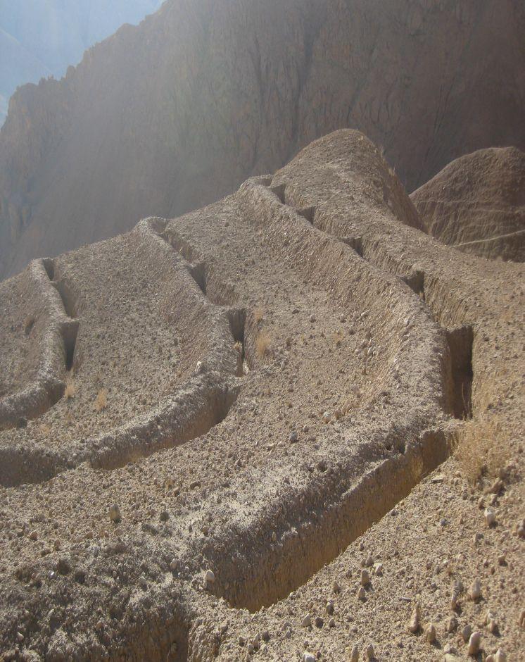
Contour Tied Trenches (CTT) were constructed to trap and retain surface runoff and sediments with the main objective of reducing flash flood risks from the Sou-rakhak watershed which was badly degraded due to overgrazing, excessive cutting of shrubs for fuel wood, rainfed cropping and recurring droughts. The technology was combined with other structural measures like soil bunds, check dams, water ponds, and plantation of fruit, non-fruit trees, fodder crops like alfalfa, Asafoetida and Cumin as cash crops. The watershed is also protected from grazing and shrub cutting by the participating communities. Community bakeries were constructed in the valleys and bio-briquette technology promoted for reducing shrub consump-tion/cutting.
Purpose of the Technology: Continuous Contour Trench (CCT) technology was applied to trap and retain surface runoff and sediments with the main objective of reducing flash flood risks from Sourakhak watershed and preventing damages due to flash floods in the valleys.
Establishment / maintenance activities and inputs: Feasibility studies were conducted and workers from three Community Develop-ment Councils (CDCs) of Roy-e Sang (Kahmard) implemented the construction works based on the technical proposals. The workers were organised by the Sourakhak watershed management committee and they got a daily wage of USD 5 for their labour inputs. About 670 families (276 person days/ha) participated in the construction of CTTs and other technologies.
One supervisor appointed by the communities and a watershed worker from HEL-VETAS Swiss Intercooperation side, both paid by the project, monitored the water-shed works with technical advice from the project staff. The work was carried out in phases and in 4 years (starting 2009) about 65,000 trenches were constructed. About 216 trenches were constructed per hectare and the construction cost was about 1450 USD/ha, which included 1380 USD for labour and 70 USD for tools. The International Swiss Re Award (2009), the Swiss Agency for Development and Cooperation (SDC), HELVETAS Swiss Intercooperation and the participating families financially contributed to the watershed management works.
Natural / human environment: Sourakhak watershed has a semi-arid and temperate climate. The area receives up to 400 mm rainfall (annually) and snow during winter time. The watershed elevation ranges from 2000-3000 m amsl and soil type is sandy-loam to clay type. The land users who applied thsi technology are mostly smallholders. The uplnad areas where the technology was applied is owned by the state, but local communities have long term land use rights.
Sourakhak watershed has a semi-arid and temperate climate. The area receives up to maximum 400 mm rainfall annually in a normal year and snow during winter. About 80% of the rain falls from March to June, with most rain falling in the months of April and May. The watershed is located at an elevation ranging from 2000-3000 m (amsl) and the soil is sandy-loam to clay type. The land users who applied the CTTs are mostly smallholders (with less than 1 ha irrigated land) and they reside in the valley bottoms. The upland areas, where the CTT have been constructed, belong to the state but the local communities have land and water use rights. From a climate change perspective, CTTs will not be much affected by temperature changes or drought. Some trenches could break if there is an extreme rainfall event.
2.3 Photos de la Technologie
Galerie Médias
2.5 Pays/ région/ lieux où la Technologie a été appliquée et qui sont couverts par cette évaluation
Pays:
Afghanistan
Région/ Etat/ Province:
Bamyan Province
Autres spécifications du lieu:
Kahmard district
2.6 Date de mise en œuvre de la Technologie
Si l'année précise est inconnue, indiquez la date approximative: :
- il y a moins de 10 ans (récemment)
2.7 Introduction de la Technologie
Spécifiez comment la Technologie a été introduite: :
- par le biais de projets/ d'interventions extérieures
Commentaires (type de projet, etc.) :
The project started in 2008.
3. Classification de la Technologie de GDT
3.1 Principal(aux) objectif(s) de la Technologie
- réduire, prévenir, restaurer les terres dégradées
- réduire les risques de catastrophes
3.2 Type(s) actuel(s) d'utilisation des terres, là où la Technologie est appliquée

Pâturages
Pâturage extensif:
- Semi-nomadisme/ pastoralisme
Commentaires:
Major land use problems (compiler’s opinion): Depleted soils, poor vegetative cover, deep gullies leading which trigger severe flash floods.
Major land use problems (land users’ perception): Severe flash floods from the degraded watershed.
Future (final) land use (after implementation of SLM Technology): Mixed: Mo: Other
Si l'utilisation des terres a changé en raison de la mise en œuvre de la Technologie, indiquez l'utilisation des terres avant la mise en œuvre de la Technologie:
Grazing land: Ge: Extensive grazing land
3.3 Informations complémentaires sur l'utilisation des terres
Approvisionnement en eau des terres sur lesquelles est appliquée la Technologie:
- pluvial
Nombre de période de croissance par an: :
- 1
Précisez:
Longest growing period in days: 180; Longest growing period from month to month: March to July
3.4 Groupe de GDT auquel appartient la Technologie
- fermeture de zones (arrêt de tout usage, appui à la réhabilitation)
- mesures en travers de la pente
- dérivation et drainage de l'eau
3.5 Diffusion de la Technologie
Spécifiez la diffusion de la Technologie:
- répartie uniformément sur une zone
Si la Technologie est uniformément répartie sur une zone, indiquez la superficie couverte approximative:
- 1-10 km2
Commentaires:
Total area covered by the SLM Technology is 3 km2.
About 65,000 trenches each measuring 5 m in length x 0.7 m in depth and 0.7 m in width (in middle) were constructed manually.
3.6 Mesures de GDT constituant la Technologie

structures physiques
- S4: Fossés isohypses, trous
3.7 Principaux types de dégradation des terres traités par la Technologie

érosion hydrique des sols
- Wt: perte de la couche superficielle des sols (couche arable)/ érosion de surface
- Wo: effets hors-site de la dégradation

dégradation biologique
- Bc: réduction de la couverture végétale
Commentaires:
Secondary types of degradation addressed: Bc: reduction of vegetation cover
Main causes of degradation: over-exploitation of vegetation for domestic use (Shrubs used for fuel), overgrazing (Mainly by sheep and goats), governance / institutional (No management system either by the government or local communities)
Secondary causes of degradation: droughts (Slow recovery of natural vegetation), population pressure, war and conflicts (Cutting of Juniper trees)
3.8 Prévention, réduction de la dégradation ou réhabilitation des terres dégradées
Spécifiez l'objectif de la Technologie au regard de la dégradation des terres:
- restaurer/ réhabiliter des terres sévèrement dégradées
4. Spécifications techniques, activités, intrants et coûts de mise en œuvre
4.1 Dessin technique de la Technologie
Auteur:
Ahmad Ali Sediqi, HELVETAS Swiss Intercooperation
4.2 Spécification/ explications techniques du dessin technique
Technical specifications of Contour Tied Trench with soil bunds constructed at Sourakhak wa-tershed. Fruit and non-fruit trees have been planted at a few selected sites in the watershed as vegetative measures. The plant survival per cent was about 10% due to drought, rodent problem and poor adaptation of the tree saplings brought from a different natural environment. The sites are protected from grazing and shrub cutting leading to better land cover.
The trenches have the capacity to store about 159,250 cu.m of water. Kahmard receives up to 350 mm rainfall per year. Considering catchment area of 3 km2 the trenches can hold all the water if there was 50 mm rain at a time, which is rare.Trench size: 5 m (L), 1m at top and 0.4 m at bottom (W), 0.7 m (D)
Distance between trench in a row = 0.3-0.7 m and spacing between contours = 4-8 m depending on the slope (steeper slopes have less distance)
Soil bund size: 5.5 m (L), 0.7 m/0.4 m (W), 0.5 m (H)
The trenches have the capacity to store about 159,250 cu.m of water. Kahmard receives up to 350 mm rainfall per year. Considering catchment area of 3 km2 the trenches can hold all the water if there was 50 mm rainfall at a time, which is rare.
Location: Afghanistan. Kahmard/Bamyan
Date: 12/12/2012
Technical knowledge required for field staff / advisors: high (Initial stages. It is a new technology for most field staff.)
Technical knowledge required for land users: high (Initial stages. Land users have to learn first where to apply, how to apply and maintain this technology and also the method for preparing contour lines.)
Main technical functions: control of dispersed runoff: retain / trap
Secondary technical functions: reduction of slope length, increase of infiltration
Retention/infiltration ditch/pit, sediment/sand trap
Spacing between structures (m): 4-8
Depth of ditches/pits/dams (m): 0.7
Width of ditches/pits/dams (m): 0.7
Length of ditches/pits/dams (m): 5
Height of bunds/banks/others (m): 0.5
Width of bunds/banks/others (m): 0.7
Length of bunds/banks/others (m): 5.5
4.3 Informations générales sur le calcul des intrants et des coûts
Indiquez la monnaie utilisée pour le calcul des coûts:
- dollars US
Indiquez le coût salarial moyen de la main d'œuvre par jour:
5.00
4.4 Activités de mise en place/ d'établissement
| Activité | Type de mesures | Calendrier | |
|---|---|---|---|
| 1. | construction of trenches | Structurel | summer and autumn |
4.5 Coûts et intrants nécessaires à la mise en place
| Spécifiez les intrants | Unité | Quantité | Coûts par unité | Coût total par intrant | % du coût supporté par les exploitants des terres | |
|---|---|---|---|---|---|---|
| Main d'œuvre | Construction of trenches | persons/day/ha | 276,0 | 5,0 | 1380,0 | 10,0 |
| Equipements | Tools | ha | 1,0 | 70,0 | 70,0 | 90,0 |
| Coût total de mise en place de la Technologie | 1450,0 | |||||
Commentaires:
Duration of establishment phase: 36 month(s)
4.6 Activités d'entretien/ récurrentes
| Activité | Type de mesures | Calendrier/ fréquence | |
|---|---|---|---|
| 1. | Repair trenches | Structurel | Spring/once per year |
4.7 Coûts et intrants nécessaires aux activités d'entretien/ récurrentes (par an)
| Spécifiez les intrants | Unité | Quantité | Coûts par unité | Coût total par intrant | % du coût supporté par les exploitants des terres | |
|---|---|---|---|---|---|---|
| Main d'œuvre | Repair trenches | persons/day/ha | 1,0 | 5,0 | 5,0 | 100,0 |
| Coût total d'entretien de la Technologie | 5,0 | |||||
Commentaires:
Machinery/ tools: Shovel
4.8 Facteurs les plus importants affectant les coûts
Décrivez les facteurs les plus importants affectant les coûts :
Labour
5. Environnement naturel et humain
5.1 Climat
Précipitations annuelles
- < 250 mm
- 251-500 mm
- 501-750 mm
- 751-1000 mm
- 1001-1500 mm
- 1501-2000 mm
- 2001-3000 mm
- 3001-4000 mm
- > 4000 mm
Zone agro-climatique
- semi-aride
Thermal climate class: temperate
5.2 Topographie
Pentes moyennes:
- plat (0-2 %)
- faible (3-5%)
- modéré (6-10%)
- onduleux (11-15%)
- vallonné (16-30%)
- raide (31-60%)
- très raide (>60%)
Reliefs:
- plateaux/ plaines
- crêtes
- flancs/ pentes de montagne
- flancs/ pentes de colline
- piémonts/ glacis (bas de pente)
- fonds de vallée/bas-fonds
Zones altitudinales:
- 0-100 m
- 101-500 m
- 501-1000 m
- 1001-1500 m
- 1501-2000 m
- 2001-2500 m
- 2501-3000 m
- 3001-4000 m
- > 4000 m
5.3 Sols
Profondeur moyenne du sol:
- très superficiel (0-20 cm)
- superficiel (21-50 cm)
- modérément profond (51-80 cm)
- profond (81-120 cm)
- très profond (>120 cm)
Texture du sol (de la couche arable):
- grossier/ léger (sablonneux)
- fin/ lourd (argile)
Matière organique de la couche arable:
- faible (<1%)
Si disponible, joignez une description complète du sol ou précisez les informations disponibles, par ex., type de sol, pH/ acidité du sol, capacité d'échange cationique, azote, salinité, etc.
Soil fertility is low - medium
Soil drainage / infiltration is medium - good
Soil water storage capacity is medium
5.4 Disponibilité et qualité de l'eau
Disponibilité de l’eau de surface:
moyenne
Qualité de l’eau (non traitée):
faiblement potable (traitement nécessaire)
Commentaires et précisions supplémentaires sur la qualité et la quantité d'eau:
Availability of surface water: During rainy seasons
Water quality (untreated): Not good but used for animal drinking water using traditional water harvesting structures
5.5 Biodiversité
Diversité des espèces:
- faible
Commentaires et précisions supplémentaires sur la biodiversité:
Gradually improving
5.6 Caractéristiques des exploitants des terres appliquant la Technologie
Orientation du système de production:
- mixte (de subsistance/ commercial)
Revenus hors exploitation:
- 10-50% de tous les revenus
Individus ou groupes:
- groupe/ communauté
Genre:
- hommes
Indiquez toute autre caractéristique pertinente des exploitants des terres:
Land users applying the Technology are mainly common / average land users
Difference in the involvement of women and men: Women are not allowed to work in these areas due to local customs.
Population density: 10-50 persons/km2
Annual population growth: 2% - 3%
Relative level of wealth: rich, average, poor
10% of the land users are rich.
40% of the land users are average wealthy.
50% of the land users are poor.
Market orientation of production system: Income from selling sheep and goats and items from livestotck products like carpets.
5.7 Superficie moyenne des terres détenues ou louées par les exploitants appliquant la Technologie
- < 0,5 ha
- 0,5-1 ha
- 1-2 ha
- 2-5 ha
- 5-15 ha
- 15-50 ha
- 50-100 ha
- 100-500 ha
- 500-1 000 ha
- 1 000-10 000 ha
- > 10 000 ha
Cette superficie est-elle considérée comme de petite, moyenne ou grande dimension (en se référant au contexte local)?
- petite dimension
5.8 Propriété foncière, droits d’utilisation des terres et de l'eau
Propriété foncière:
- état
Droits d’utilisation des terres:
- communautaire (organisé)
Droits d’utilisation de l’eau:
- communautaire (organisé)
Commentaires:
Land is used by families of three community development councils in Kahmard district as common land
5.9 Accès aux services et aux infrastructures
santé:
- pauvre
- modéré
- bonne
éducation:
- pauvre
- modéré
- bonne
assistance technique:
- pauvre
- modéré
- bonne
emploi (par ex. hors exploitation):
- pauvre
- modéré
- bonne
marchés:
- pauvre
- modéré
- bonne
énergie:
- pauvre
- modéré
- bonne
routes et transports:
- pauvre
- modéré
- bonne
eau potable et assainissement:
- pauvre
- modéré
- bonne
services financiers:
- pauvre
- modéré
- bonne
6. Impacts et conclusions
6.1 Impacts sur site que la Technologie a montrés
Impacts socio-économiques
Production
production fourragère
Commentaires/ spécifiez:
Increase in natural production due to increased moisture and area protection
surface de production
Commentaires/ spécifiez:
As the area is closed for grazing and shrub cutting
Impacts socioculturels
institutions communautaires
Commentaires/ spécifiez:
Work is facilitated by watershed management committee
connaissances sur la GDT/ dégradation des terres
livelihood and human well-being
Commentaires/ spécifiez:
It has reduced flash flood risks. As a result, more area in the valleys is productive and damages to houses, roads, gardens, agriculture land have significantly reduced
Impacts écologiques
Cycle de l'eau/ ruissellement
récolte/ collecte de l'eau
nappes phréatiques/ aquifères
Sols
humidité du sol
Biodiversité: végétale, animale
diversité végétale
6.2 Impacts hors site que la Technologie a montrés
inondations en aval
dommages sur les champs voisins
Commentaires/ spécifiez:
Due to less flash floods
6.3 Exposition et sensibilité de la Technologie aux changements progressifs et aux évènements extrêmes/catastrophes liés au climat (telles que perçues par les exploitants des terres)
Changements climatiques progressifs
Changements climatiques progressifs
| Saison | Type de changements/ extrêmes climatiques | Comment la Technologie fait-elle face à cela? | |
|---|---|---|---|
| températures annuelles | augmente | bien |
Extrêmes climatiques (catastrophes)
Catastrophes météorologiques
| Comment la Technologie fait-elle face à cela? | |
|---|---|
| pluie torrentielle locale | pas bien |
Catastrophes climatiques
| Comment la Technologie fait-elle face à cela? | |
|---|---|
| sécheresse | bien |
Autres conséquences liées au climat
Autres conséquences liées au climat
| Comment la Technologie fait-elle face à cela? | |
|---|---|
| réduction de la période de croissance | bien |
Commentaires:
Stabilize CTTs with vegetative and management measures. Trench size should be based on hydro-meteorological parameters considering possibility of an extreme event occurring.
6.4 Analyse coûts-bénéfices
Quels sont les bénéfices comparativement aux coûts de mise en place (du point de vue des exploitants des terres)?
Rentabilité à court terme:
positive
Rentabilité à long terme:
très positive
Quels sont les bénéfices comparativement aux coûts d'entretien récurrents (du point de vue des exploitants des terres)?
Rentabilité à court terme:
positive
Rentabilité à long terme:
très positive
6.5 Adoption de la Technologie
Commentaires:
100% of land user families have adopted the Technology with external material support
6.7 Points forts/ avantages/ possibilités de la Technologie
| Points forts/ avantages/ possibilités du point de vue de l'exploitant des terres |
|---|
| Reduce flash floods risks |
|
Helps in spring recharge How can they be sustained / enhanced? CTTs should be maintained and combined with vegetation measures for better infiltration. |
| Points forts/ avantages/ possibilités du point de vue du compilateur ou d'une autre personne ressource clé |
|---|
|
Reduce flash floods risks How can they be sustained / enhanced? Maintenance and application of vegetative measures along with the trenches. For Instance planting of perennial forage species on the bunds like Alfalfa, Agropyron and Sainfoin.. |
|
CTTs considered better than staggered contour trench if the purpose is to control flash floods as it can trap more runoff and have less chances of damages How can they be sustained / enhanced? Maintenance and correct implementation is necessary |
|
Helps in the establishment of vegetation due to more soil moisture How can they be sustained / enhanced? Combine with conservation practices like mulching |
|
Potential technology for reducing flash flood risks How can they be sustained / enhanced? More training and awareness about the limitations of this technology - where to apply and where not to apply |
6.8 Faiblesses/ inconvénients/ risques de la Technologie et moyens de les surmonter
| Faiblesses/ inconvénients/ risques du point de vue du compilateur ou d'une autre personne ressource clé | Comment peuvent-ils être surmontés? |
|---|---|
| Soil disturbed during digging and fine clay deposits in the trenches which reduces infiltration | Apply conservation trenches. Planting on the either ends of the trench and soil working to break the clay layering. |
| Establishment costs are high | Initial external support necessary. Linking relief to sustainable land management could be an option. |
| Loss of land for production due to trenching | ntegrate planting of trees and grasses. |
| Trenches break | CTTs must be of right size along the contour lines. Workers must be trained before implementation work and there must be proper supervision. The size of a trench and spacing between trenches should be based on hydro-met parameters. Also, avoid steep sandy (blue) and shallow rocky soil beds |
Liens et modules
Développer tout Réduire toutLiens
Aucun lien
Modules
Aucun module trouvé