Water retention basin, a flood-control reservoir [Slovaquie]
- Création :
- Mise à jour :
- Compilateur : Zuzana Studvova
- Rédacteur : –
- Examinateur : Fabian Ottiger
Polder (Slovak language)
technologies_1675 - Slovaquie
Voir les sections
Développer tout Réduire tout1. Informations générales
1.2 Coordonnées des personnes-ressources et des institutions impliquées dans l'évaluation et la documentation de la Technologie
Nom du projet qui a facilité la documentation/ l'évaluation de la Technologie (si pertinent)
Preventing and Remediating degradation of soils in Europe through Land Care (EU-RECARE )Nom du ou des institutions qui ont facilité la documentation/ l'évaluation de la Technologie (si pertinent)
Slovak University of Technology (Slovak University of Technology) - Slovaquie1.3 Conditions relatives à l'utilisation par WOCAT des données documentées
Le compilateur et la(les) personne(s) ressource(s) acceptent les conditions relatives à l'utilisation par WOCAT des données documentées:
Oui
2. Description de la Technologie de GDT
2.1 Courte description de la Technologie
Définition de la Technologie:
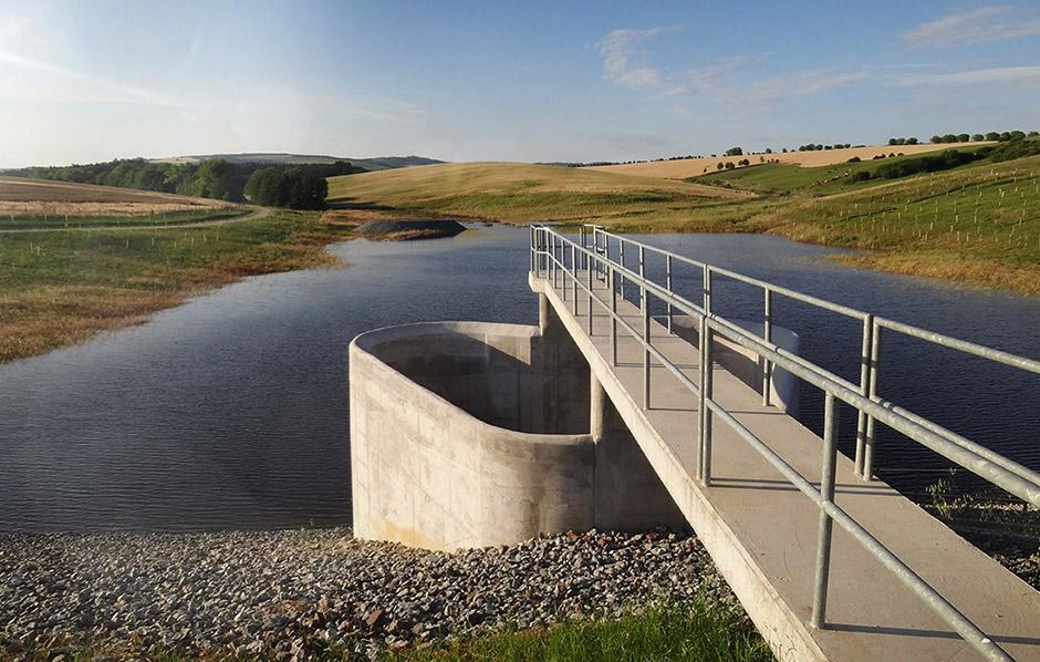
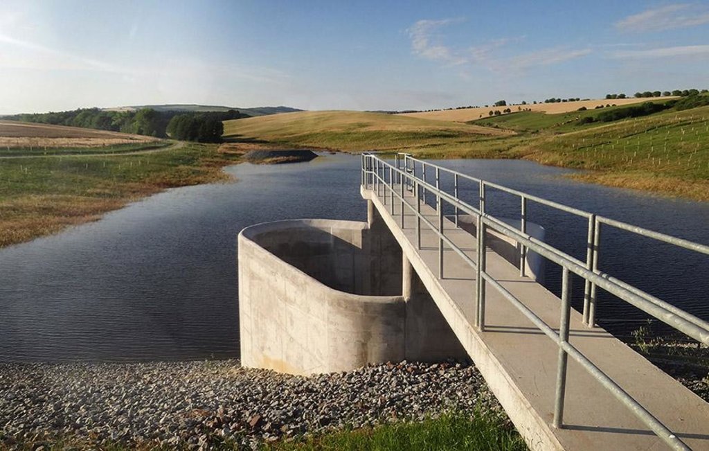
Flood-Control Reservoir - a complex hydraulic facility
2.2 Description détaillée de la Technologie
Description:
The construction is designed to prevent the flooding of the territory located behind the structure, to eliminate the threat of floods caused by storm rainfall and inappropriate farming, and to reduce flow fluctuation.
Purpose of the Technology: The Svacenický creek polder was built to transform Q100 flood waves.
Natural / human environment: The Svacenický creek polder is part of the flood protection of the area, which is located in the west of Slovakia in the cadastral area of the town of Myjava, in the locality of Tura Luka. The town of Myjava has been plagued by frequent floods in recent years, which have resulted in significant material damage, thereby severely hampering the quality of the local residents´ lives.
2.3 Photos de la Technologie
2.5 Pays/ région/ lieux où la Technologie a été appliquée et qui sont couverts par cette évaluation
Pays:
Slovaquie
Région/ Etat/ Province:
Slovakia / Trenčiansky region
Autres spécifications du lieu:
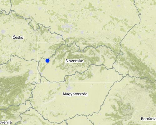
Myjava / Turá Lúka
Map
×2.6 Date de mise en œuvre de la Technologie
Si l'année précise est inconnue, indiquez la date approximative: :
- il y a entre 10-50 ans
2.7 Introduction de la Technologie
Spécifiez comment la Technologie a été introduite: :
- par le biais de projets/ d'interventions extérieures
3. Classification de la Technologie de GDT
3.2 Type(s) actuel(s) d'utilisation des terres, là où la Technologie est appliquée

Terres cultivées
- Cultures annuelles
Commentaires:
Major land use problems (compiler’s opinion): Generation of gulllies.
Major land use problems (land users’ perception): Generation of gulllies and landslides.
Future (final) land use (after implementation of SLM Technology): Other: Ow: Waterways, drainage lines, ponds, dams
Si l'utilisation des terres a changé en raison de la mise en œuvre de la Technologie, indiquez l'utilisation des terres avant la mise en œuvre de la Technologie:
Cropland: Ca: Annual cropping
3.3 Informations complémentaires sur l'utilisation des terres
Approvisionnement en eau des terres sur lesquelles est appliquée la Technologie:
- mixte: pluvial-irrigué
Nombre de période de croissance par an: :
- 1
Précisez:
Longest growing period in days: 180Longest growing period from month to month: April to September
3.4 Groupe de GDT auquel appartient la Technologie
- gestion des eaux de surface (sources, rivières, lacs, mers)
3.5 Diffusion de la Technologie
Spécifiez la diffusion de la Technologie:
- répartie uniformément sur une zone
Si la Technologie est uniformément répartie sur une zone, indiquez la superficie couverte approximative:
- < 0,1 km2 (10 ha)
Commentaires:
The reservoir is situated at the Svacenický Creek.
3.6 Mesures de GDT constituant la Technologie

pratiques végétales
- V1: Couverture d’arbres et d’arbustes
- V2: Herbes et plantes herbacées pérennes

structures physiques
- S5: Barrages/retenues, micro-bassins, étangs
Commentaires:
Main measures: structural measures
Secondary measures: vegetative measures
Type of vegetative measures: scattered / dispersed
3.7 Principaux types de dégradation des terres traités par la Technologie

érosion hydrique des sols
- Wg: ravinement/ érosion en ravines
- Wm: mouvements de masse/ glissements de terrain
Commentaires:
Main type of degradation addressed: Wm: mass movements / landslides
Secondary types of degradation addressed: Wg: gully erosion / gullying
Main causes of degradation: Heavy / extreme rainfall (intensity/amounts), floods
Secondary causes of degradation: soil management, crop management (annual, perennial, tree/shrub)
3.8 Prévention, réduction de la dégradation ou réhabilitation des terres dégradées
Spécifiez l'objectif de la Technologie au regard de la dégradation des terres:
- prévenir la dégradation des terres
Commentaires:
Main goals: prevention of land degradation
4. Spécifications techniques, activités, intrants et coûts de mise en œuvre
4.1 Dessin technique de la Technologie
4.2 Spécification/ explications techniques du dessin technique
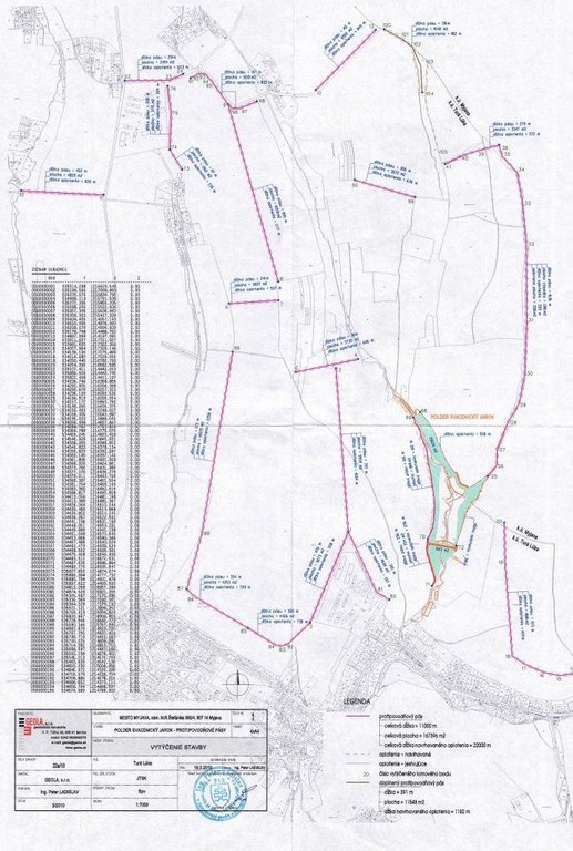
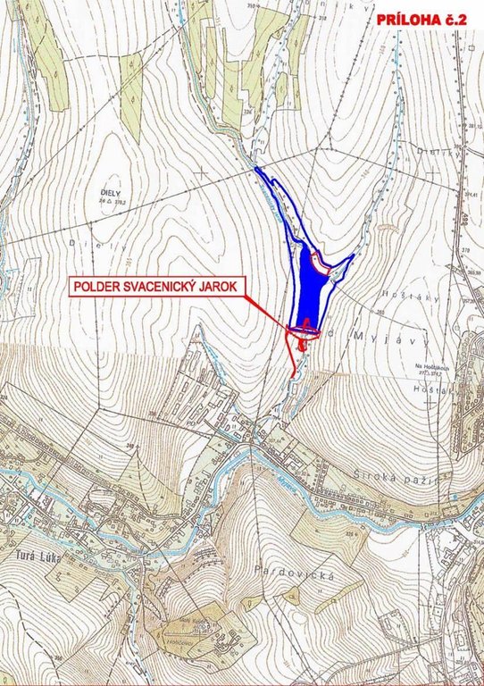
This technical drawing shows where the reservoir is localized. Blue colour presents the reservoir, red represents a complex hydraulic facility that is situated by the polder.
Location: The town of Myjava - the locality of Turá Lúka. Slovakia
Technical knowledge required for field staff / advisors: low
Technical knowledge required for land users: low
Technical knowledge required for Design and construction engineers: high (The preparatory and design documentation is needed.)
Main technical functions: control of concentrated runoff: retain / trap
Secondary technical functions: stabilisation of soil (eg by tree roots against land slides)
Aligned: -linear
Vegetative material: G : grass
Scattered / dispersed
Vegetative material: T : trees / shrubs, F : fruit trees / shrubs
Trees/ shrubs species: together 50 000 plants
Specification of dams/ pans/ ponds: Capacity 215,800m3
Catchment area: 6 km2m2
Beneficial area: 3 ham2
Slope of dam wall inside: -%;
Slope of dam wall outside: -%
Dimensions of spillways: -m
Other specifications: -
Vegetation is used for stabilisation of structures.
4.3 Informations générales sur le calcul des intrants et des coûts
autre/ monnaie nationale (précisez):
euro
Indiquer le taux de change du dollars en monnaie locale (si pertinent): 1 USD= :
0,91
4.7 Coûts et intrants nécessaires aux activités d'entretien/ récurrentes (par an)
Commentaires:
The list of main activities:1/Land purchase (144849.574 USD),2/ Preparatory and design documentation (49305.338 USD), 3/Construction works (2345530.958 USD), 4/Constuction supervision (40135.48 USD), 5/Supporting activities (dissemination 494.55 USD, project management 40098.993 USD).
4.8 Facteurs les plus importants affectant les coûts
Décrivez les facteurs les plus importants affectant les coûts :
The most determinate factors that affect the costs are realization works and material used, and repurchase of land.
5. Environnement naturel et humain
5.1 Climat
Précipitations annuelles
- < 250 mm
- 251-500 mm
- 501-750 mm
- 751-1000 mm
- 1001-1500 mm
- 1501-2000 mm
- 2001-3000 mm
- 3001-4000 mm
- > 4000 mm
Zone agro-climatique
- subhumide
Thermal climate class: temperate
5.2 Topographie
Pentes moyennes:
- plat (0-2 %)
- faible (3-5%)
- modéré (6-10%)
- onduleux (11-15%)
- vallonné (16-30%)
- raide (31-60%)
- très raide (>60%)
Reliefs:
- plateaux/ plaines
- crêtes
- flancs/ pentes de montagne
- flancs/ pentes de colline
- piémonts/ glacis (bas de pente)
- fonds de vallée/bas-fonds
Zones altitudinales:
- 0-100 m
- 101-500 m
- 501-1000 m
- 1001-1500 m
- 1501-2000 m
- 2001-2500 m
- 2501-3000 m
- 3001-4000 m
- > 4000 m
Commentaires et précisions supplémentaires sur la topographie:
Altitudinal zone: 101-500 m a.s.l. (370-400 m a.s.l.)
5.3 Sols
Profondeur moyenne du sol:
- très superficiel (0-20 cm)
- superficiel (21-50 cm)
- modérément profond (51-80 cm)
- profond (81-120 cm)
- très profond (>120 cm)
Texture du sol (de la couche arable):
- moyen (limoneux)
- fin/ lourd (argile)
5.4 Disponibilité et qualité de l'eau
Qualité de l’eau (non traitée):
eau potable
5.6 Caractéristiques des exploitants des terres appliquant la Technologie
Niveau relatif de richesse:
- moyen
Niveau de mécanisation:
- mécanisé/ motorisé
Indiquez toute autre caractéristique pertinente des exploitants des terres:
Population density: 50-100 persons/km2
Market orientation of production system: subsistence (self-supply), mixed (subsistence/ commercial, commercial/ market
5.7 Superficie moyenne des terres détenues ou louées par les exploitants appliquant la Technologie
- < 0,5 ha
- 0,5-1 ha
- 1-2 ha
- 2-5 ha
- 5-15 ha
- 15-50 ha
- 50-100 ha
- 100-500 ha
- 500-1 000 ha
- 1 000-10 000 ha
- > 10 000 ha
Commentaires:
Average area of land owned or leased by land users applying the Technology: Also 1-2 ha
5.8 Propriété foncière, droits d’utilisation des terres et de l'eau
Droits d’utilisation des terres:
- communautaire (organisé)
Commentaires:
Land ownership: state, communal / village, individual, not titled
5.9 Accès aux services et aux infrastructures
santé:
- pauvre
- modéré
- bonne
éducation:
- pauvre
- modéré
- bonne
assistance technique:
- pauvre
- modéré
- bonne
emploi (par ex. hors exploitation):
- pauvre
- modéré
- bonne
marchés:
- pauvre
- modéré
- bonne
énergie:
- pauvre
- modéré
- bonne
routes et transports:
- pauvre
- modéré
- bonne
eau potable et assainissement:
- pauvre
- modéré
- bonne
services financiers:
- pauvre
- modéré
- bonne
6. Impacts et conclusions
6.1 Impacts sur site que la Technologie a montrés
Impacts socioculturels
Improved livelihoods and human well-being
Commentaires/ spécifiez:
The technology had a positive impact on the natural monument river Myjava. These are: - Reduction of catastrophic floods in the Tura Luka profile approx. 10% - Minimum flows also increased water runoff approx. 10%
Impacts écologiques
Biodiversité: végétale, animale
diversité des habitats
Commentaires/ spécifiez:
Destruction of the use of certain habitats
Autres impacts écologiques
Risk towards adverse events
Commentaires/ spécifiez:
Reduced risk of flooding and thereby material damage.
Flood discharge in the Myjava river
Commentaires/ spécifiez:
10 % decrease of flood discharge
Flood discharge in the Svacenický creelk
New possibilities
Commentaires/ spécifiez:
New water reservoir
New habitats
Removal of riparian vegetation
Commentaires/ spécifiez:
Temporary
6.2 Impacts hors site que la Technologie a montrés
flux des cours d'eau fiables et stables en saison sèche
inondations en aval
dommages sur les infrastructures publiques/ privées
6.3 Exposition et sensibilité de la Technologie aux changements progressifs et aux évènements extrêmes/catastrophes liés au climat (telles que perçues par les exploitants des terres)
Changements climatiques progressifs
Changements climatiques progressifs
| Saison | Type de changements/ extrêmes climatiques | Comment la Technologie fait-elle face à cela? | |
|---|---|---|---|
| températures annuelles | augmente | bien |
Extrêmes climatiques (catastrophes)
Catastrophes météorologiques
| Comment la Technologie fait-elle face à cela? | |
|---|---|
| pluie torrentielle locale | bien |
| tempête de vent locale | pas connu |
Catastrophes climatiques
| Comment la Technologie fait-elle face à cela? | |
|---|---|
| sécheresse | bien |
Catastrophes hydrologiques
| Comment la Technologie fait-elle face à cela? | |
|---|---|
| inondation générale (rivière) | bien |
Autres conséquences liées au climat
Autres conséquences liées au climat
| Comment la Technologie fait-elle face à cela? | |
|---|---|
| réduction de la période de croissance | bien |
6.4 Analyse coûts-bénéfices
Commentaires:
No information about maintenance costs was given.
6.7 Points forts/ avantages/ possibilités de la Technologie
| Points forts/ avantages/ possibilités du point de vue du compilateur ou d'une autre personne ressource clé |
|---|
| reduction of catastrophic floods in the Tura Luka profile by approx. 10% |
| change in the landscape´s structure, provides a new landscape element – a water area and newly constructed accompanying greenery |
| Minimum flows increased by approx. 10% |
| The construction of the polder will bring about new and improved conditions for other organisms, as it will create new habitats. |
6.8 Faiblesses/ inconvénients/ risques de la Technologie et moyens de les surmonter
| Faiblesses/ inconvénients/ risques du point de vue du compilateur ou d'une autre personne ressource clé | Comment peuvent-ils être surmontés? |
|---|---|
| During the construction and operations arable land will not be usable. | |
| Construction of the polder will create a new water area, but in terms of the technical design, the construction will not affect the water table in the greater area. | |
| The effects on the air quality during the construction are normally associated with an increased risk of dust (construction, transport), but this will have a short-term impact. | |
| There will be a temporary cessation of the use of certain habitats as a result of the taking of the land. It is expected that during the construction, trees will be cut down or damaged or that those habitats that are located in the bank vegetation of the Svacenicky creek and its immediate vicinity will disappear. This activity will affect approx. 0.35% of the entire length of the original riverbed. The taking of the land may result in injury or death to small mammals. |
7. Références et liens
7.2 Références des publications disponibles
Titre, auteur, année, ISBN:
http://www.enviroportal.sk/sk_SK/eia/detail/polder-svacenicky-jarok-myjava
http://vodotika.sk/projects/polder-svacenicky-jarok/
http://www.vahostav-sk.sk/galeria-vahostav/vodohospodarske-stavby/protipovodnove-ochrany/polder-svacenicky-jarok-myjava
Liens et modules
Développer tout Réduire toutLiens
Aucun lien
Modules
Aucun module trouvé


