Cultivation of Hing (Ferula assa-foetida) in the watershed [Afghanistan]
- Création :
- Mise à jour :
- Compilateur : Aqila Haidery
- Rédacteur : –
- Examinateur : Alexandra Gavilano
Kesht Angoza da abriza
technologies_1306 - Afghanistan
Voir les sections
Développer tout Réduire tout1. Informations générales
1.2 Coordonnées des personnes-ressources et des institutions impliquées dans l'évaluation et la documentation de la Technologie
Spécialiste GDT:
Nom du ou des institutions qui ont facilité la documentation/ l'évaluation de la Technologie (si pertinent)
HELVETAS (Swiss Intercooperation)1.3 Conditions relatives à l'utilisation par WOCAT des données documentées
Le compilateur et la(les) personne(s) ressource(s) acceptent les conditions relatives à l'utilisation par WOCAT des données documentées:
Oui
1.4 Déclaration sur la durabilité de la Technologie décrite
Est-ce que la Technologie décrite ici pose problème par rapport à la dégradation des terres, de telle sorte qu'elle ne peut pas être déclarée comme étant une technologie de gestion durable des terres?
Non
2. Description de la Technologie de GDT
2.1 Courte description de la Technologie
Définition de la Technologie:
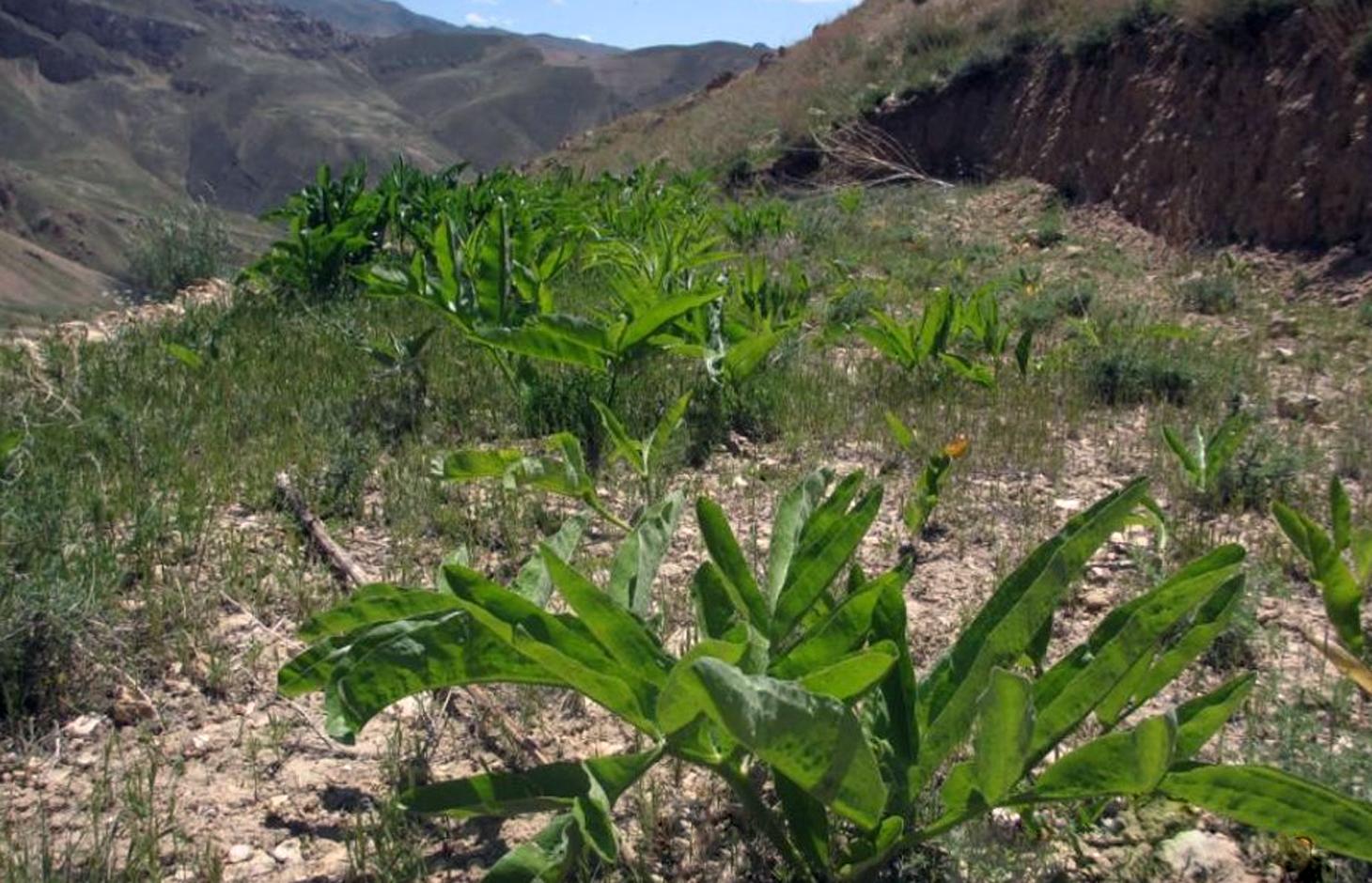
Ferula assa-foetida is an important medicinal plant, a valued cash crop and a native plant of Afghanistan’s range-lands.
2.2 Description détaillée de la Technologie
Description:
Cultivation of hing (Ferula assa-foetida) in watersheds is documented by the Sustainable Land Management Project which is implemented by HELVETAS Swiss Intercooperation and funded by the Swiss Agency for Development and Cooperation (SDC). Ferula assa-foetida, or hing, is a medicinal plant that grows well in shallow sandy and alkaline soils in semi-arid climates and at high altitudes and is a native plant of Afghanistan’s upper catchment areas. Due to the enduring conflict and the consequent breakdown of community-managed grazing in upper catchment areas, most range-lands in Afghanistan are been seriously degraded. Uncontrolled grazing of animals and growing cereal crops on range-lands are the main contributors to the loss of vegetation coverage in upper catchments. One of the negative consequences are flash floods occurring several times a year, damaging agricultural lands, irrigation canals, houses and other infrastructure while often also causing fatalities.
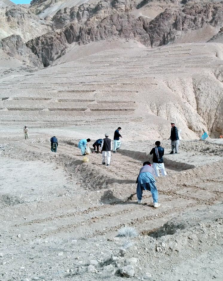
In order to decrease the risk of flash floods, improve pastures and extend cash crop cultivation in upper catchment areas, HELVETAS Swiss Intercooperation has implemented community-based watershed activities such as structural and agronomic measures to control water runoff.
Hing has been identified as a suitable agronomic measure in watershed management in Saighan district. HELVETAS Swiss Intercooperation and the target communities selected hing as a valuable cash crop and a suitable plant for watershed rehabilitation. Today, hing is cultivated on 1,400,000 m2 (140 ha) in nine watersheds and with the participation of 1500 families. The growing period of hing depends on the local climate but tends to be 5-10 years and culminates in the pants’ flowering. During the first five years hing has grey colored leaves. Later a stem appears and grows more than a meter high. The stem is large and yellow and at the end of the main and subordinate stems are yellow flowers. The width of the hing root varies between 7-15 cm and usually goes as deep as 30-40 cm into the soil. Hing plantations have been established with the involvement of the local communities and are managed by the responsible watershed committee. The harvest of hing is organized by the watershed committee and all households have the right to participate and sell hing for income generation. To maintain watershed activities, such as hing cultivation, a safe box has been created for each community-managed watershed. The watershed committee manages the safe box and collects funds for maintenance, community development and emergency projects, according to the watershed management plan which has been developed by the local communities with support of HELVETAS Swiss Intercooperation.
Natural / human environment: Bamyan is a remote province of Afghanistan with a high poverty rate. It has a semi-arid climate with cold winters and hot and dry summers. During winter, temperatures can drop below -22 degrees. Summer temperatures can reach to 34 degrees in the month of July. The average annual rainfall in the area is about 230 mm and some years can be very dry. 90% of the population relies on subsistence agriculture for their livelihoods and off-farm activities are marginal. The growing season in Saighan district is relatively short from April to October and farmers can produce only one crop per year. Farmers with access to irrigation water cultivate cash crops, for example potato and vegetables, in addition to staple (wheat) and fodder crops. Those without access to irrigation water cultivate wheat and fodder crops only. Water scarcity from May to September may result in a lack of high value crops.
2.3 Photos de la Technologie
Galerie Médias
2.5 Pays/ région/ lieux où la Technologie a été appliquée et qui sont couverts par cette évaluation
Pays:
Afghanistan
Région/ Etat/ Province:
Bamyan
Autres spécifications du lieu:
Saighan
Spécifiez la diffusion de la Technologie:
- répartie uniformément sur une zone
Si la Technologie est uniformément répartie sur une zone, précisez la superficie couverte (en km2):
1,4
S'il n'existe pas d'informations exactes sur la superficie, indiquez les limites approximatives de la zone couverte:
- 1-10 km2
2.6 Date de mise en œuvre de la Technologie
Si l'année précise est inconnue, indiquez la date approximative: :
- il y a moins de 10 ans (récemment)
2.7 Introduction de la Technologie
- Re-introduction
Commentaires (type de projet, etc.) :
The technology was introduced since 2012
3. Classification de la Technologie de GDT
3.1 Principal(aux) objectif(s) de la Technologie
- réduire, prévenir, restaurer les terres dégradées
- créer un impact économique positif
3.2 Type(s) actuel(s) d'utilisation des terres, là où la Technologie est appliquée
Les divers types d'utilisation des terres au sein du même unité de terrain: :
Oui
Précisez l'utilisation mixte des terres (cultures/ pâturages/ arbres):
- Agropastoralisme (y compris les systèmes culture-élevage intégrés)

Terres cultivées
- Cultures pérennes (non ligneuses)
Cultures pérennes (non ligneuses) - Précisez les cultures:
- plantes et herbes médicinales/ aromatiques/ pesticides - pérennes

Pâturages
Pâturage extensif:
- Pastoralisme de type semi-nomade
Pâturage intensif/ production fourragère :
- Affouragement en vert/ zéro-pâturage
Commentaires:
Major land use problems (compiler’s opinion): Lack of management in upper catchment area over the last decades resulted in a severe loss of vegetation and in the loss of biodiversity. Uncontrolled grazing of animals during the spring season prevented seed production of domestic plants. Hot temperature in summer burnt the remaining parts of domestic plants. Each year, the soil is washed away by heavy rainfalls creating gulleys which further reduced the vegetation cover.
Major land use problems (land users’ perception): The users of watershed areas cut shrubs for fuel and graze their animals. The lack of alternatives left them to overuse resources in upper catchment areas during war and conflict.
Future (final) land use (after implementation of SLM Technology): Cropland: Cp: Perennial (non-woody) cropping
Number of growing seasons per year: 1
Longest growing period in days: 120, Longest growing period from month to month: March to July
Livestock density: 10-25 LU /km2
3.3 Est-ce que l’utilisation des terres a changé en raison de la mise en œuvre de la Technologie ?
Est-ce que l’utilisation des terres a changé en raison de la mise en œuvre de la Technologie ?
- Oui (Veuillez remplir les questions ci-après au regard de l’utilisation des terres avant la mise en œuvre de la Technologie)
Les divers types d'utilisation des terres au sein du même unité de terrain: :
Non
Pâturages
- Extensive grazing
3.4 Approvisionnement en eau
Approvisionnement en eau des terres sur lesquelles est appliquée la Technologie:
- pluvial
3.5 Groupe de GDT auquel appartient la Technologie
- cultivation of medical plants
3.6 Mesures de GDT constituant la Technologie

pratiques agronomiques
- A1: Couverture végétale/ du sol
Commentaires:
Type of agronomic measures: better crop cover, mixed cropping / intercropping, cover cropping
3.7 Principaux types de dégradation des terres traités par la Technologie

érosion hydrique des sols
- Wt: perte de la couche superficielle des sols (couche arable)/ érosion de surface
Commentaires:
Main causes of degradation: crop management (annual, perennial, tree/shrub) (The upper catchment area have broken to agricultural lands), deforestation / removal of natural vegetation (incl. forest fires) (Domestic shrubs have been cut and have been used for fuel energy), overgrazing (Without management people grazed their animals in spring season and prevented from the plant seed production.), war and conflicts (3 decades internal wars in Afghanistan)
Secondary causes of degradation: droughts (Continiuosly 3 drought years also had a rule for burning plants in upper catchment areas), poverty / wealth (During internal wars, people were not able to go in other provinces and only they had access to agriculture land and livestock for their livelihood)
3.8 Prévention, réduction de la dégradation ou réhabilitation des terres dégradées
Spécifiez l'objectif de la Technologie au regard de la dégradation des terres:
- restaurer/ réhabiliter des terres sévèrement dégradées
4. Spécifications techniques, activités, intrants et coûts de mise en œuvre
4.1 Dessin technique de la Technologie
Spécifications techniques (associées au dessin technique):
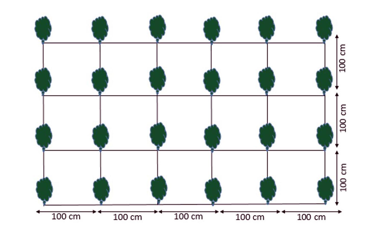
Cultivation plan of Ferula assa-foetida:
Plant to plant distance 100 cm.
Line to line distance 100 cm.
Seed depth 1-1.5 cm with;
3-6 seeds in one spot.
Location: Saighan watersheds. Bamyan
Date: 18/04/2016
Technical knowledge required for field staff / advisors: high
Technical knowledge required for land users: moderate
Main technical functions: control of raindrop splash, improvement of surface structure (crusting, sealing), increase of infiltration, Increase vegetation cover through cash crop
Better crop cover
Material/ species: Ferula assa-foetida
Quantity/ density: 4 plant/m2
Remarks: plant to plant and line to line 100 cm
Mixed cropping / intercropping
Material/ species: Ferula assa-foetida and other domestic plants
Quantity/ density: 1 m2
Remarks: Growing domestic plants between Ferula assa-foetida plants
Cover cropping
Material/ species: Ferula assa-foetida and other plants cover the naked area
Auteur:
Shabir Shahem, HELVETAS Swiss Intercooperation, Afghanistan
4.2 Informations générales sur le calcul des intrants et des coûts
autre/ monnaie nationale (précisez):
Afghani
Indiquez le taux de change des USD en devise locale, le cas échéant (p.ex. 1 USD = 79.9 réal brésilien): 1 USD = :
67,69
Indiquez le coût salarial moyen de la main d'œuvre par jour:
5.17
4.4 Coûts et intrants nécessaires à la mise en place
| Spécifiez les intrants | Unité | Quantité | Coûts par unité | Coût total par intrant | % des coût supporté par les exploitants des terres | |
|---|---|---|---|---|---|---|
| Main d'œuvre | labour | ha | 1,0 | 12,92 | 12,92 | 25,0 |
| Matériel végétal | seeds | ha | 1,0 | 115,0 | 115,0 | 25,0 |
| Coût total de mise en place de la Technologie | 127,92 | |||||
| Coût total de mise en place de la Technologie en dollars américains (USD) | 1,89 | |||||
4.5 Activités d'entretien/ récurrentes
| Activité | Calendrier/ fréquence | |
|---|---|---|
| 1. | Hiring guard for protection of watershed from uncontrolled grazing |
4.6 Coûts et intrants nécessaires aux activités d'entretien/ récurrentes (par an)
Commentaires:
In 2015, the government of Tajikistan did not limit the export of seeds to Afghanistan.
4.7 Facteurs les plus importants affectant les coûts
Décrivez les facteurs les plus importants affectant les coûts :
Good quality seeds are available in Tajikistan. If the government of Tajikistan limits exporting seeds to Afghanistan, seed costs may increase.
5. Environnement naturel et humain
5.1 Climat
Précipitations annuelles
- < 250 mm
- 251-500 mm
- 501-750 mm
- 751-1000 mm
- 1001-1500 mm
- 1501-2000 mm
- 2001-3000 mm
- 3001-4000 mm
- > 4000 mm
Zone agro-climatique
- semi-aride
Thermal climate class: temperate
5.2 Topographie
Pentes moyennes:
- plat (0-2 %)
- faible (3-5%)
- modéré (6-10%)
- onduleux (11-15%)
- vallonné (16-30%)
- raide (31-60%)
- très raide (>60%)
Reliefs:
- plateaux/ plaines
- crêtes
- flancs/ pentes de montagne
- flancs/ pentes de colline
- piémonts/ glacis (bas de pente)
- fonds de vallée/bas-fonds
Zones altitudinales:
- 0-100 m
- 101-500 m
- 501-1000 m
- 1001-1500 m
- 1501-2000 m
- 2001-2500 m
- 2501-3000 m
- 3001-4000 m
- > 4000 m
5.3 Sols
Profondeur moyenne du sol:
- très superficiel (0-20 cm)
- superficiel (21-50 cm)
- modérément profond (51-80 cm)
- profond (81-120 cm)
- très profond (>120 cm)
Texture du sol (de la couche arable):
- moyen (limoneux)
Matière organique de la couche arable:
- faible (<1%)
5.4 Disponibilité et qualité de l'eau
Profondeur estimée de l’eau dans le sol:
5-50 m
Disponibilité de l’eau de surface:
faible/ absente
Qualité de l’eau (non traitée):
uniquement pour usage agricole (irrigation)
5.5 Biodiversité
Diversité des espèces:
- faible
5.6 Caractéristiques des exploitants des terres appliquant la Technologie
Revenus hors exploitation:
- moins de 10% de tous les revenus
Niveau relatif de richesse:
- pauvre
- moyen
Individus ou groupes:
- groupe/ communauté
Genre:
- femmes
- hommes
Indiquez toute autre caractéristique pertinente des exploitants des terres:
Land users applying the Technology are mainly common / average land users
Population density: 10-50 persons/km2
Annual population growth: 0.5% - 1%
10% of the land users are rich.
35% of the land users are average wealthy.
45% of the land users are poor.
Off-farm income specification: The importance of off-farm income is marginal. However, hing cultivation in the watershed presents a viable opportunity to generate income off-farm for the involved communities. Hing can contribute up to >50% of off-farm income.
The watershed belongs to the communities and all households have the same rights.
The income is saved in a communal safe box and is spent for community development and emergency issues.
5.7 Superficie moyenne des terres utilisées par les exploitants des terres appliquant la Technologie
- < 0,5 ha
- 0,5-1 ha
- 1-2 ha
- 2-5 ha
- 5-15 ha
- 15-50 ha
- 50-100 ha
- 100-500 ha
- 500-1 000 ha
- 1 000-10 000 ha
- > 10 000 ha
Cette superficie est-elle considérée comme de petite, moyenne ou grande dimension (en se référant au contexte local)?
- moyenne dimension
5.8 Propriété foncière, droits d’utilisation des terres et de l'eau
Propriété foncière:
- communauté/ village
Droits d’utilisation des terres:
- communautaire (organisé)
Droits d’utilisation de l’eau:
- communautaire (organisé)
5.9 Accès aux services et aux infrastructures
santé:
- pauvre
- modéré
- bonne
éducation:
- pauvre
- modéré
- bonne
assistance technique:
- pauvre
- modéré
- bonne
emploi (par ex. hors exploitation):
- pauvre
- modéré
- bonne
marchés:
- pauvre
- modéré
- bonne
énergie:
- pauvre
- modéré
- bonne
routes et transports:
- pauvre
- modéré
- bonne
eau potable et assainissement:
- pauvre
- modéré
- bonne
services financiers:
- pauvre
- modéré
- bonne
6. Impacts et conclusions
6.1 Impacts sur site que la Technologie a montrés
Impacts socio-économiques
Revenus et coûts
revenus agricoles
Impacts socioculturels
institutions communautaires
Commentaires/ spécifiez:
Watershed committee manage the income of Ferula assa-foetida productions through safe box investment
contribution to human well-being
Commentaires/ spécifiez:
Improve the economic opportunities of the community to generate income
Impacts écologiques
Cycle de l'eau/ ruissellement
ruissellement de surface
Quantité avant la GDT:
5
Quantité après la GDT:
25
Commentaires/ spécifiez:
Vegetation coverage
Sols
humidité du sol
Quantité avant la GDT:
10
Quantité après la GDT:
30
Commentaires/ spécifiez:
When the plants grow more, cover area and infilterate runoff
perte en sol
Quantité avant la GDT:
5
Quantité après la GDT:
50
Commentaires/ spécifiez:
Vegetation coverage
Biodiversité: végétale, animale
espèces bénéfiques
6.2 Impacts hors site que la Technologie a montrés
inondations en aval
Commentaires/ spécifiez:
Vegetation coverage
dommages sur les champs voisins
Commentaires/ spécifiez:
Reduction of flash flood protect lower part resources
dommages sur les infrastructures publiques/ privées
6.3 Exposition et sensibilité de la Technologie aux changements progressifs et aux évènements extrêmes/catastrophes liés au climat (telles que perçues par les exploitants des terres)
Changements climatiques progressifs
Changements climatiques progressifs
| Saison | Augmentation ou diminution | Comment la Technologie fait-elle face à cela? | |
|---|---|---|---|
| températures annuelles | augmente | bien |
Extrêmes climatiques (catastrophes)
Catastrophes météorologiques
| Comment la Technologie fait-elle face à cela? | |
|---|---|
| pluie torrentielle locale | pas bien |
| tempête de vent locale | bien |
Catastrophes hydrologiques
| Comment la Technologie fait-elle face à cela? | |
|---|---|
| inondation générale (rivière) | pas bien |
Autres conséquences liées au climat
Autres conséquences liées au climat
| Comment la Technologie fait-elle face à cela? | |
|---|---|
| réduction de la période de croissance | pas connu |
Commentaires:
Should be cultivated away from flood stream area.
6.4 Analyse coûts-bénéfices
Quels sont les bénéfices comparativement aux coûts de mise en place (du point de vue des exploitants des terres)?
Rentabilité à court terme:
très négative
Rentabilité à long terme:
très positive
Quels sont les bénéfices comparativement aux coûts d'entretien récurrents (du point de vue des exploitants des terres)?
Rentabilité à court terme:
très positive
Rentabilité à long terme:
très positive
Commentaires:
The estabIishment costs are high because hing yields only after five years. However, the investments and maintenance costs are quickly returned once hing can be harvested.
6.5 Adoption de la Technologie
Commentaires:
100% of land user families have adopted the Technology with external material support
750 land user families have adopted the Technology with external material support
In this calculation, the total number of families in 13 villages are considered.
There is no trend towards spontaneous adoption of the Technology
The establishment costs are too high.
6.7 Points forts/ avantages/ possibilités de la Technologie
| Points forts/ avantages/ possibilités du point de vue de l'exploitant des terres |
|---|
| Increase in production of the valuable plants in the upland areas. |
| Protection of the lower lands from the risk of flash floods. |
| Points forts/ avantages/ possibilités du point de vue du compilateur ou d'une autre personne ressource clé |
|---|
| Introduction and increase in valuable cash crop cultivation in unproductive lands. |
| New income opportunity and increase in income of the community members. |
| Reducing flash flood through increasing vegetation coverage |
6.8 Faiblesses/ inconvénients/ risques de la Technologie et moyens de les surmonter
| Faiblesses/ inconvénients/ risques du point de vue de l’exploitant des terres | Comment peuvent-ils être surmontés? |
|---|---|
| The watershed area is common land. | Need active watershed committee members to manage well (good governance). |
| Faiblesses/ inconvénients/ risques du point de vue du compilateur ou d'une autre personne ressource clé | Comment peuvent-ils être surmontés? |
|---|---|
| People lack alternatives and have therefore no stake to protect the upland areas. | Negotiation with herders to reduce the number of their livestock because of introduction of as new alternative source of income. |
| Tangible benefits are only visible after five years. |
7. Références et liens
7.1 Méthodes/ sources d'information
- visites de terrain, enquêtes sur le terrain
- interviews/entretiens avec les exploitants des terres
Quand les données ont-elles été compilées (sur le terrain)?
17/04/2016
Liens et modules
Développer tout Réduire toutLiens
Aucun lien
Modules
Aucun module trouvé