Stone Faced Soil Bund of South Gonder [ប្រទេសអេត្យូពី]
- ការបង្កើត៖
- បច្ចុប្បន្នភាព
- អ្នកចងក្រង៖ Unknown User
- អ្នកកែសម្រួល៖ –
- អ្នកត្រួតពិនិត្យ Fabian Ottiger
Irken (Amharic)
technologies_1062 - ប្រទេសអេត្យូពី
ពិនិត្យមើលគ្រប់ផ្នែក
ពង្រីកមើលទាំងអស់ បង្រួមទាំងអស់1. ព័ត៌មានទូទៅ
1.2 ព័ត៌មានលម្អិតពីបុគ្គលសំខាន់ៗ និងស្ថាប័នដែលចូលរួមក្នុងការវាយតម្លៃ និងចងក្រងឯកសារនៃបច្ចេកទេស
បុគ្គលសំខាន់ម្នាក់ (ច្រើននាក់)
អ្នកជំនាញឯកទេស SLM:
Ato Moges Anbaw
ប្រទេសអេត្យូពី
អ្នកជំនាញឯកទេស SLM:
Ato Chelie Beyene
ប្រទេសអេត្យូពី
1.3 លក្ខខណ្ឌទាក់ទងទៅនឹងការប្រើប្រាស់ទិន្នន័យដែលបានចងក្រងតាមរយៈ វ៉ូខេត
តើពេលណាដែលទិន្នន័យបានចងក្រង (នៅទីវាល)?
18/10/2005
អ្នកចងក្រង និង(បុគ្គលសំខាន់ៗ)យល់ព្រមទទួលយកនូវលក្ខខណ្ឌនានាទាក់ទងទៅនឹងការប្រើប្រាស់ទិន្នន័យដែលបានចងក្រងតាមរយៈវ៉ូខេត:
បាទ/ចា៎
2. ការពណ៌នាពីបច្ចេកទេស SLM
2.1 ការពណ៌នាដោយសង្ខេបពីបច្ចេកទេស
និយមន័យបច្ចេកទេស:
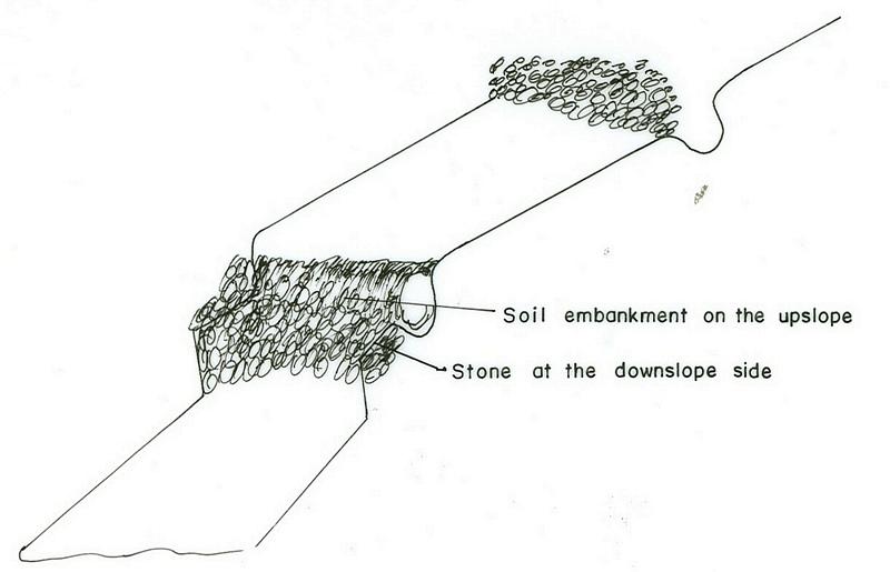
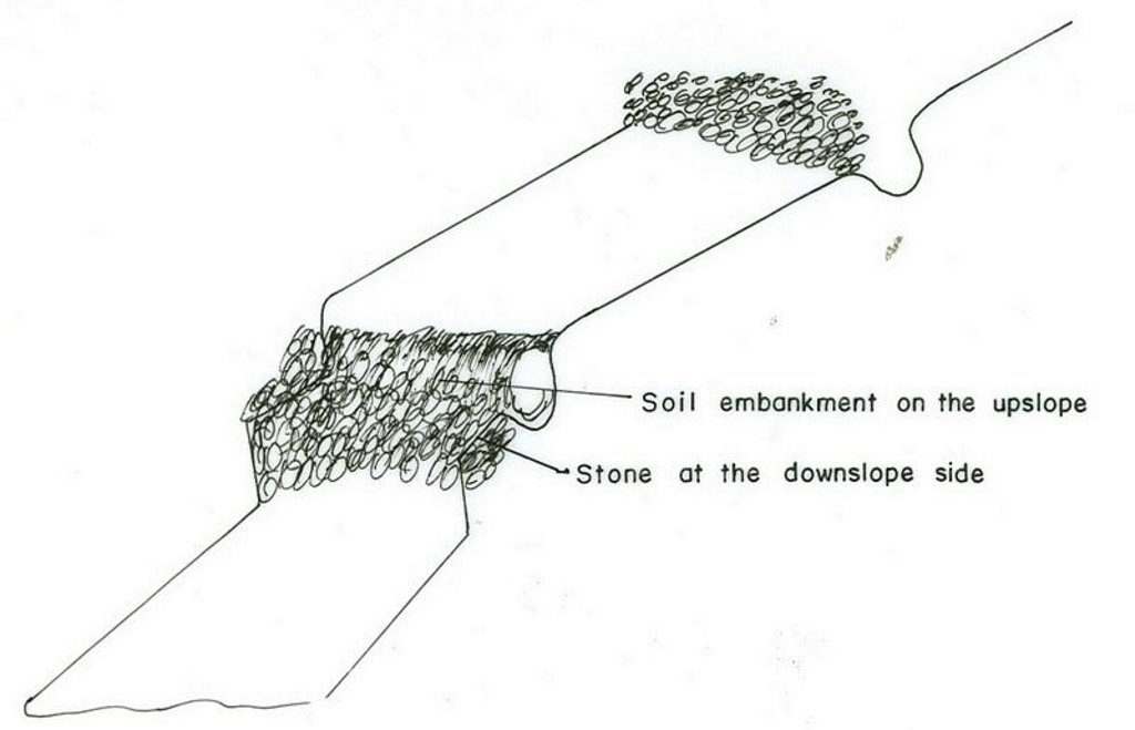
Stone faced soil bund is an embankemt constructed along the contour by the use of stone and soil as a construction material.
2.2 ការពណ៌នាលម្អិតពីបច្ចេកទេស
ការពណ៌នា:
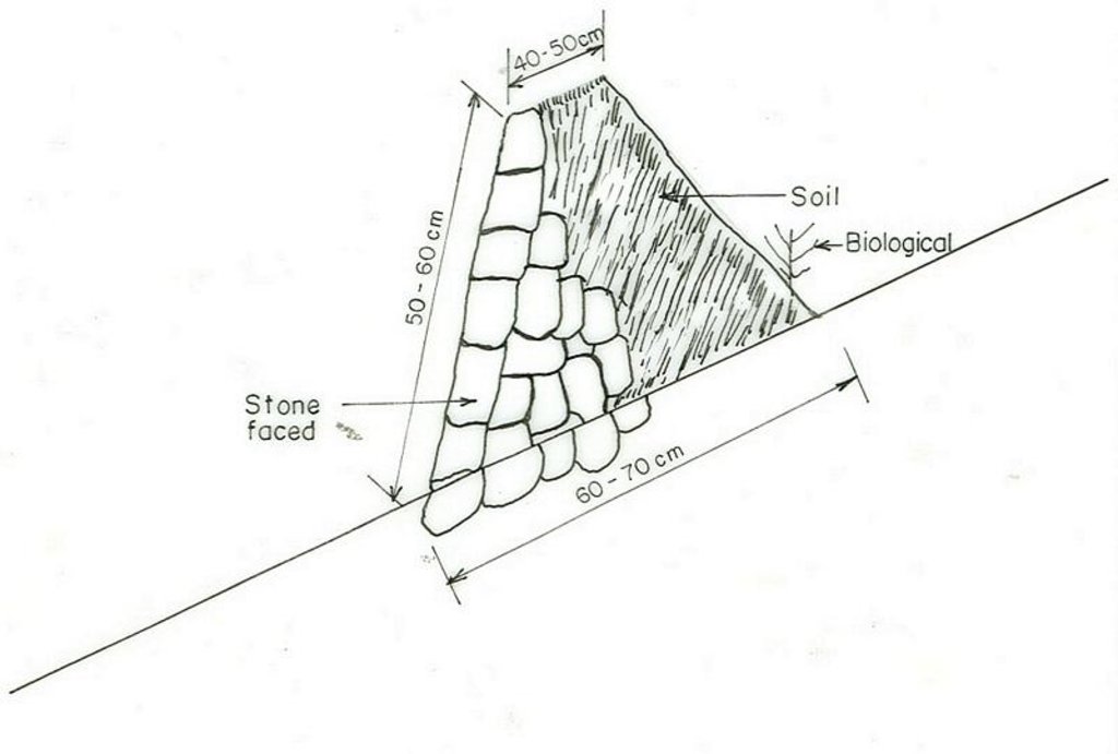
The technology is used in areas where there is no sufficient amount of stone and when the soil depth is shallow. It is established by digging soil and form the embankment. The stone is used at the downslope side for reinforcing the structure. Vegetation is planted on the upper part where there is soil. The purpose is to reduce runoff, decrease slope length, increase infiltration rate and then minimize soil erosion. The structure requires maintenance regularly. Since the stone walls are offten made of small stones, which are not stable. In order to properly stablize the structure livestock should not be allowed to graze on where the structure are placed. Checking for breaks after heavy storms and repair the breaks if any enhances the formation of bench terraces fast.
2.3 រូបភាពនៃបច្ចេកទេស
2.5 ប្រទេស/តំបន់/ទីតាំងកន្លែង ដែលបច្ចេកទេសត្រូវបានអនុវត្ត និងបានគ្រប់ដណ្តប់ដោយការវាយតម្លៃនេះ
ប្រទេស:
ប្រទេសអេត្យូពី
តំបន់/រដ្ឋ/ខេត្ត:
Amhara, South Gonder Zone
បញ្ជាក់បន្ថែមពីលក្ខណៈនៃទីតាំង:
Mukur, Shelo, Gomit
Map
×2.6 កាលបរិច្ឆេទនៃការអនុវត្ត
ប្រសិនបើមិនច្បាស់ឆ្នាំ សូមបញ្ជាក់កាលបរិច្ឆេទដែលប្រហាក់ប្រហែល:
- តិចជាង 10ឆ្នាំមុន (ថ្មី)
2.7 ការណែនាំពីបច្ចេកទេស
សូមបញ្ជាក់តើបច្ចេកទេសត្រូវបានណែនាំឱ្យអនុវត្តដោយរបៀបណា:
- តាមរយៈគម្រោង / អន្តរាគមន៍ពីខាងក្រៅ
មតិយោបល់ (ប្រភេទនៃគម្រោង ។ល។):
from other regions, which started it first.
3. ចំណាត់ថ្នាក់នៃបច្ចេកទេស SLM
3.1 គោលបំណងចម្បង (១ ឬច្រើន) នៃបច្ចេកទេសនេះ
- កាត់បន្ថយ, បង្ការ, ស្តារឡើងវិញនូវការធ្លាក់ចុះគុណភាពដី
3.2 ប្រភេទដីប្រើប្រាស់មួយប្រភេទ (ច្រើនប្រភេទ) ដែលបានអនុវត្តបច្ចេកទេស

ដីដាំដំណាំ
- ដំណាំប្រចាំឆ្នាំ
- ដំណាំរយៈពេលវែង (មិនមែនឈើ)

ដីសម្រាប់ចិញ្ចឹមសត្វ
ដីវាលស្មៅធំៗ:
- ពាក់កណ្តាលពនេចរ
មតិយោបល់:
Major land use problems (compiler’s opinion): overgrazing, land degradation, population pressure
Major land use problems (land users’ perception): low productivity, erosion
Semi-nomadism / pastoralism: free grazing
Grazingland comments: The size of livestock is decreasing because of shortage of land and poor fodder availablity.
Type of cropping system and major crops comments: legumes, teff, wheat, sorghum
3.3 ព័ត៌មានបន្ថែមអំពីអ្នកប្រើប្រាស់ដី
ការផ្គត់ផ្គង់ទឹកនៅកន្លែងអនុវត្តបច្ចេកទេស:
- ទឹកភ្លៀង
មតិយោបល់:
Water supply: Also mixed rainfed-irrigated
ចំនួនសារដែលដាំដំណាំក្នុងមួយឆ្នាំ:
- 1
សូមបញ្ជាក់:
Longest growing period in days: 180 Longest growing period from month to month: Jun - Dec
3.4 ក្រុម SLM ដែលបច្ចេកទេសស្ថិតនៅក្នុង
- វិធានការអនុវត្តកាត់ទទឹងទីជម្រាល
3.5 ការសាយភាយនៃបច្ចេកទេស
មតិយោបល់:
Total area covered by the SLM Technology is 12.51 m2.
hand tools and seedling transportation support is from GTZ and IFSP
3.6 វិធានការ SLM ដែលបញ្ចូលនូវបច្ចេកទេស
3.7 កំណត់ប្រភេទនៃការធ្លាក់ចុះគុណភាពដីសំខាន់ៗដែលបច្ចេកទេសនេះបានដោះស្រាយ

ការហូរច្រោះដីដោយសារទឹក
- Wt: ការបាត់ដីស្រទាប់លើដោយការហូរច្រោះ
- Wg: ការកកើតឡើងនូវកំទេចកំទីដីស្រទាប់ក្រោម

ការធ្លាក់ចុះសារធាតុគីមីក្នុងដី
- Cn: ការថយចុះជីជាតិ និងកាត់បន្ថយបរិមាណសារធាតុសរីរាង្គ (មិនកើតឡើងដោយការហូរច្រោះទេ)
មតិយោបល់:
Main type of degradation addressed: Wt: loss of topsoil / surface erosion
Secondary types of degradation addressed: Wg: gully erosion / gullying, Cn: fertility decline and reduced organic matter content
Main causes of degradation: deforestation / removal of natural vegetation (incl. forest fires), overgrazing, other human induced causes (specify) (agricultural causes), labour availability (lack of labour), land subdivision
Secondary causes of degradation: over-exploitation of vegetation for domestic use, other natural causes (avalanches, volcanic eruptions, mud flows, highly susceptible natural resources, extreme topography, etc.) specify, poverty / wealth (lack of captial), education, access to knowledge and support services (lack of knowledge), lack of enforcement of legislat./authority
3.8 ការពារ កាត់បន្ថយ ឬស្តារឡើងវិញនៃការធ្លាក់ចុះគុណភាពដី
បញ្ជាក់ពីគោលដៅរបស់បច្ចេកទេស ដែលផ្តោតទៅការធ្លាក់ចុះគុណភាពដី:
- ការកាត់បន្ថយការធ្លាក់ចុះគុណភាពដី
មតិយោបល់:
Secondary goals: prevention of land degradation, rehabilitation / reclamation of denuded land
4. បច្ចេកទេសជាក់លាក់ សកម្មភាពអនុវត្ត ធាតុចូល និងថ្លៃដើម
4.1 គំនូសបច្ចេកទេសនៃបច្ចេកទេសនេះ
4.2 លក្ខណៈពិសេសនៃបច្ចេកទេស/ ពណ៌នាពីគំនូរបច្ចេកទេស
Amhara
Technical knowledge required for field staff / advisors: high
Technical knowledge required for land users: moderate
Main technical functions: control of concentrated runoff: retain / trap
Secondary technical functions: control of dispersed runoff: retain / trap, reduction of slope length
Agronomic measure: Planting on bunds
Material/ species: Grasses, sesbenia, vetiver
Manure / compost / residues
Material/ species: from cow dung & green materials
Contour tillage
Remarks: Traditional farm tools
Aligned: -contour
Vegetative material: T : trees / shrubs, G : grass
Number of plants per (ha): 4500
Vertical interval between rows / strips / blocks (m): 1
Spacing between rows / strips / blocks (m): 0.05
Vertical interval within rows / strips / blocks (m): 0.2
Width within rows / strips / blocks (m): 0.7
Trees/ shrubs species: sesbania treclucern
Grass species: vetiver, bana, grass green gold
Bund/ bank: level
Vertical interval between structures (m): 2
Spacing between structures (m): 20
Depth of ditches/pits/dams (m): 0.3-0.4
Width of ditches/pits/dams (m): 0.6-1
Length of ditches/pits/dams (m): 110
Height of bunds/banks/others (m): 0.5-0.6
Width of bunds/banks/others (m): 0.6-1
Length of bunds/banks/others (m): 110
Slope (which determines the spacing indicated above): 15%
If the original slope has changed as a result of the Technology, the slope today is: 5%
Lateral gradient along the structure: 0%
Vegetation is used for stabilisation of structures.
Other type of management: change of management / intensity level - area closuer on small size
4.3 ព័ត៌មានទូទៅដែលពាក់ព័ន្ធនឹងការគណនាធាតុចូល និងថ្លៃដើម
ផ្សេងៗ/ រូបិយប័ណ្ណជាតិ (បញ្ជាក់):
Birr
កំណត់អត្រាប្តូរប្រាក់ពីដុល្លាទៅរូបិយប័ណ្ណតំបន់ (បើទាក់ទង)៖ 1 ដុល្លារ =:
8,6
កំណត់ថ្លៃឈ្នួលជាមធ្យមនៃការជួលកម្លាំងពលកម្មក្នុងមួយថ្ងៃ:
0.80
4.4 សកម្មភាពបង្កើត
| សកម្មភាព | ប្រភេទវិធានការ | ពេលវេលា | |
|---|---|---|---|
| 1. | production of planting materials | សារពើរុក្ខជាតិ | dry season |
| 2. | transporting planting materials | សារពើរុក្ខជាតិ | onset of rain |
| 3. | planting | សារពើរុក្ខជាតិ | rainy season |
| 4. | stone collection | រចនាសម្ព័ន្ធ | dry |
| 5. | digging foundation | រចនាសម្ព័ន្ធ | dry |
| 6. | construction of the bund | រចនាសម្ព័ន្ធ | dry |
| 7. | area clouser | ការគ្រប់គ្រង | the whole year |
4.5 ថ្លៃដើម និងធាតុចូលដែលត្រូវការសម្រាប់ការបង្កើតបច្ចេកទេស
| បញ្ជាក់ពីធាតុចូល | ឯកតា | បរិមាណ | ថ្លៃដើមក្នុងមួយឯកតា | ថ្លៃធាតុចូលសរុប | % នៃថ្លៃដើមដែលចំណាយដោយអ្នកប្រើប្រាស់ដី | |
|---|---|---|---|---|---|---|
| កម្លាំងពលកម្ម | Labour | ha | 1,0 | 183,0 | 183,0 | 100,0 |
| កម្លាំងពលកម្ម | Harvest | ha | 1,0 | 24,0 | 24,0 | 100,0 |
| សម្ភារៈ | Animal traction | ha | 1,0 | 34,0 | 34,0 | 100,0 |
| សម្ភារៈ | Tools | ha | 1,0 | 18,0 | 18,0 | |
| សម្ភារៈដាំដុះ | Seeds | ha | 1,0 | 11,0 | 11,0 | 100,0 |
| សម្ភារៈដាំដុះ | Seedlings | ha | 1,0 | 3,0 | 3,0 | |
| ថ្លៃដើមសរុបក្នុងការបង្កើតបច្ចេកទេស | 273,0 | |||||
មតិយោបល់:
Duration of establishment phase: 12 month(s)
4.6 សកម្មភាពថែទាំ
| សកម្មភាព | ប្រភេទវិធានការ | ពេលវេលា/ ភាពញឹកញាប់ | |
|---|---|---|---|
| 1. | recycling crop residue | ក្សេត្រសាស្ត្រ | dry season / annual |
| 2. | seed bad preparation | ក្សេត្រសាស្ត្រ | dry season / annual |
| 3. | ploughing | ក្សេត្រសាស្ត្រ | dry season / annual |
| 4. | manure/fertilizer | ក្សេត្រសាស្ត្រ | beginning of rains / annual |
| 5. | weeding | ក្សេត្រសាស្ត្រ | end of rain / annual |
| 6. | harvesting | ក្សេត្រសាស្ត្រ | dry season / annual |
| 7. | replanting | សារពើរុក្ខជាតិ | rainy season /as required |
| 8. | pruning/pollarding | សារពើរុក្ខជាតិ | after rain /when there is enough biomass |
| 9. | collecting of stone | រចនាសម្ព័ន្ធ | dry season/as required |
| 10. | repair the broken part | រចនាសម្ព័ន្ធ | dry season/as required |
| 11. | stone facet soil fund | ការគ្រប់គ្រង | dry season (when needed) / |
4.7 កំណត់ថ្លៃដើមសម្រាប់ការថែទាំ/ សកម្មភាពរបស់បច្ចេកទេស (ក្នុងរយៈពេលមួយឆ្នាំ)
| បញ្ជាក់ពីធាតុចូល | ឯកតា | បរិមាណ | ថ្លៃដើមក្នុងមួយឯកតា | ថ្លៃធាតុចូលសរុប | % នៃថ្លៃដើមដែលចំណាយដោយអ្នកប្រើប្រាស់ដី | |
|---|---|---|---|---|---|---|
| កម្លាំងពលកម្ម | Labour | ha | 1,0 | 25,0 | 25,0 | 100,0 |
| ថ្លៃដើមសរុបសម្រាប់ការថែទាំដំណាំតាមបច្ចេកទេស | 25,0 | |||||
មតិយោបល់:
it is for stone faced soil bund construction
4.8 កត្តាសំខាន់បំផុតដែលមានឥទ្ធិពលដល់ការចំណាយ
ពណ៌នាពីកត្តាប៉ះពាល់ចម្បងៗទៅលើថ្លៃដើម:
availability of stone, slope, soil depth
5. លក្ខណៈបរិស្ថានធម្មជាតិ និងមនុស្ស
5.1 អាកាសធាតុ
បរិមាណទឹកភ្លៀងប្រចាំឆ្នាំ
- < 250 មម
- 251-500 មម
- 501-750 មម
- 751-1,000 មម
- 1,001-1,500 មម
- 1,501-2,000 មម
- 2,001-3,000 មម
- 3,001-4,000 មម
- > 4,000 មម
លក្ខណៈពិសេស/ មតិយោបល់លើរដូវភ្លៀង:
950-1400
តំបន់កសិអាកាសធាតុ
- មានភ្លៀងមធ្យម
- មានភ្លៀងតិចតួច
80-85% of the areas is subhumid
15-20% of the area
5.2 សណ្ឋានដី
ជម្រាលជាមធ្យម:
- រាបស្មើ (0-2%)
- ជម្រាលតិចតួច (3-5%)
- មធ្យម (6-10%)
- ជម្រាលខ្ពស់បន្តិច (11-15%)
- ទីទួល (16-30%)
- ទីទួលចោត (31-60%)
- ទីទួលចោតខ្លាំង (>60%)
ទម្រង់ដី:
- ខ្ពង់រាប
- កំពូលភ្នំ
- ជម្រាលភ្នំ
- ជម្រាលទួល
- ជម្រាលជើងភ្នំ
- បាតជ្រលងភ្នំ
តំបន់តាមរយៈកម្ពស់ :
- 0-100 ម
- 101-500 ម
- 501-1,000 ម
- 1,001-1,500 ម
- 1,501-2,000 ម
- 2,001-2,500 ម
- 2,501-3,000 ម
- 3,001-4,000 ម
- > 4,000 ម
មតិយោបល់ និងបញ្ចាក់បន្ថែមអំពីសណ្ឋានដី :
Altitudinal zone: 1501-2000 m a.s.l. (mid altitudes, ranked 1) and 2,001-2,500 m a.s.l. (better rainfall, ranked 2)
Landforms: Footslopes (big and deep gullies exist, ranked 1) and hill slopes (small gullies, ranked 2)
Slopes on average: Rolling (medium soil depth, ranked 1), moderate (deep soil, ranked 2) and hilly (shallow soil, ranked 3)
5.3 ដី
ជម្រៅដីជាមធ្យម:
- រាក់ខ្លាំង (0-20 សម)
- រាក់ (21-50 សម)
- មធ្យម (51-80 សម)
- ជ្រៅ (81-120 សម)
- ជ្រៅខ្លាំង (> 120 សម)
វាយនភាពដី (ស្រទាប់លើ):
- គ្រើម/ មានពន្លឺ (ខ្សាច់)
- មធ្យម (ល្បាយ, ល្បាប់)
សារធាតុសរីរាង្គនៅស្រទាប់ដីខាងលើ:
- មធ្យម (1-3%)
- ទាប (<1%)
បើអាចសូមភ្ជាប់ការពណ៌នាពីដីឱ្យបានច្បាស់ ឬព័ត៌មានដែលអាចទទួលបាន ឧ. ប្រភេទដី, pH ដី/ ជាតិអាស៊ីត, សមត្ថភាពផ្លាស់ប្តូរកាចុង, វត្តមាននីត្រូសែន, ភាពប្រៃ ។ល។:
Soil depth on average: Shallow (gentle slopes, ranked 1) and very shallow (highly steep slopes, ranked 2)
Soil texture: Medium (rolling, ranked 1) and coarse/light (helly, ranked 2)
Soil fertility: Medium (ranked 1) and low (ranked 2)
Topsoil organic matter: Medium (ranked 1, flat terrain) and low (on all land, ranked 2)
Soil drainage/infiltration: Medium
5.6 លក្ខណៈនៃអ្នកប្រើប្រាស់ដីដែលអនុវត្តបច្ចេកទេស
ទីផ្សារនៃប្រព័ន្ធផលិតកម្ម:
- សម្រាប់ហូបក្នុងគ្រួសារ (ផ្គត់ផ្គង់ខ្លួនឯង)
- ពាក់កណ្តាលពាណិជ្ជកម្ម (ផ្គត់ផ្គង់ខ្លួនឯង/ ពាណិជ្ជកម្ម
ចំណូលក្រៅកសិកម្ម:
- តិចជាង 10% នៃចំណូល
កម្រិតជីវភាព:
- មិនល្អ
- មធ្យម
កម្រិតប្រើប្រាស់គ្រឿងយន្ត:
- ប្រើកម្លាំងសត្វ
សូមបញ្ជាក់ពីលក្ខណៈពាក់ព័ន្ធផ្សេងទៀតអំពីអ្នកប្រើប្រាស់ដី:
Population density: 100-200 persons/km2
Annual population growth: 2% - 3%
and own 11% of the land.
and own 72% of the land.
and own 27% of the land.
5.7 ទំហំផ្ទៃដីជាមធ្យមនៃដីផ្ទាល់ខ្លួន ឬជួលគេដែលបានអនុវត្តបច្ចេកទេស
- < 0.5 ហិកតា
- 0.5-1 ហិកតា
- 1-2 ហិកតា
- 2-5 ហិកតា
- 5-15 ហិកតា
- 15-50 ហិកតា
- 50-100 ហិកតា
- 100-500 ហិកតា
- 500-1,000 ហិកតា
- 1,000-10,000 ហិកតា
- > 10,000 ហិកតា
មតិយោបល់:
The size is shrinking every year/more and more since grazing land is converted to cultivated lands
5.8 ភាពជាម្ចាស់ដី កម្មសិទ្ធប្រើប្រាស់ដី និងកម្មសិទ្ធប្រើប្រាស់ទឹក
ភាពជាម្ចាស់ដី:
- រដ្ឋ
- ឯកជន មិនមានកម្មសិទ្ធ
កម្មសិទ្ធិប្រើប្រាស់ដី:
- ឯកជន
6. ផលប៉ះពាល់ និងការសន្និដ្ឋាន
6.1 ផលប៉ះពាល់ក្នុងបរិវេណអនុវត្តបច្ចេកទេសដែលកើតមាន
ផលប៉ះពាល់លើសេដ្ឋកិច្ចសង្គម
ផលិតផល
ផលិតកម្មដំណាំ
មតិយោបល់/ ការបញ្ជាក់:
field crop
ផលិតកម្មចំណីសត្វ
មតិយោបល់/ ការបញ្ជាក់:
legumes & grass
គុណភាពចំណីសត្វ
មតិយោបល់/ ការបញ្ជាក់:
legumes & grass
ផលប៉ះពាល់ទៅលើវប្បធម៌សង្គម
ការកាត់បន្ថយជម្លោះ
ផលប៉ះពាល់ទៅលើអេកូឡូស៊ី
ដី
គម្របដី
មតិយោបល់/ ការបញ្ជាក់:
due to SWC measure
ការបាត់បង់ដី
មតិយោបល់/ ការបញ្ជាក់:
due to constructed stone faced soil bund
6.2 ផលប៉ះពាល់ក្រៅបរិវេណអនុវត្តបច្ចេកទេសដែលកើតមាន
លំហូរទឹកដែលអាចប្រើប្រាស់បាននៅរដូវប្រាំង
ទឹកជំនន់ខ្សែទឹកខាងក្រោម
6.4 ការវិភាគថ្លៃដើម និងអត្ថប្រយោជន៍
តើផលចំណេញ និងថ្លៃដើមត្រូវបានប្រៀបធៀបគ្នាយ៉ាងដូចម្តេច (ទស្សនៈរបស់អ្នកប្រើប្រាស់ដី)?
រយៈពេលខ្លី:
វិជ្ជមាន
រយៈពេលវែង:
វិជ្ជមាន
តើផលចំណេញ និងការថែទាំ/ ជួសជុលត្រូវបានប្រៀបធៀបគ្នាយ៉ាងដូចម្តេច (ទស្សនៈរបស់អ្នកប្រើប្រាស់ដី)?
រយៈពេលខ្លី:
វិជ្ជមាន
រយៈពេលវែង:
វិជ្ជមាន
6.5 ការទទួលយកបច្ចេកទេស
មតិយោបល់:
75% of land user families have adopted the Technology with external material support
4 land user families have adopted the Technology with external material support
Comments on acceptance with external material support: estimates
75% of land user families have adopted the Technology without any external material support
4 land user families have adopted the Technology without any external material support
Comments on spontaneous adoption: estimates
There is a moderate trend towards spontaneous adoption of the Technology
Comments on adoption trend: moderate
6.7 ភាពខ្លាំង/ គុណសម្បត្តិ/ ឱកាសនៃបច្ចេកទេស
| ភាពខ្លាំង/ គុណសម្បត្តិ/ ឱកាសនៅកន្លែងរបស់អ្នកប្រើប្រាស់ដី |
|---|
|
decrease soil erosion How can they be sustained / enhanced? continous maintenance and limit livestock movment |
| increase soil depth |
| increase production |
| ភាពខ្លាំង/ គុណសម្បត្តិ/ ឱកាស ទស្សនៈរបស់បុគ្គលសំខាន់ៗ |
|---|
|
decrease slope length How can they be sustained / enhanced? continuous maintenance |
| increase infiltration |
6.8 ភាពខ្សោយ/ គុណវិបត្តិ/ ហានិភ័យនៃបច្ចេកទេស និងវិធីសាស្ត្រដោះស្រាយ
| ភាពខ្សោយ/ គុណវិបត្តិ/ ហានិភ័យ ទស្សនៈរបស់អ្នកប្រើប្រាស់ដី | តើបច្ចេកទេសទាំងនោះបានដោះស្រាយបញ្ហាដូចម្តេច? |
|---|---|
| loss of land | increase the productivity per unit area of land |
| pest | use of pesticide |
ការតភ្ជាប់ និងម៉ូឌុល
ពង្រីកមើលទាំងអស់ បង្រួមទាំងអស់ការតភ្ជាប់
គ្មានការតភ្ជាប់
ម៉ូឌុល
គ្មានម៉ូឌុល


