
Kitui Sand dams [ប្រទេសកេនយ៉ា]
- ការបង្កើត៖
- បច្ចុប្បន្នភាព
- អ្នកចងក្រង៖ Unknown User
- អ្នកកែសម្រួល៖ –
- អ្នកត្រួតពិនិត្យច្រើនទៀត៖ David Streiff, Alexandra Gavilano
Mung'eeto (KIKAMBA)
technologies_1486 - ប្រទេសកេនយ៉ា
ពិនិត្យមើលគ្រប់ផ្នែក
ពង្រីកមើលទាំងអស់ បង្រួមទាំងអស់1. ព័ត៌មានទូទៅ
1.3 លក្ខខណ្ឌទាក់ទងទៅនឹងការប្រើប្រាស់ទិន្នន័យដែលបានចងក្រងតាមរយៈ វ៉ូខេត
អ្នកចងក្រង និង(បុគ្គលសំខាន់ៗ)យល់ព្រមទទួលយកនូវលក្ខខណ្ឌនានាទាក់ទងទៅនឹងការប្រើប្រាស់ទិន្នន័យដែលបានចងក្រងតាមរយៈវ៉ូខេត:
បាទ/ចា៎
1.5 ការយោងទៅលើកម្រងបញ្ជីសំណួរ (មួយ ឬច្រើន) នៃវិធីសាស្ត្រផ្សព្វផ្សាយ SLM (ដែលបានចងក្រងដោយទស្សនៈពិភពលោកស្តីពីវិធីសាស្ត្រ និងបច្ចេកទេសងអភិរក្ស WOCAT)
SASOL community approach - for sand dams in … [ប្រទេសកេនយ៉ា]
Community based water resource development
- អ្នកចងក្រង៖ Donald B. Thomas
2. ការពណ៌នាពីបច្ចេកទេស SLM
2.1 ការពណ៌នាដោយសង្ខេបពីបច្ចេកទេស
និយមន័យបច្ចេកទេស:
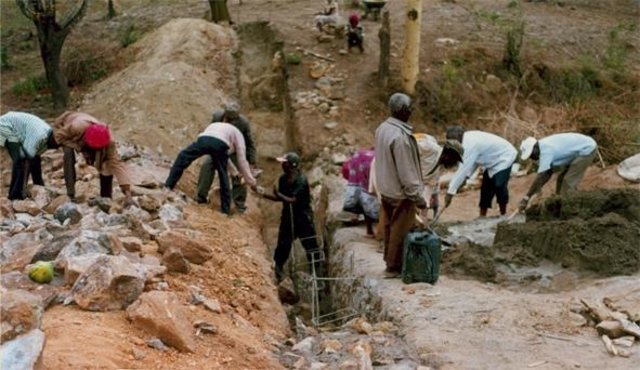
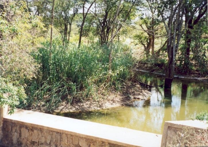
Masonry dam in seasonal watercourse or river that stores water in the sand which accumulates above it.
2.2 ការពណ៌នាលម្អិតពីបច្ចេកទេស
ការពណ៌នា:
The dams are usually constructed where there is a rock bar in the river bed. The dam wall is raised 1.5 - 2.0 M above the level of sand.They fill up quickly with sand in which water is stored. The sand reduces the rate of evaporation and about 30% of the volume can store water for use in the dry season. If the dam is well constructed, maintenance is minimal. The dams are especially useful in semi-arid areas with catchments that provides plenty of coarse sand to fill up the reservoir.
2.3 រូបភាពនៃបច្ចេកទេស
វិចិត្រសាលប្រព័ន្ធផ្សព្វផ្សាយ
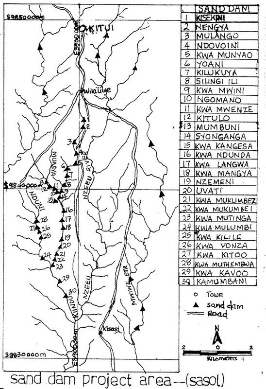

2.5 ប្រទេស/តំបន់/ទីតាំងកន្លែង ដែលបច្ចេកទេសត្រូវបានអនុវត្ត និងបានគ្រប់ដណ្តប់ដោយការវាយតម្លៃនេះ
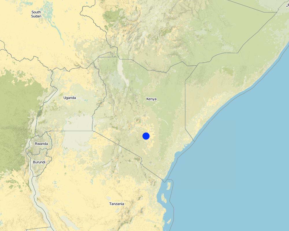
ប្រទេស:
ប្រទេសកេនយ៉ា
តំបន់/រដ្ឋ/ខេត្ត:
Eastern
មតិយោបល់:
Total area covered by the SLM Technology is 200 m2.
The area was selected because of the need for water in the dry season and the density of population to implement the sand dam construction
Map
×2.6 កាលបរិច្ឆេទនៃការអនុវត្ត
ប្រសិនបើមិនច្បាស់ឆ្នាំ សូមបញ្ជាក់កាលបរិច្ឆេទដែលប្រហាក់ប្រហែល:
- តិចជាង 10ឆ្នាំមុន (ថ្មី)
2.7 ការណែនាំពីបច្ចេកទេស
សូមបញ្ជាក់តើបច្ចេកទេសត្រូវបានណែនាំឱ្យអនុវត្តដោយរបៀបណា:
- តាមរយៈគម្រោង / អន្តរាគមន៍ពីខាងក្រៅ
មតិយោបល់ (ប្រភេទនៃគម្រោង ។ល។):
Introduced in semi arid regions of kenya by the colonial government to increase water availabilty during the dry period through construction of masonary barrier across ephemeral rivers.
3. ចំណាត់ថ្នាក់នៃបច្ចេកទេស SLM
3.1 គោលបំណងចម្បង (១ ឬច្រើន) នៃបច្ចេកទេសនេះ
- បន្ស៊ាំទៅនឹងការប្រែប្រួលអាកាសធាតុ/គ្រោះមហន្តរាយ និងផលប៉ះពាល់របស់វា
3.2 ប្រភេទដីប្រើប្រាស់មួយប្រភេទ (ច្រើនប្រភេទ) ដែលបានអនុវត្តបច្ចេកទេស

ផ្លូវទឹក ផ្ទៃទឹក ដីសើម
- ស្រះ ទំនប់
មតិយោបល់:
Major land use problems (compiler’s opinion): Semi-arid conditions with frequent failure of rains and experience water availabilty problems during dry period. High incidence of both on-farm soil erosion.
Major land use problems (land users’ perception): drought , insufficient rains, water scacity.
Number of growing seasons per year: 2
Longest growing period in days: 60 Longest growing period from month to month: Oct - JanSecond longest growing period in days: 58 Second longest growing period from month to month: Mar - May
3.5 ក្រុម SLM ដែលបច្ចេកទេសស្ថិតនៅក្នុង
- ការស្តុកទុកទឹក
3.6 វិធានការ SLM ដែលបញ្ចូលនូវបច្ចេកទេស

វិធានការរចនាស័ម្ពន្ធ
- S5: ទំនប់ ថ្លុក ស្រះ
3.7 កំណត់ប្រភេទនៃការធ្លាក់ចុះគុណភាពដីសំខាន់ៗដែលបច្ចេកទេសនេះបានដោះស្រាយ

ការហូរច្រោះដីដោយសារទឹក
- Wg: ការកកើតឡើងនូវកំទេចកំទីដីស្រទាប់ក្រោម
- Wr: សំណឹកដីច្រាំងទន្លេ
មតិយោបល់:
Main type of degradation addressed: Wr: riverbank erosion
Secondary types of degradation addressed: Wg: gully erosion / gullying
Main causes of degradation: other natural causes (avalanches, volcanic eruptions, mud flows, highly susceptible natural resources, extreme topography, etc.) specify (Semi-arid climate)
Secondary causes of degradation: deforestation / removal of natural vegetation (incl. forest fires), over-exploitation of vegetation for domestic use (reduced infiltration and drying of springs), overgrazing, poverty / wealth (Lack of captial), education, access to knowledge and support services (Lack of knowledge - incidence of water borne dieseases)
4. បច្ចេកទេសជាក់លាក់ សកម្មភាពអនុវត្ត ធាតុចូល និងថ្លៃដើម
4.1 គំនូសបច្ចេកទេសនៃបច្ចេកទេសនេះ
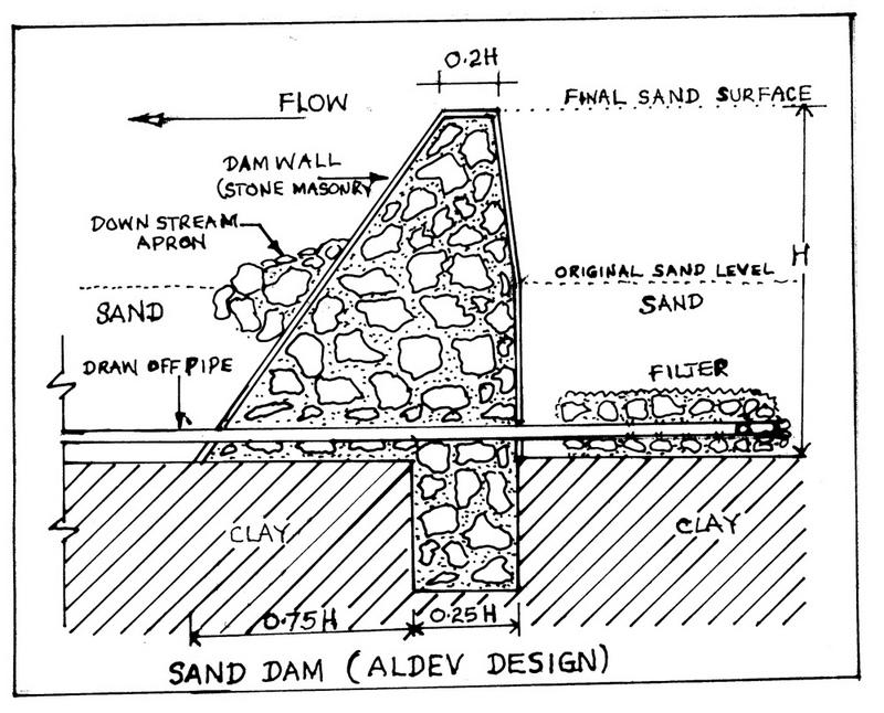
លក្ខណៈពិសេសនៃបច្ចេកទេស (ទាក់ទងនឺងគំនូរបច្ចេកទេស):
Technical knowledge required for field staff / advisors: high
Technical knowledge required for land users: moderate
Main technical functions: water harvesting / increase water supply, sediment retention / trapping, sediment harvesting
Secondary technical functions: increase / maintain water stored in soil
Construction material (concrete): Masonry structure using rocks & stones with some reinforcing bars and wires
Construction material (other): reinforced bars and wires
Lateral gradient along the structure: 5%
4.2 ព័ត៌មានទូទៅដែលពាក់ព័ន្ធនឹងការគណនាធាតុចូល និងថ្លៃដើម
ផ្សេងៗ/ រូបិយប័ណ្ណជាតិ (បញ្ជាក់):
Kenya shillings
បើពាក់ព័ន្ធសូមកំណត់អត្រាប្តូរប្រាក់ពីដុល្លាទៅរូបិយប័ណ្ណតំបន់ (ឧ. 1 ដុល្លារ = 79.9 រៀលនៃរូបិយប័ណ្ណប្រេស៊ីល) ៖ 1 ដុល្លារ =:
78,0
កំណត់ថ្លៃឈ្នួលជាមធ្យមនៃការជួលកម្លាំងពលកម្មក្នុងមួយថ្ងៃ:
2.00
4.3 សកម្មភាពបង្កើត
| សកម្មភាព | រយៈពេល (រដូវកាល) | |
|---|---|---|
| 1. | Digging out riverbed to reach rock bar | dryseason |
| 2. | Laying concrete foundation | dryseason |
| 3. | collection of materials (rocks, sand) | dryseason |
| 4. | construction of dam and wing walls | dryseason |
4.4 ថ្លៃដើម និងធាតុចូលដែលត្រូវការសម្រាប់ការបង្កើតបច្ចេកទេស
មតិយោបល់:
Duration of establishment phase: 24 month(s)
4.5 សកម្មភាពថែទាំ
| សកម្មភាព | ពេលវេលា/ ភាពញឹកញាប់ | |
|---|---|---|
| 1. | inspection of dam for leakages | after the rains/each cropping season |
4.6 កំណត់ថ្លៃដើមសម្រាប់ការថែទាំ/ សកម្មភាពរបស់បច្ចេកទេស (ក្នុងរយៈពេលមួយឆ្នាំ)
មតិយោបល់:
depth of the foundation, valley width.
4.7 កត្តាសំខាន់បំផុតដែលមានឥទ្ធិពលដល់ការចំណាយ
ពណ៌នាពីកត្តាប៉ះពាល់ចម្បងៗទៅលើថ្លៃដើម:
depth of foundation trench to the rock bar, the width of the river valley and the height of the banks.
5. លក្ខណៈបរិស្ថានធម្មជាតិ និងមនុស្ស
5.1 អាកាសធាតុ
បរិមាណទឹកភ្លៀងប្រចាំឆ្នាំ
- < 250 មម
- 251-500 មម
- 501-750 មម
- 751-1,000 មម
- 1,001-1,500 មម
- 1,501-2,000 មម
- 2,001-3,000 មម
- 3,001-4,000 មម
- > 4,000 មម
តំបន់កសិអាកាសធាតុ
- មានភ្លៀងមធ្យម
- មានភ្លៀងតិចតួច
5.2 សណ្ឋានដី
ជម្រាលជាមធ្យម:
- រាបស្មើ (0-2%)
- ជម្រាលតិចតួច (3-5%)
- មធ្យម (6-10%)
- ជម្រាលខ្ពស់បន្តិច (11-15%)
- ទីទួល (16-30%)
- ទីទួលចោត (31-60%)
- ទីទួលចោតខ្លាំង (>60%)
ទម្រង់ដី:
- ខ្ពង់រាប
- កំពូលភ្នំ
- ជម្រាលភ្នំ
- ជម្រាលទួល
- ជម្រាលជើងភ្នំ
- បាតជ្រលងភ្នំ
តំបន់តាមរយៈកម្ពស់ :
- 0-100 ម
- 101-500 ម
- 501-1,000 ម
- 1,001-1,500 ម
- 1,501-2,000 ម
- 2,001-2,500 ម
- 2,501-3,000 ម
- 3,001-4,000 ម
- > 4,000 ម
មតិយោបល់ និងបញ្ចាក់បន្ថែមអំពីសណ្ឋានដី :
Slopes on average: Also gentle
Lanforms: In riverbeads
5.3 ដី
ជម្រៅដីជាមធ្យម:
- រាក់ខ្លាំង (0-20 សម)
- រាក់ (21-50 សម)
- មធ្យម (51-80 សម)
- ជ្រៅ (81-120 សម)
- ជ្រៅខ្លាំង (> 120 សម)
វាយនភាពដី (ស្រទាប់លើ):
- គ្រើម/ មានពន្លឺ (ខ្សាច់)
- មធ្យម (ល្បាយ, ល្បាប់)
សារធាតុសរីរាង្គនៅស្រទាប់ដីខាងលើ:
- ទាប (<1%)
បើអាចសូមភ្ជាប់ការពណ៌នាពីដីឱ្យបានច្បាស់ ឬព័ត៌មានដែលអាចទទួលបាន ឧ. ប្រភេទដី, pH ដី/ ជាតិអាស៊ីត, សមត្ថភាពផ្លាស់ប្តូរកាចុង, វត្តមាននីត្រូសែន, ភាពប្រៃ ។ល។:
Soil depth on average: Most areas have shallow soils with unweathered rocks.
Soil fertility is low
Soil drainage / infiltration is medium and soils are prone to surface sealing
Soil water storage capacity is low - medium
5.6 លក្ខណៈនៃអ្នកប្រើប្រាស់ដីដែលអនុវត្តបច្ចេកទេស
ចំណូលក្រៅកសិកម្ម:
- ច្រើនជាង 50% នៃចំណូល
កម្រិតជីវភាព:
- មិនល្អ
- មធ្យម
សូមបញ្ជាក់ពីលក្ខណៈពាក់ព័ន្ធផ្សេងទៀតអំពីអ្នកប្រើប្រាស់ដី:
Population density: 10-50 persons/km2
Annual population growth: 2% - 3%
1% of the land users are rich and own 5% of the land.
30% of the land users are average wealthy and own 35% of the land.
55% of the land users are poor and own 45% of the land.
14% of the land users are poor and own 15% of the land.
Off-farm income specification: A large proportion of the adult male population is working outside the district
5.8 ភាពជាម្ចាស់ដី កម្មសិទ្ធប្រើប្រាស់ដី និងកម្មសិទ្ធប្រើប្រាស់ទឹក
ភាពជាម្ចាស់ដី:
- ឯកជន មិនមានកម្មសិទ្ធ
- ឯកជន មានកម្មសិទ្ធ
កម្មសិទ្ធិប្រើប្រាស់ដី:
- ឯកជន
6. ផលប៉ះពាល់ និងការសន្និដ្ឋាន
6.4 ការវិភាគថ្លៃដើម និងអត្ថប្រយោជន៍
តើផលចំណេញ និងថ្លៃដើមត្រូវបានប្រៀបធៀបគ្នាយ៉ាងដូចម្តេច (ទស្សនៈរបស់អ្នកប្រើប្រាស់ដី)?
រយៈពេលខ្លី:
វិជ្ជមាន
រយៈពេលវែង:
វិជ្ជមាន
តើផលចំណេញ និងការថែទាំ/ ជួសជុលត្រូវបានប្រៀបធៀបគ្នាយ៉ាងដូចម្តេច (ទស្សនៈរបស់អ្នកប្រើប្រាស់ដី)?
រយៈពេលខ្លី:
វិជ្ជមានខ្លាំង
រយៈពេលវែង:
វិជ្ជមានខ្លាំង
6.5 ការទទួលយកបច្ចេកទេស
- > 50%
បើអាច សូមបញ្ជាក់ពីបរិមាណ (ចំនួនគ្រួសារ និង/ ឬតំបន់គ្របដណ្តប់):
23000 Households in an area of 200 sq km
ក្នុងចំណោមគ្រួសារទាំងអស់ដែលបានអនុវត្តបច្ចេកទេស តើមានប៉ុន្មានគ្រួសារដែលចង់ធ្វើដោយខ្លួនឯង ដោយមិនទទួលបានសម្ភារៈលើកទឹកចិត្ត/ប្រាក់ឧបត្ថម្ភ?:
- 0-10%
មតិយោបល់:
70% of land user families have adopted the Technology.
23000 land user families have adopted the Technology with external material support
Comments on acceptance with external material support: survey results
Comments on spontaneous adoption: estimates
There is a moderate trend towards spontaneous adoption of the Technology
Comments on adoption trend: self help groups have started pooling together their resources for implementation of the technology especially in areas where there has never been an NGO or such a project.
7. ឯកសារយោង និងវេបសាយ
7.1 វិធីសាស្ត្រ/ ប្រភពនៃព័ត៌មាន
7.2 ឯកសារយោងដែលបានចេញផ្សាយ
ចំណងជើង អ្នកនិពន្ធ ឆ្នាំ ISBN:
"Where there is no water" SASOL and Maji na Ufanisi 1999
មានប្រភពមកពីណា? ថ្លៃដើមប៉ុន្មាន?
Maji na Ufanisi Nairobi or SASOL Kitui
ការតភ្ជាប់ និងម៉ូឌុល
ពង្រីកមើលទាំងអស់ បង្រួមទាំងអស់ការតភ្ជាប់
SASOL community approach - for sand dams in … [ប្រទេសកេនយ៉ា]
Community based water resource development
- អ្នកចងក្រង៖ Donald B. Thomas
ម៉ូឌុល
គ្មានម៉ូឌុល