Contour trenches and contour strips [ប្រទេសអ៊ូសបេគីស្ថាន]
- ការបង្កើត៖
- បច្ចុប្បន្នភាព
- អ្នកចងក្រង៖ Joren Verbist
- អ្នកកែសម្រួល៖ –
- អ្នកត្រួតពិនិត្យច្រើនទៀត៖ William Critchley, Rima Mekdaschi Studer
technologies_7557 - ប្រទេសអ៊ូសបេគីស្ថាន
ពិនិត្យមើលគ្រប់ផ្នែក
ពង្រីកមើលទាំងអស់ បង្រួមទាំងអស់1. ព័ត៌មានទូទៅ
1.2 ព័ត៌មានលម្អិតពីបុគ្គលសំខាន់ៗ និងស្ថាប័នដែលចូលរួមក្នុងការវាយតម្លៃ និងចងក្រងឯកសារនៃបច្ចេកទេស
Senior Scientist Sustainable Land Management:
Akramkhanov Akmal
International Center of Agriculture Research in the Dry Areas (ICARDA)
ប្រទេសអ៊ូសបេគីស្ថាន
Crop Specialist:
Fayzullayev Abdulla
International Center of Agriculture Research in the Dry Areas (ICARDA)
ប្រទេសអ៊ូសបេគីស្ថាន
Water Harvesting Expert:
Muddaber Mohammad Ali
International Center of Agriculture Research in the Dry Areas (ICARDA)
ប្រទេសហ្ស៊កដានី
Water Harvesting Expert:
Jafar Alwidyan
International Center of Agriculture Research in the Dry Areas (ICARDA)
ប្រទេសហ្ស៊កដានី
ឈ្មោះគម្រោងដែលបានចងក្រងឯកសារ/ វាយតម្លៃលើបច្ចេកទេស (បើទាក់ទង)
ICARDA Institutional Knowledge Management Initiative1.3 លក្ខខណ្ឌទាក់ទងទៅនឹងការប្រើប្រាស់ទិន្នន័យដែលបានចងក្រងតាមរយៈ វ៉ូខេត
អ្នកចងក្រង និង(បុគ្គលសំខាន់ៗ)យល់ព្រមទទួលយកនូវលក្ខខណ្ឌនានាទាក់ទងទៅនឹងការប្រើប្រាស់ទិន្នន័យដែលបានចងក្រងតាមរយៈវ៉ូខេត:
បាទ/ចា៎
1.4 សេចក្តីប្រកាសស្តីពីចីរភាពនៃការពណ៌នាពីបច្ចេកទេស
តើបច្ចេកទេសដែលបានពណ៌នានេះមានបញ្ហាដែលផ្តោតលើការធ្លាក់ចុះគុណភាពដី, បើដូច្នេះវាមិនអាចត្រូវបានប្រកាសថាជាបច្ចេកទេសនៃការគ្រប់គ្រងប្រកបដោយចីរភាពទេ?
ទេ
2. ការពណ៌នាពីបច្ចេកទេស SLM
2.1 ការពណ៌នាដោយសង្ខេបពីបច្ចេកទេស
និយមន័យបច្ចេកទេស:
Contour trenches for the cultivation of almond trees, and contour strips for cereals are types of rainwater harvesting structures. They are designed to capture runoff, reduce erosion, and enhance soil moisture—thereby improving land productivity and supporting climate-resilient agriculture in lowland dry areas.
2.2 ការពណ៌នាលម្អិតពីបច្ចេកទេស
ការពណ៌នា:
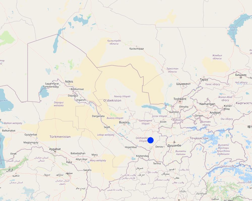
Qashqadaryo Province in southern Uzbekistan experiences a hot, dry summer and a mild winter. Combined with unsustainable land management practices, climatic stresses have exacerbated land degradation and made local livelihoods increasingly vulnerable.
As part of the Food Systems, Land Use and Restoration (FOLUR) project, the International Center for Agricultural Research in the Dry Areas (ICARDA) designed and tested rainwater harvesting (RWH) structures to combat land degradation and enhance rural livelihoods. These RWH structures support vegetation growth, reduce surface runoff, prevent erosion, and restore soil health—thereby reversing degradation and improving agricultural productivity.
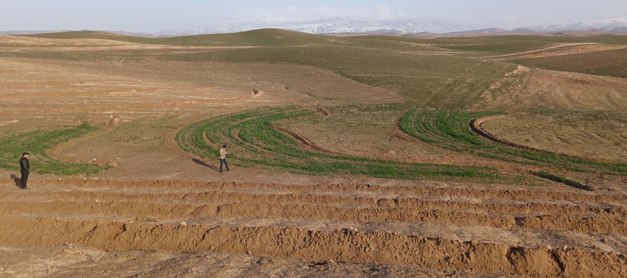
Based on slope gradients and hydrological characteristics, two RWH techniques were selected: modified contour trenches for the slightly sloping upper areas, and modified contour strips for the flatter zones.
In the upper portion of the site, which spans 1.54 hectares, modified contour trenches were implemented for perennial tree crops. Design calculations suggested a spacing of 8 metres between trenches, and 7 metres between almond trees along each trench.
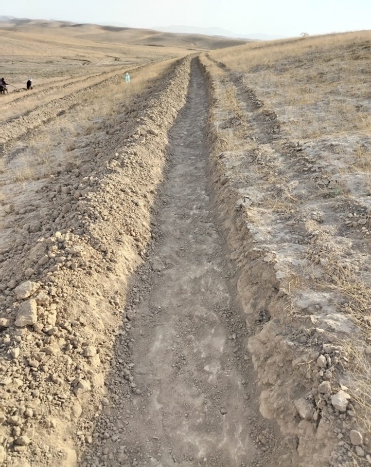
Implementation began with the marking of contour lines using a laser level: two labourers worked for two days. Then a tractor fitted with a three-mouldboard plough dug the trenches. While the tractor generally performed well, work had to be completed manually at sharp bends and gully crossings. Eight labourers then spent two days shaping and stabilizing the trenches. In total, approximately 1,300 metres of trench lines were created.
Costs were relatively modest. The tractor, hired from a farmer, cost $150 per day. Manual labour amounted to 24 person-days at $10 per day. 100 almond trees were planted, and 85 tamarix trees were added as a protective windbreak.
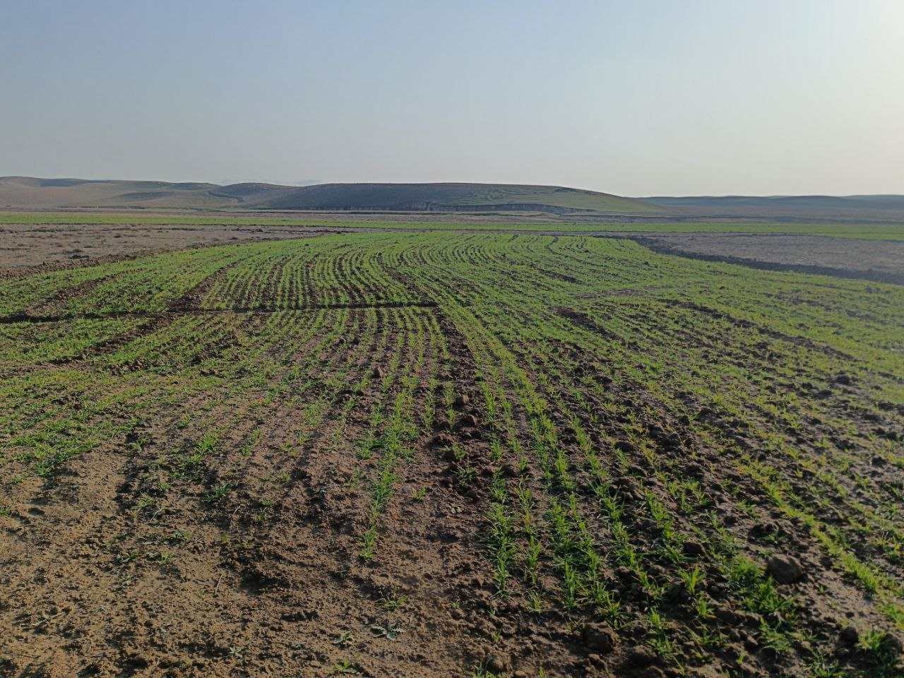
In the lower, flatter part of the site—about 1.68 hectares—standard contour strips were unsuitable due to the very low slope, which would not generate enough runoff. Instead, a modified version was implemented. Low ridges along contour at a vertical interval of 30 cm, allowed rainwater to pool and infiltrate. The same tractor was used with a single mouldboard plough to form nine contour ridges, shaped by two passes.
Afterwards, ten local women labourers finalized the ridges manually. The total length of the contour strips reached 500 metres, and the ratio of catchment to cultivated area varied from 5:1 in the upper sections to 1:1 in the lower zones, based on expected runoff.
The cost of this phase included one day of tractor use and 15 person-days of labour, totalling approximately $300. This site is intended for rainfed cultivation, and will follow a crop rotation system including barley, legumes and fallow periods. Over time, farmers are encouraged to adopt no-till practices to improve soil health.
Following implementation, light rainfall provided a test of the structures. Both the contour trenches and strips performed as intended, with no damage observed.
The interventions demonstrate how a tailored combination of RWH structures and cropping systems can rehabilitate degraded land. Local involvement helped to build community ownership. The result is a more productive and climate-resilient landscape that offers long-term benefits for soil conservation and rural livelihoods.
2.3 រូបភាពនៃបច្ចេកទេស
វិចិត្រសាលប្រព័ន្ធផ្សព្វផ្សាយ
2.5 ប្រទេស/តំបន់/ទីតាំងកន្លែង ដែលបច្ចេកទេសត្រូវបានអនុវត្ត និងបានគ្រប់ដណ្តប់ដោយការវាយតម្លៃនេះ
ប្រទេស:
ប្រទេសអ៊ូសបេគីស្ថាន
បញ្ជាក់បន្ថែមពីលក្ខណៈនៃទីតាំង:
8°43'14.26"N, 66°41'51.87"E
បញ្ជាក់ពីការសាយភាយនៃបច្ចេកទេស:
- ត្រូវបានផ្សព្វផ្សាយត្រឹមតំបន់មួយ
ប្រសិនបើមិនច្បាស់ពីទំហំផ្ទៃដី សូមធ្វើការប៉ាន់ប្រម៉ាណ:
- < 0.1 គម2 (10 ហិកតា)
តើបច្ចេកទេស (មួយ ឬច្រើន) ទាំងនោះស្ថិតនៅក្នុងតំបន់ការពារជាអចិន្ត្រៃយ៍ណាមួយដែរឬទេ?
ទេ
Map
×2.6 កាលបរិច្ឆេទនៃការអនុវត្ត
បង្ហាញឆ្នាំនៃការចុះអនុវត្ត:
2024
2.7 ការណែនាំពីបច្ចេកទេស
សូមបញ្ជាក់តើបច្ចេកទេសត្រូវបានណែនាំឱ្យអនុវត្តដោយរបៀបណា:
- តាមរយៈគម្រោង / អន្តរាគមន៍ពីខាងក្រៅ
3. ចំណាត់ថ្នាក់នៃបច្ចេកទេស SLM
3.1 គោលបំណងចម្បង (១ ឬច្រើន) នៃបច្ចេកទេសនេះ
- ធ្វើឱ្យប្រសើរឡើងនូវផលិតកម្ម
- កាត់បន្ថយ, បង្ការ, ស្តារឡើងវិញនូវការធ្លាក់ចុះគុណភាពដី
- បន្ស៊ាំទៅនឹងការប្រែប្រួលអាកាសធាតុ/គ្រោះមហន្តរាយ និងផលប៉ះពាល់របស់វា
- បង្កើតផលប្រយោជន៍សេដ្ឋកិច្ច
- បង្កើតផលប្រយោជន៍សង្គម
3.2 ប្រភេទដីប្រើប្រាស់មួយប្រភេទ (ច្រើនប្រភេទ) ដែលបានអនុវត្តបច្ចេកទេស
ដីប្រើប្រាស់ចម្រុះនៅលើដីតែមួយ:
ទេ

ដីដាំដំណាំ
- ដំណាំប្រចាំឆ្នាំ
- ដំណាំរយៈពេលវែង (មិនមែនឈើ)
ដំណាំប្រចាំឆ្នាំ - បញ្ជាក់ប្រភេទដំណាំ:
- ធញ្ញជាតិ - ស្រូវ
- Nuts/ fruits including almonds
ចំនួនសារដែលដាំដំណាំក្នុងមួយឆ្នាំ:
- 1
តើជាការអនុវត្តន៍ដំណាំចន្លោះ?
ទេ
តើជាការអនុវត្តន៍ដំណាំវិលជុំ?
បាទ/ចា៎
បើបាទ/ច៎ា សូមបញ្ជាក់:
Barley, legumes etc
មតិយោបល់:
Note fruits/ nuts on one part of the land and cereals/ legumes/ fodder on another section (see 2.2)
3.3 បន្ទាប់ពីអនុវត្តបច្ចេកទេស តើដីប្រើប្រាស់មានការប្រែប្រួលដែររឺទេ?
បន្ទាប់ពីអនុវត្តបច្ចេកទេស តើដីប្រើប្រាស់មានការប្រែប្រួលដែររឺទេ?
- បាទ/ច៎ា (សូមបំពេញសំណួរខាងក្រោមពីស្ថានភាពដីប្រើប្រាស់មុនពេលអនុវត្តបច្ចេកទេស)
ដីប្រើប្រាស់ចម្រុះនៅលើដីតែមួយ:
ទេ

ដីសម្រាប់ចិញ្ចឹមសត្វ
វាលស្មៅធំៗ:
- ពាក់កណ្តាលពនេចរ
- Mixed
3.4 ការផ្គត់ផ្គង់ទឹក
ការផ្គត់ផ្គង់ទឹកនៅកន្លែងអនុវត្តបច្ចេកទេស:
- ទឹកភ្លៀង
3.5 ក្រុម SLM ដែលបច្ចេកទេសស្ថិតនៅក្នុង
- ធ្វើឱ្យប្រសើរឡើងគម្របដី/ ដំណាំគម្របដី
- វិធានការអនុវត្តកាត់ទទឹងទីជម្រាល
- ការស្តុកទុកទឹក
3.6 វិធានការ SLM ដែលបញ្ចូលនូវបច្ចេកទេស

វិធានការក្សេត្រសាស្ត្រ
- A1: ដំណាំ/គម្របដី
- A3: ការរក្សាស្រទាប់ដីខាងលើ
- A4: ការរក្សាស្រទាប់ដីខាងក្នុង

វិធានការរុក្ខជាតិ
- V1: ឈើធំៗ និងដើមឈើតូចៗ

វិធានការរចនាស័ម្ពន្ធ
- S1: ការធ្វើដីថ្នាក់ៗតាមជម្រាលភ្នំ
- S2: ភ្លឺ ច្រាំង
- S3: កម្ពស់ភ្លឺ ប្រឡាយ ផ្លូវទឹក
- S7: ការប្រមូលទឹកស្តុកទុក/ផ្គត់ផ្គង់ទឹក/ សម្ភារៈស្រោចស្រព

វិធានការគ្រប់គ្រង
- M1: ការផ្លាស់ប្តូរប្រភេទដីប្រើប្រាស់
3.7 កំណត់ប្រភេទនៃការធ្លាក់ចុះគុណភាពដីសំខាន់ៗដែលបច្ចេកទេសនេះបានដោះស្រាយ

ការហូរច្រោះដីដោយសារទឹក
- Wt: ការបាត់ដីស្រទាប់លើដោយការហូរច្រោះ
- Wg: ការកកើតឡើងនូវកំទេចកំទីដីស្រទាប់ក្រោម
- Wo: ផលប៉ះពាល់នៃការធ្លាក់ចុះគុណភាពកន្លែងឆ្ងាយ

ការបាត់ដីដោយសារខ្យល់
- Et: ការបាត់បង់ដីស្រទាប់លើ
- Ed: អតិផរណា និង ការទម្លាក់
- Eo: ផលប៉ះពាល់នៃការធ្លាក់ចុះគុណភាព

ការបាត់បង់រូបសាស្ត្រនៃដី
- Pc: ការហាប់ណែន
- Pk: ការបិទរន្ធដី

ការធ្លាក់ចុះជីវសាស្ត្រនៃដី
- Bc: ការថយចុះនូវគម្របរុក្ខជាតិ
- Bq: ការថយចុះនូវជីវម៉ាស/ បរិមាណ
- Bl: ការបាត់បង់មីក្រូ និងម៉ាក្រូសរីរាង្គរបស់ដី
3.8 ការពារ កាត់បន្ថយ ឬស្តារឡើងវិញនៃការធ្លាក់ចុះគុណភាពដី
បញ្ជាក់ពីគោលដៅរបស់បច្ចេកទេស ដែលផ្តោតទៅការធ្លាក់ចុះគុណភាពដី:
- ការកាត់បន្ថយការធ្លាក់ចុះគុណភាពដី
- ការជួសជុល/ ស្តារឡើងវិញនៃឱនភាពដីធ្ងន់ធ្ងរ
4. បច្ចេកទេសជាក់លាក់ សកម្មភាពអនុវត្ត ធាតុចូល និងថ្លៃដើម
4.1 គំនូសបច្ចេកទេសនៃបច្ចេកទេសនេះ
លក្ខណៈពិសេសនៃបច្ចេកទេស (ទាក់ទងនឺងគំនូរបច្ចេកទេស):
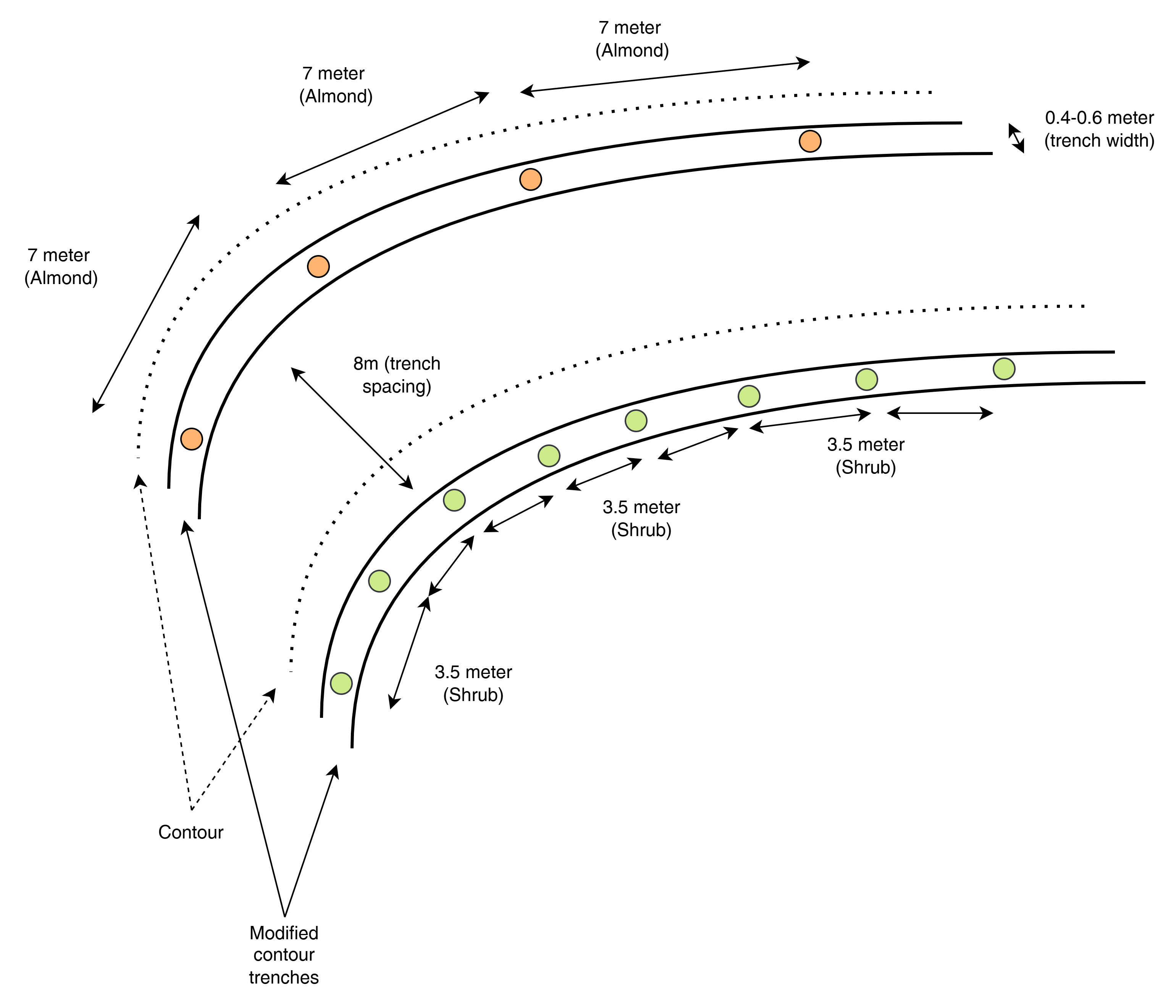
This top-view diagram shows the layout of modified contour trenches along contour lines, spaced 8 meters apart vertically. Each trench supports either:
Almond trees, spaced 7 meters apart, or
Shrubs, spaced 3.5 meters apart.
Each trench is aligned to follow the natural contour of the land to intercept runoff and enhance infiltration. Shrubs and trees are planted separately in designated trenches, not mixed.
ឈ្មោះអ្នកនិពន្ធ:
ICARDA
កាលបរិច្ឆេទ:
2025
លក្ខណៈពិសេសនៃបច្ចេកទេស (ទាក់ទងនឺងគំនូរបច្ចេកទេស):
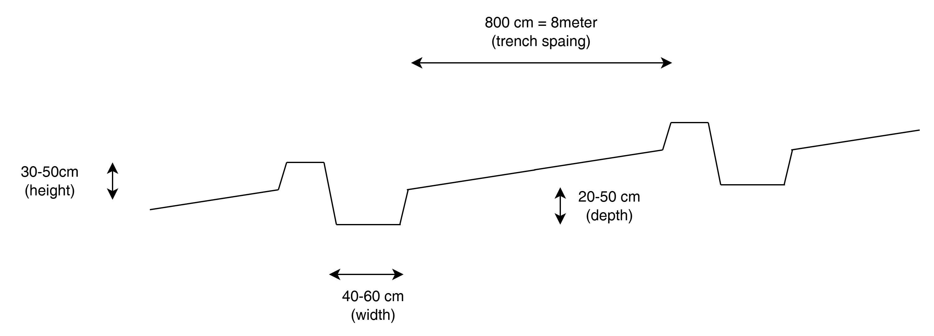
This cross-sectional profile illustrates the physical dimensions of a modified contour trench:
Width: 40–60 cm
Depth: 20–50 cm
Bund height (upslope side): 30–50 cm
Trench spacing: 8 meters
These dimensions are designed to retain and slow down surface runoff on slopes of 10–20%, enhancing water infiltration for tree or shrub growth.
ឈ្មោះអ្នកនិពន្ធ:
ICARDA
កាលបរិច្ឆេទ:
2025
លក្ខណៈពិសេសនៃបច្ចេកទេស (ទាក់ទងនឺងគំនូរបច្ចេកទេស):
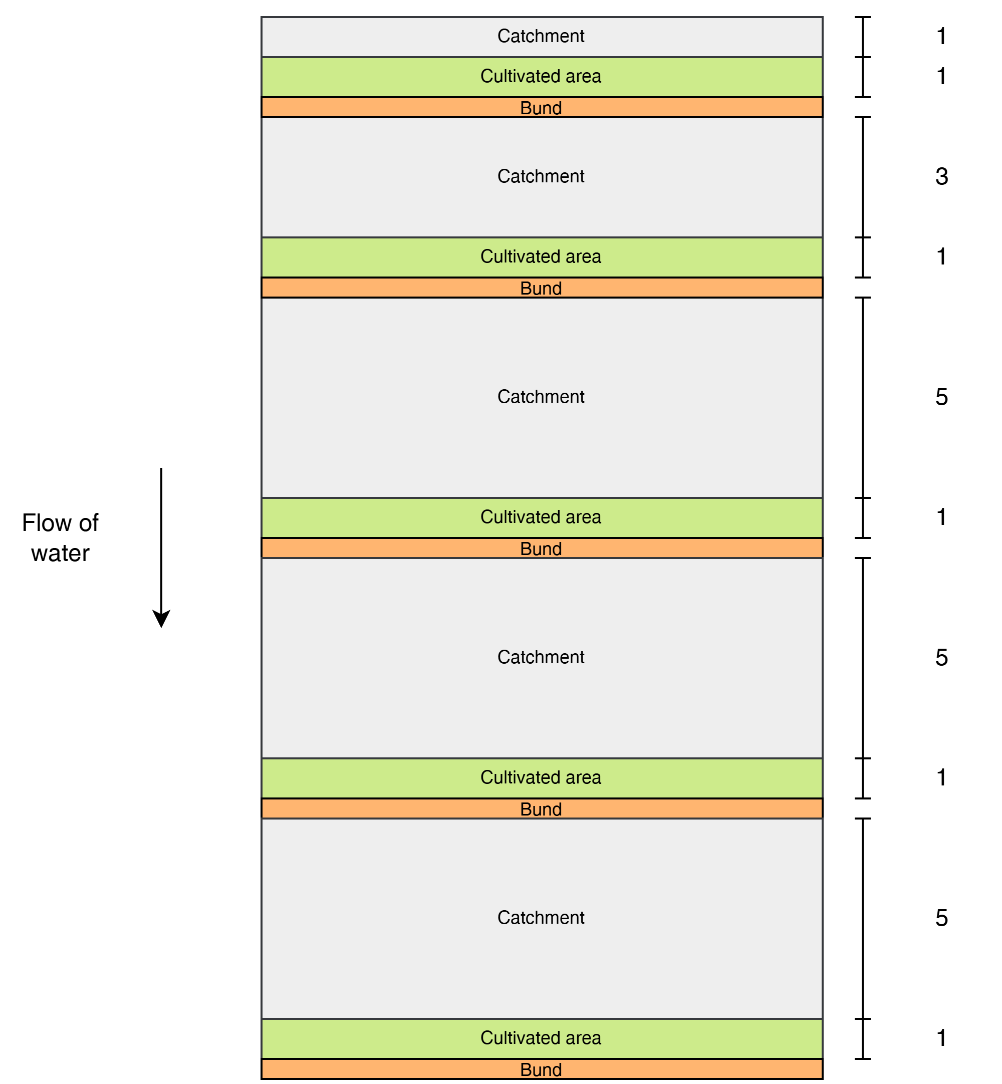
This diagram shows the layout of modified contour strips designed to enhance rainwater harvesting and crop productivity on sloped land. Each unit consists of a cultivated strip supported by a bund, located just downslope of a catchment area that concentrates surface runoff toward the crops.
Water flows downslope through the system.
The catchment-to-cultivated area ratio increases downslope to account for the growing volume and force of accumulated runoff, as well as differences in slope and infiltration capacity:
1:1 in the upper strips, where the steeper slope generates stronger runoff, and only limited water is desired to avoid erosion or damage.
3:1 in the middle strips, where moderate runoff accumulates.
5:1 in the lower strips, where the gentler slope allows more infiltration and where the lower kinetic energy of the runoff poses less risk to the structures.
ឈ្មោះអ្នកនិពន្ធ:
ICARDA
កាលបរិច្ឆេទ:
2025
លក្ខណៈពិសេសនៃបច្ចេកទេស (ទាក់ទងនឺងគំនូរបច្ចេកទេស):
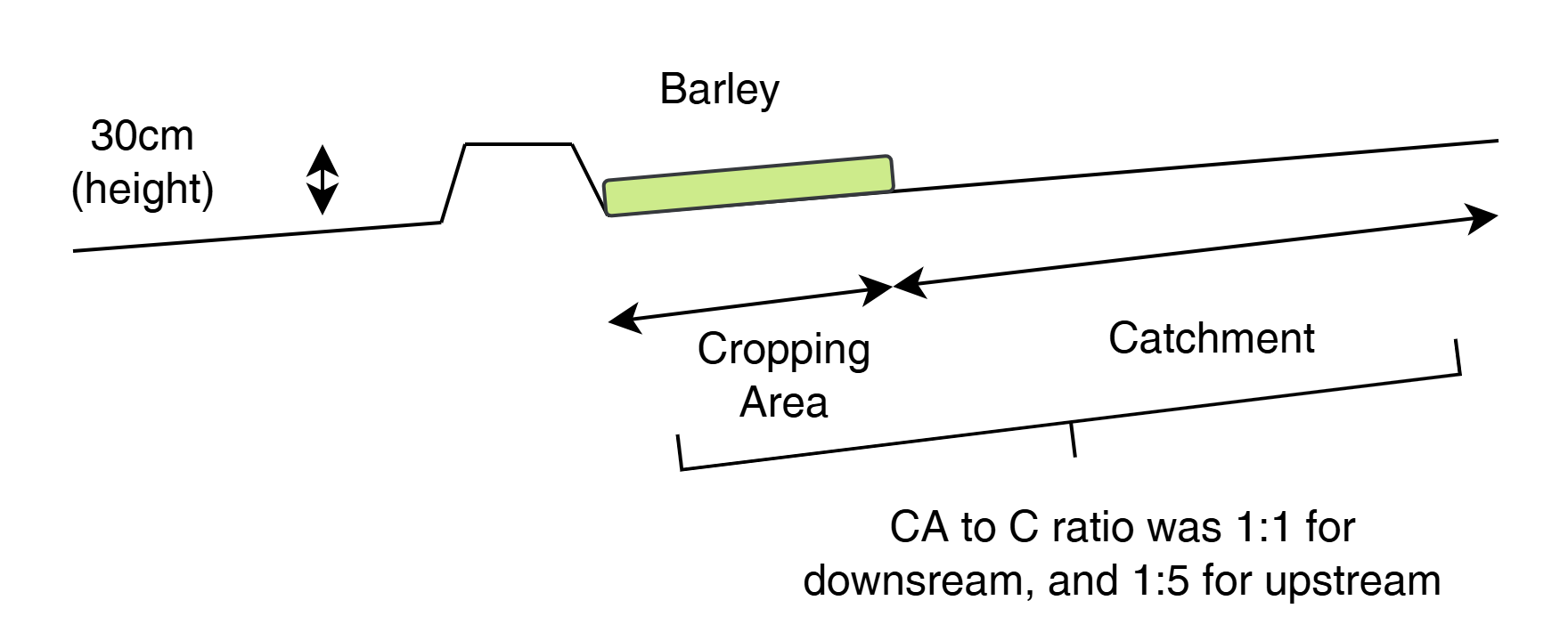
This cross-sectional view illustrates a modified contour strip:
A 30 cm high earth bund holds runoff upslope.
The cropping area (e.g., barley) is placed directly upstream (behind) the bund.
A catchment area lies upslope, sloped to direct water into the cultivated zone.
The catchment-to-cultivated ratio ranges from 5:1 (upper strips) to 1:1 (lower strips) depending on expected runoff volume, ensuring efficient water use and soil conservation.
ឈ្មោះអ្នកនិពន្ធ:
ICARDA
កាលបរិច្ឆេទ:
2025
4.2 ព័ត៌មានទូទៅដែលពាក់ព័ន្ធនឹងការគណនាធាតុចូល និងថ្លៃដើម
កំណត់របៀបនៃការគណនាថ្លៃដើម និងធាតុចូល:
- ក្នុងតំបន់អនុវត្តបច្ចេកទេស
កំណត់ទំហំ និងឯកត្តាផ្ទៃដី:
3 ha (with half: half of each RWH technology)
កំណត់រូបិយប័ណ្ណសម្រាប់ថ្លៃដើម:
- ដុល្លារ
កំណត់ថ្លៃឈ្នួលជាមធ្យមនៃការជួលកម្លាំងពលកម្មក្នុងមួយថ្ងៃ:
10
4.3 សកម្មភាពបង្កើត
| សកម្មភាព | រយៈពេល (រដូវកាល) | |
|---|---|---|
| 1. | Contour marking | 22–23 September |
| 2. | Tractor ploughing | 24–25 September |
| 3. | Manual shaping/finishing | 25–26 September |
| 4. | Tree/shrub planting | 26–27 September |
4.4 ថ្លៃដើម និងធាតុចូលដែលត្រូវការសម្រាប់ការបង្កើតបច្ចេកទេស
| បញ្ជាក់ពីធាតុចូល | ឯកតា | បរិមាណ | ថ្លៃដើមក្នុងមួយឯកតា | ថ្លៃធាតុចូលសរុប | % នៃថ្លៃដើមដែលចំណាយដោយអ្នកប្រើប្រាស់ដី | |
|---|---|---|---|---|---|---|
| កម្លាំងពលកម្ម | Contour trench construction | Person-days | 24,0 | |||
| កម្លាំងពលកម្ម | Bunds for contour strips | Person-days | 15,0 | |||
| កម្លាំងពលកម្ម | Marking contours | Person-days | 4,0 | |||
| សម្ភារៈ | Ploughing (contour trenches) | Machine-days | 3,0 | |||
| សម្ភារៈ | Ploughing (contour strips) | Machine-days | 2,0 | |||
| សម្ភារៈដាំដុះ | Almond seedlings | 100,0 | ||||
| សម្ភារៈដាំដុះ | Shrubs | 85,0 | ||||
| ជី និងសារធាតុពុល | Manure | kg | 600,0 | |||
| ផ្សេងៗ | Lumpsum contour strips | 1,0 | 1000,0 | 1000,0 | ||
| ផ្សេងៗ | Lumpsum contour trenches | 1,0 | 1000,0 | 1000,0 | ||
| ថ្លៃដើមសរុបក្នុងការបង្កើតបច្ចេកទេស | 2000,0 | |||||
| ថ្លៃដើមសរុបក្នុងការបង្កើតបច្ចេកទេសគិតជាដុល្លារ | 2000,0 | |||||
ប្រសិនបើមិនអាចបំបែកតម្លៃដើមក្នុងតារាងខាងក្រោមទេ សូមផ្តល់នូវតម្លៃប៉ាន់ស្មានសរុបក្នុងការបង្កើតបច្ចេកទេសនោះ:
2000,0
មតិយោបល់:
Total implementation costs are around 2k USD. 50/50 between the two designs.
We have spent around 310 for tractor
300 for loader for levelling
270 labour for shaping the pits (after tractor)
400 for ploughing prior of planting the barley
340 for no till planter services for planting the barley
250 labour for applying fertilizer
100 for fertilizer (inc transport)
Estimation 20-50 for labour for plating the seedlings
4.5 សកម្មភាពថែទាំ
| សកម្មភាព | ពេលវេលា/ ភាពញឹកញាប់ | |
|---|---|---|
| 1. | Inspection and incidental repairs | |
| 2. | Potentially sediment cleaning |
4.6 កំណត់ថ្លៃដើមសម្រាប់ការថែទាំ/ សកម្មភាពរបស់បច្ចេកទេស (ក្នុងរយៈពេលមួយឆ្នាំ)
មតិយោបល់:
No numbers have been recorded yet as the structures are new. An estimate of the maintenance costs would be 10-25% of the establishment costs.
5. លក្ខណៈបរិស្ថានធម្មជាតិ និងមនុស្ស
5.1 អាកាសធាតុ
បរិមាណទឹកភ្លៀងប្រចាំឆ្នាំ
- < 250 មម
- 251-500 មម
- 501-750 មម
- 751-1,000 មម
- 1,001-1,500 មម
- 1,501-2,000 មម
- 2,001-3,000 មម
- 3,001-4,000 មម
- > 4,000 មម
កំណត់បរិមាណទឹកភ្លៀង (បើដឹង) ជា មីលីម៉ែត្រ:
325,00
តំបន់កសិអាកាសធាតុ
- មានភ្លៀងតិចតួច
5.2 សណ្ឋានដី
ជម្រាលជាមធ្យម:
- រាបស្មើ (0-2%)
- ជម្រាលតិចតួច (3-5%)
- មធ្យម (6-10%)
- ជម្រាលខ្ពស់បន្តិច (11-15%)
- ទីទួល (16-30%)
- ទីទួលចោត (31-60%)
- ទីទួលចោតខ្លាំង (>60%)
ទម្រង់ដី:
- ខ្ពង់រាប
- កំពូលភ្នំ
- ជម្រាលភ្នំ
- ជម្រាលទួល
- ជម្រាលជើងភ្នំ
- បាតជ្រលងភ្នំ
តំបន់តាមរយៈកម្ពស់ :
- 0-100 ម
- 101-500 ម
- 501-1,000 ម
- 1,001-1,500 ម
- 1,501-2,000 ម
- 2,001-2,500 ម
- 2,501-3,000 ម
- 3,001-4,000 ម
- > 4,000 ម
បញ្ជាក់ថាតើបច្ចេកទេសនេះត្រូវបានអនុវត្តន៍នៅក្នុង:
- មិនពាក់ព័ន្ធទាំងអស់
មតិយោបល់ និងបញ្ចាក់បន្ថែមអំពីសណ្ឋានដី :
The strips are better suited for the flatter areas and the trenches on the higher sloping areas.
5.3 ដី
ជម្រៅដីជាមធ្យម:
- រាក់ខ្លាំង (0-20 សម)
- រាក់ (21-50 សម)
- មធ្យម (51-80 សម)
- ជ្រៅ (81-120 សម)
- ជ្រៅខ្លាំង (> 120 សម)
វាយនភាពដី (ស្រទាប់លើ):
- មធ្យម (ល្បាយ, ល្បាប់)
វាយនភាពដី (> 20 សម ស្រទាប់ក្នុង):
- មធ្យម (ល្បាយ, ល្បាប់)
សារធាតុសរីរាង្គនៅស្រទាប់ដីខាងលើ:
- មធ្យម (1-3%)
5.4 ទឹកដែលអាចទាញមកប្រើប្រាស់បាន និងគុណភាពទឹក
នីវ៉ូទឹកក្រោមដី:
5-50 ម
ទឹកលើដីដែលអាចទាញយកប្រើប្រាស់បាន:
មិនមាន/ គ្មាន
គុណភាពទឹក (មិនបានធ្វើប្រត្តិកម្ម):
ទឹកសម្រាប់តែការធ្វើកសិកម្ម (ស្រោចស្រព)
គុណភាពទឹក គឺផ្តោតទៅលើ៖:
ទាំងទឹកក្រោមដី និងលើផ្ទៃដី
តើមានបញ្ហាភាពទឹកប្រៃហូរចូលមកដែរឬទេ?
ទេ
តើទឹកជំនន់កំពុងកើតមាននៅតំបន់នេះដែររឺទេ?
បាទ/ចា៎
ភាពទៀងទាត់:
ម្តងម្កាល
5.5 ជីវៈចម្រុះ
ភាពសម្បូរបែបនៃប្រភេទ:
- ទាប
ភាពសម្បូរបែបនៃទីជម្រក:
- ទាប
5.6 លក្ខណៈនៃអ្នកប្រើប្រាស់ដីដែលអនុវត្តបច្ចេកទេស
នៅមួយកន្លែង ឬពនេចរ :
- នៅមួយកន្លែង
ទីផ្សារនៃប្រព័ន្ធផលិតកម្ម:
- ពាក់កណ្តាលពាណិជ្ជកម្ម (ផ្គត់ផ្គង់ខ្លួនឯង/ ពាណិជ្ជកម្ម)
ចំណូលក្រៅកសិកម្ម:
- 10-50% នៃចំណូល
កម្រិតជីវភាព:
- មិនល្អខ្លាំង
- មិនល្អ
ឯកជន ឬក្រុម:
- ធ្វើខ្លួនឯង/ គ្រួសារ
- មានបុគ្គលិក (ក្រុមហ៊ុន, រដ្ឋ)
កម្រិតប្រើប្រាស់គ្រឿងយន្ត:
- ប្រើកម្លាំងពលកម្ម
- គ្រឿងយន្ត/ ម៉ាស៊ីន
យេនឌ័រ:
- បុរស
អាយុរបស់អ្នកប្រើប្រាស់ដី:
- កុមារ
- វ័យកណ្តាល
5.7 ទំហំផ្ទៃដីជាមធ្យមនៃដីប្រើប្រាស់ដោយអ្នកប្រើប្រាស់ដី ក្នុងការអនុវត្តបច្ចេកទេស
- < 0.5 ហិកតា
- 0.5-1 ហិកតា
- 1-2 ហិកតា
- 2-5 ហិកតា
- 5-15 ហិកតា
- 15-50 ហិកតា
- 50-100 ហិកតា
- 100-500 ហិកតា
- 500-1,000 ហិកតា
- 1,000-10,000 ហិកតា
- > 10,000 ហិកតា
តើផ្ទៃដីនេះចាត់ទុកជាទំហំកម្រិតណាដែរ ខ្នាតតូច មធ្យម ឬខ្នាតធំ (ធៀបនឹងបរិបទតំបន់)?
- ខ្នាតតូច
5.8 ភាពជាម្ចាស់ដី កម្មសិទ្ធប្រើប្រាស់ដី និងកម្មសិទ្ធប្រើប្រាស់ទឹក
ភាពជាម្ចាស់ដី:
- រដ្ឋ
- ឯកជន មានកម្មសិទ្ធ
កម្មសិទ្ធិប្រើប្រាស់ដី:
- ឯកជន
- Water not available
តើកម្មសិទ្ធប្រើប្រាស់ដី គឺផ្អែកលើប្រព័ន្ធច្បាប់បែបបុរាណ?
បាទ/ចា៎
5.9 ការប្រើប្រាស់សេវាកម្ម និងហេដ្ឋារចនាសម្ព័ន្ធ
សុខភាព:
- មិនល្អ
- មធ្យម
- ល្អ
ការអប់រំ:
- មិនល្អ
- មធ្យម
- ល្អ
ជំនួយបច្ចេកទេស:
- មិនល្អ
- មធ្យម
- ល្អ
ការងារ (ឧ. ការងារក្រៅកសិដ្ឋាន):
- មិនល្អ
- មធ្យម
- ល្អ
ទីផ្សារ:
- មិនល្អ
- មធ្យម
- ល្អ
ថាមពល:
- មិនល្អ
- មធ្យម
- ល្អ
ផ្លូវ និងការដឹកជញ្ជូន:
- មិនល្អ
- មធ្យម
- ល្អ
ទឹកផឹក និងអនាម័យ:
- មិនល្អ
- មធ្យម
- ល្អ
សេវាកម្មហិរញ្ញវត្ថុ:
- មិនល្អ
- មធ្យម
- ល្អ
6. ផលប៉ះពាល់ និងការសន្និដ្ឋាន
6.1 ផលប៉ះពាល់ក្នុងបរិវេណអនុវត្តបច្ចេកទេសដែលកើតមាន
ផលប៉ះពាល់លើសេដ្ឋកិច្ចសង្គម
ផលិតផល
ផលិតកម្មដំណាំ
មតិយោបល់/ ការបញ្ជាក់:
At first relatively unproductive land, with rwh techniques, production is increase is expected
ហានិភ័យនៃភាពបរាជ័យរបស់ផលិតកម្ម
មតិយោបល់/ ការបញ្ជាក់:
More water is retained in the land and in the soil hence less drought vulnerable
ភាពសម្បូរបែបនៃផលិតផល
មតិយោបល់/ ការបញ្ជាក់:
Trees, shrubs, and crops
ការគ្រប់គ្រងដី
មតិយោបល់/ ការបញ្ជាក់:
Structures require some maintenance
ចំណូល និងថ្លៃដើម
ចំណូលក្នុងកសិដ្ឋាន
មតិយោបល់/ ការបញ្ជាក់:
Increase in more stable yield is positive for farm income
ផលប៉ះពាល់ទៅលើវប្បធម៌សង្គម
សន្តិសុខស្បៀង/ ភាពគ្រប់គ្រាន់ខ្លួនឯង
មតិយោបល់/ ការបញ្ជាក់:
Less dependent on external food during dry periods
ចំណេះដឹង SLM / ការធ្លាក់ចុះគុណភាពដី
មតិយោបល់/ ការបញ្ជាក់:
Implementation was together with local land users, enhancing their knowledge in SLM
ផលប៉ះពាល់ទៅលើអេកូឡូស៊ី
វដ្តទឹក/លំហូរ
ការប្រមូលស្តុកទុកទឹក
មតិយោបល់/ ការបញ្ជាក់:
Water is much better retained as consequence of the rwh structures.
លំហូរទឹកលើផ្ទៃដី
មតិយោបល់/ ការបញ្ជាក់:
Run-off (damage) poses less because the ability to accumale is limited because water is now trapped by trenches and bunds
ដី
សំណើមដី
គម្របដី
ការបាត់បង់ដី
ការកើនឡើងដី
ជីវចម្រុះ៖ ដំណាំ, សត្វ
ដំណាំគម្រប
ជីវម៉ាស/ កាបូនលើដី
បញ្ជាក់ពីការប៉ាន់ស្មាននៃផលប៉ះពាល់ក្នុងបរិវេណអនុវត្តបច្ចេកទេស (វាស់វែង):
Expert estimates
6.2 ផលប៉ះពាល់ក្រៅបរិវេណអនុវត្តបច្ចេកទេសដែលកើតមាន
ទឹកជំនន់ខ្សែទឹកខាងក្រោម
មតិយោបល់/ ការបញ្ជាក់:
More water is retained in the catchment, hence less flood risk downstream
កំណកល្បាប់ខ្សែទឹកខាងក្រោម
មតិយោបល់/ ការបញ្ជាក់:
The RWH structures can trap sediments
ខ្យល់នាំយកនូវធូរលី
មតិយោបល់/ ការបញ្ជាក់:
Because of improved vegetation cover, soil is better held together, becoming less susceptible for being lifted up the wind
ខូចខាតដល់ស្រែអ្នកជិតខាង
ខូចខាតដល់ហេដ្ឋារចនាសម្ព័ន្ធសាធារណៈ/ឯកជន
វាយតម្លៃផលប៉ះពាល់ក្រៅបរិវេណអនុវត្តបច្ចេកទេស (វាស់វែង):
Expert estimates
6.3 ភាពប្រឈម និងភាពរួសនៃបច្ចេកទេសទៅនឹងការប្រែប្រួលអាកាសធាតុ និងគ្រោះអាកាសធាតុ/ គ្រោះមហន្តរាយ (ដែលដឹងដោយអ្នកប្រើប្រាស់ដី)
ការប្រែប្រួលអាកាសធាតុ
ការប្រែប្រួលអាកាសធាតុ
| រដូវកាល | កើនឡើង ឬថយចុះ | លក្ខណៈឆ្លើយតបនៃបច្ចេកទេសទៅនឹងការប្រែប្រួលអាកាសធាតុ | |
|---|---|---|---|
| បរិមាណទឹកភ្លៀងប្រចាំឆ្នាំ | ថយចុះ | មធ្យម |
គ្រោះអាកាសធាតុ (មហន្តរាយ)
គ្រោះមហន្តរាយទឹក
| លក្ខណៈឆ្លើយតបនៃបច្ចេកទេសទៅនឹងការប្រែប្រួលអាកាសធាតុ | |
|---|---|
| ទឹកជំនន់ដោយទឹកភ្លៀង | ល្អ |
6.4 ការវិភាគថ្លៃដើម និងអត្ថប្រយោជន៍
តើផលចំណេញ និងថ្លៃដើមត្រូវបានប្រៀបធៀបគ្នាយ៉ាងដូចម្តេច (ទស្សនៈរបស់អ្នកប្រើប្រាស់ដី)?
រយៈពេលខ្លី:
អវិជ្ជមានតិចតួច
រយៈពេលវែង:
វិជ្ជមានខ្លាំង
តើផលចំណេញ និងការថែទាំ/ ជួសជុលត្រូវបានប្រៀបធៀបគ្នាយ៉ាងដូចម្តេច (ទស្សនៈរបស់អ្នកប្រើប្រាស់ដី)?
រយៈពេលខ្លី:
វិជ្ជមាន
រយៈពេលវែង:
វិជ្ជមានខ្លាំង
មតិយោបល់:
Expectations
6.5 ការទទួលយកបច្ចេកទេស
- តែមួយករណី /ពិសោធន៍
ក្នុងចំណោមគ្រួសារទាំងអស់ដែលបានអនុវត្តបច្ចេកទេស តើមានប៉ុន្មានគ្រួសារដែលចង់ធ្វើដោយខ្លួនឯង ដោយមិនទទួលបានសម្ភារៈលើកទឹកចិត្ត/ប្រាក់ឧបត្ថម្ភ?:
- 0-10%
6.6 ការបន្សុំា
តើថ្មីៗនេះ បច្ចេកទេសនេះត្រូវបានកែតម្រូវដើម្បីបន្ស៊ាំទៅនឹងស្ថានភាពប្រែប្រួលដែរឬទេ?
ទេ
6.7 ភាពខ្លាំង/ គុណសម្បត្តិ/ ឱកាសនៃបច្ចេកទេស
| ភាពខ្លាំង/ គុណសម្បត្តិ/ ឱកាសនៅកន្លែងរបស់អ្នកប្រើប្រាស់ដី |
|---|
| Income diversification through forest nut and fodder production: Modified contour trenches enable the planting of both almond trees and fodder shrubs, supporting a mix of high-value cash crops and livestock-based livelihoods while restoring degraded sloped land. |
| Higher and more stable yields in flat rainfed systems: Modified contour strips improve water use efficiency and infiltration in cereal fields (e.g., barley), leading to better germination, stronger crop stands, and increased yields—especially valuable in low-rainfall zones where productivity is otherwise constrained. |
| ភាពខ្លាំង/ គុណសម្បត្តិ/ ឱកាស ទស្សនៈរបស់បុគ្គលសំខាន់ៗ |
|---|
| Improved erosion control and landscape stability: Both techniques reduce surface runoff, limit gully formation, and prevent soil loss—thereby rehabilitating degraded land and protecting long-term soil productivity. |
| Enhanced soil moisture and drought resilience: By capturing and infiltrating rainwater along the contour, both methods improve water availability in the root zone, boosting the performance of crops and vegetation under arid and increasingly variable climate conditions. |
| Cost-effective and locally scalable: Constructed with accessible tools like mouldboard ploughs and finished by manual labour, both structures are affordable, require minimal inputs, and are suitable for community-based, participatory land restoration efforts. |
6.8 ភាពខ្សោយ/ គុណវិបត្តិ/ ហានិភ័យនៃបច្ចេកទេស និងវិធីសាស្ត្រដោះស្រាយ
| ភាពខ្សោយ/ គុណវិបត្តិ/ ហានិភ័យ ទស្សនៈរបស់អ្នកប្រើប្រាស់ដី | តើបច្ចេកទេសទាំងនោះបានដោះស្រាយបញ្ហាដូចម្តេច? |
|---|---|
| One challenge with modified contour trenches is that their effectiveness can be reduced over time due to sediment accumulation inside the trenches, which may reduce their water storage capacity and redirect runoff flow, especially during intense rainfall events. In addition, the bunds can weaken or collapse if the soil is loosely compacted or livestock walk over them. | Periodic maintenance is required every 4–5 years to remove sediment, re-shape trenches, and recompact or reinforce bunds, especially in sensitive segments. Involving local land users in routine inspection and light seasonal upkeep helps sustain long-term functionality. Introducing controlled grazing or fencing can prevent trampling by animals. |
| Modified contour strips are relatively low structures and therefore vulnerable to damage or overtopping if catchment-to-cultivated ratios are misjudged, or if bunds are not compacted well—especially during unexpected intense rainfall. Another limitation is that the strips rely on proper elevation spacing and contour accuracy, which requires some technical skill. | Ensuring accurate layout using a laser level and proper training of local staff during implementation is key. Adjusting catchment ratios downslope (e.g., from 5:1 to 1:1) helps avoid overloading. Annual visual checks and minor repairs after each rainy season are usually sufficient to maintain bund height and integrity. |
7. ឯកសារយោង និងវេបសាយ
7.1 វិធីសាស្ត្រ/ ប្រភពនៃព័ត៌មាន
- តាមការចុះទីវាល ការស្រាវជ្រាវនៅទីវាល
- ការសម្ភាសន៍ជាមួយអ្នកប្រើប្រាស់ដី
- ការសម្ភាសន៍ជាមួយអ្នកជំនាញ/ ឯកទេស
- ការចងក្រងពីរបាកការណ៍ និងឯកសារផ្សេងៗទៀតដែលមាន
7.3 ការភ្ជាប់ទៅកាន់ព័ត៌មានពាក់ព័ន្ធលើប្រព័ន្ធអនឡាញ
ចំណងជើង/ ពណ៌នា:
Oweis, T. and Haddad, M. 2023. Rainwater Harvesting Design Manual: Micro-catchment Systems for Drylands Agriculture. Lebanon, Beirut: International Center for Agricultural Research in the Dry Areas (ICARDA).
វេបសាយ:
https://hdl.handle.net/10568/169777
ចំណងជើង/ ពណ៌នា:
Mekdaschi Studer, R. & Liniger H. (2013). Water Harvesting: Guidelines to Good Practice. WOCAT, Bern, Switzerland
វេបសាយ:
wocat.net/documents/85/WaterHarvesting_lowresolution.pdf
ចំណងជើង/ ពណ៌នា:
Critchley, W. & Siegert, K., (1991). Water Harvesting: A Manual for the Design and Construction of Water Harvesting Schemes for Plant Production. Rome: Food and Agriculture Organisation, Rome
វេបសាយ:
https://www.fao.org/3/U3160E/U3160E00.htm
ការតភ្ជាប់ និងម៉ូឌុល
ពង្រីកមើលទាំងអស់ បង្រួមទាំងអស់ការតភ្ជាប់
គ្មានការតភ្ជាប់
ម៉ូឌុល
គ្មានម៉ូឌុល