Conversion of conventional monoculture farmland into a food forest [ប្រទេសអ៊ីស្រាអែល]
- ការបង្កើត៖
- បច្ចុប្បន្នភាព
- អ្នកចងក្រង៖ Tom Cohen
- អ្នកកែសម្រួល៖ –
- អ្នកត្រួតពិនិត្យច្រើនទៀត៖ William Critchley, Rima Mekdaschi Studer
Bethlehem of Galilee Food Forest
technologies_7674 - ប្រទេសអ៊ីស្រាអែល
- សង្ខេបជា PDF
- សេចក្តីសង្ខេបពេញលេញជាទម្រង់ PDF សម្រាប់បោះពុម្ព
- សេចក្តីសង្ខេបពេញលេញទម្រង់អ៊ីនធឺនេត
- សេចក្តីសង្ខេបពេញលេញ (មិនមានទម្រង់ជាក់លាក់)
- Conversion of conventional monoculture farmland into a food forest: 11 ខែ វិច្ឆិកា ឆ្នាំ 2025 (inactive)
- Conversion of conventional monoculture farmland into a food forest: 16 ខែ មិនា ឆ្នាំ 2026 (inactive)
- Conversion of conventional monoculture farmland into a food forest: 16 ខែ មិនា ឆ្នាំ 2026 (public)
ពិនិត្យមើលគ្រប់ផ្នែក
ពង្រីកមើលទាំងអស់ បង្រួមទាំងអស់1. ព័ត៌មានទូទៅ
1.2 ព័ត៌មានលម្អិតពីបុគ្គលសំខាន់ៗ និងស្ថាប័នដែលចូលរួមក្នុងការវាយតម្លៃ និងចងក្រងឯកសារនៃបច្ចេកទេស
អ្នកជំនាញឯកទេស SLM:
Brook Anna
University of Haifa
ប្រទេសអ៊ីស្រាអែល
អ្នកប្រើប្រាស់ដី:
Bethlehem of Galilee Food Forest
ប្រទេសអ៊ីស្រាអែល
ឈ្មោះអង្គភាពមួយ (ច្រើន) ដែលបានចងក្រងឯកសារ/ វាយតម្លៃបច្ចេកទេស (បើទាក់ទង)
University of Haifa (uhaifa)1.3 លក្ខខណ្ឌទាក់ទងទៅនឹងការប្រើប្រាស់ទិន្នន័យដែលបានចងក្រងតាមរយៈ វ៉ូខេត
អ្នកចងក្រង និង(បុគ្គលសំខាន់ៗ)យល់ព្រមទទួលយកនូវលក្ខខណ្ឌនានាទាក់ទងទៅនឹងការប្រើប្រាស់ទិន្នន័យដែលបានចងក្រងតាមរយៈវ៉ូខេត:
បាទ/ចា៎
1.4 សេចក្តីប្រកាសស្តីពីចីរភាពនៃការពណ៌នាពីបច្ចេកទេស
តើបច្ចេកទេសដែលបានពណ៌នានេះមានបញ្ហាដែលផ្តោតលើការធ្លាក់ចុះគុណភាពដី, បើដូច្នេះវាមិនអាចត្រូវបានប្រកាសថាជាបច្ចេកទេសនៃការគ្រប់គ្រងប្រកបដោយចីរភាពទេ?
ទេ
មតិយោបល់:
This intervention is explicitly designed to reverse and restore previously degraded soils (monoculture exhaustion, fertility decline, low biodiversity).
2. ការពណ៌នាពីបច្ចេកទេស SLM
2.1 ការពណ៌នាដោយសង្ខេបពីបច្ចេកទេស
និយមន័យបច្ចេកទេស:
Converting conventional monoculture farmland into a food forest-based agroforestry system restores soil health, increases vegetation cover, enhances biodiversity while diversifying production. The intervention improves soil organic matter and ecological resilience through multi-storey planting, reduced soil disturbance, and nature-based land management.
2.2 ការពណ៌នាលម្អិតពីបច្ចេកទេស
ការពណ៌នា:
The development of a “food forest” was in response to visible soil degradation caused by years of wheat-based monoculture in Bethlehem of Galilee. The previous land use consisted of annual wheat production, tractor-powered deep ploughing, and routine use of herbicides and pesticides. Over time, these practices depleted soil organic matter, reduced microbial activity, and increased vulnerability to erosion, compaction, and moisture loss. The current food forest, covering approximately 1.5 acres (0.6 hectare), represents a transformative shift from this intensive, extractive system toward a sustainable, perennial, multi-strata agroforestry model.
The primary purpose of this site is research and education. It is not intended to be a commercial enterprise, but to demonstrate principles and practices of sustainable land management. The income generated is not from crops but from research grants, workshops and community activities.
The site has been under continuous restoration for approximately eight years, during which it has gradually developed into a multi-layered food forest. The upper canopy includes species such as ficus, tipa, mulberry, pecan, plane trees, and nitrogen-fixing “ice-cream bean” (Inga edulis), which together generate shade, biomass, and structural diversity. The productive mid-storey contains fruit-bearing species including lemon, plum, pomegranate, avocado, and additional deciduous trees. Beneath these layers, aromatic shrubs such as lavender and rosemary provide perennial cover, habitat complexity, and year-round biomass production. A dedicated lower layer supports seasonal vegetables: carrots, radishes, turnips, lettuces and other greens, interplanted within tree alleys and cultivated using organic methods.
Production follows a diversified model typical of food forests. Tree crops currently yield modest but consistent quantities of lemons, plums, mulberries, pomegranates, and herbs, primarily for consumption by visitors, volunteers, and workers on site rather than large-scale commercial sale. The adjoining vegetable-growing area produces additional crops for small-scale marketing, providing a modest revenue stream while maintaining ecological integrity. As the system is still maturing, productive output is expected to increase over the coming years.
The project is privately managed by a couple in their thirties, who own and oversee all aspects of the site. Labour requirements were most intensive during the establishment phase of planting, mulching, earth-shaping, and infrastructure setup. As the food forest enters a more stable successional stage, labour demands have gradually decreased, with current activities centred on pruning, biomass recycling, vegetable cultivation, and occasional enrichment planting. No chemical inputs are applied at any stage.
Irrigation was originally supported by a drip system installed to establish young trees and early perennial layers. Today, irrigation needs have significantly decreased due to higher soil organic matter, increased shade, and improved microclimate regulation. Drip irrigation is now used only minimally and mainly within the annual vegetable plots, while most perennial components rely primarily on natural rainfall.
Overall, this food forest demonstrates a replicable nature-based solution for Mediterranean environments, showcasing how degraded wheat monoculture fields can be restored into resilient, biodiverse, and ecologically functional agroforestry systems. The long-term transition highlights substantial gains in soil health, water retention, and landscape diversity, while supporting small-scale production and community-oriented engagement.
2.3 រូបភាពនៃបច្ចេកទេស
វិចិត្រសាលប្រព័ន្ធផ្សព្វផ្សាយ
2.5 ប្រទេស/តំបន់/ទីតាំងកន្លែង ដែលបច្ចេកទេសត្រូវបានអនុវត្ត និងបានគ្រប់ដណ្តប់ដោយការវាយតម្លៃនេះ
ប្រទេស:
ប្រទេសអ៊ីស្រាអែល
តំបន់/រដ្ឋ/ខេត្ត:
Galilee
បញ្ជាក់បន្ថែមពីលក្ខណៈនៃទីតាំង:
Bethlehem of Galilee
បញ្ជាក់ពីការសាយភាយនៃបច្ចេកទេស:
- ត្រូវបានផ្សព្វផ្សាយត្រឹមតំបន់មួយ
ប្រសិនបើបច្ចេកទេសត្រូវបានសាយភាយពាសពេញតំបន់ណាមួយ បញ្ជាក់ទំហំផ្ទៃដីអនុវត្តន៍ (គិតជា គ.ម2):
0,01
ប្រសិនបើមិនច្បាស់ពីទំហំផ្ទៃដី សូមធ្វើការប៉ាន់ប្រម៉ាណ:
- < 0.1 គម2 (10 ហិកតា)
តើបច្ចេកទេស (មួយ ឬច្រើន) ទាំងនោះស្ថិតនៅក្នុងតំបន់ការពារជាអចិន្ត្រៃយ៍ណាមួយដែរឬទេ?
ទេ
Map
×2.6 កាលបរិច្ឆេទនៃការអនុវត្ត
បង្ហាញឆ្នាំនៃការចុះអនុវត្ត:
2017
ប្រសិនបើមិនច្បាស់ឆ្នាំ សូមបញ្ជាក់កាលបរិច្ឆេទដែលប្រហាក់ប្រហែល:
- តិចជាង 10ឆ្នាំមុន (ថ្មី)
2.7 ការណែនាំពីបច្ចេកទេស
សូមបញ្ជាក់តើបច្ចេកទេសត្រូវបានណែនាំឱ្យអនុវត្តដោយរបៀបណា:
- តាមរយៈការបង្កើតថ្មីរបស់អ្នកប្រើប្រាស់ដី
- ពេលកំពុងពិសោធន៍
- តាមរយៈគម្រោង / អន្តរាគមន៍ពីខាងក្រៅ
មតិយោបល់ (ប្រភេទនៃគម្រោង ។ល។):
The landowners developed the site as part of a holistic environmental vision and continue to refine it through ongoing learning, experimentation, and renewal. They actively initiate collaborations with research institutions in Israel and abroad to support long-term monitoring of the site and to advance the food-forest practice within a scientific and evidence-based framework.
3. ចំណាត់ថ្នាក់នៃបច្ចេកទេស SLM
3.1 គោលបំណងចម្បង (១ ឬច្រើន) នៃបច្ចេកទេសនេះ
- កាត់បន្ថយ, បង្ការ, ស្តារឡើងវិញនូវការធ្លាក់ចុះគុណភាពដី
- អភិរក្សប្រព័ន្ធអេកូឡូស៊ី
- អភិរក្ស/ធ្វើឱ្យប្រសើរឡើងជីវចម្រុះ
- បន្ស៊ាំទៅនឹងការប្រែប្រួលអាកាសធាតុ/គ្រោះមហន្តរាយ និងផលប៉ះពាល់របស់វា
- បង្កើតផលប្រយោជន៍សង្គម
3.2 ប្រភេទដីប្រើប្រាស់មួយប្រភេទ (ច្រើនប្រភេទ) ដែលបានអនុវត្តបច្ចេកទេស
ដីប្រើប្រាស់ចម្រុះនៅលើដីតែមួយ:
បាទ/ចា៎
បញ្ជាក់ពីប្រភេទដីច្រើនប្រភេទ (ដីដាំដំណាំ/ដីចិញ្ចឹមសត្វ/ដីព្រៃឈើ):
- កសិរុក្ខកម្ម

ដីដាំដំណាំ
- ដំណាំប្រចាំឆ្នាំ
- ប្រភេទដើមឈើធំៗ និងដើមឈើតូចៗ
ដំណាំប្រចាំឆ្នាំ - បញ្ជាក់ប្រភេទដំណាំ:
- ពពួកសណ្តែក - គ្រាប់ហោឡាំងតាវ
- រុក្ខជាតិឱសថ/ រុក្ខជាតិមានក្លិនក្រអូប/ រុក្ខជាតិការពារពីសត្វល្អិត និងពពួកជី
- បន្លែ - បន្លែយកស្លឹក (សាលាដ ស្ពៃក្តោប ផ្ទី ផ្សេងៗ)
- បន្លែ - បន្លែយកមើម (ការ៉ុត ខ្ទឹមបារាំង ឆៃថាវម្យ៉ាង ផ្សេងៗ)
ប្រភេទដើមឈើធំៗ និងដើមឈើតូចៗ - បញ្ជាក់ប្រភេទ:
- ផ្លែប៊ឺ
- ពពួកក្រូច citrus
- figs
- ផ្លែប៉ោម (ប៉ោម សារី ។ល។)
- stone fruits (ផ្លែប៉េស, apricot, ផ្លែឆឺរី, plum ។ល។)
- ដើមឈើយកគ្រាប់ (brazil nuts, pistachio, walnuts, almonds, etc.)
ចំនួនសារដែលដាំដំណាំក្នុងមួយឆ្នាំ:
- 3
សូមបញ្ជាក់:
Up to three for the fastest growing crops
តើជាការអនុវត្តន៍ដំណាំចន្លោះ?
បាទ/ចា៎
ប្រសិនបើបាទ/ច៎ា សូមបញ្ជាក់ប្រភេទដំណាំដែលដាំចន្លោះគ្នានោះ:
The whole farm forest embodies intercropping throughout its multi-strata structure
តើជាការអនុវត្តន៍ដំណាំវិលជុំ?
បាទ/ចា៎
បើបាទ/ច៎ា សូមបញ្ជាក់:
Various annual crops as described above - and an adaptive succession strategy

ដីព្រៃ/ដីដាំដើមឈើ
- ការដាំដើមឈើ ការដាំព្រៃឡើងវិញ
ការដាំដើមឈើ ការដាំដើមឈើឡើងវិញ៖ បញ្ជាក់ពីប្រភេទក្នុងតំបន់ និងប្រភេទលុប:
- ពូជបញ្ចូលគ្នា
ប្រភេទដើមឈើដែលដាំនៅកន្លែងដែលមិនធ្លាប់មានឈើពីមុន :
- ព្រៃដាំនៅតំបន់ពាក់កណ្តាលត្រូពិច
- Ficus, Tipu (Tipuana tipu), Plane tree (Platanus spp.), Sissoo (Dalbergia sissoo), Ice-cream bean
តើប្រភេទឈើខាងលើជាប្រភេទឈើក្នុងព្រៃល្បោះ ឬស្រោង?
- ព្រៃល្បោះចម្រុះ/ ព្រៃស្រោង
ផលិតផល និងសេវាកម្ម:
- ផ្លែឈើ និងគ្រាប់ធញ្ញជាតិ
- ផលិតផលព្រៃផ្សេងៗ
- ការអភិរក្ស/ការការពារធម្មជាតិ
- ការកំសាន្ត/ទេសចរណ៍
3.3 បន្ទាប់ពីអនុវត្តបច្ចេកទេស តើដីប្រើប្រាស់មានការប្រែប្រួលដែររឺទេ?
បន្ទាប់ពីអនុវត្តបច្ចេកទេស តើដីប្រើប្រាស់មានការប្រែប្រួលដែររឺទេ?
- បាទ/ច៎ា (សូមបំពេញសំណួរខាងក្រោមពីស្ថានភាពដីប្រើប្រាស់មុនពេលអនុវត្តបច្ចេកទេស)
ដីប្រើប្រាស់ចម្រុះនៅលើដីតែមួយ:
ទេ
ដីដាំដំណាំ
- ដំណាំប្រចាំឆ្នាំ
ដំណាំប្រចាំឆ្នាំ - បញ្ជាក់ប្រភេទដំណាំ:
- ធញ្ញជាតិ - ស្រូវសាលី (និទាឃរដូវ)
ប្រព័ន្ធដាំដុះដំណាំប្រចាំឆ្នាំ:
ដំណាំស្រូវសាលី ឬប្រហែលវិលជុំជាមួយស្រូវ/ស្មៅ
តើជាការអនុវត្តន៍ដំណាំចន្លោះ?
ទេ
តើជាការអនុវត្តន៍ដំណាំវិលជុំ?
បាទ/ចា៎
បើបាទ/ច៎ា សូមបញ្ជាក់:
Occasionally (see above)
3.4 ការផ្គត់ផ្គង់ទឹក
ការផ្គត់ផ្គង់ទឹកនៅកន្លែងអនុវត្តបច្ចេកទេស:
- ទឹកភ្លៀង និងប្រព័ន្ធស្រោចស្រព
មតិយោបល់:
Irrigation was originally supported by a drip system installed to establish young trees and early perennial layers. Today, irrigation needs have significantly decreased due to higher soil organic matter, increased shade, and improved microclimate regulation. Drip irrigation is now used only minimally and mainly within the annual vegetable plots, while most perennial components rely primarily on natural rainfall.
3.5 ក្រុម SLM ដែលបច្ចេកទេសស្ថិតនៅក្នុង
- កសិរុក្ខកម្ម
- ធ្វើឱ្យប្រសើរឡើងគម្របដី/ ដំណាំគម្របដី
- កាត់បន្ថយការរំខានដល់ដី
3.6 វិធានការ SLM ដែលបញ្ចូលនូវបច្ចេកទេស

វិធានការរុក្ខជាតិ
- V1: ឈើធំៗ និងដើមឈើតូចៗ
- V2: ស្មៅនិងរុក្ខជាតិៗដែលដុះមានអាយុមិនលើសពី 2ឆ្នាំ

វិធានការគ្រប់គ្រង
- M1: ការផ្លាស់ប្តូរប្រភេទដីប្រើប្រាស់
- M2: ការផ្លាស់ប្តូរការគ្រប់គ្រង/ កម្រិតអាំងតង់ស៊ីតេ
- M5: គ្រប់គ្រង/ ការប្លាស់ប្តូរសមាសភាពពូជ
3.7 កំណត់ប្រភេទនៃការធ្លាក់ចុះគុណភាពដីសំខាន់ៗដែលបច្ចេកទេសនេះបានដោះស្រាយ

ការហូរច្រោះដីដោយសារទឹក
- Wt: ការបាត់ដីស្រទាប់លើដោយការហូរច្រោះ

ការធ្លាក់ចុះសារធាតុគីមីក្នុងដី
- Cn: ការថយចុះជីជាតិ និងកាត់បន្ថយបរិមាណសារធាតុសរីរាង្គ (មិនកើតឡើងដោយការហូរច្រោះទេ)
- Cs: សារធាតុប្រៃ/អាល់កាឡាំង

ការបាត់បង់រូបសាស្ត្រនៃដី
- Pc: ការហាប់ណែន
- Pi: ការគ្របផ្ទៃដី
- Ps: ការស្រុតចុះនូវសារធាតុសរីរាង្គនៃដី ការពន្លិចដី

ការធ្លាក់ចុះជីវសាស្ត្រនៃដី
- Bc: ការថយចុះនូវគម្របរុក្ខជាតិ
- Bh: ការបាត់បង់ទីជំរក
- Bq: ការថយចុះនូវជីវម៉ាស/ បរិមាណ
- Bs: សមាសភាពដែលមានគុណភាពនិងប្រភេទសត្វ/ការថយចុះនូវជីវចម្រុះ
មតិយោបល់:
For this pilot, the technology primarily addresses soil degradation (chemical + physical + biological) that resulted from long-term monoculture and herbicide-based management.
3.8 ការពារ កាត់បន្ថយ ឬស្តារឡើងវិញនៃការធ្លាក់ចុះគុណភាពដី
បញ្ជាក់ពីគោលដៅរបស់បច្ចេកទេស ដែលផ្តោតទៅការធ្លាក់ចុះគុណភាពដី:
- ការកាត់បន្ថយការធ្លាក់ចុះគុណភាពដី
- ការជួសជុល/ ស្តារឡើងវិញនៃឱនភាពដីធ្ងន់ធ្ងរ
4. បច្ចេកទេសជាក់លាក់ សកម្មភាពអនុវត្ត ធាតុចូល និងថ្លៃដើម
4.1 គំនូសបច្ចេកទេសនៃបច្ចេកទេសនេះ
លក្ខណៈពិសេសនៃបច្ចេកទេស (ទាក់ទងនឺងគំនូរបច្ចេកទេស):
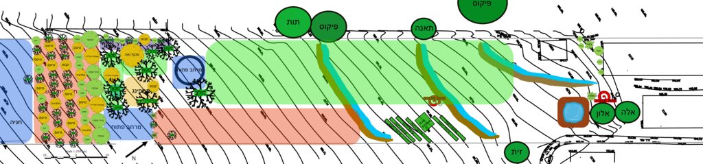
The general site plan (above) illustrates the full spatial organization of the food forest, structured into clearly defined functional zones that together create a balanced ecological and productive landscape (Note: original plan reproduced with captions in Hebrew). The outer perimeter consists of a protective tree belt designed to provide wind buffering, habitat continuity, and microclimate regulation. Inside this perimeter lies a series of densely planted clusters of mixed-species trees and support plants, forming the core forested zones of the design. These clusters contain a combination of canopy species, fruit trees, nitrogen-fixing support species, and understory elements arranged to promote ecological interactions and long-term resilience. Several open areas are intentionally integrated throughout the site, providing space for circulation, light penetration, future expansion, and community activities. The plan also includes a designated agricultural strip for annual vegetable production, strategically placed to benefit from the moderated microclimate created by the surrounding tree layers. Additional functional elements such as a compost area, shaded seating or gathering points, and access paths appear throughout the design, supporting both maintenance and educational use. Overall, the plan demonstrates a holistic integration of productive, ecological, and social spaces, emphasizing diversity, spatial layering, and regenerative land-use principles.
ឈ្មោះអ្នកនិពន្ធ:
Nitzan Betzer
កាលបរិច្ឆេទ:
01/06/2017
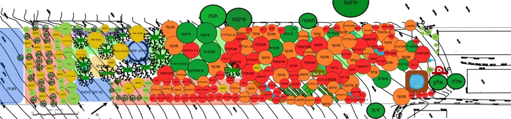
លក្ខណៈពិសេសនៃបច្ចេកទេស (ទាក់ទងនឺងគំនូរបច្ចេកទេស):
The planting plan (below) illustrates the full structural design of the food forest, showing a diverse mixture of perennial species arranged according to ecological function and spatial layout (Note: original plan reproduced with captions in Hebrew). Each color on the map represents a different botanical or functional category. The green circles indicate the major canopy and shade-providing trees that form the upper layer of the system. The red circles mark the fruit-bearing species distributed across the plot, including pomegranate, avocado, fig, loquat, mango, mulberry and others, representing the primary productive component of the mid-storey. The orange circles correspond to nitrogen-fixing trees and shrubs, strategically positioned to enrich soil fertility and support surrounding species through natural nutrient cycling. The yellow circles mark ornamental or habitat-supporting species that enhance biodiversity, microclimate regulation and ecological resilience. Together, these categories create a multi-layered mosaic in which canopy, fruit, support species and habitat elements interweave across the site. The design also includes designated open areas, compost space, perimeter rows and an agricultural strip for annual vegetables, demonstrating an intentional balance between ecological restoration, food production and functional zoning.
ឈ្មោះអ្នកនិពន្ធ:
Nitzan Betzer
កាលបរិច្ឆេទ:
01/06/2017
4.2 ព័ត៌មានទូទៅដែលពាក់ព័ន្ធនឹងការគណនាធាតុចូល និងថ្លៃដើម
កំណត់របៀបនៃការគណនាថ្លៃដើម និងធាតុចូល:
- ក្នុងតំបន់អនុវត្តបច្ចេកទេស
កំណត់ទំហំ និងឯកត្តាផ្ទៃដី:
1.5 acres
បើសិនប្រើឯកតាតាមតំបន់ សូមបញ្ជាក់តម្លៃបម្លែងវាទៅជាហិកតា (ឧ. 1 ហិកតា = 2.47 អា)៖ 1 ហិកតា =:
1 acre = 0.4 hectares
កំណត់រូបិយប័ណ្ណសម្រាប់ថ្លៃដើម:
- ដុល្លារ
កំណត់ថ្លៃឈ្នួលជាមធ្យមនៃការជួលកម្លាំងពលកម្មក្នុងមួយថ្ងៃ:
158.2
4.3 សកម្មភាពបង្កើត
| សកម្មភាព | រយៈពេល (រដូវកាល) | |
|---|---|---|
| 1. | Initial site assessment and mapping of soil condition and exposure | Late winter / early spring |
| 2. | Discontinuation of tillage and herbicide applications | Immediately prior to establishment |
| 3. | Soil preparation without deep tillage (light loosening, mulching base layer) | Early spring |
| 4. | Planting of trees in primary layout (skeleton layer) | Spring |
| 5. | Planting of shrubs and understory companion species | Late spring / early summer |
| 6. | Installation of organic mulch cover to protect soil and retain moisture | After planting (early summer) |
| 7. | Enrichment planting / filling gaps with additional groundcover species | Late summer / following spring |
| 8. | Protection of young trees/shrubs if needed (guards, shading, temporary watering) | First growing season |
| 9. | Establishment of biomass cycling (chop-and-drop, composting on-site) | After vegetation takes root |
| 10. | Transition into maintenance phase (reduced intervention, natural succession) | Once canopy begins forming |
4.4 ថ្លៃដើម និងធាតុចូលដែលត្រូវការសម្រាប់ការបង្កើតបច្ចេកទេស
| បញ្ជាក់ពីធាតុចូល | ឯកតា | បរិមាណ | ថ្លៃដើមក្នុងមួយឯកតា | ថ្លៃធាតុចូលសរុប | % នៃថ្លៃដើមដែលចំណាយដោយអ្នកប្រើប្រាស់ដី | |
|---|---|---|---|---|---|---|
| កម្លាំងពលកម្ម | Manual labour | Person-days | 139,0 | 158,2 | 21989,8 | 100,0 |
| សម្ភារៈ | Tools and maintenance equipment | 1,0 | 5000,0 | 5000,0 | 100,0 | |
| សម្ភារៈ | Tractor (for construction) | 1,0 | 7200,0 | 7200,0 | 100,0 | |
| សម្ភារៈដាំដុះ | Seedlings, cuttings, and seeds | 1,0 | 14000,0 | 14000,0 | 100,0 | |
| ជី និងសារធាតុពុល | Compost | 1,0 | 10500,0 | 10500,0 | 100,0 | |
| សម្ភារៈសាងសង់ | Irrigation system | 1,0 | 14500,0 | 14500,0 | 100,0 | |
| សម្ភារៈសាងសង់ | Pruned biomass mulch | 1,0 | 6500,0 | 6500,0 | 100,0 | |
| ថ្លៃដើមសរុបក្នុងការបង្កើតបច្ចេកទេស | 79689,8 | |||||
| ថ្លៃដើមសរុបក្នុងការបង្កើតបច្ចេកទេសគិតជាដុល្លារ | 79689,8 | |||||
ប្រសិនបើអ្នកប្រើប្រាស់ដីមិនមានថ្លៃដើម 100% សូមបញ្ជាក់ថានរណាដែលចំណាយថ្លៃដើមដែលនៅសល់:
Land user bore all costs: but note the primary purpose of this site is research and education. It is not intended to be a commercial enterprise, but to demonstrate principles and practices of sustainable land management. The income generated is not from crops but from research grants, workshops and community activities.
មតិយោបល់:
No chemical fertilizers or pesticides are used; fertilization is based solely on compost
4.5 សកម្មភាពថែទាំ
| សកម្មភាព | ពេលវេលា/ ភាពញឹកញាប់ | |
|---|---|---|
| 1. | Mulching with organic biomass (leaf litter, pruning residues, woodchips, etc.) | 2–3 times per year, mainly after rainy season and mid-summer |
| 2. | Selective pruning of trees and shrubs to maintain structure and light balance | Annually / as needed (late winter or autumn) |
| 3. | Enrichment planting and succession planting of understorey species | Seasonally, as ecosystem matures or gaps appear |
| 4. | Weeding by ecological suppression (groundcover strengthening) rather than removal | Continuous, low-intensity maintenance |
| 5. | Soil moisture conservation (biomass renewal / occasional supportive watering in drought years) | Seasonally during dry periods (as needed) |
| 6. | Monitoring soil condition and vegetation health | Ongoing, at least once per season |
| 7. | Replacement of failed or weak young plants | Annually during early growth seasons |
| 8. | Maintenance of biodiversity guilds / companion planting structure | Continuous, adaptive to natural succession |
4.6 កំណត់ថ្លៃដើមសម្រាប់ការថែទាំ/ សកម្មភាពរបស់បច្ចេកទេស (ក្នុងរយៈពេលមួយឆ្នាំ)
| បញ្ជាក់ពីធាតុចូល | ឯកតា | បរិមាណ | ថ្លៃដើមក្នុងមួយឯកតា | ថ្លៃធាតុចូលសរុប | % នៃថ្លៃដើមដែលចំណាយដោយអ្នកប្រើប្រាស់ដី | |
|---|---|---|---|---|---|---|
| កម្លាំងពលកម្ម | Manual labour | Person-days | 110,0 | 158,2 | 17402,0 | 100,0 |
| សម្ភារៈ | Equipment renewal and maintenance | 1,0 | 5000,0 | 5000,0 | 100,0 | |
| សម្ភារៈដាំដុះ | Cuttings and seeds | 1,0 | 4000,0 | 4000,0 | 100,0 | |
| ផ្សេងៗ | Water bills | 1,0 | 5500,0 | 5500,0 | 100,0 | |
| ផ្សេងៗ | Products selling kits | 1,0 | 2000,0 | 2000,0 | 100,0 | |
| ថ្លៃដើមសរុបសម្រាប់ការថែទាំដំណាំតាមបច្ចេកទេស | 33902,0 | |||||
| ថ្លៃដើមសរុបសម្រាប់ការថែទាំដំណាំតាមបច្ចេកទេសគិតជាដុល្លារ | 33902,0 | |||||
មតិយោបល់:
The establishment costs refer to the initial food forest area of approximately 1.5 acres, while the annual maintenance costs refer to the forest in its current state, covering about 3 acres. Land user bore all costs: but note that the primary purpose of this site is research and education. It is not intended to be a commercial enterprise, but to demonstrate principles and practices of sustainable land management. The income generated is not from crops but from research grants, workshops and community activities.
4.7 កត្តាសំខាន់បំផុតដែលមានឥទ្ធិពលដល់ការចំណាយ
ពណ៌នាពីកត្តាប៉ះពាល់ចម្បងៗទៅលើថ្លៃដើម:
The most significant cost factor, both during establishment and ongoing maintenance, is labour. All work is carried out manually using hand tools, and apart from the initial establishment phase, no heavy machinery is used
5. លក្ខណៈបរិស្ថានធម្មជាតិ និងមនុស្ស
5.1 អាកាសធាតុ
បរិមាណទឹកភ្លៀងប្រចាំឆ្នាំ
- < 250 មម
- 251-500 មម
- 501-750 មម
- 751-1,000 មម
- 1,001-1,500 មម
- 1,501-2,000 មម
- 2,001-3,000 មម
- 3,001-4,000 មម
- > 4,000 មម
បញ្ជាក់ឈ្មោះឯកសារយោងនៃស្ថានីយឧតុនិយម:
The climatic information for the food forest site was obtained from two sources: official data provided by the Israel Meteorological Service (IMS) and on-site measurements collected through a dedicated rain gauge installed as part of the research infrastructure. Together, these sources provide accurate local rainfall and climate monitoring for the plot.
តំបន់កសិអាកាសធាតុ
- មានភ្លៀងមធ្យម
5.2 សណ្ឋានដី
ជម្រាលជាមធ្យម:
- រាបស្មើ (0-2%)
- ជម្រាលតិចតួច (3-5%)
- មធ្យម (6-10%)
- ជម្រាលខ្ពស់បន្តិច (11-15%)
- ទីទួល (16-30%)
- ទីទួលចោត (31-60%)
- ទីទួលចោតខ្លាំង (>60%)
ទម្រង់ដី:
- ខ្ពង់រាប
- កំពូលភ្នំ
- ជម្រាលភ្នំ
- ជម្រាលទួល
- ជម្រាលជើងភ្នំ
- បាតជ្រលងភ្នំ
តំបន់តាមរយៈកម្ពស់ :
- 0-100 ម
- 101-500 ម
- 501-1,000 ម
- 1,001-1,500 ម
- 1,501-2,000 ម
- 2,001-2,500 ម
- 2,501-3,000 ម
- 3,001-4,000 ម
- > 4,000 ម
បញ្ជាក់ថាតើបច្ចេកទេសនេះត្រូវបានអនុវត្តន៍នៅក្នុង:
- មិនពាក់ព័ន្ធទាំងអស់
5.3 ដី
ជម្រៅដីជាមធ្យម:
- រាក់ខ្លាំង (0-20 សម)
- រាក់ (21-50 សម)
- មធ្យម (51-80 សម)
- ជ្រៅ (81-120 សម)
- ជ្រៅខ្លាំង (> 120 សម)
វាយនភាពដី (ស្រទាប់លើ):
- មធ្យម (ល្បាយ, ល្បាប់)
វាយនភាពដី (> 20 សម ស្រទាប់ក្នុង):
- មធ្យម (ល្បាយ, ល្បាប់)
សារធាតុសរីរាង្គនៅស្រទាប់ដីខាងលើ:
- ទាប (<1%)
5.4 ទឹកដែលអាចទាញមកប្រើប្រាស់បាន និងគុណភាពទឹក
នីវ៉ូទឹកក្រោមដី:
5-50 ម
ទឹកលើដីដែលអាចទាញយកប្រើប្រាស់បាន:
មិនមាន/ គ្មាន
គុណភាពទឹក (មិនបានធ្វើប្រត្តិកម្ម):
ទឹកសម្រាប់តែការធ្វើកសិកម្ម (ស្រោចស្រព)
គុណភាពទឹក គឺផ្តោតទៅលើ៖:
ទាំងទឹកក្រោមដី និងលើផ្ទៃដី
តើមានបញ្ហាភាពទឹកប្រៃហូរចូលមកដែរឬទេ?
ទេ
តើទឹកជំនន់កំពុងកើតមាននៅតំបន់នេះដែររឺទេ?
ទេ
5.5 ជីវៈចម្រុះ
ភាពសម្បូរបែបនៃប្រភេទ:
- ទាប
ភាពសម្បូរបែបនៃទីជម្រក:
- ទាប
មតិយោបល់ និងលក្ខណៈពិសេសផ្សេងទៀតលើជីវចម្រុះ:
Both species diversity and habitat diversity have transformed due to the establishment of the food forest, and are now both high. This is a very agrobiodiverse system.
5.6 លក្ខណៈនៃអ្នកប្រើប្រាស់ដីដែលអនុវត្តបច្ចេកទេស
នៅមួយកន្លែង ឬពនេចរ :
- នៅមួយកន្លែង
ទីផ្សារនៃប្រព័ន្ធផលិតកម្ម:
- សម្រាប់ហូបក្នុងគ្រួសារ (ផ្គត់ផ្គង់ខ្លួនឯង)
ចំណូលក្រៅកសិកម្ម:
- ច្រើនជាង 50% នៃចំណូល
កម្រិតជីវភាព:
- មធ្យម
ឯកជន ឬក្រុម:
- ធ្វើខ្លួនឯង/ គ្រួសារ
កម្រិតប្រើប្រាស់គ្រឿងយន្ត:
- ប្រើកម្លាំងពលកម្ម
យេនឌ័រ:
- ស្ត្រី
- បុរស
អាយុរបស់អ្នកប្រើប្រាស់ដី:
- វ័យកណ្តាល
5.7 ទំហំផ្ទៃដីជាមធ្យមនៃដីប្រើប្រាស់ដោយអ្នកប្រើប្រាស់ដី ក្នុងការអនុវត្តបច្ចេកទេស
- < 0.5 ហិកតា
- 0.5-1 ហិកតា
- 1-2 ហិកតា
- 2-5 ហិកតា
- 5-15 ហិកតា
- 15-50 ហិកតា
- 50-100 ហិកតា
- 100-500 ហិកតា
- 500-1,000 ហិកតា
- 1,000-10,000 ហិកតា
- > 10,000 ហិកតា
តើផ្ទៃដីនេះចាត់ទុកជាទំហំកម្រិតណាដែរ ខ្នាតតូច មធ្យម ឬខ្នាតធំ (ធៀបនឹងបរិបទតំបន់)?
- ខ្នាតតូច
មតិយោបល់:
The land user manages approximately 2–5 hectares in total, of which a portion is undergoing transition into a food forest system; this is considered small-scale in the local agricultural context
5.8 ភាពជាម្ចាស់ដី កម្មសិទ្ធប្រើប្រាស់ដី និងកម្មសិទ្ធប្រើប្រាស់ទឹក
ភាពជាម្ចាស់ដី:
- ឯកជន មានកម្មសិទ្ធ
កម្មសិទ្ធិប្រើប្រាស់ដី:
- ឯកជន
កម្មសិទ្ធប្រើប្រាស់ទឹក:
- ឯកជន
តើកម្មសិទ្ធប្រើប្រាស់ដី គឺផ្អែកលើប្រព័ន្ធច្បាប់បែបបុរាណ?
ទេ
5.9 ការប្រើប្រាស់សេវាកម្ម និងហេដ្ឋារចនាសម្ព័ន្ធ
សុខភាព:
- មិនល្អ
- មធ្យម
- ល្អ
ការអប់រំ:
- មិនល្អ
- មធ្យម
- ល្អ
ជំនួយបច្ចេកទេស:
- មិនល្អ
- មធ្យម
- ល្អ
ការងារ (ឧ. ការងារក្រៅកសិដ្ឋាន):
- មិនល្អ
- មធ្យម
- ល្អ
ទីផ្សារ:
- មិនល្អ
- មធ្យម
- ល្អ
ថាមពល:
- មិនល្អ
- មធ្យម
- ល្អ
ផ្លូវ និងការដឹកជញ្ជូន:
- មិនល្អ
- មធ្យម
- ល្អ
ទឹកផឹក និងអនាម័យ:
- មិនល្អ
- មធ្យម
- ល្អ
សេវាកម្មហិរញ្ញវត្ថុ:
- មិនល្អ
- មធ្យម
- ល្អ
6. ផលប៉ះពាល់ និងការសន្និដ្ឋាន
6.1 ផលប៉ះពាល់ក្នុងបរិវេណអនុវត្តបច្ចេកទេសដែលកើតមាន
ផលប៉ះពាល់លើសេដ្ឋកិច្ចសង្គម
ចំណូល និងថ្លៃដើម
ការចំណាយលើធាតុចូលកសិកម្ម
មតិយោបល់/ ការបញ្ជាក់:
Agricultural input expenses are very limited in this system. Since the site operates as a food forest rather than a conventional agricultural plot, nearly no external inputs are purchased. The management relies on ecological processes, on-site biomass, mulching, and manual care. Inputs are therefore minimal and do not reflect commercial-scale agricultural expenditure.
ភាពសម្បូរបែបប្រភពប្រាក់ចំណូល
មតិយោបល់/ ការបញ្ជាក់:
The plot was originally managed as a monoculture field that depended economically on agricultural production. Today, the food forest operates on a completely different model: its income is derived primarily from research activities, educational programs, workshops, and community engagement. Economic sustainability is no longer based on agricultural yield, as crop production is not the financial foundation of the site anymore.
ផលប៉ះពាល់ទៅលើវប្បធម៌សង្គម
ឱកាសវប្បធម៍
មតិយោបល់/ ការបញ្ជាក់:
The food forest contributes significantly to cultural opportunities in the area. It serves as a community-oriented space that hosts educational events, workshops, volunteer activities, and gatherings focused on sustainability and ecological awareness. The site fosters cultural exchange, strengthens community cohesion, and provides a shared environment for learning, creativity, and connection to nature.
ស្ថាប័នសហគមន៍
មតិយោបល់/ ការបញ្ជាក់:
Note: The food forest strengthens community institutions by collaborating with local educational programs, volunteer groups, and research initiatives. It provides a stable platform for schools, community organizations, and environmental groups to conduct activities, thereby reinforcing their role in community life and expanding their capacity for outreach and engagement.
ចំណេះដឹង SLM / ការធ្លាក់ចុះគុណភាពដី
មតិយោបល់/ ការបញ្ជាក់:
The food forest contributes to improved SLM and land-degradation knowledge by serving as a living demonstration site where restoration practices can be observed, tested, and monitored over time. It provides real-world evidence on soil recovery, biodiversity enhancement, and regenerative management, supporting both scientific research and practical learning for land users, students, and professionals.
ផលប៉ះពាល់ទៅលើអេកូឡូស៊ី
វដ្តទឹក/លំហូរ
លំហូរទឹកលើផ្ទៃដី
មតិយោបល់/ ការបញ្ជាក់:
The food forest reduces surface runoff through continuous vegetative cover, increased soil organic matter, and improved infiltration. The multi-layered perennial structure slows water movement, stabilizes the soil, and enhances water absorption, thereby decreasing erosion risk and minimizing overland flow during rainfall events.
រំហួត
មតិយោបល់/ ការបញ្ជាក់:
The food forest reduces soil surface evaporation through dense vegetative cover, shading from the multi-layered canopy, and increased soil organic matter. Mulching and groundcover plants further protect the soil surface, lowering temperatures at ground level and limiting direct exposure to sun and wind, which significantly decreases soil surface evaporative water loss.
ដី
សំណើមដី
មតិយោបល់/ ការបញ្ជាក់:
The food forest increases soil moisture by improving infiltration, enhancing organic matter content, and maintaining continuous groundcover. The multi-layered canopy moderates temperature and reduces evaporation, while mulch and living groundcovers retain water in the upper soil layers. Together, these features create a cooler, moister soil environment that supports long-term ecological function.
គម្របដី
មតិយោបល់/ ការបញ្ជាក់:
The food forest improves ground cover through the establishment of multi-layered perennial vegetation, including trees, shrubs, and living groundcovers. Mulch application and natural leaf litter further protect the soil surface, ensuring year-round coverage that reduces erosion, enhances soil health, and supports ecological stability.
ដីប្រេះ
មតិយោបល់/ ការបញ្ជាក់:
The food forest reduces soil crusting and surface sealing by increasing organic matter, maintaining continuous vegetative cover, and enhancing biological activity in the upper soil layers. Leaf litter, mulch, and root penetration prevent the formation of hard surface layers, while improved soil structure allows better infiltration and aeration, minimizing the risk of crust development.
វដ្តនៃសារធាតុចិញ្ចឹម/ការទទួលបាន
មតិយោបល់/ ការបញ្ជាក់:
The food forest enhances nutrient cycling and soil nutrient recharge through continuous biomass production, leaf litter accumulation, and root turnover. Nitrogen-fixing species, mulch, and on-site organic matter decomposition replenish soil nutrients naturally, while diverse plant strata promote active microbial communities that accelerate nutrient transformation and availability.
សារធាតុសរីរាង្គដី/ការបូនក្រោមដី
មតិយោបល់/ ការបញ្ជាក់:
The food forest increases soil organic matter and below-ground carbon through continuous inputs of leaf litter, root biomass, and decomposing mulch. The perennial, multi-layered vegetation system supports sustained carbon incorporation into the soil, while reduced disturbance and enhanced microbial activity further promote long-term carbon storage and soil organic matter accumulation.
ជីវចម្រុះ៖ ដំណាំ, សត្វ
ដំណាំគម្រប
មតិយោបល់/ ការបញ្ជាក់:
The food forest substantially increases vegetation cover by establishing multiple perennial layers - canopy trees, mid-storey species, shrubs, and groundcovers - that provide continuous, year-round biomass. This expanded plant cover protects the soil, supports ecological processes, and creates a more resilient and biodiverse landscape compared to the former monoculture field.
ជីវម៉ាស/ កាបូនលើដី
មតិយោបល់/ ការបញ្ជាក់:
The food forest increases above-ground biomass and carbon storage through the establishment of diverse perennial vegetation, including canopy trees, fruit species, shrubs, and herbaceous layers. As these plants grow, they accumulate significant living biomass, sequester carbon, and contribute to long-term ecological stability through continuous organic matter production and structural complexity.
ភាពសម្បូរបែបនៃរុក្ខជាតិ
មតិយោបល់/ ការបញ្ជាក់:
The food forest greatly increases plant diversity by integrating a wide range of tree species, fruit trees, nitrogen-fixing plants, shrubs, herbs, and groundcovers. This multi-strata design replaces the former single-crop system with a complex, species-rich community that enhances ecological resilience, supports wildlife, and promotes functional biodiversity across the site.
ភាពសម្បូរបែបនៃទីជំរក
មតិយោបល់/ ការបញ្ជាក់:
The food forest increases habitat diversity by creating a multi-layered structure that supports varied ecological niches. The combination of canopy trees, understory species, shrubs, groundcovers, open areas, and water features provides habitats for a wide range of insects, birds, and small wildlife. This structural and functional diversity replaces the uniform habitat of the former monoculture and greatly enhances overall ecosystem complexity.
ការកាត់បន្ថយហានិភ័យនៃគ្រោះមហន្តរាយ និងគ្រោះអាកាសធាតុ
ការបំភាយនៃកាបូន និងឧស្ម័នផ្ទះកញ្ចក់
មតិយោបល់/ ការបញ្ជាក់:
The food forest helps reduce carbon and greenhouse gas emissions by minimizing external inputs, eliminating chemical fertilizers, and avoiding soil disturbance that would otherwise release stored carbon. The perennial vegetation continuously sequesters carbon in both biomass and soil, while the system’s low-energy, regenerative management reduces emissions associated with conventional agricultural practices.
បញ្ជាក់ពីការប៉ាន់ស្មាននៃផលប៉ះពាល់ក្នុងបរិវេណអនុវត្តបច្ចេកទេស (វាស់វែង):
The assessment of on-site impacts combines both social-cultural learning processes and quantitative biophysical measurements. On the social, cultural, and economic side, the site hosts workshops, guided learning sessions, and community activities designed to understand the meaning, role, and value of the food forest for local stakeholders. These engagements provide qualitative insights into cultural benefits, community strengthening, and the educational function of the place. For the more tangible biophysical parameters – soil health, vegetation condition, biodiversity, and ecological recovery – the monitoring relies on analytical laboratory tests and systematic long-term sampling. Soil samples collected at different stages of the establishment process were analyzed for organic matter, nutrients, structure, and biological activity, providing a clear picture of soil improvement over time. In addition, the site is monitored through remote-sensing-based indicators developed in collaboration with the University of Haifa, which track temporal changes in vegetation cover, biomass, soil moisture proxies, and overall ecological function. Together, these qualitative and quantitative assessments offer a comprehensive understanding of the site’s development, documenting both the ecological restoration underway and the parallel social and educational impacts generated by the food forest.
6.2 ផលប៉ះពាល់ក្រៅបរិវេណអនុវត្តបច្ចេកទេសដែលកើតមាន
ផលប៉ះពាល់នៃឧស្ម័នផ្ទះកញ្ចក់
មតិយោបល់/ ការបញ្ជាក់:
Using IPCC Tier-1 methods (2006 Guidelines with the 2019 Refinement), we estimate annual removals from (i) mineral soil organic carbon (SOC) gains after conversion from tilled wheat to multistrata agroforestry, and (ii) incremental woody biomass growth. Mediterranean evidence suggests SOC increases on managed woody systems of ~0.2–1.0 t C ha⁻¹ yr⁻¹, while biomass increments in multistrata/silvo-arable agroforestry typically add ~0.8–2.5 t C ha⁻¹ yr⁻¹ in the establishment decades; together this yields ~1.0–3.5 t C ha⁻¹ yr⁻¹, i.e., ≈ 3.7–13 tCO₂e ha⁻¹ yr⁻¹ (3.67 conversion). For reporting we adopt the conservative lower bound until our paired soil cores (baseline vs. years 2/5/8) and tree allometry—supported by Sentinel-2 time-series—finish quantifying site-specific change. Sources: IPCC 2006/2019 AFOLU guidance; AR6 WGIII (AFOLU); Mediterranean meta-analyses of SOC/biomass in woody systems and agroforestry.
វាយតម្លៃផលប៉ះពាល់ក្រៅបរិវេណអនុវត្តបច្ចេកទេស (វាស់វែង):
Off-site impacts were assessed through a combination of qualitative and quantitative indicators that capture how the food-forest system influences the surrounding landscape and community beyond the plot boundaries. Hydrological effects were inferred from reduced surface runoff and improved infiltration within the site, which collectively lower downstream sedimentation and erosion risks; these implications were evaluated using rainfall records, soil-moisture trends, and comparison of runoff behavior between the restored area and adjacent conventionally managed fields. Vegetation development and canopy expansion – monitored through Sentinel-2 time-series and UAV imagery – provide additional evidence of landscape-scale improvements such as enhanced microclimatic buffering and habitat connectivity. Social and cultural off-site impacts were evaluated through participation in workshops, educational programs, and community events, which extend ecological knowledge and stewardship beyond the site itself. Together, these measurements and observations offer a coherent picture of how the food forest contributes to broader environmental and community benefits outside its physical boundaries.
6.3 ភាពប្រឈម និងភាពរួសនៃបច្ចេកទេសទៅនឹងការប្រែប្រួលអាកាសធាតុ និងគ្រោះអាកាសធាតុ/ គ្រោះមហន្តរាយ (ដែលដឹងដោយអ្នកប្រើប្រាស់ដី)
ការប្រែប្រួលអាកាសធាតុ
ការប្រែប្រួលអាកាសធាតុ
| រដូវកាល | កើនឡើង ឬថយចុះ | លក្ខណៈឆ្លើយតបនៃបច្ចេកទេសទៅនឹងការប្រែប្រួលអាកាសធាតុ | |
|---|---|---|---|
| សីតុណ្ហភាពប្រចាំឆ្នាំ | កើនឡើង | មធ្យម | |
| បរិមាណទឹកភ្លៀងប្រចាំឆ្នាំ | ថយចុះ | ល្អ |
គ្រោះអាកាសធាតុ (មហន្តរាយ)
គ្រោះមហន្តរាយធម្មជាតិ
| លក្ខណៈឆ្លើយតបនៃបច្ចេកទេសទៅនឹងការប្រែប្រួលអាកាសធាតុ | |
|---|---|
| ព្យុះភ្លៀងតាមតំបន់ | មធ្យម |
គ្រោះមហន្តរាយអាកាសធាតុ
| លក្ខណៈឆ្លើយតបនៃបច្ចេកទេសទៅនឹងការប្រែប្រួលអាកាសធាតុ | |
|---|---|
| រលកកម្តៅ | ល្អ |
| រាំងស្ងួត | ល្អ |
6.4 ការវិភាគថ្លៃដើម និងអត្ថប្រយោជន៍
តើផលចំណេញ និងថ្លៃដើមត្រូវបានប្រៀបធៀបគ្នាយ៉ាងដូចម្តេច (ទស្សនៈរបស់អ្នកប្រើប្រាស់ដី)?
រយៈពេលខ្លី:
អវិជ្ជមានតិចតួច
រយៈពេលវែង:
វិជ្ជមាន
តើផលចំណេញ និងការថែទាំ/ ជួសជុលត្រូវបានប្រៀបធៀបគ្នាយ៉ាងដូចម្តេច (ទស្សនៈរបស់អ្នកប្រើប្រាស់ដី)?
រយៈពេលខ្លី:
ប៉ះពាល់តិចតួចបំផុត
រយៈពេលវែង:
វិជ្ជមាន
មតិយោបល់:
The slightly negative short-term balance does not reflect external subsidies but rather the intentional design and purpose of the site. The food forest is not a commercial enterprise and was never intended to generate profit from agricultural production. Its primary function is research, education, and community engagement, and therefore its revenues come from workshops, collaborations, and research grants rather than crop sales. The short-term financial deficit simply reflects the fact that the landowners invest in a long-term ecological and educational project whose value is measured in environmental and social outcomes rather than immediate economic returns. It should not be interpreted as dependence on agricultural subsidies or market-based support.
6.5 ការទទួលយកបច្ចេកទេស
- តែមួយករណី /ពិសោធន៍
បើអាច សូមបញ្ជាក់ពីបរិមាណ (ចំនួនគ្រួសារ និង/ ឬតំបន់គ្របដណ្តប់):
One household: 1.5 acres
ក្នុងចំណោមគ្រួសារទាំងអស់ដែលបានអនុវត្តបច្ចេកទេស តើមានប៉ុន្មានគ្រួសារដែលចង់ធ្វើដោយខ្លួនឯង ដោយមិនទទួលបានសម្ភារៈលើកទឹកចិត្ត/ប្រាក់ឧបត្ថម្ភ?:
- 0-10%
6.6 ការបន្សុំា
តើថ្មីៗនេះ បច្ចេកទេសនេះត្រូវបានកែតម្រូវដើម្បីបន្ស៊ាំទៅនឹងស្ថានភាពប្រែប្រួលដែរឬទេ?
បាទ/ចា៎
បើឆ្លើយបាទ/ ចា៎ សូមកំណត់ថាតើស្ថានភាពប្រែប្រួលមួយណាត្រូវបានបន្ស៊ាំ:
- ការប្រែប្រួលអាកាសធាតុ/គ្រោះមហន្តរាយធម្មជាតិ
បញ្ជាក់ពីការបន្ស៊ាំនៃបច្ចេកទេស (ការរៀបចំ, ឧបករណ៍/ប្រភេទ ។ល។):
The design and composition of the food forest are continuously adapted as the system matures and as new insights emerge from ongoing learning by the landowners and collaborating researchers. Species selection, spatial arrangement, and management practices have been refined over time in response to observed ecological dynamics - such as canopy development, soil improvement, microclimatic changes, and species performance. Additional trees, shrubs, and groundcovers have been introduced to enhance diversity, strengthen ecological functions, and address emerging needs such as shade regulation, soil enrichment, or habitat creation. This adaptive approach reflects the core principle of the technology: the food forest is a living system that evolves through observation, experimentation, and evidence-based adjustments informed by both practical experience and scientific collaboration.
6.7 ភាពខ្លាំង/ គុណសម្បត្តិ/ ឱកាសនៃបច្ចេកទេស
| ភាពខ្លាំង/ គុណសម្បត្តិ/ ឱកាសនៅកន្លែងរបស់អ្នកប្រើប្រាស់ដី |
|---|
| Restores soil fertility and structure without relying on chemicals and reduces weed pressure naturally through permanent groundcover |
| Improves moisture retention and reduces drought stress over time and supports biodiversity and creates a healthier farm ecosystem |
| Transformational: turns degraded land into a productive long-term asset |
| ភាពខ្លាំង/ គុណសម្បត្តិ/ ឱកាស ទស្សនៈរបស់បុគ្គលសំខាន់ៗ |
|---|
| Demonstrates a replicable nature-based solution for restoring degraded agricultural soils in Mediterranean climates |
| Increases soil organic matter and biological activity, improving long-term soil function and carbon sequestration |
| Serves as a living demonstration site with high educational and upscaling potential for regenerative farming in the region |
6.8 ភាពខ្សោយ/ គុណវិបត្តិ/ ហានិភ័យនៃបច្ចេកទេស និងវិធីសាស្ត្រដោះស្រាយ
| ភាពខ្សោយ/ គុណវិបត្តិ/ ហានិភ័យ ទស្សនៈរបស់អ្នកប្រើប្រាស់ដី | តើបច្ចេកទេសទាំងនោះបានដោះស្រាយបញ្ហាដូចម្តេច? |
|---|---|
| Slow establishment phase before benefits become visible | Patience + phased planting; choose fast-growing pioneer species to accelerate canopy formation |
| Requires knowledge and ecological management skills | Ongoing guidance from experts / capacity building / training |
| Young plants vulnerable to drought during first summers | Supplemental irrigation in the first years and thicker mulching to reduce evaporation |
| ភាពខ្សោយ/ គុណវិបត្តិ/ ហានិភ័យ ទស្សនៈរបស់អ្នកចងក្រងឬបុគ្គលសំខាន់ៗ | តើបច្ចេកទេសទាំងនោះបានដោះស្រាយបញ្ហាដូចម្តេច? |
|---|---|
| Long ecological recovery timeline before system reaches full functionality | Use succession planning and pioneer/perennial nurse species to accelerate canopy closure and soil regeneration |
| Success depends on appropriate species selection for local microclimate and soil | Improve site-specific design using adaptive planting trials, monitoring, and locally adapted cultivars |
| Knowledge-intensive management compared to conventional systems | Provide technical training, extension support, and farmer-to-farmer learning |
| Restoration outcomes may vary with drought years and extreme heat events | Increase biomass cover, soil shading, and water retention strategies in early establishment years |
7. ឯកសារយោង និងវេបសាយ
7.1 វិធីសាស្ត្រ/ ប្រភពនៃព័ត៌មាន
- តាមការចុះទីវាល ការស្រាវជ្រាវនៅទីវាល
Field visits and surveys were conducted once every season on-site with the primary land user (one key informant), supplemented by technical assessments from the research team
- ការសម្ភាសន៍ជាមួយអ្នកប្រើប្រាស់ដី
One-on-one interviews were conducted with the primary land user (one key informant) at least once a year, focusing on management decisions, perceived benefits and challenges, and changes observed since the start of the transition
- ការសម្ភាសន៍ជាមួយអ្នកជំនាញ/ ឯកទេស
The expert input was provided by specialists involved in the University of Haifa restoration pilot
- ការចងក្រងពីរបាកការណ៍ និងឯកសារផ្សេងៗទៀតដែលមាន
7.2 ឯកសារយោងដែលបានចេញផ្សាយ
ចំណងជើង អ្នកនិពន្ធ ឆ្នាំ ISBN:
Zbedat, G., & Brook, A. (2025). Land Restoration Effectiveness Assessed by Satellite-Based Remote Sensing Technologies as A New Monitoring Approach. The International Archives of the Photogrammetry, Remote Sensing and Spatial Information Sciences, 48, 149-155.
មានប្រភពមកពីណា? ថ្លៃដើមប៉ុន្មាន?
Google Scholar
ចំណងជើង អ្នកនិពន្ធ ឆ្នាំ ISBN:
T. A. Cohen, A. Brook and G. Zbedat, "Long-Term Land Restoration Assessment Using Remote Sensing in Mediterranean Ecosystems," 2024 IEEE International Workshop on Metrology for Agriculture and Forestry (MetroAgriFor), Padua, Italy, 2024, pp. 179-183, doi: 10.1109/MetroAgriFor63043.2024.10948855.
មានប្រភពមកពីណា? ថ្លៃដើមប៉ុន្មាន?
Google Scholar
7.3 ការភ្ជាប់ទៅកាន់ព័ត៌មានពាក់ព័ន្ធលើប្រព័ន្ធអនឡាញ
ចំណងជើង/ ពណ៌នា:
React4Med site
វេបសាយ:
https://react4med.eu
ចំណងជើង/ ពណ៌នា:
Bethlehem of Galilee Food Forest Collection
វេបសាយ:
https://haifa.primo.exlibrisgroup.com/discovery/collectionDiscovery?vid=972HAI_MAIN:HAU&inst=972HAI_MAIN&collectionId=81263109080002791
ការតភ្ជាប់ និងម៉ូឌុល
ពង្រីកមើលទាំងអស់ បង្រួមទាំងអស់ការតភ្ជាប់
គ្មានការតភ្ជាប់
ម៉ូឌុល
គ្មានម៉ូឌុល