Kanda [ប្រទេសអាហ្វហ្គានិស្ថាន]
- ការបង្កើត៖
- បច្ចុប្បន្នភាព
- អ្នកចងក្រង៖ Aqila Haidery
- អ្នកកែសម្រួល៖ –
- អ្នកត្រួតពិនិត្យ Alexandra Gavilano
Kanda
technologies_1659 - ប្រទេសអាហ្វហ្គានិស្ថាន
ពិនិត្យមើលគ្រប់ផ្នែក
ពង្រីកមើលទាំងអស់ បង្រួមទាំងអស់1. ព័ត៌មានទូទៅ
1.2 ព័ត៌មានលម្អិតពីបុគ្គលសំខាន់ៗ និងស្ថាប័នដែលចូលរួមក្នុងការវាយតម្លៃ និងចងក្រងឯកសារនៃបច្ចេកទេស
អ្នកជំនាញឯកទេស SLM:
អ្នកជំនាញឯកទេស SLM:
អ្នកជំនាញឯកទេស SLM:
អ្នកជំនាញឯកទេស SLM:
Sediqi Ali Ahmad
Helvetas Swiss Intercooperation
ប្រទេសអាហ្វហ្គានិស្ថាន
អ្នកជំនាញឯកទេស SLM:
Sthapit Keshar
Helvetas Swiss Intercooperation
ប្រទេសអាហ្វហ្គានិស្ថាន
អ្នកជំនាញឯកទេស SLM:
Arbab Ziauddin
Sourakhak Watershed Committee, Kahmard
ប្រទេសអាហ្វហ្គានិស្ថាន
ឈ្មោះអង្គភាពមួយ (ច្រើន) ដែលបានចងក្រងឯកសារ/ វាយតម្លៃបច្ចេកទេស (បើទាក់ទង)
HELVETAS (Swiss Intercooperation)1.3 លក្ខខណ្ឌទាក់ទងទៅនឹងការប្រើប្រាស់ទិន្នន័យដែលបានចងក្រងតាមរយៈ វ៉ូខេត
អ្នកចងក្រង និង(បុគ្គលសំខាន់ៗ)យល់ព្រមទទួលយកនូវលក្ខខណ្ឌនានាទាក់ទងទៅនឹងការប្រើប្រាស់ទិន្នន័យដែលបានចងក្រងតាមរយៈវ៉ូខេត:
បាទ/ចា៎
2. ការពណ៌នាពីបច្ចេកទេស SLM
2.1 ការពណ៌នាដោយសង្ខេបពីបច្ចេកទេស
និយមន័យបច្ចេកទេស:
A traditional underground water tank carved out of rocks to collect rainfall and snow water and reduce evaporation losses.
2.2 ការពណ៌នាលម្អិតពីបច្ចេកទេស
ការពណ៌នា:
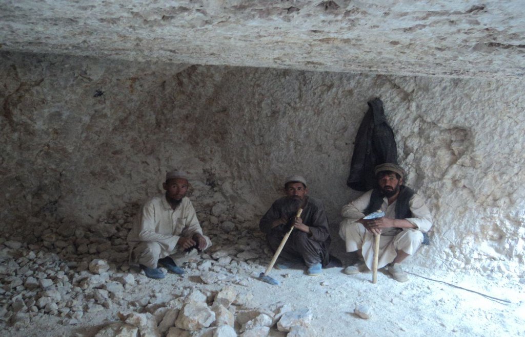
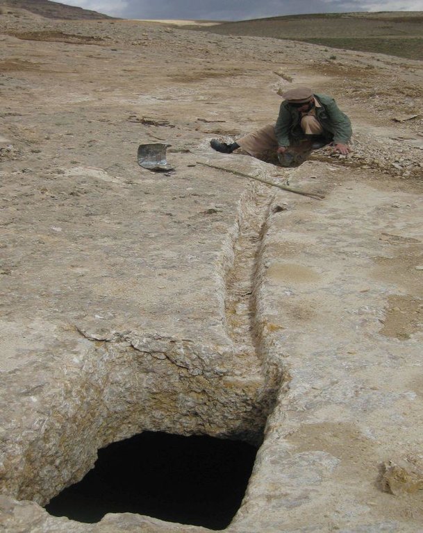
Kanda is an indigenous technology for collecting rain and snow melt. The technology comprises an underground tank carved out of rock (limestone), channels to convey the runoff into the underground tank or kanda and a rocky catchment from where runoff is collected. Kanda technology is applied in Afghanistan in many places, particularly in areas which experience scarcity of water for human beings, livestock and irrigation.
Purpose of the Technology: Due to high evaporation rates and low precipitation, harvesting runoff in open tanks is not an efficient way of water harvesting. HELVETAS Swiss Intercooperation is implementing community based watershed management projects in Kahmard district of Bamyan province (Afghanistan) since 2008 with financial support from the International Swiss Re Award for sustainable watershed management (2009) and the Swiss Agency for Development and Cooperation (SDC). One of the activities for sustainable watershed management is plantation of fruit and non-fruit trees in the selected watersheds (upland areas) which were used for grazing and extraction of vegetation for domestic use. Due to water scarcity in the upland areas, irrigation of the planted saplings becomes very difficult and water has to be transported on donkey from far locations. To overcome this constraint, Kanda was identified as the most potent technology for harvesting runoff and snow melt.
Establishment / maintenance activities and inputs: For constructing Kandas, Kanda makers from Dara-e Suf district in Samangan province had to employed as there are no experts in Kahmard. Based on feasibility studies, eight kandas have been constructed including 4 kandas in Sourakhak wa-tershed and 4 in Baqa Kushta watershed. The size of each kanda is 6 m length, 6 m in width and 3 m in height. To convey the runoff into the tank, 10-20 m long graded channels were carved out of the rocks. The establishment cost of one Kan-da was approximately US$ 7163. Kanda making requires special skills, especially when it is carved out of rocks. A kanda maker has sound understanding of the area’s geology, and this wisdom is gained through learning by doing and ances-tors.. In Kahmard, 2-3 experts worked for 4-5 months for one Kanda.
Natural / human environment: In 2012, due to sufficient rains, 2 Kandas which did not have leakage problems in Sourakhak watershed got full with runoff water, which was then used for irrigating 6500 saplings seven times during the year. Kahmard district has a semi-arid cli-mate. Some years are dry with rainfall of about 190 mm. Considering this context, it becomes very necessary to tap rainwater, especially in the rainfed uplands, and use it for irrigating saplings or for livestock.
2.3 រូបភាពនៃបច្ចេកទេស
2.5 ប្រទេស/តំបន់/ទីតាំងកន្លែង ដែលបច្ចេកទេសត្រូវបានអនុវត្ត និងបានគ្រប់ដណ្តប់ដោយការវាយតម្លៃនេះ
ប្រទេស:
ប្រទេសអាហ្វហ្គានិស្ថាន
តំបន់/រដ្ឋ/ខេត្ត:
Bamyan
បញ្ជាក់បន្ថែមពីលក្ខណៈនៃទីតាំង:
Kahmard
បញ្ជាក់ពីការសាយភាយនៃបច្ចេកទេស:
- អនុវត្តនៅកន្លែងជាក់លាក់មួយ/ ប្រមូលផ្តុំនៅតំបន់តូចៗ
មតិយោបល់:
Total area covered by the SLM Technology is 0.005 km2.
2.6 កាលបរិច្ឆេទនៃការអនុវត្ត
ប្រសិនបើមិនច្បាស់ឆ្នាំ សូមបញ្ជាក់កាលបរិច្ឆេទដែលប្រហាក់ប្រហែល:
- ច្រើនជាង 50 ឆ្នាំមុន (ប្រពៃណី)
2.7 ការណែនាំពីបច្ចេកទេស
សូមបញ្ជាក់តើបច្ចេកទេសត្រូវបានណែនាំឱ្យអនុវត្តដោយរបៀបណា:
- តាមរយៈគម្រោង / អន្តរាគមន៍ពីខាងក្រៅ
មតិយោបល់ (ប្រភេទនៃគម្រោង ។ល។):
Kanda technology is an age old water harvesting traditional technology.
3. ចំណាត់ថ្នាក់នៃបច្ចេកទេស SLM
3.1 គោលបំណងចម្បង (១ ឬច្រើន) នៃបច្ចេកទេសនេះ
- access to water
3.2 ប្រភេទដីប្រើប្រាស់មួយប្រភេទ (ច្រើនប្រភេទ) ដែលបានអនុវត្តបច្ចេកទេស

ដីសម្រាប់ចិញ្ចឹមសត្វ
វាលស្មៅធំៗ:
- ពាក់កណ្តាលពនេចរ
ដីវាលស្មៅតូចៗ/ ផលិតកម្មចំណី:
- បង្កើនវាលស្មៅ
ប្រភេទសត្វ:
- សត្វពពែ
- សត្វចៀម
មតិយោបល់:
Major land use problems (compiler’s opinion): Scarcity of water in the upland makes plantation activities and livestock productivity difficult. Carrying water from far places for irrigating plants is an expensive activity.
Major land use problems (land users’ perception): Degraded upland watershed resulting severe flash flood.
Forest products and services: timber, fuelwood, fruits and nuts, grazing / browsing, nature conservation / protection, protection against natural hazards
Other forest products and services: flash flood
Future (final) land use (after implementation of SLM Technology): Grazing land: Gi: Intensive grazing/ fodder production
Longest growing period in days: 90; Longest growing period from month to month: March-July
3.3 បន្ទាប់ពីអនុវត្តបច្ចេកទេស តើដីប្រើប្រាស់មានការប្រែប្រួលដែររឺទេ?

ដីសម្រាប់ចិញ្ចឹមសត្វ
- Extensive grazing
3.4 ការផ្គត់ផ្គង់ទឹក
ការផ្គត់ផ្គង់ទឹកនៅកន្លែងអនុវត្តបច្ចេកទេស:
- ទឹកភ្លៀង
3.5 ក្រុម SLM ដែលបច្ចេកទេសស្ថិតនៅក្នុង
- ការស្តុកទុកទឹក
3.6 វិធានការ SLM ដែលបញ្ចូលនូវបច្ចេកទេស

វិធានការរចនាស័ម្ពន្ធ
- S11: ផ្សេងៗ
មតិយោបល់:
Specification of other structural measures: Under ground cistern
3.7 កំណត់ប្រភេទនៃការធ្លាក់ចុះគុណភាពដីសំខាន់ៗដែលបច្ចេកទេសនេះបានដោះស្រាយ

ការហូរច្រោះដីដោយសារទឹក
- Wt: ការបាត់ដីស្រទាប់លើដោយការហូរច្រោះ

ការធ្លាក់ចុះជីវសាស្ត្រនៃដី
- Bc: ការថយចុះនូវគម្របរុក្ខជាតិ
មតិយោបល់:
Secondary types of degradation addressed: Wt: loss of topsoil / surface erosion
Main causes of degradation: over-exploitation of vegetation for domestic use (Bush collection for fire wood), overgrazing (By sheep and goets), droughts (Natural climate phenomenon), land tenure (Common land without good management), poverty / wealth, governance / institutional (Lack of organizationals for organization for supporting management of common resources.)
Secondary causes of degradation: crop management (annual, perennial, tree/shrub) (Rainfed agriculture), Heavy / extreme rainfall (intensity/amounts) (Change in climate patterns), population pressure (Fast increasing population which depands on natural resources for livelihoods), war and conflicts (Leading to uncontrolled cutting down of trees and shrubes)
3.8 ការពារ កាត់បន្ថយ ឬស្តារឡើងវិញនៃការធ្លាក់ចុះគុណភាពដី
បញ្ជាក់ពីគោលដៅរបស់បច្ចេកទេស ដែលផ្តោតទៅការធ្លាក់ចុះគុណភាពដី:
- ការជួសជុល/ ស្តារឡើងវិញនៃឱនភាពដីធ្ងន់ធ្ងរ
4. បច្ចេកទេសជាក់លាក់ សកម្មភាពអនុវត្ត ធាតុចូល និងថ្លៃដើម
4.1 គំនូសបច្ចេកទេសនៃបច្ចេកទេសនេះ
លក្ខណៈពិសេសនៃបច្ចេកទេស (ទាក់ទងនឺងគំនូរបច្ចេកទេស):
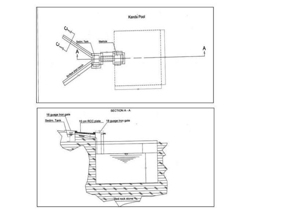
Technical drawing of a Kanda constructed at Baqa Kushta watershed in Kahmard district (Bamyan province).
Size of one Kanda tank:
Length:6m
Width :6m
Height:3m
108 cu.m water can be stored in one Kanda.
Location: Baqa Koshta watershed. Kahmard
Date: 24/03/2013
Technical knowledge required for field staff / advisors: high
Technical knowledge required for land users: high
Main technical functions: control of concentrated runoff: retain / trap, water harvesting / increase water supply, Reduction in evaporation and seepage losses
Secondary technical functions: improvement of ground cover
Structural measure: cistern(from rock)
Depth of ditches/pits/dams (m): 3
Width of ditches/pits/dams (m): 6
Length of ditches/pits/dams (m): 6
Construction material (other): Constructed from rock
ឈ្មោះអ្នកនិពន្ធ:
Helvetas Swiss Intercooperatio, Kabul Afghanistan
4.2 ព័ត៌មានទូទៅដែលពាក់ព័ន្ធនឹងការគណនាធាតុចូល និងថ្លៃដើម
កំណត់រូបិយប័ណ្ណសម្រាប់ថ្លៃដើម:
- ដុល្លារ
កំណត់ថ្លៃឈ្នួលជាមធ្យមនៃការជួលកម្លាំងពលកម្មក្នុងមួយថ្ងៃ:
5
4.4 ថ្លៃដើម និងធាតុចូលដែលត្រូវការសម្រាប់ការបង្កើតបច្ចេកទេស
| បញ្ជាក់ពីធាតុចូល | ឯកតា | បរិមាណ | ថ្លៃដើមក្នុងមួយឯកតា | ថ្លៃធាតុចូលសរុប | % នៃថ្លៃដើមដែលចំណាយដោយអ្នកប្រើប្រាស់ដី | |
|---|---|---|---|---|---|---|
| កម្លាំងពលកម្ម | Labour | kanda | 1,0 | 5640,0 | 5640,0 | 15,0 |
| សម្ភារៈ | Equipement | kanda | 1,0 | 458,0 | 458,0 | |
| សម្ភារៈសាងសង់ | Materials | kanda | 1,0 | 1065,0 | 1065,0 | 8,0 |
| ថ្លៃដើមសរុបក្នុងការបង្កើតបច្ចេកទេស | 7163,0 | |||||
| ថ្លៃដើមសរុបក្នុងការបង្កើតបច្ចេកទេសគិតជាដុល្លារ | 7163,0 | |||||
មតិយោបល់:
Duration of establishment phase: 0 month(s)
4.5 សកម្មភាពថែទាំ
| សកម្មភាព | ពេលវេលា/ ភាពញឹកញាប់ | |
|---|---|---|
| 1. | Cleaning of the canals and Kanda | once/year |
4.6 កំណត់ថ្លៃដើមសម្រាប់ការថែទាំ/ សកម្មភាពរបស់បច្ចេកទេស (ក្នុងរយៈពេលមួយឆ្នាំ)
| បញ្ជាក់ពីធាតុចូល | ឯកតា | បរិមាណ | ថ្លៃដើមក្នុងមួយឯកតា | ថ្លៃធាតុចូលសរុប | % នៃថ្លៃដើមដែលចំណាយដោយអ្នកប្រើប្រាស់ដី | |
|---|---|---|---|---|---|---|
| កម្លាំងពលកម្ម | Cleaning of the canals and Kanda | persons/day/kanda | 2,0 | 5,0 | 10,0 | 100,0 |
| ថ្លៃដើមសរុបសម្រាប់ការថែទាំដំណាំតាមបច្ចេកទេស | 10,0 | |||||
| ថ្លៃដើមសរុបសម្រាប់ការថែទាំដំណាំតាមបច្ចេកទេសគិតជាដុល្លារ | 10,0 | |||||
មតិយោបល់:
The kanda is for water collection which runoff and snow melt. The usage of water for sapling irrigation because there is upland and no water resources.
5. លក្ខណៈបរិស្ថានធម្មជាតិ និងមនុស្ស
5.1 អាកាសធាតុ
បរិមាណទឹកភ្លៀងប្រចាំឆ្នាំ
- < 250 មម
- 251-500 មម
- 501-750 មម
- 751-1,000 មម
- 1,001-1,500 មម
- 1,501-2,000 មម
- 2,001-3,000 មម
- 3,001-4,000 មម
- > 4,000 មម
តំបន់កសិអាកាសធាតុ
Thermal climate class: temperate
5.2 សណ្ឋានដី
ជម្រាលជាមធ្យម:
- រាបស្មើ (0-2%)
- ជម្រាលតិចតួច (3-5%)
- មធ្យម (6-10%)
- ជម្រាលខ្ពស់បន្តិច (11-15%)
- ទីទួល (16-30%)
- ទីទួលចោត (31-60%)
- ទីទួលចោតខ្លាំង (>60%)
ទម្រង់ដី:
- ខ្ពង់រាប
- កំពូលភ្នំ
- ជម្រាលភ្នំ
- ជម្រាលទួល
- ជម្រាលជើងភ្នំ
- បាតជ្រលងភ្នំ
តំបន់តាមរយៈកម្ពស់ :
- 0-100 ម
- 101-500 ម
- 501-1,000 ម
- 1,001-1,500 ម
- 1,501-2,000 ម
- 2,001-2,500 ម
- 2,501-3,000 ម
- 3,001-4,000 ម
- > 4,000 ម
5.3 ដី
ជម្រៅដីជាមធ្យម:
- រាក់ខ្លាំង (0-20 សម)
- រាក់ (21-50 សម)
- មធ្យម (51-80 សម)
- ជ្រៅ (81-120 សម)
- ជ្រៅខ្លាំង (> 120 សម)
វាយនភាពដី (ស្រទាប់លើ):
- គ្រើម/ មានពន្លឺ (ខ្សាច់)
សារធាតុសរីរាង្គនៅស្រទាប់ដីខាងលើ:
- ទាប (<1%)
បើអាចសូមភ្ជាប់ការពណ៌នាពីដីឱ្យបានច្បាស់ ឬព័ត៌មានដែលអាចទទួលបាន ឧ. ប្រភេទដី, pH ដី/ ជាតិអាស៊ីត, សមត្ថភាពផ្លាស់ប្តូរកាចុង, វត្តមាននីត្រូសែន, ភាពប្រៃ ។ល។:
Soil depth on average: Because there is fully of rocks.
Soil texture: Mostly rocky
Topsoil organic matter: Because there is erosion
Soil fertility is low (Loss by wind and water erosion)
Soil drainage / infiltration is poor because there is fully of rock
Soil water storage capacity because of rocky catchment
5.4 ទឹកដែលអាចទាញមកប្រើប្រាស់បាន និងគុណភាពទឹក
នីវ៉ូទឹកក្រោមដី:
> 50 ម
ទឹកលើដីដែលអាចទាញយកប្រើប្រាស់បាន:
មិនមាន/ គ្មាន
គុណភាពទឹក (មិនបានធ្វើប្រត្តិកម្ម):
ទឹកសម្រាប់តែការធ្វើកសិកម្ម (ស្រោចស្រព)
5.5 ជីវៈចម្រុះ
ភាពសម្បូរបែបនៃប្រភេទ:
- ទាប
5.6 លក្ខណៈនៃអ្នកប្រើប្រាស់ដីដែលអនុវត្តបច្ចេកទេស
ទីផ្សារនៃប្រព័ន្ធផលិតកម្ម:
- ពាក់កណ្តាលពាណិជ្ជកម្ម (ផ្គត់ផ្គង់ខ្លួនឯង/ ពាណិជ្ជកម្ម)
ចំណូលក្រៅកសិកម្ម:
- 10-50% នៃចំណូល
កម្រិតជីវភាព:
- មិនល្អ
- មធ្យម
ឯកជន ឬក្រុម:
- ជាក្រុម/ សហគមន៍
កម្រិតប្រើប្រាស់គ្រឿងយន្ត:
- ប្រើកម្លាំងពលកម្ម
យេនឌ័រ:
- បុរស
សូមបញ្ជាក់ពីលក្ខណៈពាក់ព័ន្ធផ្សេងទៀតអំពីអ្នកប្រើប្រាស់ដី:
Difference in the involvement of women and men: Because there is to much workload
Population density: 10-50 persons/km2
Annual population growth: 2% - 3%
10% of the land users are rich.
40% of the land users are average wealthy.
50% of the land users are poor.
5.7 ទំហំផ្ទៃដីជាមធ្យមនៃដីប្រើប្រាស់ដោយអ្នកប្រើប្រាស់ដី ក្នុងការអនុវត្តបច្ចេកទេស
- < 0.5 ហិកតា
- 0.5-1 ហិកតា
- 1-2 ហិកតា
- 2-5 ហិកតា
- 5-15 ហិកតា
- 15-50 ហិកតា
- 50-100 ហិកតា
- 100-500 ហិកតា
- 500-1,000 ហិកតា
- 1,000-10,000 ហិកតា
- > 10,000 ហិកតា
តើផ្ទៃដីនេះចាត់ទុកជាទំហំកម្រិតណាដែរ ខ្នាតតូច មធ្យម ឬខ្នាតធំ (ធៀបនឹងបរិបទតំបន់)?
- ខ្នាតតូច
5.8 ភាពជាម្ចាស់ដី កម្មសិទ្ធប្រើប្រាស់ដី និងកម្មសិទ្ធប្រើប្រាស់ទឹក
ភាពជាម្ចាស់ដី:
- រដ្ឋ
កម្មសិទ្ធិប្រើប្រាស់ដី:
- ជាក្រុម (មានដែនកំណត់)
កម្មសិទ្ធប្រើប្រាស់ទឹក:
- ជាក្រុម (មានដែនកំណត់)
5.9 ការប្រើប្រាស់សេវាកម្ម និងហេដ្ឋារចនាសម្ព័ន្ធ
សុខភាព:
- មិនល្អ
- មធ្យម
- ល្អ
ការអប់រំ:
- មិនល្អ
- មធ្យម
- ល្អ
ជំនួយបច្ចេកទេស:
- មិនល្អ
- មធ្យម
- ល្អ
ការងារ (ឧ. ការងារក្រៅកសិដ្ឋាន):
- មិនល្អ
- មធ្យម
- ល្អ
ទីផ្សារ:
- មិនល្អ
- មធ្យម
- ល្អ
ថាមពល:
- មិនល្អ
- មធ្យម
- ល្អ
ផ្លូវ និងការដឹកជញ្ជូន:
- មិនល្អ
- មធ្យម
- ល្អ
ទឹកផឹក និងអនាម័យ:
- មិនល្អ
- មធ្យម
- ល្អ
សេវាកម្មហិរញ្ញវត្ថុ:
- មិនល្អ
- មធ្យម
- ល្អ
6. ផលប៉ះពាល់ និងការសន្និដ្ឋាន
6.1 ផលប៉ះពាល់ក្នុងបរិវេណអនុវត្តបច្ចេកទេសដែលកើតមាន
ផលប៉ះពាល់លើសេដ្ឋកិច្ចសង្គម
ផលិតផល
ហានិភ័យនៃភាពបរាជ័យរបស់ផលិតកម្ម
ទឹកដែលអាចទាញមកប្រើប្រាស់បាន និងគុណភាពទឹក
ទឹកបរិភោគដែលអាចទាញយកមកប្រើប្រាស់បាន
គុណភាពទឹកបរិភោគ
ចំណូល និងថ្លៃដើម
បន្ទុកការងារ
ផលប៉ះពាល់ទៅលើសេដ្ឋកិច្ចសង្គមផ្សេងៗ
expense for construction
ផលប៉ះពាល់ទៅលើវប្បធម៌សង្គម
ចំណេះដឹង SLM / ការធ្លាក់ចុះគុណភាពដី
livelihood and human well-being
មតិយោបល់/ ការបញ្ជាក់:
Increased availability of water for small scale irrigation such as trees, sapling and livestock and increase successful afforestation in dry land areas which in the longer term will lead to increased income, fuel wood and timber for land user and greener watersheds
aesthetic value due to greener watershed
ផលប៉ះពាល់ទៅលើអេកូឡូស៊ី
វដ្តទឹក/លំហូរ
ការប្រមូលស្តុកទុកទឹក
លំហូរទឹកលើផ្ទៃដី
មតិយោបល់/ ការបញ្ជាក់:
due to water harvesting
ផលប៉ះពាល់ទៅលើអេកូឡូស៊ីផ្សេងៗ
sediments due to excavation of rocks
6.2 ផលប៉ះពាល់ក្រៅបរិវេណអនុវត្តបច្ចេកទេសដែលកើតមាន
ទឹកជំនន់ខ្សែទឹកខាងក្រោម
ខូចខាតដល់ហេដ្ឋារចនាសម្ព័ន្ធសាធារណៈ/ឯកជន
Contributes to flash flood risk reduction by supporting regreening effort
6.3 ភាពប្រឈម និងភាពរួសនៃបច្ចេកទេសទៅនឹងការប្រែប្រួលអាកាសធាតុ និងគ្រោះអាកាសធាតុ/ គ្រោះមហន្តរាយ (ដែលដឹងដោយអ្នកប្រើប្រាស់ដី)
ការប្រែប្រួលអាកាសធាតុ
ការប្រែប្រួលអាកាសធាតុ
| រដូវកាល | កើនឡើង ឬថយចុះ | លក្ខណៈឆ្លើយតបនៃបច្ចេកទេសទៅនឹងការប្រែប្រួលអាកាសធាតុ | |
|---|---|---|---|
| សីតុណ្ហភាពប្រចាំឆ្នាំ | កើនឡើង | ល្អ |
គ្រោះអាកាសធាតុ (មហន្តរាយ)
គ្រោះមហន្តរាយធម្មជាតិ
| លក្ខណៈឆ្លើយតបនៃបច្ចេកទេសទៅនឹងការប្រែប្រួលអាកាសធាតុ | |
|---|---|
| ព្យុះភ្លៀងតាមតំបន់ | ល្អ |
| ព្យុះកំបុតត្បូងតាមតំបន់ | ល្អ |
គ្រោះមហន្តរាយអាកាសធាតុ
| លក្ខណៈឆ្លើយតបនៃបច្ចេកទេសទៅនឹងការប្រែប្រួលអាកាសធាតុ | |
|---|---|
| រាំងស្ងួត | ល្អ |
គ្រោះមហន្តរាយទឹក
| លក្ខណៈឆ្លើយតបនៃបច្ចេកទេសទៅនឹងការប្រែប្រួលអាកាសធាតុ | |
|---|---|
| ទឹកជំនន់ទូទៅ (ទន្លេ) | ល្អ |
ផលវិបាកដែលទាក់ទងនឹងបរិយាកាសផ្សេងៗទៀត
ផលវិបាកដែលទាក់ទងនឹងបរិយាកាសផ្សេងៗទៀត
| លក្ខណៈឆ្លើយតបនៃបច្ចេកទេសទៅនឹងការប្រែប្រួលអាកាសធាតុ | |
|---|---|
| កាត់បន្ថយពេលដាំដុះ | ល្អ |
6.4 ការវិភាគថ្លៃដើម និងអត្ថប្រយោជន៍
តើផលចំណេញ និងថ្លៃដើមត្រូវបានប្រៀបធៀបគ្នាយ៉ាងដូចម្តេច (ទស្សនៈរបស់អ្នកប្រើប្រាស់ដី)?
រយៈពេលខ្លី:
វិជ្ជមាន
រយៈពេលវែង:
វិជ្ជមានខ្លាំង
តើផលចំណេញ និងការថែទាំ/ ជួសជុលត្រូវបានប្រៀបធៀបគ្នាយ៉ាងដូចម្តេច (ទស្សនៈរបស់អ្នកប្រើប្រាស់ដី)?
រយៈពេលខ្លី:
វិជ្ជមានខ្លាំង
រយៈពេលវែង:
វិជ្ជមានខ្លាំង
មតិយោបល់:
This technology is very positive and useful for land users and collected the water for irrigation and livestock.
6.5 ការទទួលយកបច្ចេកទេស
មតិយោបល់:
Comments on acceptance with external material support: It is an indigenous technology applied in many other districts of Afghanistan in Dara-e Suf and Ruy-i Doab districts of Samangan province by several families either collectively or privately without external support. In Dare-e Suf are not constructed inside of rocks but in soil.
6.7 ភាពខ្លាំង/ គុណសម្បត្តិ/ ឱកាសនៃបច្ចេកទេស
| ភាពខ្លាំង/ គុណសម្បត្តិ/ ឱកាសនៅកន្លែងរបស់អ្នកប្រើប្រាស់ដី |
|---|
|
The technology supports plantation activities in sites which are far from perennial water sources How can they be sustained / enhanced? The collected water should be used efficiently during irrigation by combining with conservation measures like mulching, drip or pitcher irrigation |
|
As the kanda catchment is rocky, infiltration losses are minimized and most of the surface runoff is harvested How can they be sustained / enhanced? The channel must be constructed properly so that all runoff is trapped and conveyed to the Kanda. |
| ភាពខ្លាំង/ គុណសម្បត្តិ/ ឱកាស ទស្សនៈរបស់បុគ្គលសំខាន់ៗ |
|---|
|
An indigenous multipurpose technology How can they be sustained / enhanced? Kanda size can be improved if the catchment area and precipitation amount are considered. This also depends on availability of long-term rainfall data. |
|
Requires minimum maintenance when constructed properly How can they be sustained / enhanced? Kanda, conveyance canals, sediment pits and catchment areas should be cleaned. If any leakages occur in the tank, they should be sealed. |
6.8 ភាពខ្សោយ/ គុណវិបត្តិ/ ហានិភ័យនៃបច្ចេកទេស និងវិធីសាស្ត្រដោះស្រាយ
| ភាពខ្សោយ/ គុណវិបត្តិ/ ហានិភ័យ ទស្សនៈរបស់អ្នកប្រើប្រាស់ដី | តើបច្ចេកទេសទាំងនោះបានដោះស្រាយបញ្ហាដូចម្តេច? |
|---|---|
| Due to a lack of geological and hydro-meteorological information, it is not possible to prepare precise and cost-effective kanda proposals | Make best use of traditional wisdom, install hydro-met stations if possible and make adjustments based on regular monitoring. |
| If the kanda and sediment trap tanks are not cleaned regularly and the kanda opening is not covered, sedimentation can be problem leading to reduced Kanda capacity and also animals could fall | Cleaning and maintenance works must be carried out by the local people every year before spring rains. The openings must be covered. |
| Due to availability of water, there can be grazing pressure near the Kanda | Watershed committee members and guards should ensure that the site is protected from over grazing. Construct Kandas outside the selected watershed for livestock purposes. |
| ភាពខ្សោយ/ គុណវិបត្តិ/ ហានិភ័យ ទស្សនៈរបស់អ្នកចងក្រងឬបុគ្គលសំខាន់ៗ | តើបច្ចេកទេសទាំងនោះបានដោះស្រាយបញ្ហាដូចម្តេច? |
|---|---|
| Establishment cost is high if the catchment is rocky | Needs external support during the establishment phase |
| Lack of kanda makers in some districts like Kahmard | Get kanda makers from other districts and build capacities of interested local people. |
7. ឯកសារយោង និងវេបសាយ
7.1 វិធីសាស្ត្រ/ ប្រភពនៃព័ត៌មាន
7.3 ការភ្ជាប់ទៅកាន់ព័ត៌មានពាក់ព័ន្ធលើប្រព័ន្ធអនឡាញ
វេបសាយ:
www.wocat.net(Online Technology Database)
ការតភ្ជាប់ និងម៉ូឌុល
ពង្រីកមើលទាំងអស់ បង្រួមទាំងអស់ការតភ្ជាប់
គ្មានការតភ្ជាប់
ម៉ូឌុល
គ្មានម៉ូឌុល


