Monitoring and Management of Agroforestry using SmartAG [ប្រទេសព័រទុយហ្គាល់]
- ការបង្កើត៖
- បច្ចុប្បន្នភាព
- អ្នកចងក្រង៖ Patrícia Lourenço
- អ្នកកែសម្រួល៖ –
- អ្នកត្រួតពិនិត្យច្រើនទៀត៖ Joana Eichenberger, William Critchley, Rima Mekdaschi Studer
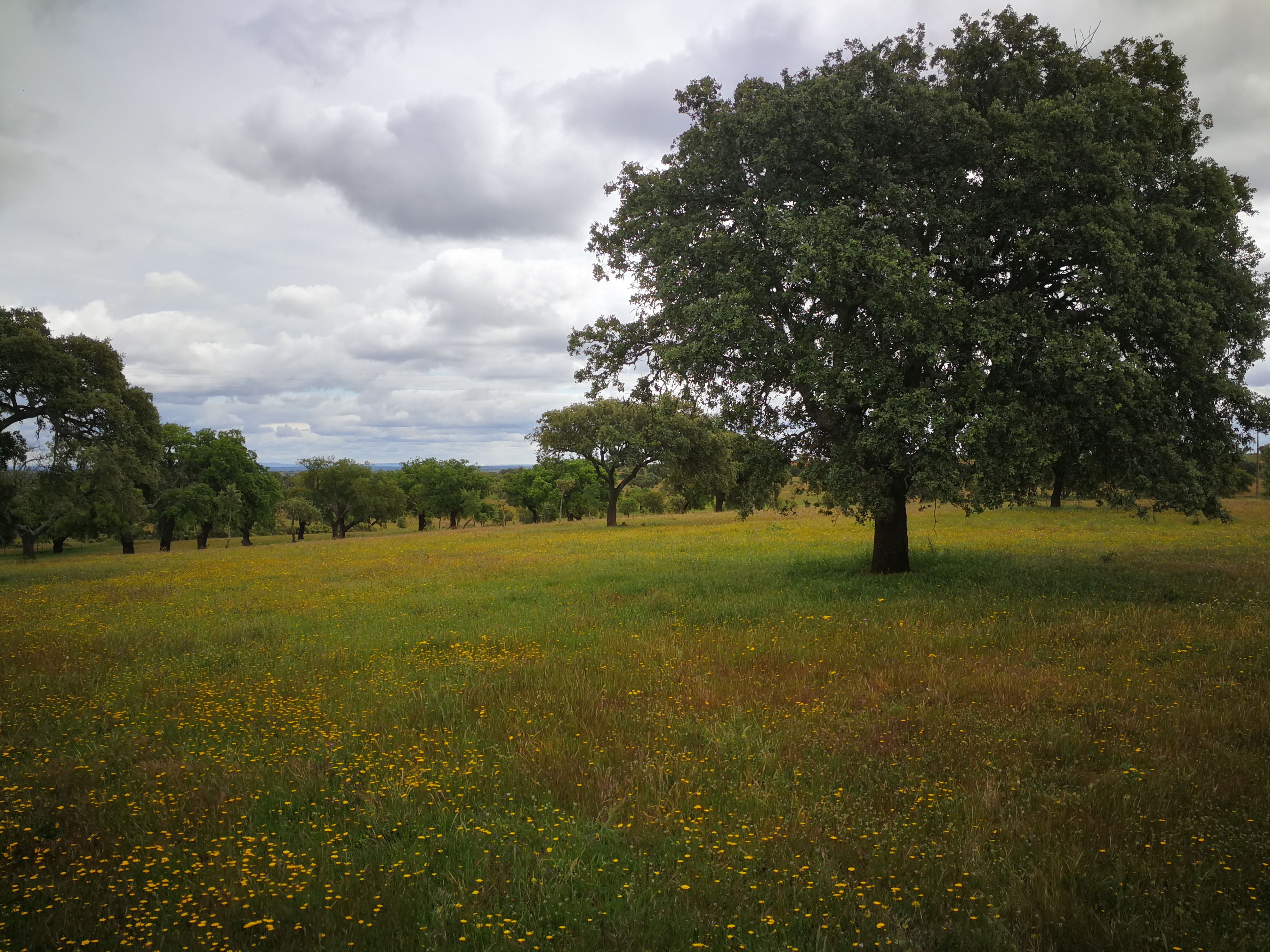
Agroforestry in Montado and Dehesa
technologies_7126 - ប្រទេសព័រទុយហ្គាល់
ពិនិត្យមើលគ្រប់ផ្នែក
ពង្រីកមើលទាំងអស់ បង្រួមទាំងអស់1. ព័ត៌មានទូទៅ
1.2 ព័ត៌មានលម្អិតពីបុគ្គលសំខាន់ៗ និងស្ថាប័នដែលចូលរួមក្នុងការវាយតម្លៃ និងចងក្រងឯកសារនៃបច្ចេកទេស
បុគ្គលសំខាន់ម្នាក់ (ច្រើននាក់)
អ្នកជំនាញឯកទេស SLM:
Lourenço Patrícia
AgroInsider
ប្រទេសព័រទុយហ្គាល់
អ្នកជំនាញឯកទេស SLM:
Marques da Silva José Rafael
AgroInsider
ប្រទេសព័រទុយហ្គាល់
អ្នកជំនាញឯកទេស SLM:
Paixão Luís
AgroInsider
ប្រទេសព័រទុយហ្គាល់
ឈ្មោះគម្រោងដែលបានចងក្រងឯកសារ/ វាយតម្លៃលើបច្ចេកទេស (បើទាក់ទង)
Land Use Based Mitigation for Resilient Climate Pathways (LANDMARC)1.3 លក្ខខណ្ឌទាក់ទងទៅនឹងការប្រើប្រាស់ទិន្នន័យដែលបានចងក្រងតាមរយៈ វ៉ូខេត
អ្នកចងក្រង និង(បុគ្គលសំខាន់ៗ)យល់ព្រមទទួលយកនូវលក្ខខណ្ឌនានាទាក់ទងទៅនឹងការប្រើប្រាស់ទិន្នន័យដែលបានចងក្រងតាមរយៈវ៉ូខេត:
បាទ/ចា៎
1.4 សេចក្តីប្រកាសស្តីពីចីរភាពនៃការពណ៌នាពីបច្ចេកទេស
តើបច្ចេកទេសដែលបានពណ៌នានេះមានបញ្ហាដែលផ្តោតលើការធ្លាក់ចុះគុណភាពដី, បើដូច្នេះវាមិនអាចត្រូវបានប្រកាសថាជាបច្ចេកទេសនៃការគ្រប់គ្រងប្រកបដោយចីរភាពទេ?
ទេ
2. ការពណ៌នាពីបច្ចេកទេស SLM
2.1 ការពណ៌នាដោយសង្ខេបពីបច្ចេកទេស
និយមន័យបច្ចេកទេស:
The Montado/ Dehesa Agroforestry system contributes to carbon sequestration in Spain and Portugal. The SmartAG app helps in monitoring and management of these systems, providing data available to farmers, producers, and stakeholders.
2.2 ការពណ៌នាលម្អិតពីបច្ចេកទេស
ការពណ៌នា:
The SmartAG model is mainly applied in the Montado (Portugal) and Dehesa (Spain) agroforestry systems which serve as a biodiversity oasis in the
Mediterranean region. They are currently being heavily impacted by climate change.
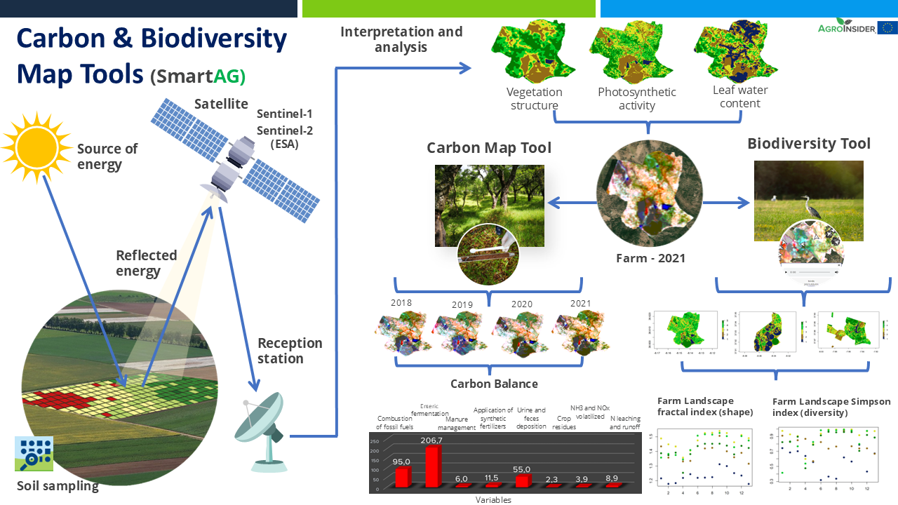
It contributes to achieving carbon sequestration potential. The SmartAG model is also applied in agriculture systems in Portugal, Spain, Greece, The Netherlands, Indonesia and Ukraine. Nevertheless, it can be applied in any part of the world. The SmartAG app provides accurate Agricultural Climate Services on a large-scale, available to farmers, producers, and stakeholders. The model analyzes agronomic anomalies to reduce CO2 emissions and promote CO2 sequestration in the soil, via remote sensing. Additionally, it seeks to remotely analyze farms by evaluating the spatiotemporal dynamics occurring in agroforestry activities for the same purposes.
Through data collection on land use, mapping, remote sensing and in situ data collection, an assessment of the initial state of the farm is carried out, along a carbon balance, to establish a reference scenario (baseline year). Future projections are made, and recommendations formulated.
Users appreciate this methodology because it helps them conserve or increase current carbon stocks, potentially creating a new source of income through the sale
of carbon credits. SmartAG is a highly user-friendly app which records georeferenced evidence of existing conditions and activities. It facilitates a transparent and participatory process in agroforestry ecosystem management.
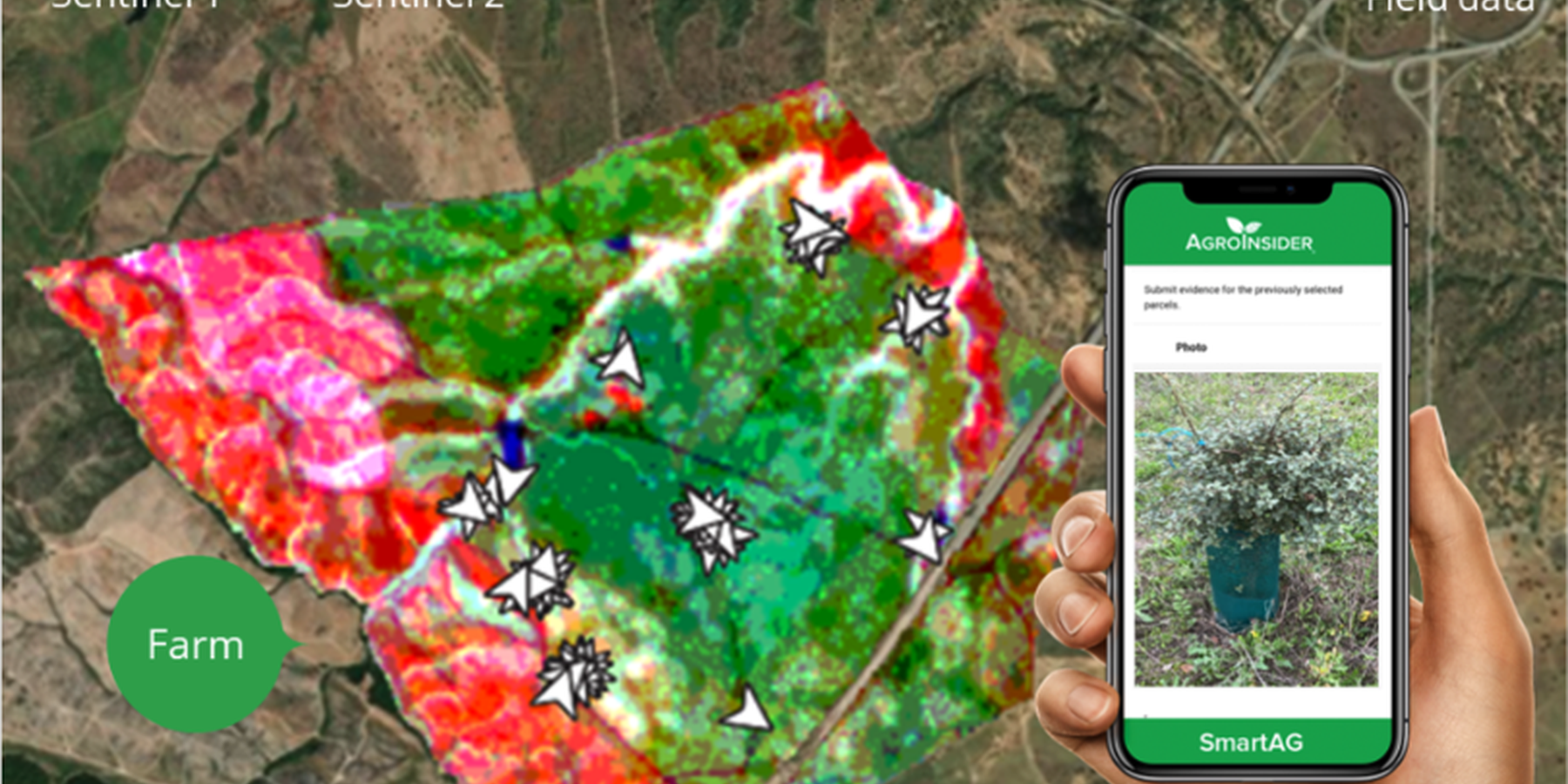
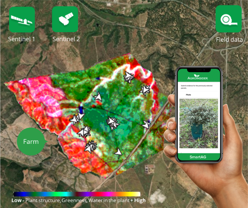
SmartAG automatically processes data from Sentinel-1 and Sentinel-2 data, and LST data for thermo-climatic zoning. These data: i) allow monitoring, reporting and verification of farms; ii) provide machine learning capabilities in agroforestry and environmental data.
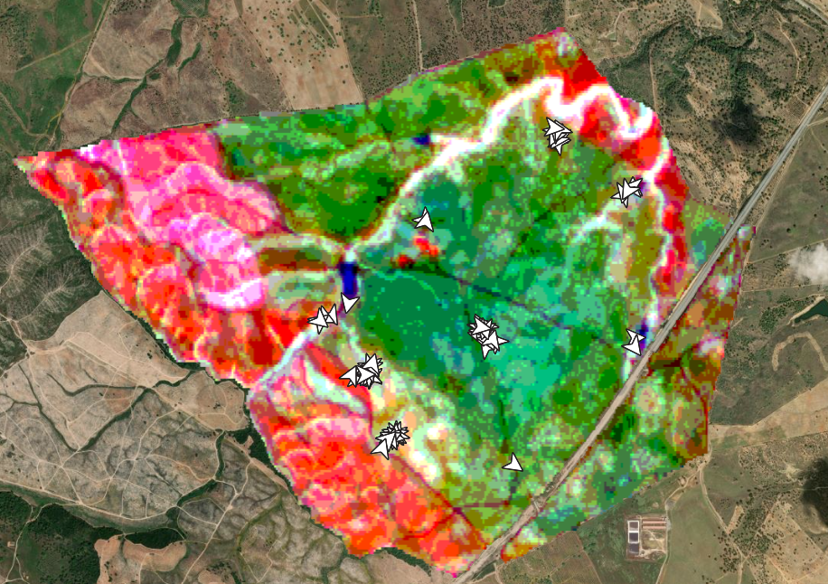
Based on Sentinel data, spectral vegetation indices are calculated to identify: i) crop anomalies related to soil-water-plant; ii) management zones to define different land uses, the selection of sampling locations and sensor installation sites, water sampling locations, and identification of species for biodiversity quantification.
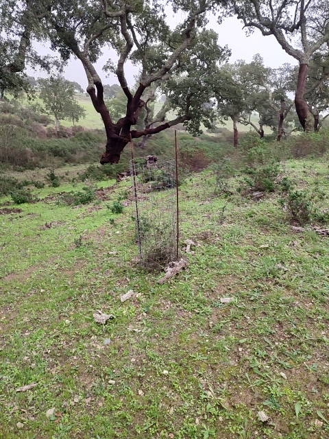
The Montado/Dehesa is a slow-developing and very complex agroforestry system meaning that differences will be observable only at the end of a year or longer. In addition, it is a highly stratified system, consisting of a complex arboreal structure with trees of different ages, shrubs, and herbaceous vegetation. Given the limitations of Sentinel-1 and Sentinel-2 satellites it is essential to record georeferenced evidence of these. Using SmartAG app developed by AgroInsider allows the collection of georeferenced evidence (e.g., photos, audios, and videos) of
the vegetation structures, as well as documenting evidence of processes occurring such as ecosystem services and biodiversity. Georeferenced evidence is automatically uploaded into the system.
2.3 រូបភាពនៃបច្ចេកទេស
វិចិត្រសាលប្រព័ន្ធផ្សព្វផ្សាយ
2.4 វីដេអូនៃបច្ចេកទេស
ការពណ៌នាសង្ខេប:
https://www.youtube.com/watch?v=zxKjnAAkSI0
កាលបរិច្ឆេទ:
16/06/2023
ទីតាំង:
Évora, Portugal
ឈ្មោះអ្នកថតវីឌីអូ:
Filipa Santos
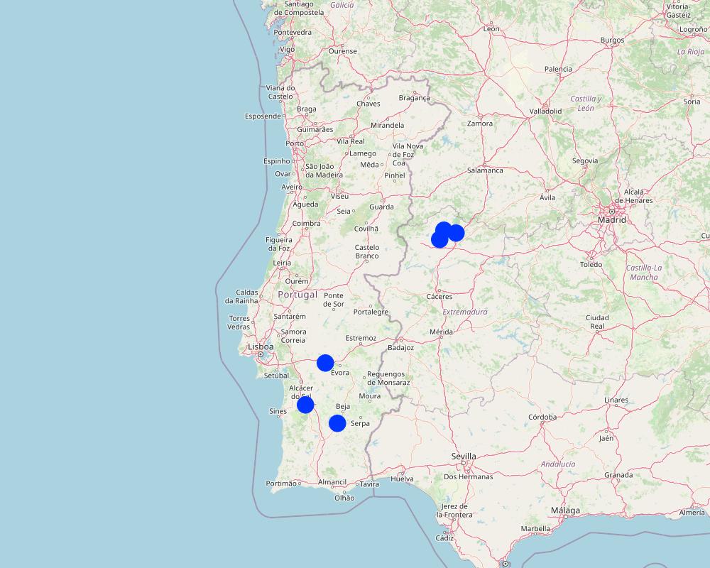
2.5 ប្រទេស/តំបន់/ទីតាំងកន្លែង ដែលបច្ចេកទេសត្រូវបានអនុវត្ត និងបានគ្រប់ដណ្តប់ដោយការវាយតម្លៃនេះ
ប្រទេស:
ប្រទេសព័រទុយហ្គាល់
តំបន់/រដ្ឋ/ខេត្ត:
Alentejo
បញ្ជាក់ពីការសាយភាយនៃបច្ចេកទេស:
- ត្រូវបានផ្សព្វផ្សាយត្រឹមតំបន់មួយ
ប្រសិនបើបច្ចេកទេសត្រូវបានសាយភាយពាសពេញតំបន់ណាមួយ បញ្ជាក់ទំហំផ្ទៃដីអនុវត្តន៍ (គិតជា គ.ម2):
100000,0
តើបច្ចេកទេស (មួយ ឬច្រើន) ទាំងនោះស្ថិតនៅក្នុងតំបន់ការពារជាអចិន្ត្រៃយ៍ណាមួយដែរឬទេ?
បាទ/ចា៎
បើបាទ/ច៎ា សូមបញ្ជាក់:
Montado and Dehesa constitute a Very High Nature Value agroforestry system which is under protection.
Map
×2.6 កាលបរិច្ឆេទនៃការអនុវត្ត
បង្ហាញឆ្នាំនៃការចុះអនុវត្ត:
2023
2.7 ការណែនាំពីបច្ចេកទេស
សូមបញ្ជាក់តើបច្ចេកទេសត្រូវបានណែនាំឱ្យអនុវត្តដោយរបៀបណា:
- ពេលកំពុងពិសោធន៍
មតិយោបល់ (ប្រភេទនៃគម្រោង ។ល។):
In 2023 AgroInsider started the implementation of the LMT and SmartAG monitoring in Agroforestry system case studies in Montado, in Portugal, and Dehesa, in Spain.
3. ចំណាត់ថ្នាក់នៃបច្ចេកទេស SLM
3.1 គោលបំណងចម្បង (១ ឬច្រើន) នៃបច្ចេកទេសនេះ
- កាត់បន្ថយ, បង្ការ, ស្តារឡើងវិញនូវការធ្លាក់ចុះគុណភាពដី
- អភិរក្សប្រព័ន្ធអេកូឡូស៊ី
- ការពារតំបន់ទីជម្រាល/តំបន់ខ្សែទឹកខាងក្រោមបញ្ចូលជាមួយបច្ចេកទេសផ្សេងទៀត
- អភិរក្ស/ធ្វើឱ្យប្រសើរឡើងជីវចម្រុះ
- កាត់បន្ថយការប្រែប្រួលអាកាសធាតុ និងផលប៉ះពាល់របស់វា
3.2 ប្រភេទដីប្រើប្រាស់មួយប្រភេទ (ច្រើនប្រភេទ) ដែលបានអនុវត្តបច្ចេកទេស
ដីប្រើប្រាស់ចម្រុះនៅលើដីតែមួយ:
បាទ/ចា៎
បញ្ជាក់ពីប្រភេទដីច្រើនប្រភេទ (ដីដាំដំណាំ/ដីចិញ្ចឹមសត្វ/ដីព្រៃឈើ):
- ដាំដំណាំ ចិញ្ចឹមសត្វ និងឈើ

ដីសម្រាប់ចិញ្ចឹមសត្វ
វាលស្មៅធំៗ:
- បែងចែកវាលស្មៅជាប្លុក
- Transhumant pastoralism
ដីវាលស្មៅតូចៗ/ ផលិតកម្មចំណី:
- បង្កើនវាលស្មៅ
ប្រភេទសត្វ:
- សត្វពាហនៈ - សត្វចិញ្ចឹមមិនយកទឹកដោះតែសម្រាប់យកសាច់
- បសុបក្សី
- សត្វចៀម
តើជាការអនុវត្តការគ្រប់គ្រងដែលរួមបញ្ចូលការដាំដំណាំ និងចិញ្ចឹមសត្វដែរឬទេ?
ទេ
ផលិតផល និងសេវាកម្ម:
- សាច់
- ទឹកដោះគោ
- រោមសត្វ
ប្រភេទពូជ:
សត្វចៀម
ចំនួន:
40
ប្រភេទពូជ:
cattle - dairy and beef (e.g. zebu)
ចំនួន:
40

ដីព្រៃ/ដីដាំដើមឈើ
- ព្រៃ (ពាក់កណ្តាល) ធម្មជាតិ/ ដីព្រៃ
ព្រៃ (ពាក់កណ្តាល) ធម្មជាតិ / ដីព្រៃ៖ បញ្ជាក់ប្រភេទនៃការគ្រប់គ្រង:
- ឈើងាប់ៗ/ មែកដែលបាក់
- Mediterranean Agroforestry System (Montado/Dehesa)
- cork holm, cork oak
តើប្រភេទឈើខាងលើជាប្រភេទឈើក្នុងព្រៃល្បោះ ឬស្រោង?
- ព្រៃស្រោង
ផលិតផល និងសេវាកម្ម:
- ផ្លែឈើ និងគ្រាប់ធញ្ញជាតិ
- ការអភិរក្ស/ការការពារធម្មជាតិ
- cork
3.3 បន្ទាប់ពីអនុវត្តបច្ចេកទេស តើដីប្រើប្រាស់មានការប្រែប្រួលដែររឺទេ?
បន្ទាប់ពីអនុវត្តបច្ចេកទេស តើដីប្រើប្រាស់មានការប្រែប្រួលដែររឺទេ?
- ទេ (បន្តទៅសំណួរ 3.4)
3.4 ការផ្គត់ផ្គង់ទឹក
ការផ្គត់ផ្គង់ទឹកនៅកន្លែងអនុវត្តបច្ចេកទេស:
- ទឹកភ្លៀង
3.5 ក្រុម SLM ដែលបច្ចេកទេសស្ថិតនៅក្នុង
- កសិរុក្ខកម្ម
- កសិរុក្ខកម្ម (pastoralism) និងការគ្រប់គ្រងដីសម្រាប់ចិញ្ចឹមសត្វ
- ធ្វើឱ្យប្រសើរឡើងគម្របដី/ ដំណាំគម្របដី
3.6 វិធានការ SLM ដែលបញ្ចូលនូវបច្ចេកទេស

វិធានការរុក្ខជាតិ
- V1: ឈើធំៗ និងដើមឈើតូចៗ
- V2: ស្មៅនិងរុក្ខជាតិៗដែលដុះមានអាយុមិនលើសពី 2ឆ្នាំ

វិធានការគ្រប់គ្រង
- M1: ការផ្លាស់ប្តូរប្រភេទដីប្រើប្រាស់
- M2: ការផ្លាស់ប្តូរការគ្រប់គ្រង/ កម្រិតអាំងតង់ស៊ីតេ
3.7 កំណត់ប្រភេទនៃការធ្លាក់ចុះគុណភាពដីសំខាន់ៗដែលបច្ចេកទេសនេះបានដោះស្រាយ

ការធ្លាក់ចុះសារធាតុគីមីក្នុងដី
- Cn: ការថយចុះជីជាតិ និងកាត់បន្ថយបរិមាណសារធាតុសរីរាង្គ (មិនកើតឡើងដោយការហូរច្រោះទេ)
- Ca: អាស៊ីតកម្ម

ការបាត់បង់រូបសាស្ត្រនៃដី
- Pc: ការហាប់ណែន
3.8 ការពារ កាត់បន្ថយ ឬស្តារឡើងវិញនៃការធ្លាក់ចុះគុណភាពដី
បញ្ជាក់ពីគោលដៅរបស់បច្ចេកទេស ដែលផ្តោតទៅការធ្លាក់ចុះគុណភាពដី:
- ការការពារការធ្លាក់ចុះគុណភាពដី
- ការកាត់បន្ថយការធ្លាក់ចុះគុណភាពដី
4. បច្ចេកទេសជាក់លាក់ សកម្មភាពអនុវត្ត ធាតុចូល និងថ្លៃដើម
4.1 គំនូសបច្ចេកទេសនៃបច្ចេកទេសនេះ
លក្ខណៈពិសេសនៃបច្ចេកទេស (ទាក់ទងនឺងគំនូរបច្ចេកទេស):
The LMT will be implemented on a farm with montado/dehesa (minimum area of 100 ha). Satellite data is used to characterize land use. After identifying the montado/dehesa area, field sampling is conducted. These data, along with satellite imagery, will be used to calculate the total CO2eq stock (above and below ground biomass) and estimate CO2eq sequestration. Farmers are encouraged to enhance LMT effectiveness, notably by engaging in ecosystem-value activities such as avoiding soil disturbance to preserve soil organic matter, increasing tree density, and maintaining water mirrors. Farmers will record georeferenced evidence of improvement activities and existing biodiversity in the montado and in other areas of the farm using the SmartAG developed by AgroInsider. This app will allow to monitor, report and verify carbon stocks through weekly alert reports, enabling the identification of carbon anomalies/losses over time and space.
ឈ្មោះអ្នកនិពន្ធ:
Patrícia Lourenço
កាលបរិច្ឆេទ:
23/04/2024
4.2 ព័ត៌មានទូទៅដែលពាក់ព័ន្ធនឹងការគណនាធាតុចូល និងថ្លៃដើម
កំណត់របៀបនៃការគណនាថ្លៃដើម និងធាតុចូល:
- ក្នុងតំបន់អនុវត្តបច្ចេកទេស
កំណត់ទំហំ និងឯកត្តាផ្ទៃដី:
100 ha
ផ្សេងៗ/ រូបិយប័ណ្ណជាតិ (បញ្ជាក់):
Euro (€)
កំណត់ថ្លៃឈ្នួលជាមធ្យមនៃការជួលកម្លាំងពលកម្មក្នុងមួយថ្ងៃ:
3590 €
4.3 សកម្មភាពបង្កើត
| សកម្មភាព | រយៈពេល (រដូវកាល) | |
|---|---|---|
| 1. | Select a farm with montado/dehesa (minimum area of 100 ha) | In the baseline year |
| 2. | Characterization of the land use using satellite data in the baseline year | In the baseline year |
| 3. | Field sampling in the montado/dehesa area | In the baseline year |
| 4. | Field data along with satellite imagery will be used to calculate the total CO2eq stock (above and below ground biomass) and estimate CO2eq sequestration | In the baseline year |
| 5. | Farmers are encouraged to enhance LMT effectiveness, notably by engaging in ecosystem-value activities such as avoiding soil disturbance to preserve soil organic matter, increasing tree density, and maintaining water mirrors | In the baseline year |
| 6. | Farmers will record georeferenced evidence of improvement activities and existing biodiversity in the montado and in other areas of the farm using the SmartAG developed by AgroInsider | Whenever farmers go to the field |
| 7. | After calculating the CO2eq stock and CO2eq sequestration estimates for the baseline year, SmartAG will allow to monitor, report and verify (MRV) carbon stocks through weekly alert reports. The MRV will enable the identification of carbon anomalies/losses over time and space | Weekly |
4.4 ថ្លៃដើម និងធាតុចូលដែលត្រូវការសម្រាប់ការបង្កើតបច្ចេកទេស
| បញ្ជាក់ពីធាតុចូល | ឯកតា | បរិមាណ | ថ្លៃដើមក្នុងមួយឯកតា | ថ្លៃធាតុចូលសរុប | % នៃថ្លៃដើមដែលចំណាយដោយអ្នកប្រើប្រាស់ដី | |
|---|---|---|---|---|---|---|
| កម្លាំងពលកម្ម | Data preprocessing before heading to the field | Hour | 4,0 | 20,0 | 80,0 | 0,0 |
| កម្លាំងពលកម្ម | Field data collection | Hour | 24,0 | 20,0 | 480,0 | 0,0 |
| កម្លាំងពលកម្ម | Post-processing of field and satellite data | Hour | 4,0 | 20,0 | 80,0 | 0,0 |
| កម្លាំងពលកម្ម | Improvement suggestions | Hour | 8,0 | 20,0 | 160,0 | 0,0 |
| កម្លាំងពលកម្ម | Emission estimates | Hour | 40,0 | 20,0 | 800,0 | 0,0 |
| សម្ភារៈ | Car renting | Day | 1,0 | 60,0 | 60,0 | 0,0 |
| សម្ភារៈ | Fuel | Km | 350,0 | 0,4 | 140,0 | 0,0 |
| សម្ភារៈដាំដុះ | Soil sampling | Samples | 3,0 | 70,0 | 210,0 | 0,0 |
| ផ្សេងៗ | 1,0 | |||||
| ថ្លៃដើមសរុបក្នុងការបង្កើតបច្ចេកទេស | 2010,0 | |||||
| ថ្លៃដើមសរុបក្នុងការបង្កើតបច្ចេកទេសគិតជាដុល្លារ | 2010,0 | |||||
ប្រសិនបើអ្នកប្រើប្រាស់ដីមិនមានថ្លៃដើម 100% សូមបញ្ជាក់ថានរណាដែលចំណាយថ្លៃដើមដែលនៅសល់:
The costs are covered by AgroInsider
មតិយោបល់:
This value varies depending on the distance from AgroInsider's headquarters to the farm, the farm's area, and carbon-emitting farm activities (i.e., agricultural activities).
4.5 សកម្មភាពថែទាំ
| សកម្មភាព | ពេលវេលា/ ភាពញឹកញាប់ | |
|---|---|---|
| 1. | Calculate the total CO2eq stock (above and below ground biomass) and estimate CO2eq sequestration | In the baseline year |
| 2. | MRV carbon stocks | Weekly |
| 3. | Record georeferenced evidence | Whenever farmers go to the field |
4.7 កត្តាសំខាន់បំផុតដែលមានឥទ្ធិពលដល់ការចំណាយ
ពណ៌នាពីកត្តាប៉ះពាល់ចម្បងៗទៅលើថ្លៃដើម:
Human resources, farm area, and the quantity of carbon-emitting farm activities (i.e., agricultural activities).
5. លក្ខណៈបរិស្ថានធម្មជាតិ និងមនុស្ស
5.1 អាកាសធាតុ
បរិមាណទឹកភ្លៀងប្រចាំឆ្នាំ
- < 250 មម
- 251-500 មម
- 501-750 មម
- 751-1,000 មម
- 1,001-1,500 មម
- 1,501-2,000 មម
- 2,001-3,000 មម
- 3,001-4,000 មម
- > 4,000 មម
លក្ខណៈពិសេស/ មតិយោបល់លើរដូវភ្លៀង:
Montado/Dehesa is influenced by the Mediterranean climate, characterized by a great variability in precipitation and temperature in each year and between years, presenting a hot summer lasting more than four months, associated with a high irregularity in precipitation, both inter- and intra-annually. In this climate, natural droughts are recurrent.
តំបន់កសិអាកាសធាតុ
- មានភ្លៀងតិចតួច
More recent data for the agricultural years 2015/2016, 2016/2017, and 2017/2018 report values for cumulative precipitation for the Évora region (Alentejo) of 547 mm, 421 mm, and 612 mm, respectively. However, in the same region, in the 2018/2019 crop year, there was only 315 mm of precipitation, while in the following year, this value already reached 627 mm.
It is common in the Alentejo region to have several days with temperatures above 40 ◦C in summer and with minimum temperatures below 0 ◦C in winter. In the Estremadura region, the average minimum temperature recorded was 3.4 ◦C, and the average maximum temperature was 35.6 ◦C.
5.2 សណ្ឋានដី
ជម្រាលជាមធ្យម:
- រាបស្មើ (0-2%)
- ជម្រាលតិចតួច (3-5%)
- មធ្យម (6-10%)
- ជម្រាលខ្ពស់បន្តិច (11-15%)
- ទីទួល (16-30%)
- ទីទួលចោត (31-60%)
- ទីទួលចោតខ្លាំង (>60%)
ទម្រង់ដី:
- ខ្ពង់រាប
- កំពូលភ្នំ
- ជម្រាលភ្នំ
- ជម្រាលទួល
- ជម្រាលជើងភ្នំ
- បាតជ្រលងភ្នំ
តំបន់តាមរយៈកម្ពស់ :
- 0-100 ម
- 101-500 ម
- 501-1,000 ម
- 1,001-1,500 ម
- 1,501-2,000 ម
- 2,001-2,500 ម
- 2,501-3,000 ម
- 3,001-4,000 ម
- > 4,000 ម
បញ្ជាក់ថាតើបច្ចេកទេសនេះត្រូវបានអនុវត្តន៍នៅក្នុង:
- មិនពាក់ព័ន្ធទាំងអស់
5.3 ដី
ជម្រៅដីជាមធ្យម:
- រាក់ខ្លាំង (0-20 សម)
- រាក់ (21-50 សម)
- មធ្យម (51-80 សម)
- ជ្រៅ (81-120 សម)
- ជ្រៅខ្លាំង (> 120 សម)
វាយនភាពដី (ស្រទាប់លើ):
- គ្រើម/ មានពន្លឺ (ខ្សាច់)
- មធ្យម (ល្បាយ, ល្បាប់)
វាយនភាពដី (> 20 សម ស្រទាប់ក្នុង):
- គ្រើម/ មានពន្លឺ (ខ្សាច់)
- មធ្យម (ល្បាយ, ល្បាប់)
សារធាតុសរីរាង្គនៅស្រទាប់ដីខាងលើ:
- មធ្យម (1-3%)
5.4 ទឹកដែលអាចទាញមកប្រើប្រាស់បាន និងគុណភាពទឹក
ទឹកលើដីដែលអាចទាញយកប្រើប្រាស់បាន:
មិនមាន/ គ្មាន
គុណភាពទឹក (មិនបានធ្វើប្រត្តិកម្ម):
ទឹកសម្រាប់តែការធ្វើកសិកម្ម (ស្រោចស្រព)
តើមានបញ្ហាភាពទឹកប្រៃហូរចូលមកដែរឬទេ?
ទេ
តើទឹកជំនន់កំពុងកើតមាននៅតំបន់នេះដែររឺទេ?
ទេ
5.5 ជីវៈចម្រុះ
ភាពសម្បូរបែបនៃប្រភេទ:
- កម្រិតមធ្យម
ភាពសម្បូរបែបនៃទីជម្រក:
- ខ្ពស់
មតិយោបល់ និងលក្ខណៈពិសេសផ្សេងទៀតលើជីវចម្រុះ:
The Agroforestry system Montado, in Portugal, and Dehesa, in Spain, is a High Nature Value system characterized by a high complexity because of the interactions between climate, soil, pasture (natural pastures, fertilized natural pastures, and sown biodiverse permanent pastures rich in legumes), trees (e.g., pure or mix stands of cork oak, holm oak, stone pine), and animals (e.g., sheep, pigs, cows, goats). Montado/Dehesa is one of the most prominent and best preserved low-intensity farming systems in Europe. The integration of traditional land-use and biodiversity conservation that is characteristic of this system is an exemplar for the wise management of the countryside.
5.6 លក្ខណៈនៃអ្នកប្រើប្រាស់ដីដែលអនុវត្តបច្ចេកទេស
នៅមួយកន្លែង ឬពនេចរ :
- នៅមួយកន្លែង
ទីផ្សារនៃប្រព័ន្ធផលិតកម្ម:
- ពាក់កណ្តាលពាណិជ្ជកម្ម (ផ្គត់ផ្គង់ខ្លួនឯង/ ពាណិជ្ជកម្ម)
ចំណូលក្រៅកសិកម្ម:
- 10-50% នៃចំណូល
កម្រិតជីវភាព:
- មធ្យម
ឯកជន ឬក្រុម:
- ធ្វើខ្លួនឯង/ គ្រួសារ
- សហករ
កម្រិតប្រើប្រាស់គ្រឿងយន្ត:
- គ្រឿងយន្ត/ ម៉ាស៊ីន
យេនឌ័រ:
- ស្ត្រី
- បុរស
អាយុរបស់អ្នកប្រើប្រាស់ដី:
- វ័យកណ្តាល
- មនុស្សចាស់
5.7 ទំហំផ្ទៃដីជាមធ្យមនៃដីប្រើប្រាស់ដោយអ្នកប្រើប្រាស់ដី ក្នុងការអនុវត្តបច្ចេកទេស
- < 0.5 ហិកតា
- 0.5-1 ហិកតា
- 1-2 ហិកតា
- 2-5 ហិកតា
- 5-15 ហិកតា
- 15-50 ហិកតា
- 50-100 ហិកតា
- 100-500 ហិកតា
- 500-1,000 ហិកតា
- 1,000-10,000 ហិកតា
- > 10,000 ហិកតា
តើផ្ទៃដីនេះចាត់ទុកជាទំហំកម្រិតណាដែរ ខ្នាតតូច មធ្យម ឬខ្នាតធំ (ធៀបនឹងបរិបទតំបន់)?
- ខ្នាតធំ
5.8 ភាពជាម្ចាស់ដី កម្មសិទ្ធប្រើប្រាស់ដី និងកម្មសិទ្ធប្រើប្រាស់ទឹក
ភាពជាម្ចាស់ដី:
- ឯកជន មានកម្មសិទ្ធ
កម្មសិទ្ធិប្រើប្រាស់ដី:
- ឯកជន
កម្មសិទ្ធប្រើប្រាស់ទឹក:
- ឯកជន
តើកម្មសិទ្ធប្រើប្រាស់ដី គឺផ្អែកលើប្រព័ន្ធច្បាប់បែបបុរាណ?
បាទ/ចា៎
5.9 ការប្រើប្រាស់សេវាកម្ម និងហេដ្ឋារចនាសម្ព័ន្ធ
សុខភាព:
- មិនល្អ
- មធ្យម
- ល្អ
ការអប់រំ:
- មិនល្អ
- មធ្យម
- ល្អ
ជំនួយបច្ចេកទេស:
- មិនល្អ
- មធ្យម
- ល្អ
ការងារ (ឧ. ការងារក្រៅកសិដ្ឋាន):
- មិនល្អ
- មធ្យម
- ល្អ
ទីផ្សារ:
- មិនល្អ
- មធ្យម
- ល្អ
ថាមពល:
- មិនល្អ
- មធ្យម
- ល្អ
ផ្លូវ និងការដឹកជញ្ជូន:
- មិនល្អ
- មធ្យម
- ល្អ
ទឹកផឹក និងអនាម័យ:
- មិនល្អ
- មធ្យម
- ល្អ
សេវាកម្មហិរញ្ញវត្ថុ:
- មិនល្អ
- មធ្យម
- ល្អ
6. ផលប៉ះពាល់ និងការសន្និដ្ឋាន
6.1 ផលប៉ះពាល់ក្នុងបរិវេណអនុវត្តបច្ចេកទេសដែលកើតមាន
ផលប៉ះពាល់លើសេដ្ឋកិច្ចសង្គម
ផលិតផល
គុណភាពព្រៃឈើ/ដីព្រៃ
មតិយោបល់/ ការបញ្ជាក់:
Conservation and preservation of the Montado and Dehesa.
Estimated
ការគ្រប់គ្រងដី
មតិយោបល់/ ការបញ្ជាក់:
Conservation and preservation of the Montado and Dehesa.
Estimated
ចំណូល និងថ្លៃដើម
ចំណូលក្នុងកសិដ្ឋាន
មតិយោបល់/ ការបញ្ជាក់:
Selling carbon credits in the voluntary market
Estimated
ផលប៉ះពាល់ទៅលើអេកូឡូស៊ី
ជីវចម្រុះ៖ ដំណាំ, សត្វ
ដំណាំគម្រប
មតិយោបល់/ ការបញ្ជាក់:
MRV and Implementation of improvements in Montado/Dehesa.
Estimated
ជីវម៉ាស/ កាបូនលើដី
មតិយោបល់/ ការបញ្ជាក់:
MRV, Recording evidence and Implementation of improvements in Montado/Dehesa.
Measured
ភាពសម្បូរបែបនៃរុក្ខជាតិ
មតិយោបល់/ ការបញ្ជាក់:
MRV, Recording evidence of reforestation of young growth and Implementation of improvements in Montado/Dehesa.
Estimated
ភាពសម្បូរបែបនៃទីជំរក
មតិយោបល់/ ការបញ្ជាក់:
MRV, Recording evidence and Implementation of improvements in Montado/Dehesa.
Estimated
ការកាត់បន្ថយហានិភ័យនៃគ្រោះមហន្តរាយ និងគ្រោះអាកាសធាតុ
ការបំភាយនៃកាបូន និងឧស្ម័នផ្ទះកញ្ចក់
មតិយោបល់/ ការបញ្ជាក់:
MRV, Recording evidence, Calculation of emissions and Implementation of improvements in Montado/Dehesa.
Measured
ហានិភ័យនៃភ្លើងឆេះព្រៃ
មតិយោបល់/ ការបញ្ជាក់:
MRV and Implementation of improvements in Montado/Dehesa. Estimated
6.2 ផលប៉ះពាល់ក្រៅបរិវេណអនុវត្តបច្ចេកទេសដែលកើតមាន
វាយតម្លៃផលប៉ះពាល់ក្រៅបរិវេណអនុវត្តបច្ចេកទេស (វាស់វែង):
None
6.3 ភាពប្រឈម និងភាពរួសនៃបច្ចេកទេសទៅនឹងការប្រែប្រួលអាកាសធាតុ និងគ្រោះអាកាសធាតុ/ គ្រោះមហន្តរាយ (ដែលដឹងដោយអ្នកប្រើប្រាស់ដី)
ការប្រែប្រួលអាកាសធាតុ
ការប្រែប្រួលអាកាសធាតុ
| រដូវកាល | កើនឡើង ឬថយចុះ | លក្ខណៈឆ្លើយតបនៃបច្ចេកទេសទៅនឹងការប្រែប្រួលអាកាសធាតុ | |
|---|---|---|---|
| សីតុណ្ហភាពប្រចាំឆ្នាំ | កើនឡើង | មធ្យម | |
| បរិមាណទឹកភ្លៀងប្រចាំឆ្នាំ | ថយចុះ | មធ្យម |
គ្រោះអាកាសធាតុ (មហន្តរាយ)
គ្រោះមហន្តរាយអាកាសធាតុ
| លក្ខណៈឆ្លើយតបនៃបច្ចេកទេសទៅនឹងការប្រែប្រួលអាកាសធាតុ | |
|---|---|
| រលកកម្តៅ | មធ្យម |
| រាំងស្ងួត | មធ្យម |
| ភ្លើងឆេះព្រៃ | មធ្យម |
6.4 ការវិភាគថ្លៃដើម និងអត្ថប្រយោជន៍
តើផលចំណេញ និងថ្លៃដើមត្រូវបានប្រៀបធៀបគ្នាយ៉ាងដូចម្តេច (ទស្សនៈរបស់អ្នកប្រើប្រាស់ដី)?
រយៈពេលខ្លី:
វិជ្ជមានតិចតួច
រយៈពេលវែង:
វិជ្ជមាន
តើផលចំណេញ និងការថែទាំ/ ជួសជុលត្រូវបានប្រៀបធៀបគ្នាយ៉ាងដូចម្តេច (ទស្សនៈរបស់អ្នកប្រើប្រាស់ដី)?
រយៈពេលខ្លី:
វិជ្ជមាន
រយៈពេលវែង:
វិជ្ជមានតិចតួច
6.5 ការទទួលយកបច្ចេកទេស
- > 50%
ក្នុងចំណោមគ្រួសារទាំងអស់ដែលបានអនុវត្តបច្ចេកទេស តើមានប៉ុន្មានគ្រួសារដែលចង់ធ្វើដោយខ្លួនឯង ដោយមិនទទួលបានសម្ភារៈលើកទឹកចិត្ត/ប្រាក់ឧបត្ថម្ភ?:
- 51-90%
6.6 ការបន្សុំា
តើថ្មីៗនេះ បច្ចេកទេសនេះត្រូវបានកែតម្រូវដើម្បីបន្ស៊ាំទៅនឹងស្ថានភាពប្រែប្រួលដែរឬទេ?
ទេ
6.7 ភាពខ្លាំង/ គុណសម្បត្តិ/ ឱកាសនៃបច្ចេកទេស
| ភាពខ្លាំង/ គុណសម្បត្តិ/ ឱកាសនៅកន្លែងរបស់អ្នកប្រើប្រាស់ដី |
|---|
| Desertification combat efforts. |
| Diversifying income sources |
| Montado/dehesa conservation initiatives |
| ភាពខ្លាំង/ គុណសម្បត្តិ/ ឱកាស ទស្សនៈរបស់បុគ្គលសំខាន់ៗ |
|---|
| New income source |
| Montado/dehesa conservation |
| Maintenance and increase of carbon stock. |
6.8 ភាពខ្សោយ/ គុណវិបត្តិ/ ហានិភ័យនៃបច្ចេកទេស និងវិធីសាស្ត្រដោះស្រាយ
| ភាពខ្សោយ/ គុណវិបត្តិ/ ហានិភ័យ ទស្សនៈរបស់អ្នកប្រើប្រាស់ដី | តើបច្ចេកទេសទាំងនោះបានដោះស្រាយបញ្ហាដូចម្តេច? |
|---|---|
| Price of carbon credit in the voluntary market | Selling abroad of Portugal |
| Delay in the implementation of the voluntary carbon market |
| ភាពខ្សោយ/ គុណវិបត្តិ/ ហានិភ័យ ទស្សនៈរបស់អ្នកចងក្រងឬបុគ្គលសំខាន់ៗ | តើបច្ចេកទេសទាំងនោះបានដោះស្រាយបញ្ហាដូចម្តេច? |
|---|---|
| Delay in the implementation of the voluntary carbon market | Selling abroad of Portugal |
| Certified credits before the entry of the new law on the voluntary carbon market by the European Union | Quantify and recertify. |
7. ឯកសារយោង និងវេបសាយ
7.1 វិធីសាស្ត្រ/ ប្រភពនៃព័ត៌មាន
- តាមការចុះទីវាល ការស្រាវជ្រាវនៅទីវាល
One visit per farm
- ការសម្ភាសន៍ជាមួយអ្នកប្រើប្រាស់ដី
4
- ការសម្ភាសន៍ជាមួយអ្នកជំនាញ/ ឯកទេស
1
តើពេលណាដែលទិន្នន័យបានចងក្រង (នៅទីវាល)?
2022
7.2 ឯកសារយោងដែលបានចេញផ្សាយ
ចំណងជើង អ្នកនិពន្ធ ឆ្នាំ ISBN:
Pinto-Correia, T., & Mira Potes, J. (2013). Livro verde dos montados.
មានប្រភពមកពីណា? ថ្លៃដើមប៉ុន្មាន?
https://dspace.uevora.pt/rdpc/bitstream/10174/10116/1/Livro%20Verde%20dos%20Montados_Versao%20online%20%202013.pdf
ចំណងជើង អ្នកនិពន្ធ ឆ្នាំ ISBN:
Lourenço, Patrícia, & Silva, José Rafael Marques (2023). How our portfolio of land-use practices might be adopted at scale in Portugal
មានប្រភពមកពីណា? ថ្លៃដើមប៉ុន្មាន?
https://static1.squarespace.com/static/5f7b27859c352b2444f4cbd9/t/64a5440ac47212047978bc68/1688552460748/Portugal.pdf
ការតភ្ជាប់ និងម៉ូឌុល
ពង្រីកមើលទាំងអស់ បង្រួមទាំងអស់ការតភ្ជាប់
គ្មានការតភ្ជាប់
ម៉ូឌុល
គ្មានម៉ូឌុល