E-Prakriti - An Approach Towards GIS Based Planning For Natural Farming [ອິນເດຍ]
- ການສ້າງ:
- ປັບປູງ:
- ຜູ້ສັງລວມຂໍ້ມູນ: Santosh Gupta
- ບັນນາທິການ: Noel Templer, Stephanie Katsir, Tabitha Nekesa, Ahmadou Gaye, Siagbé Golli
- ຜູ້ທົບທວນຄືນ: Rima Mekdaschi Studer, Udo Höggel, Joana Eichenberger, Sally Bunning
E-Prakriti
approaches_6726 - ອິນເດຍ
ເບິ່ງພາກສ່ວນ
ຂະຫຍາຍທັງໝົດ ຍຸບທັງໝົດ1. ຂໍ້ມູນທົ່ວໄປ
1.2 ລາຍລະອຽດ ການຕິດຕໍ່ ຂອງບຸກຄົນທີ່ຊັບພະຍາກອນ ແລະ ສະຖາບັນ ການມີສ່ວນຮ່ວມ ໃນການປະເມີນຜົນ ແລະ ເອກະສານ ຂອງວິທີທາງ
ຊື່ຂອງໂຄງການ ທີ່ອໍານວຍຄວາມສະດວກ ໃນການສ້າງເອກກະສານ ຫຼື ປະເມີນດ້ານແນວທາງ (ຖ້າກ່ຽວຂ້ອງ)
Soil protection and rehabilitation for food security (ProSo(i)l)ຊື່ຂອງ ສະຖາບັນການຈັດຕັ້ງ ທີ່ອໍານວຍຄວາມສະດວກ ໃນການສ້າງເອກກະສານ ຫຼື ປະເມີນແນວທາງ (ຖ້າກ່ຽວຂ້ອງ)
Deutsche Gesellschaft für Internationale Zusammenarbeit (GIZ)ຊື່ຂອງ ສະຖາບັນການຈັດຕັ້ງ ທີ່ອໍານວຍຄວາມສະດວກ ໃນການສ້າງເອກກະສານ ຫຼື ປະເມີນແນວທາງ (ຖ້າກ່ຽວຂ້ອງ)
Alliance Bioversity and International Center for Tropical Agriculture (Alliance Bioversity-CIAT) - ເຄັນຢາຊື່ຂອງ ສະຖາບັນການຈັດຕັ້ງ ທີ່ອໍານວຍຄວາມສະດວກ ໃນການສ້າງເອກກະສານ ຫຼື ປະເມີນແນວທາງ (ຖ້າກ່ຽວຂ້ອງ)
Ecociate Consultants (Ecociate Consultants) - ອິນເດຍ1.3 ເງື່ອນໄຂ ຂອງການນໍາໃຊ້ເອກກະສານຂໍ້ມູນ ຂອງ WOCAT
ຜູ້ສັງລວມ ແລະ ບັນດາຜູ້ຕອບແບບສອບຖາມ ຍອມຮັບໃນເງື່ອນໄຂ ການນໍາໃຊ້ຂໍ້ມູນເອກະສານ ທີ່ສ້າງຂື້ນ ໂດຍຜ່ານ ອົງການ WOCAT:
ແມ່ນ
2. ພັນລະນາ ແນວທາງການຄຸ້ມຄອງນໍາໃຊ້ດິນແບບຍືນຍົງ
2.1 ການອະທິບາຍ ໂດຍຫຍໍ້ ຂອງວິທີທາງ
The e-Prakriti approach is a GIS-based planning approach that integrates natural farming interventions for effective management, monitoring, and conservation of natural resources at the landscape level. It can be applied for projects such as soil and water management, land reclamation, crop and seed systems design and agri-infrastructure mapping. To establish and maintain an e-Prakriti system, it is necessary to collect and manage data effectively, to build capacity among stakeholders, to have the appropriate technology infrastructure in place and to promote the engagement of local communities with conservation organizations.
2.2 ການອະທິບາຍ ລາຍລະອຽດ ຂອງວິທີທາງ
ການອະທິບາຍ ລາຍລະອຽດ ຂອງວິທີທາງ:
The e-Prakriti approach is a planning method that utilizes GIS tools to integrate ecosystem-based natural farming interventions into agricultural operations. It focuses on creating scientific and efficient planning techniques that consider the landscape as a unit, such as a Village, Block, District and watersheds or river basins. This approach uses open-source datasets, including spatial and non-spatial data, to develop a comprehensive activity plan for natural resource management at a landscape level and having natural farming approaches as its core.
To facilitate the planning process using the various open-source platforms, GIZ has developed a comprehensive guide cum training module under the Pro-Soil Project. This guide comprehensively captures the different open-source platforms and their application to the local context, so to plan and implement natural-farming based interventions. The guide can be used to build the capacity of local-community resource persons, members of local self-governance (Panchayati Raj) institutions and other projects working at the village or cluster level.
The primary purpose of e-Prakriti is to enable effective and efficient management, monitoring, and conservation of natural resources, including sustainable soil management, water management, degraded land reclamation, crop and seed system design, bio-resource and fodder assessment, agro-infrastructure mapping, and the planning of sustainable enterprises. This e-Prakriti approach is used to conduct inventory and management of natural resources, such as forests, wetlands, and wildlife habitats, by mapping the extent and distribution of these resources and tracking their use and status over time. The e-Prakriti approach monitors changes in natural resources, evaluates the effectiveness of conservation measures, and identifies areas that require further intervention. Additionally, e-Prakriti technology can support planning and decision-making related to natural resource management by identifying areas most suitable for conservation or development activities.
Establishing and maintaining an e-Prakriti approach requires data collection on natural resources, effective data management, building capacity among stakeholders, appropriate technology infrastructure and institutional support. The benefits and impacts of the e-Prakriti approach include promoting sustainable development, improving natural resource management, reducing disaster risks, increasing community participation, improving policy and decision-making and conserving biodiversity. Land users' perceptions and experiences of e-Prakriti may vary depending on factors such as socio-economic background, level of education, cultural values and their relationship with natural resources. It is important to consider these factors when designing and implementing e-Prakriti approaches to meet the needs and expectations of land users.
GIZ has collaborated with the State Rural Livelihood Mission of Madhya Pradesh (MP-SRLM) for the practical application of the e-Prakriti approach in the planning process by the local community resource persons. GIZ provides training and operational support to team members for the successful application of e-Prakriti approaches in day-to-day work.
2.3 ຮູບພາບຂອງແນວທາງ
ສື່ຮູບພາບ


ຂໍ້ສັງເກດໂດຍທົ່ວໄປກ່ຽວກັບການຮູບພາບ:
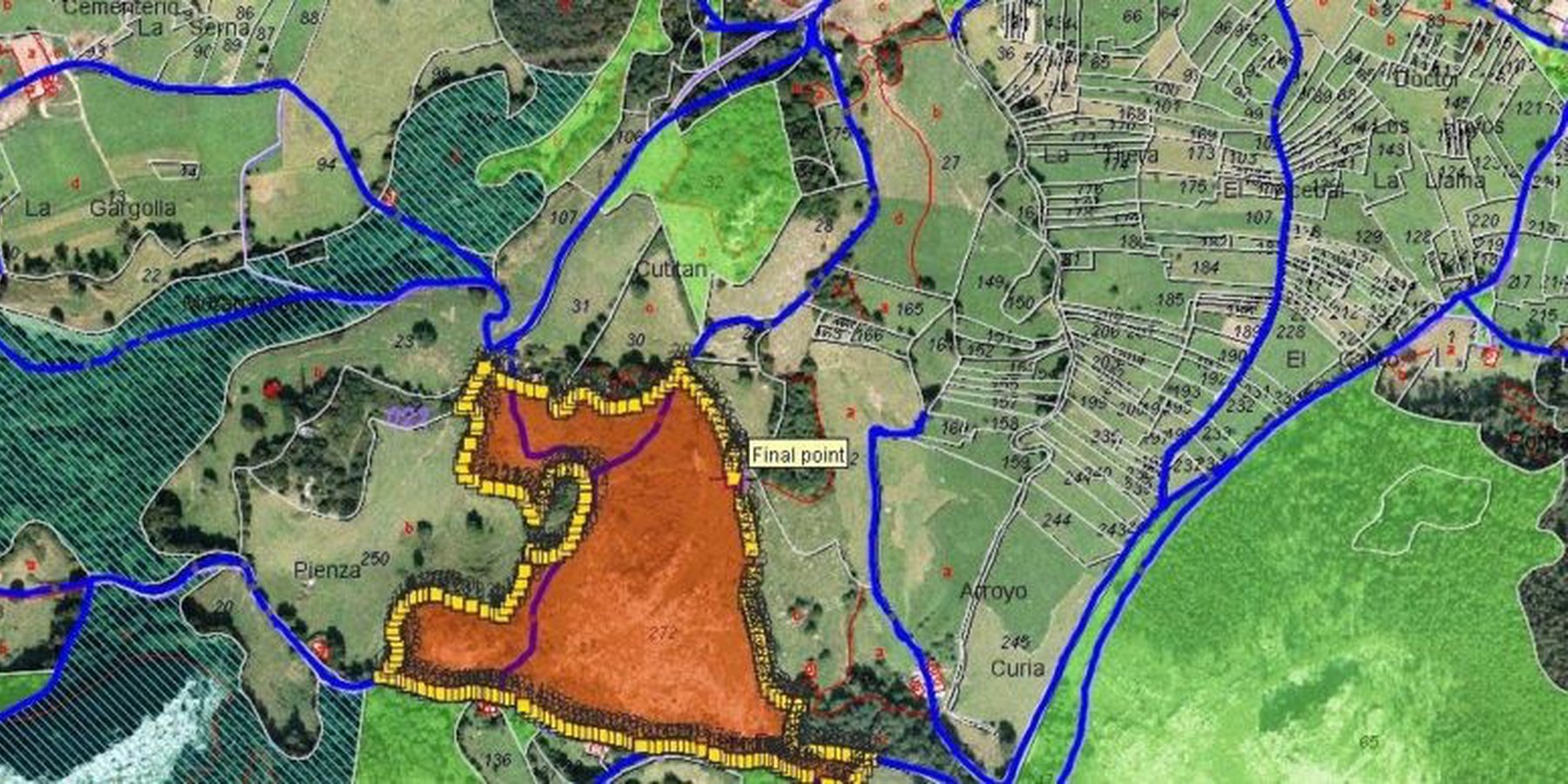
e-Prakriti proposes comprehensive planning by the adequate blending of technology with sustainability approaches, local wisdom, community participation, and departmental convergence.
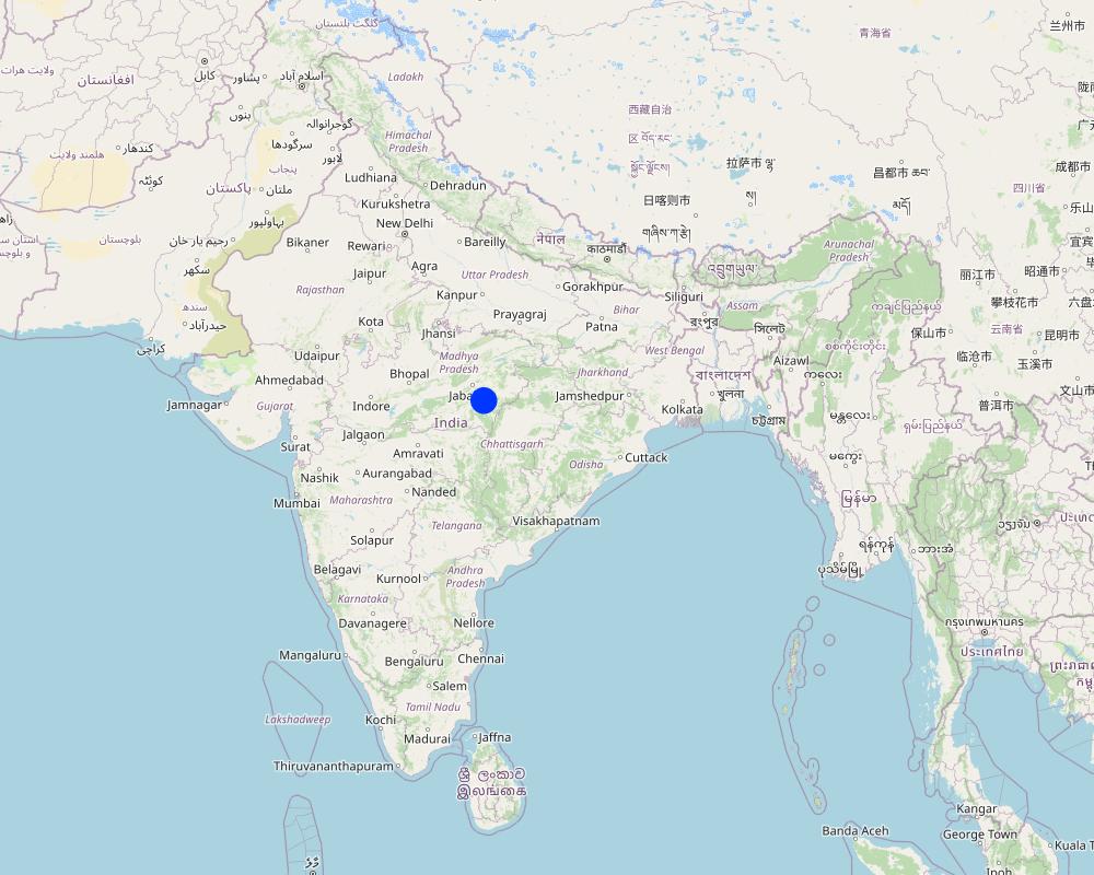
2.5 ປະເທດ / ເຂດ / ສະຖານທີ່ບ່ອນທີ່ແນວທາງໄດ້ຖືກນໍາໃຊ້
ປະເທດ:
ອິນເດຍ
ພາກພື້ນ / ລັດ / ແຂວງ:
Madhya Pradesh
ຂໍ້ມູນເພີ່ມເຕີມຂອງສະຖານທີ່:
Changariya village, Bichiya block,
ຄວາມຄິດເຫັນ:
The Changariya village is a sample site to understand the E-prakriti workbook approach
Map
×2.6 ວັນທີເລີ່ມຕົ້ນ ແລະ ສິ້ນສຸດ ການຈັດຕັ້ງປະຕີບັດ ວິທີທາງ
ຖ້າຫາກບໍ່ຮູ້ຈັກປີທີ່ແນ່ນອນ, ໃຫ້ປະມານຄາດຄະເນ ເອົາມື້ທີ່ໄດ້ເລີ່ມຈັດຕັ້ງປະຕິບັດ ວິທີທາງ:
ຕໍ່າກວ່າ 10 ປີ ຜ່ານມາ (ມາເຖິງປະຈຸບັນ)
ປີທີ່ສີ້ນສູດ (ຖ້າຢຸດບໍ່ໄດ້ນໍາໃຊ້ ວິທີທາງ):
2023
ຄວາມຄິດເຫັນ:
This approach for landscape management considers the landscape as an administrative and natural unit and includes various levels such as Village, Block, District, and geo-hydrological landscapes. It provides a comprehensive activity plan for the management of natural resources, with a focus on natural farming as a core component. The approach is easy to understand and can be used for project implementation.
2.7 ປະເພດຂອງແນວທາງ
- ພາຍໃຕ້ໂຄງການ / ແຜນງານ
2.8 ເປົ້າໝາຍ / ຈຸດປະສົງຫຼັກ ຂອງການຈັດຕັ້ງປະຕິບັດ ວິທີທາງ
The objective of this tool is to create a scientific and efficient approach for planning natural farming interventions through the use of GIS-based mapping
2.9 ເງື່ອນໄຂອໍານວຍ ຫຼື ຂັດຂວາງການປະຕິບັດຂອງເຕັກໂນໂລຢີ / ເຕັກໂນໂລຢີການນໍາໃຊ້ຕາມແນວທາງ
ສັງຄົມ / ວັດທະນະທໍາ / ມາດຕະຖານ ແລະ ຄຸນຄ່າທາງສາສະໜາ
- ອໍານວຍ
E-prakriti proposes comprehensive planning by the adequate blending of technology with sustainability approaches, local wisdom, community participation and departmental convergence
ການກໍ່ຕັ້ງສະຖາບັນ
- ອໍານວຍ
The effective cooperation of actors like communities, Government Departments and other institutions is enabled by natural-farming planning approaches using GIS Tools.
ການຮ່ວມມື / ການປະສານງານຂອງຜູ້ກ່ຽວຂ້ອງ
- ອໍານວຍ
The validation of GIS data is done through on-ground validation and extensive interpretation from maps. Community consultations are crucial in the planning process and convergence planning with the concerned Government Departments is necessary for comprehensive planning. Technical training in basic GIS-based software handling is essential for departmental engineers and other technically competent functionaries.
ຄວາມຮູ້ກ່ຽວກັບການຄຸ້ມຄອງ ທີ່ດິນແບບຍືນຍົງ, ການເຂົ້າເຖິງການສະໜັບສະໜູນ ທາງດ້ານວິຊາການ
- ອໍານວຍ
ວຽກ, ມີກໍາລັງຄົນ
- ອໍານວຍ
e-Prakriti can significantly reduce the workload of planners and implementers as it reduces the need for physical visits to each and every village to collect ground-level data. A lot of data with very high accuracy can be collected from the satellite-based imaging systems.
3. ການມີສ່ວນຮ່ວມ ແລະ ບົດບາດຂອງພາກສ່ວນທີ່ກ່ຽວຂ້ອງທີ່ໄດ້ມີສ່ວນຮ່ວມ
3.1 ຜູ້ມີສ່ວນຮ່ວມ ໃນວິທີທາງ ແລະ ພາລະບົດບາດ ຂອງເຂົາເຈົ້າ
- ຜູ້ນໍາໃຊ້ດິນໃນທ້ອງຖິ່ນ / ຊຸມຊົນທ້ອງຖິ່ນ
Local community members, farmers
They have provided the data and information during the ground proofing exercises
- ອົງການຈັດຕັ້ງ ພາຍໃນຊຸມຊົນ
Local Community - Participation of local groups in implementing the program activities.
Community representatives from villages - support/drive the program's activities.
Community consultations are critical in promoting sustainable development interventions. It is vital to adequately prepare the community for the actions required, and community representatives must be involved at all planning levels, starting from the ground level. The principles of inclusivity and cooperation are crucial in building trust and promoting effective collaboration among community members.
The community's input is essential in creating a suitable action plan and developing maps at the beginning and end of the planning process through larger community consultations. By involving the community in this way, the intervention is more likely to be successful, sustainable and aligned with the community's needs and aspirations. This approach ensures that the community is adequately prepared to undertake the required actions and the intervention is more likely to have a positive impact on the community's well-being in the long run.
- ຜູ້ຊ່ຽວຊານ ການນຄຸ້ມຄອງ ທີ່ດິນແບບຍືນຍົງ / ທີ່ປຶກສາດ້ານກະສິກໍາ
1. Team from GIZ and consultants who developed the e-Prakriti module
2. Specialist from project implementing team
SLM specialists from GIZ, from the implementing agency, other consultants from the domain of GIS and satellite-based applications have developed the e-Prakriti module. They have looked into the specific requirements for planning the natural farming interventions and available open source platforms to meet that requirement. Once this is developed they also did some ground truthing exercises in the field to observe the accuracy of collected data along with application in the field.
- ຄູອາຈານ / ນັກຮຽນ / ນັກສຶກສາ
Local Community Representative (Community Resource Person)
The CRP is trained to use the E-Prakriti tools for planning natural farming practices. He/she engages with village groups and the program team for planning, implementation and execution. They are considered the most important stakeholders in the process as it is expected that CRPs will use this tool in the planning of their activities.
- ອົງການຈັດຕັ້ງ ທີ່ບໍ່ຂື້ນກັບລັດຖະບານ
Foundation for Ecological Security (FES) NGO
FES is involved in piloting the approach in villages, handholding for the implementation and monitoring the work. Scaling up plans with different agencies is undertaken once the piloting is successful and evidence is generated.
- ອໍານາດ ການປົກຄອງທ້ອງຖິ່ນ
Gram Panchayat (village self governing body)
Liaison with different government departments concerned viz. Departments like Water
Resource, NREGS, Animal Husbandry, Agriculture, Horticulture, Panchayat etc.
Convergence planning is crucial for the successful implementation of natural farming as it extensively relies on the utilization of common natural resources. This can only be achieved through the integrated effort of various concerned Departments, such as Water Resources, NREGS, Animal Husbandry, Agriculture, Horticulture, Panchayat, etc.
Therefore, it is essential to hold joint consultations with these departments to ensure that everyone is on the same page and has a shared understanding of the objectives and strategies for natural farming. These consultations can help to identify the potential areas of collaboration and the specific roles and responsibilities of each department in the implementation of natural farming practices.
In addition to engaging with the relevant departments, it is equally important to involve the district administration in the planning process. The District Collector, CEO of Zila, and Block Panchayat can play a facilitative role in bringing together the various departments and stakeholders involved in natural farming, promoting collaboration and convergence among them.
Through effective convergence planning, it is possible to achieve better coordination and utilization of resources, resulting in improved outcomes for natural farming. This will also contribute to the sustainable development of rural communities and the conservation of natural resources in the long run.
- ອົງການຈັດຕັ້ງ ສາກົນ
Deutsche Gesellschaft für Internationale Zusammenarbeit (GIZ) GmbH
Collated the experiences and prepared the workbook that gives an
overview of planning for natural farming using open-source data
3.2 ການມີສ່ວນຮ່ວມຂອງຜູ້ນໍາໃຊ້ທີ່ດິນໃນທ້ອງຖິ່ນ / ຊຸມຊົນທ້ອງຖິ່ນໃນໄລຍະທີ່ແຕກຕ່າງກັນຂອງແນວທາງ
| ການລວບລວມ ເອົາຜູ້ນໍາໃຊ້ດິນ ໃນທ້ອງຖິ່ນ / ຊຸມຊົນທ້ອງຖິ່ນ | ໃຫ້ລະບຸ ຜູ້ໃດທີ່ມີສ່ວນຮ່ວມ ໃນແຕ່ລະກິດຈະກໍາ? | |
|---|---|---|
| ການເລີ່ມຕົ້ນ / ແຮງຈູງໃຈ | ການບໍ່ປະຕິບັດ | They have been discussed to understand their specific needs, resources availability and applications for developing the basic understanding |
| ການວາງແຜນ | ການຮ່ວມມື | Local community institutions were involved in the process of planning to understand the local cost specifications, local cropping patterns and to collect and validate the data points |
| ການປະຕິບັດ | ການນໍາໃໍຊ້ເອງ | Local community institutions did implement the interventions with technical guidance from the project implementing team |
| ຕິດຕາມກວດກາ / ການປະເມີນຜົນ | ການຮ່ວມມື | During the monitoring process images and data points collected from the satellites were physically validated from the community members. Also, discussions are held with communities to understand the social and economic impact of the project interventions. |
3.3 ແຜນວາດ (ຖ້າມີ)

ການອະທິບາຍ:
In order to effectively plan for natural farming using GIS tools, it is important to involve the larger systems around the community and the community itself. The first step is to identify and define a unit of intervention, such as a village. Open-source satellite data can then be used to understand and estimate various factors such as geomorphology and geohydrology. This data can be complemented with other available data from sources such as the Ground Water Board or the NREGS portal.
Using QGIS tool, the various data sets can be superimposed to find relationships between them. On-ground validation (truthing) of the GIS data is also necessary to ensure its accuracy. Once the data sets are gathered, an extensive interpretation from maps is undertaken, and the data is translated into easily understandable and implementable material for the community.
Community consultations are a critical part of the intervention, with community representatives being involved at all levels of planning. Inclusivity and cooperation are key principles in engaging the community and government departments and institutions for the judicious use of common resources. Larger community consultations are held at the beginning and end of the planning process to arrive at a suitable action plan using the prepared maps.
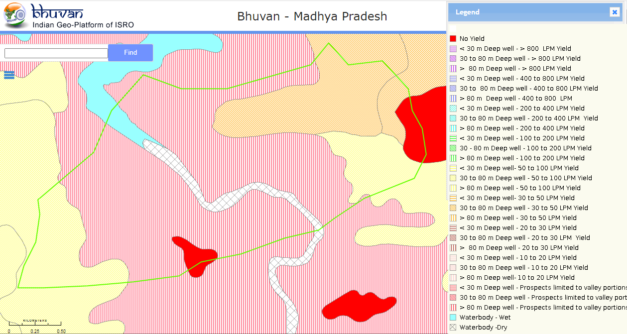
The planned actions and locations are plotted on maps on Google Earth, and convergence planning is necessary for the integrated efforts of several concerned departments. Joint consultations are held with these departments, and the district administration can play a facilitative role in bringing everyone on the same page. Lastly, it is important to train departmental engineers, Rozgar Sahayaks, and other technically competent functionaries in basic GIS-based software such as Bhuvan, QGIS, India-WRIS, and Bhuvan Panchayat to extract necessary data.
ຜູ້ຂຽນ:
Deutsche Gesellschaft für Internationale Zusammenarbeit (GIZ) GmbH
3.4 ການຕັດສິນໃຈກ່ຽວກັບການຄັດເລືອກເຕັກໂນໂລຢີຂອງການຄຸ້ມຄອງທີ່ດິນແບບຍືນຍົງ / ເຕັກໂນໂລຢີ
ລະບຸ ຄົນທີ່ຕັດສິນໃຈ ກ່ຽວກັບການຄັດເລືອກຂອງ ເຕັກໂນໂລຢີ / ເຕັກໂນໂລຢີ ຈະໄດ້ຮັບການປະຕິບັດ:
- ພາກສ່ວນກ່ຽວຂ້ອງທັງໝົດ, ເປັນສ່ວນໜຶ່ງ ຂອງວິທີທາງແບບມີສ່ວນຮ່ວມ
Specify on what basis decisions were made:
- ຜົນທີ່ໄດ້ຮັບ ຈາກການຄົ້ນຄວ້າ
- ປະສົບການສ່ວນບຸກຄົນ ແລະ ຄວາມຄິດເຫັນ (ທີ່ບໍ່ເປັນເອກກະສານ)
4. ການສະໜັບສະໜູນທາງດ້ານວິຊາການ, ການສ້າງຄວາມສາມາດ, ແລະ ການຈັດການຄວາມຮູ້.
4.1 ການສ້າງຄວາມສາມາດ / ການຝຶກອົບຮົມ
ຜູ້ນໍາໃຊ້ທີ່ດິນ ຫຼື ພາກສ່ວນກ່ຽວຂ້ອງອື່ນໆ ໄດ້ຮັບການຝຶກອົບຮົມບໍ່?
ແມ່ນ
ໃຫ້ລະບຸ ຜູ້ໃດທີ່ໄດ້ຮັບການຝຶກອົບຮົມ:
- ພະນັກງານພາກສະໜາມ / ທີ່ປຶກສາ
ຖ້າເປັນໄປໄດ້, ໃຫ້ລະບຸເພດ, ອາຍຸ, ສະຖານະພາບ, ຊົນເຜົ່າ, ແລະ ອື່ນໆ:
The Community resource person is trained on different maps and related interpretations. The first level of planning is made using open GIS sources which are later validated by the CRP along with the community in the village. Once the plan is finalized in a participatory manner, the program is implemented and monitored using the GIS tool.
ຮູບແບບຂອງການຝຶກອົບຮົມ:
- ການເຮັດຕົວຈິງ
- ເນື້ອທີ່ສວນທົດລອງ
- ຫຼັກສູດ
ໃນຫົວຂໍ້:
1 Village boundaries
2 Village Assets and Infrastructure
3 Watershed / Sub-basin Map
4 Natural Drainage line
8 Availability of groundwater
5 Further resources on Water
5 Geomorphology
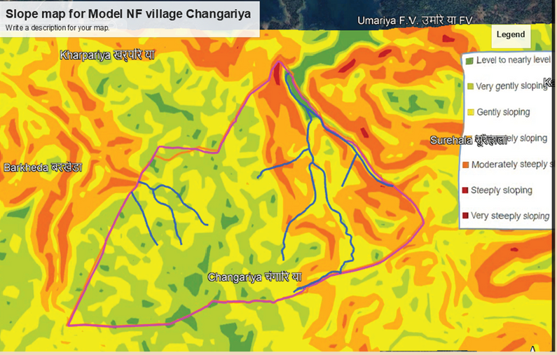
6 Slopes within the topography
7 Lineaments- cracks in the land for the generation of aquifiers
8 Soil Erosion
10 Soil kinds/data
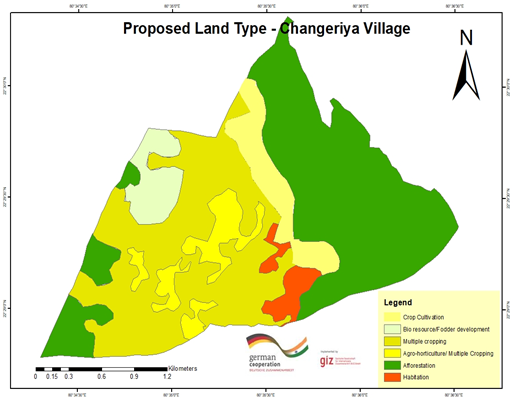
11 Land usage pattern
12 Crop season land
13 Wastelands Map
ຄວາມຄິດເຫັນ:
E-Prakriti is a training module which can be used by various stakeholders for the training and handholding of field team members.
4.2 ການບໍລິການໃຫ້ຄໍາປຶກສາ
ເຮັດຜູ້ໃຊ້ທີ່ດິນມີການເຂົ້າເຖິງການບໍລິການໃຫ້ຄໍາປຶກສາ?
ແມ່ນ
ລະບຸວ່າການສະໜອງ ການບໍລິການ ໃຫ້ຄໍາປຶກສາ:
- ໃນພື້ນທີ່ຂອງຜູ້ນໍາໃຊ້ດິນ
4.3 ສະຖາບັນການສ້າງຄວາມເຂັ້ມແຂງ (ການພັດທະນາອົງການຈັດຕັ້ງ)
ສະຖາບັນ ໄດ້ຮັບການສ້າງຕັ້ງຂື້ນ ຫຼື ໄດ້ຮັບການສ້າງຄວາມເຂັ້ມແຂງ ໂດຍການຈັດຕັ້ງປະຕິບັດ ວິທີທາງບໍ່?
- ບໍ່ມີ
4.4 ຕິດຕາມກວດກາ ແລະ ປະເມີນຜົນ
ການຈັດຕັ້ງປະຕິບັດ ວິທີທາງ ໄດ້ມີການປະເມີນຜົນ ແລະ ຕິດຕາມບໍ?
ແມ່ນ
ຄວາມຄິດເຫັນ:
This tool can be used for monitoring the project interventions by having the pre- and post-project images from the satellite
ຖ້າແມ່ນ, ເອກກະສານສະບັບນີ້ ແມ່ນໄດ້ນໍາໃຊ້ເຂົ້າໃນການຕິດຕາມ ແລະ ປະເມີນຜົນບໍ່?
ບໍ່ແມ່ນ
4.5 ການຄົ້ນຄວ້າ
ນີ້້ແມ່ນສ່ວນໜຶ່ງ ການຄົ້ນຄວ້າ ຂອງວິທີທາງບໍ່?
ບໍ່ແມ່ນ
5. ການສະໜັບສະໜູນທາງດ້ານການເງິນ ແລະ ອຸປະກອນຈາກພາຍນອກ
5.1 ງົບປະມານປະຈໍາປີ ສໍາລັບວິທີທາງ ຂອງການຄຸ້ມຄອງ ທີ່ດິນແບບຍືນຍົງ
ຖ້າຫາກບໍ່ຮູ້ຈັດງົບປະມານທີ່ແນ່ນອນ ແມ່ນໃຫ້ປະມານເອົາ:
- < 2,000
ຄໍາເຫັນ (ຕົວຢ່າງ: ແຫຼ່ງຂໍ້ມູນຫຼັກ ຂອງການສະໜອງທຶນ / ຜູ້ໃຫ້ທຶນທີ່ສໍາຄັນ):
The major cost involved is in developing the e-Prakriti module, the cost of which was incurred by the GIZ.
Another important cost component is capacity building of the stakeholders.
5.2 ການສະໜັບສະໜູນ ທາງດ້ານການເງິນ / ອຸປະກອນ ສະໜອງໃຫ້ແກ່ຜູ້ນໍາທີ່ດິນ
ຜູ້ນໍາໃຊ້ດິນ ໄດ້ຮັບການສະໜັບສະໜູນ ທາງດ້ານ ການເງິນ / ອຸປະກອນ ໃນການຈັດຕັ້ງປະຕິບັດ ເຕັກໂນໂລຢີບໍ?
ບໍ່ແມ່ນ
5.3 ເງິນສົມທົບສໍາລັບການນໍາໃຊ້ສະເພາະປັດໃຈຂາເຂົ້າໃນການຜະລີດກະສິກໍາ (ລວມທັງແຮງງານ)
- ບໍ່ມີ
5.4 ສິນເຊື່ອ
ໄດ້ປ່ອຍສິນເຊື່ອ ສະໜອງໃຫ້ພາຍໃຕ້ ວິທີການສໍາລັບກິດຈະກໍາ ການຄຸ້ມຄອງ ທີ່ດິນແບບຍືນນຍົງບໍ່?
ບໍ່ແມ່ນ
5.5 ສິ່ງຈູງໃຈ ຫຼື ເຄື່ອງມືອື່ນໆ
ການສົ່ງເສີມ ຈັດຕັ້ງປະຕິບັດ ເຕັກໂນໂລຢີ ໃນການຄຸ້ມຄອງ ດິນແບບຍືນຍົງ ໄດ້ສະໜອງສິ່ງກະຕຸກຊຸກຍູ້ບໍ່?
ແມ່ນ
ຖ້າແມ່ນ, ໃຫ້ລະບຸ:
Training and handholding of stakeholders
6. ວິເຄາະຜົນກະທົບ ແລະ ສັງລວມບັນຫາ
6.1 ຜົນກະທົບຂອງແນວທາງ
ວິທີທາງ ຊ່ວຍຊຸກຍູ້ ຜູ້ນຳໃຊ້ທີ່ດິນທ້ອງຖີ່ນ, ໃນການປັບປຸງ ການມີສ່ວນຮ່ວມ ຂອງຜູ້ທີ່ກ່ຽວຂ້ອງ ບໍ່?
- ບໍ່
- ມີ, ໜ້ອຍໜຶ່ງ
- ມີ, ພໍສົມຄວນ
- ມີ, ຫຼາຍ
The targeted areas that specifically needed conservation work were focused on
ການນໍາໃຊ້ ວິທີທາງ ດັ່ງກ່າວນີ້ ສາມາດເປັນຫຼັກຖານ ທີ່ສະໜັບສະໜູນ ໃຫ້ການຕັດສິນໃຈໄດ້ບໍ່?
- ບໍ່
- ມີ, ໜ້ອຍໜຶ່ງ
- ມີ, ພໍສົມຄວນ
- ມີ, ຫຼາຍ
This has been the most important purpose of this approach. The use of various spatial tools ensured evidence-based decision-making
ການຈັດຕັ້ງປະຕິບັດ ວິທີທາງ ສາມາດຊ່ວຍຜູ້ນໍາໃຊ້ທີ່ດິນ ໃນການຈັດຕັ້ງປະຕິບັດ ແລະ ບໍາລຸງຮັກສາ ເຕັກໂນໂລຢີ ການຄຸ້ມຄອງ ທີ່ດິນແບບຍືນຍົງໄດ້ບໍ?
- ບໍ່
- ມີ, ໜ້ອຍໜຶ່ງ
- ມີ, ພໍສົມຄວນ
- ມີ, ຫຼາຍ
The approach may be a great tool for effective and efficient natural farming-based practices and other SLM technologies
ການນໍາໃຊ້ ວິທີທາງ ສາມາດປັບປຸງ ການປະສານງານ ແລະ ຄ່າໃຊ້ຈ່າຍ ການຈັດຕັ້ງປະຕິບັດ ທີ່ມີປະສິດທິພາບ ຂອງການຄຸ້ມຄອງ ທີ່ດິນແບບຍືດຍົງໄດ້ບໍ່?
- ບໍ່
- ມີ, ໜ້ອຍໜຶ່ງ
- ມີ, ພໍສົມຄວນ
- ມີ, ຫຼາຍ
Yes. It has been of great use
ການນໍາໃຊ້ ວິທີທາງ ສາມາດລະດົມ ຫຼື ປັບປຸງ ການເຂົ້າເຖິງຊັບພະຍາກອນ ການເງິນ ສໍາລັບການຈັດຕັ້ງປະຕິບັດ ການຄຸ້ມຄອງ ທີ່ດິນແບບຍືດຍົງໄດ້ບໍ່?
- ບໍ່
- ມີ, ໜ້ອຍໜຶ່ງ
- ມີ, ພໍສົມຄວນ
- ມີ, ຫຼາຍ
Developing projects using the technology has ensured effective financial planning for the planned interventions
ການນໍາໃຊ້ ວິທີທາງ ສາມາດປັບປຸງຄວາມຮູ້ ແລະ ຄວາມສາມາດຂອງຜູ້ນໍາໃຊ້ທີ່ດິນ ໃນການປະຕິບັດ ການຄຸ້ມຄອງ ທີ່ດິນແບບຍືດຍົງໄດ້ບໍ່?
- ບໍ່
- ມີ, ໜ້ອຍໜຶ່ງ
- ມີ, ພໍສົມຄວນ
- ມີ, ຫຼາຍ
Land users and local community resource persons learned about the various tools and technologies available for scientific planning
ການນໍາໃຊ້ ວິທີທາງ ສາມາດປັບປຸງຄວາມຮູ້ ແລະ ຄວາມສາມາດ ຂອງພາກສ່ວນທີ່ກ່ຽວຂ້ອງໄດ້ບໍ່?
- ບໍ່
- ມີ, ໜ້ອຍໜຶ່ງ
- ມີ, ພໍສົມຄວນ
- ມີ, ຫຼາຍ
Community resource persons
ການນໍາໃຊ້ ວິທີທາງ ສາມາດສ້າງຄວາມເຂັ້ມແຂງ ໃຫ້ສະຖາບັນການຈັດຕັ້ງ, ການຮ່ວມມື ລະຫວ່າງພາກສ່ວນທີ່ກ່ຽວຂ້ອງບໍ່?
- ບໍ່
- ມີ, ໜ້ອຍໜຶ່ງ
- ມີ, ພໍສົມຄວນ
- ມີ, ຫຼາຍ
Stakeholders like farmers, FPOs, local community resource persons, NGOs, Government institutions all are in a position to apply a coordinated approach by using this tool
ການນໍາໃຊ້ ວິທີທາງ ສາມາດຫຼຸດຜ່ອນ ຂໍ້ຂັດແຍ່ງໄດ້ບໍ່?
- ບໍ່
- ມີ, ໜ້ອຍໜຶ່ງ
- ມີ, ພໍສົມຄວນ
- ມີ, ຫຼາຍ
Better mapping of resources could mitigate some conflicts among the community members
ການຈັດຕັ້ງປະຕິບັດ ວິທີທາງ ສາມາດປັບປຸງ ຄວາມສະເໜີພາບ ຂອງບົດບາດ ຍິງຊາຍ ແລະ ສ້າງຄວາມເຂັ້ມແຂງໃຫ້ຜູ້ຍິງໄດ້ບໍ່?
- ບໍ່
- ມີ, ໜ້ອຍໜຶ່ງ
- ມີ, ພໍສົມຄວນ
- ມີ, ຫຼາຍ
The promotion of natural farming empowers women members as they are core to it. Families get an access to safe and healthy foods as well.
ການຈັດຕັ້ງປະຕິບັດ ວິທີທາງ ສາມາດຊຸກຍູ້ ຜູ້ນໍາໃຊ້ທີ່ດິນທີ່ເປັນຊາວໜຸ່ມ / ຄົນລຸ້ນໃໝ່ ໃນການຄຸ້ມຄອງ ທີ່ດິນແບບຍືນຍົງໄດ້ບໍ?
- ບໍ່
- ມີ, ໜ້ອຍໜຶ່ງ
- ມີ, ພໍສົມຄວນ
- ມີ, ຫຼາຍ
ການນໍາໃຊ້ ວິທີທາງ ໄດ້ປັບປຸງ ການນໍາໃຊ້ແຫຼ່ງພະລັງງານ ແບບຍືນຍົງຫຼາຍຂື້ນບໍ່?
- ບໍ່
- ມີ, ໜ້ອຍໜຶ່ງ
- ມີ, ພໍສົມຄວນ
- ມີ, ຫຼາຍ
ການຈັດຕັ້ງປະຕິບັດ ວິທີທາງ ສາມາດສ້າງຄວາມອາດສາມາດໃຫ້ຜູ້ນໍາໃຊ້ດິນ ໃນການປັບຕົວ ຕໍ່ການປ່ຽນແປງດິນຟ້າອາກາດ / ຫຼດຜ່ອນຄວາມສ່ຽງທາງໄພພິບັດໄດ້ບໍ? :
- ບໍ່
- ມີ, ໜ້ອຍໜຶ່ງ
- ມີ, ພໍສົມຄວນ
- ມີ, ຫຼາຍ
6.2 ແຮງຈູງໃຈຫຼັກຂອງຜູ້ນໍາໃຊ້ທີ່ດິນໃນການປະຕິບັດການຄຸ້ມຄອງທີ່ດິນແບບຍືນຍົງ
- ການຫຼຸດຜ່ອນພາລະວຽກ
The approach reduces the work load during the planning and monitoring stages
- ຄວາມຮັບຮູ້ ທາງສີ່ງແວດລ້ອມ
Natural farming, watershed management, efficient use of the resources
- ການປັບປຸງ ຄວາມຮູ້ ແລະ ຄວາມສາມາດ ຂອງການຄຸ້ມຄອງ ທີ່ດິນແບບຍືນຍົງ
6.3 ຄວາມຍືນຍົງຂອງກິດຈະກໍາວິທີທາງ
ຜູ້ນໍາໃຊ້ ທີ່ດິນ ສາມາດສືບຕໍ່ ການຈັດຕັ້ງປະຕິບັດ ຜ່ານວິທີທາງໄດ້ບໍ່ (ໂດຍປາດສະຈາກ ການຊ່ວຍເຫຼືອ ຈາກພາກສ່ວນພາຍນອກ)?
- ແມ່ນ
ຖ້າ ໄດ້, ອະທິບາຍເຫດຜົນ:
The approach developed is a guidebook, which can be used by anyone using the available open-access platform which is free to use
6.4 ຈຸດແຂງ / ຂໍ້ດີ ຂອງວິທີທາງ
| ຈຸດແຂງ / ຂໍ້ດີ / ໂອກາດໃນການນໍາໃຊ້ທີ່ດິນ |
|---|
| Efficient mapping of the resources available to different stakeholders which sometimes community members may not be aware of |
| Convergence opportunities with different line departments once resources are mapped and activities are finalised |
| Reduced workload of the community members and their institutions as they need not be physically present every time |
| ຈຸດແຂງ / ຈຸດດີ / ໂອກາດ ຈາກທັດສະນະຂອງຜູ້ປ້ອນຂໍ້ມູນ ຫຼື ບຸກຄົນສຳຄັນ |
|---|
| Scientific and evidence based method of planning with a lot of saving in time and resources with better accuracy. Sometimes connecting with communities as well as visiting field areas take a lot of time. |
| The approach can also be used for developing the financial outlays for the shortlisted interventions by getting the physical inputs, conducting the assessments through images and maps collected from open access platforms |
| The e-Prakriti approach can be very effective in the monitoring of the project interventions as satellite-based maps of pre- and post-interventions or geotagged images may provide scientific evidences |
6.5 ຈຸດອ່ອນ / ຂໍ້ເສຍຂອງແນວທາງ ແລະ ວິທີການແກ້ໄຂໃຫ້ເຂົາເຈົ້າ
| ຈຸດອ່ອນ / ຂໍ້ເສຍ / ຄວາມສ່ຽງໃນມູມມອງຂອງຜູ້ນໍາໃຊ້ທີ່ດິນ | ມີວິທີການແກ້ໄຂຄືແນວໃດ? |
|---|---|
| Not much exposed to this approach for planning | Handholding through demonstrations |
| Availability of computer devices to access the maps | Although computers are available at affordable prices in some cases, there may be financial support from the project or government agencies |
| ຈຸດອ່ອນ ຫຼື ຂໍ້ເສຍ ຫຼື ຄວາມສ່ຽງ ໃນມຸມມອງຂອງ ຜູ້ສັງລວມຂໍ້ມູນ ຫຼື ບັນດາຜູ້ຕອບແບບສອບຖາມ | ມີວິທີການແກ້ໄຂຄືແນວໃດ? |
|---|---|
| Technology keeps on updating thus the users need to update and upgrade themselves to ensure the usages at ground | Regular training and handholding of the users either physically or remotely |
| Availability of high speed internet for using the platforms; Currently most land users and CRPs do use internet using their mobile hotspots, access to wi-fi may may not be there | Identified planners or CRPs can be provided with internet devices or they can be linked with Wi-Fi available at different Government bodies |
7. ເອກກະສານອ້າງອີງ ແລະ ຂໍ້ມູນການເຊື່ອມໂຍງ
7.1 ວິທີການ / ແຫຼ່ງຂໍ້ມູນ
- ສໍາພາດ ຊ່ຽວຊານ ການຄຸ້ມຄອງ ດິນແບບຍືນຍົງ
2
- ການລວບລວມ ບົດລາຍງານ ແລະ ເອກະສານອື່ນໆ ທີ່ມີຢູ່ແລ້ວ
2
7.3 ການເຊື່ອມຕໍ່ກັບຂໍ້ມູນທີ່ກ່ຽວຂ້ອງທີ່ສາມາດໃຊ້ອອນໄລນ໌
ຫົວຂໍ້ / ພັນລະນາ:
e-Prakriti for comprehensive planning of natural farming practices
URL:
Physical copy shared by GIZ
ຂໍ້ມູນການເຊື່ອມຕໍ່ ແລະ ເນື້ອໃນ
ຂະຫຍາຍທັງໝົດ ຍຸບທັງໝົດການເຊື່ອມຕໍ່
ບໍ່ມີຂໍ້ມູນການເຊື່ອມຕໍ່
ເນື້ອໃນ
ບໍ່ມີເນື້ອໃນ