Participatory Net Planning for Sustainable Watershed Management [ອິນເດຍ]
- ການສ້າງ:
- ປັບປູງ:
- ຜູ້ສັງລວມຂໍ້ມູນ: Arun Bhagat
- ບັນນາທິການ: –
- ຜູ້ທົບທວນຄືນ: Udo Höggel
Participatory Net Planning – A tool that involves stakeholders in planning, developing, and managing their land and natural resources
approaches_7651 - ອິນເດຍ
ເບິ່ງພາກສ່ວນ
ຂະຫຍາຍທັງໝົດ ຍຸບທັງໝົດ1. ຂໍ້ມູນທົ່ວໄປ
1.2 ລາຍລະອຽດ ການຕິດຕໍ່ ຂອງບຸກຄົນທີ່ຊັບພະຍາກອນ ແລະ ສະຖາບັນ ການມີສ່ວນຮ່ວມ ໃນການປະເມີນຜົນ ແລະ ເອກະສານ ຂອງວິທີທາງ
ບຸກຄົນສຳຄັນ (ຫຼາຍຄົນ)
ຜູ້ຊ່ຽວຊານ ດ້ານການຄຸ້ມຄອງ ທີ່ດິນແບບຍືນຍົງ:
Kalaskar Prashant
+91 9403961586
prashant.kalaskar@wotr.org.in
Watershed Organisation Trust (WOTR), Pune
Watershed Organisation Trust (WOTR), Gitai, 1st Floor, New Nagar Road, Sangamner – 422605, Dist. Ahmednagar, Maharashtra, India
ອິນເດຍ
ຜູ້ຊ່ຽວຊານ ດ້ານການຄຸ້ມຄອງ ທີ່ດິນແບບຍືນຍົງ:
D’Souza Marcella
+91 9422226415
marcella.dsouza@gmail.com
W-CReS (the WOTR Centre for Resilience Studies), Watershed Organisation Trust (WOTR), Pune
The Forum, 2nd Floor, Pune - Satara Rd, above Ranka Jewellers, Padmavati Nagar, Corner, Pune, Maharashtra 411009 (India)
ອິນເດຍ
ຜູ້ຊ່ຽວຊານ ດ້ານການຄຸ້ມຄອງ ທີ່ດິນແບບຍືນຍົງ:
ຜູ້ຊ່ຽວຊານ ດ້ານການຄຸ້ມຄອງ ທີ່ດິນແບບຍືນຍົງ:
Solanky Vijay
+91 8824144388
vijay.solanky@wotr.org.in
W-CReS (the WOTR Centre for Resilience Studies), Watershed Organisation Trust (WOTR), Pune
The Forum, 2nd Floor, Pune - Satara Rd, above Ranka Jewellers, Padmavati Nagar, Corner, Pune, Maharashtra 411009 (India)
ອິນເດຍ
ຊື່ຂອງໂຄງການ ທີ່ອໍານວຍຄວາມສະດວກ ໃນການສ້າງເອກກະສານ ຫຼື ປະເມີນດ້ານແນວທາງ (ຖ້າກ່ຽວຂ້ອງ)
Applying Landscape and Sustainable Land Management (L-SLM) for mitigating land degradation and contributing to poverty reduction in rural area (L-SLM Project)ຊື່ຂອງ ສະຖາບັນການຈັດຕັ້ງ ທີ່ອໍານວຍຄວາມສະດວກ ໃນການສ້າງເອກກະສານ ຫຼື ປະເມີນແນວທາງ (ຖ້າກ່ຽວຂ້ອງ)
Watershed Organisation Trust (WOTR) - ອິນເດຍ1.3 ເງື່ອນໄຂ ຂອງການນໍາໃຊ້ເອກກະສານຂໍ້ມູນ ຂອງ WOCAT
ເມື່ອໃດທີ່ໄດ້ສັງລວມຂໍ້ມູນ (ຢູ່ພາກສະໜາມ)?
18/09/2025
ຜູ້ສັງລວມ ແລະ ບັນດາຜູ້ຕອບແບບສອບຖາມ ຍອມຮັບໃນເງື່ອນໄຂ ການນໍາໃຊ້ຂໍ້ມູນເອກະສານ ທີ່ສ້າງຂື້ນ ໂດຍຜ່ານ ອົງການ WOCAT:
ແມ່ນ
2. ພັນລະນາ ແນວທາງການຄຸ້ມຄອງນໍາໃຊ້ດິນແບບຍືນຍົງ
2.1 ການອະທິບາຍ ໂດຍຫຍໍ້ ຂອງວິທີທາງ
Participatory Net Planning (PNP) is a practical methodology that actively engages landowners and local stakeholders in planning and implementing measures for land use, soil conservation, water harvesting, and biomass development. It aims to regenerate ecosystems and improve the sustainability of watersheds through site-specific resource management. PNP emphasizes the conservation, productivity enhancement, and sustainable use of natural and biological resources. It involves assessing the current condition and use of land, water, and vegetation, and preparing detailed plans—with estimated costs and timelines—to achieve the desired outcomes.
In Participatory Net Planning (PNP), the term “Net” represents a complete and interconnected planning framework where every land parcel within a watershed is individually assessed and linked to the larger watershed system. It highlights a network-based approach that integrates soil, water, vegetation, and community needs, ensuring that interventions on one farm support resource conservation and productivity across neighboring and downstream lands. Overall, it signifies a holistic and coordinated system where all stakeholders and resources are planned collectively for sustainable and long-term watershed management.
2.2 ການອະທິບາຍ ລາຍລະອຽດ ຂອງວິທີທາງ
ການອະທິບາຍ ລາຍລະອຽດ ຂອງວິທີທາງ:
By design, PNP functions as a tool for mobilization, training, monitoring, and evaluation in watershed programs.
Its key objectives are:
•Building ownership and commitment among landowners and stakeholders to ensure the long-term sustainability of watershed interventions.
•Planning site-specific measures that meet local needs, improve productivity, and address resource challenges.
•Developing realistic plans with clear activities, budgets, and timelines that can be implemented effectively, minimizing gaps between planned and actual outcomes.
The PNP approach places stakeholders at the center of the process. Landowners, farmers (both men and women), or users of Common Property Resources (CPRs) are directly involved in decision-making for their land or shared resources. During PNP exercises, the planning team visits each landholding or CPR along with the concerned stakeholders to jointly survey, assess, and plan interventions.
Stakeholders share their views on current and proposed land use and the necessary soil and water conservation treatments. The team discusses best practices and scientific options for land management, explaining their benefits and suitability. The final decision on interventions rests with the stakeholder—except when proposed actions could harm neighboring lands, CPRs, or the environment. In such cases, efforts are made to reach a consensus; if not possible, treatments on that land are withheld.
Once agreement is reached, the proposed measures are documented in writing and mapped on a diagram of the land or CPR.
PNP is gender-inclusive, ensuring both men and women participate in planning and decision-making. Ideally, the farming couple or land-owning couple is present during planning, even when land is officially registered in the man’s name. For CPRs, where stakeholders include landless people, marginal farmers, livestock owners, and shepherd communities, institutions like the Village Watershed Committee (VWC), Village Development Committee (VDC), and Gram Panchayat (GP) are involved. Their role is to ensure equitable access to ressources, manage conflicts, and establish transparent and representative local institutions for sustainable management of CPRs and create assets.
The Participatory Net Plan is more than just a planning document—it serves as a blueprint for implementation. Written in the local language, it remains accessible to stakeholders for regular reference. The plan is flexible and adaptive, evolving as new information emerges or stakeholders revise their preferences. Thus, it acts as a “living document” that supports transparency, continuous monitoring, and accountability.
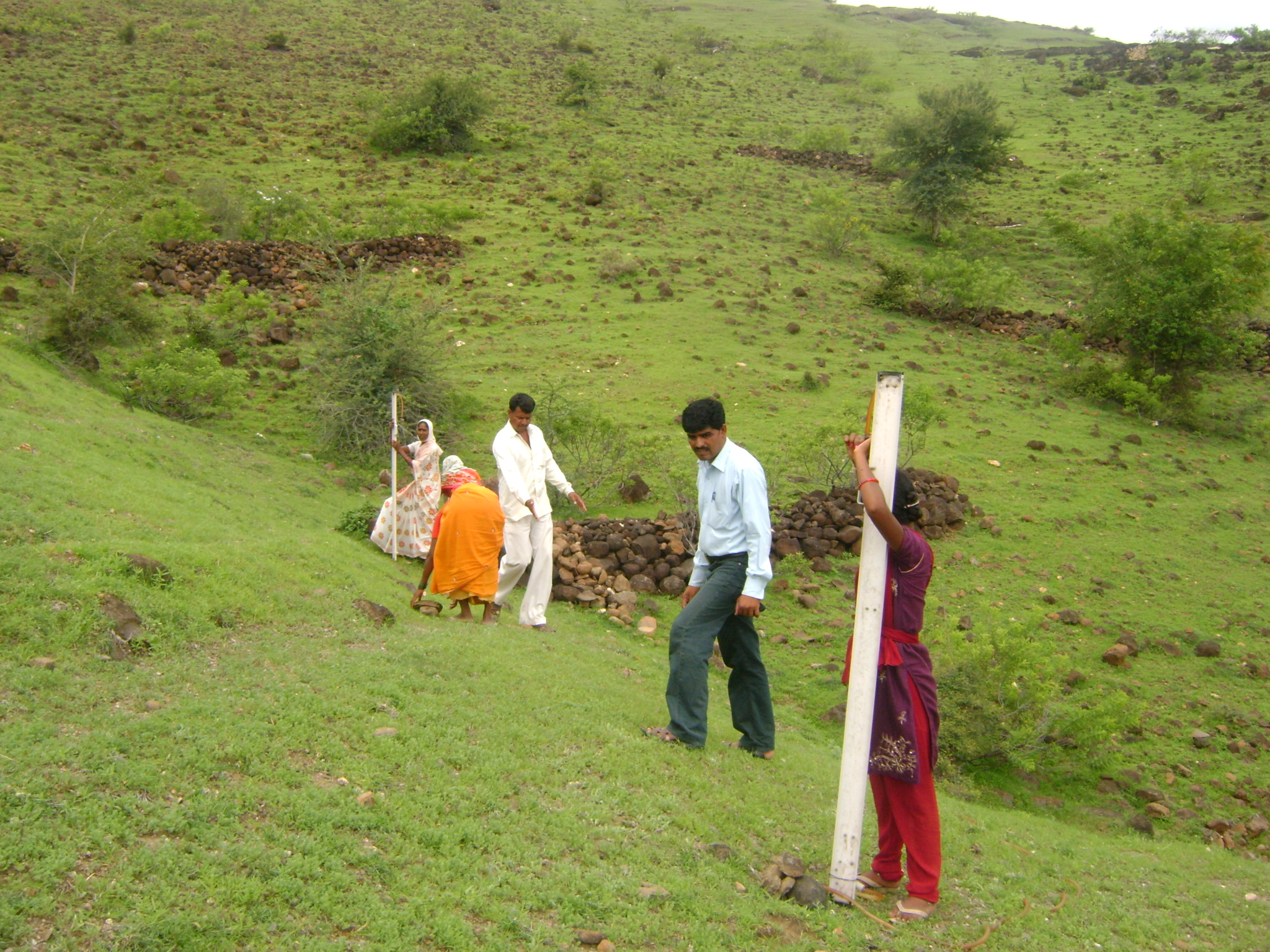
2.3 ຮູບພາບຂອງແນວທາງ
ສື່ຮູບພາບ
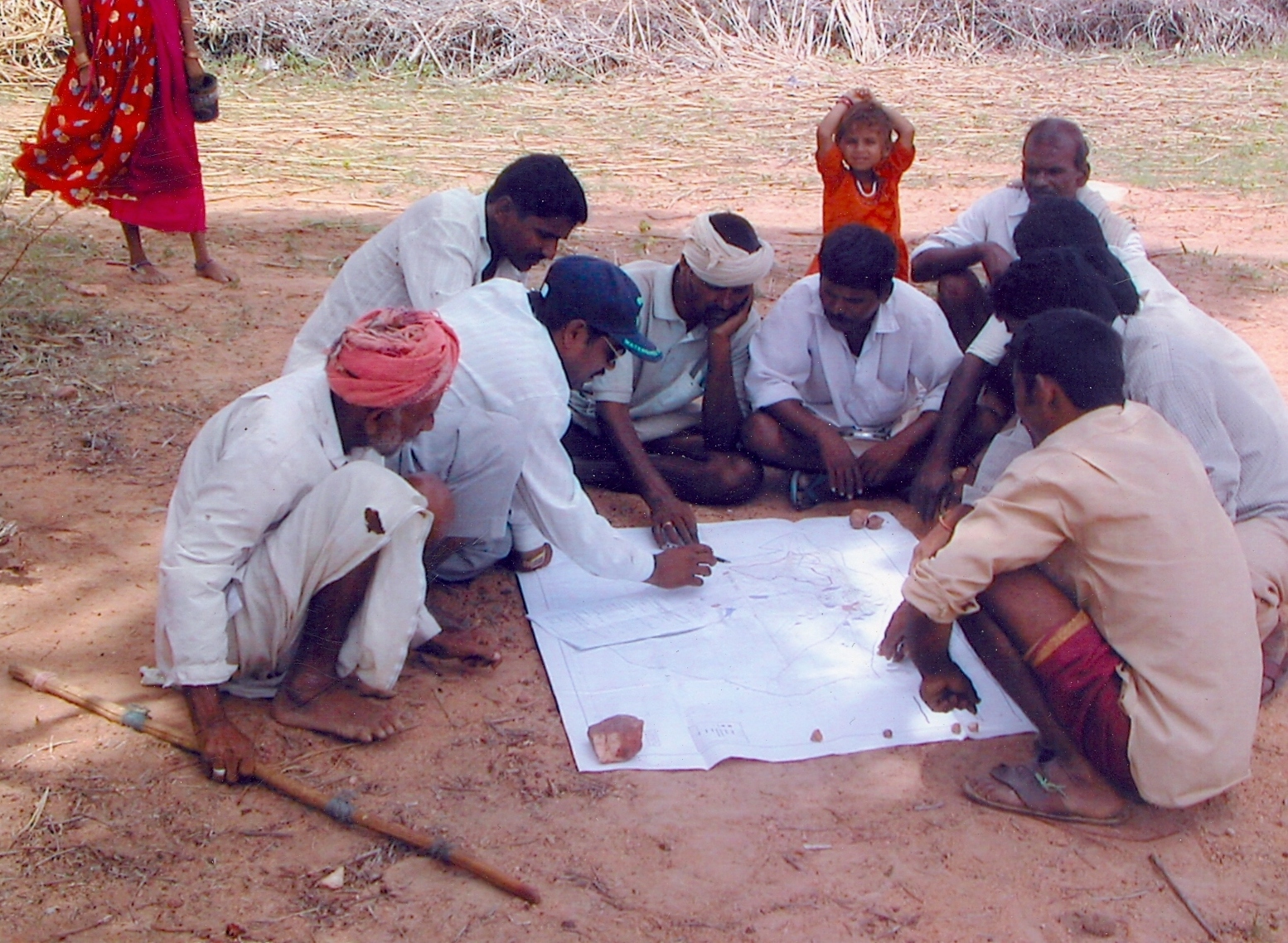
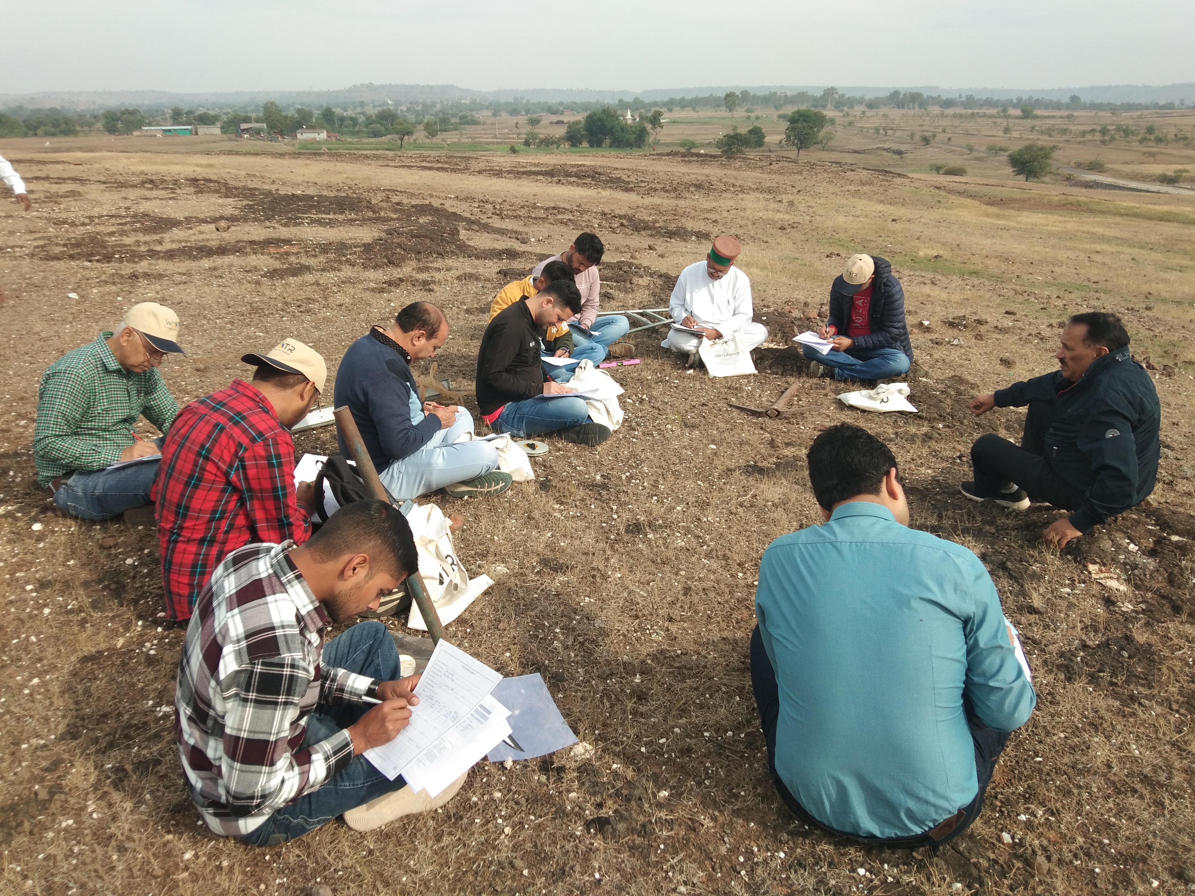
ຂໍ້ສັງເກດໂດຍທົ່ວໄປກ່ຽວກັບການຮູບພາບ:
The photos capture active community participation, field discussions, and collaborative decision-making between farmers and experts during the PNP process, reflecting practical learning and collective planning for sustainable land management.
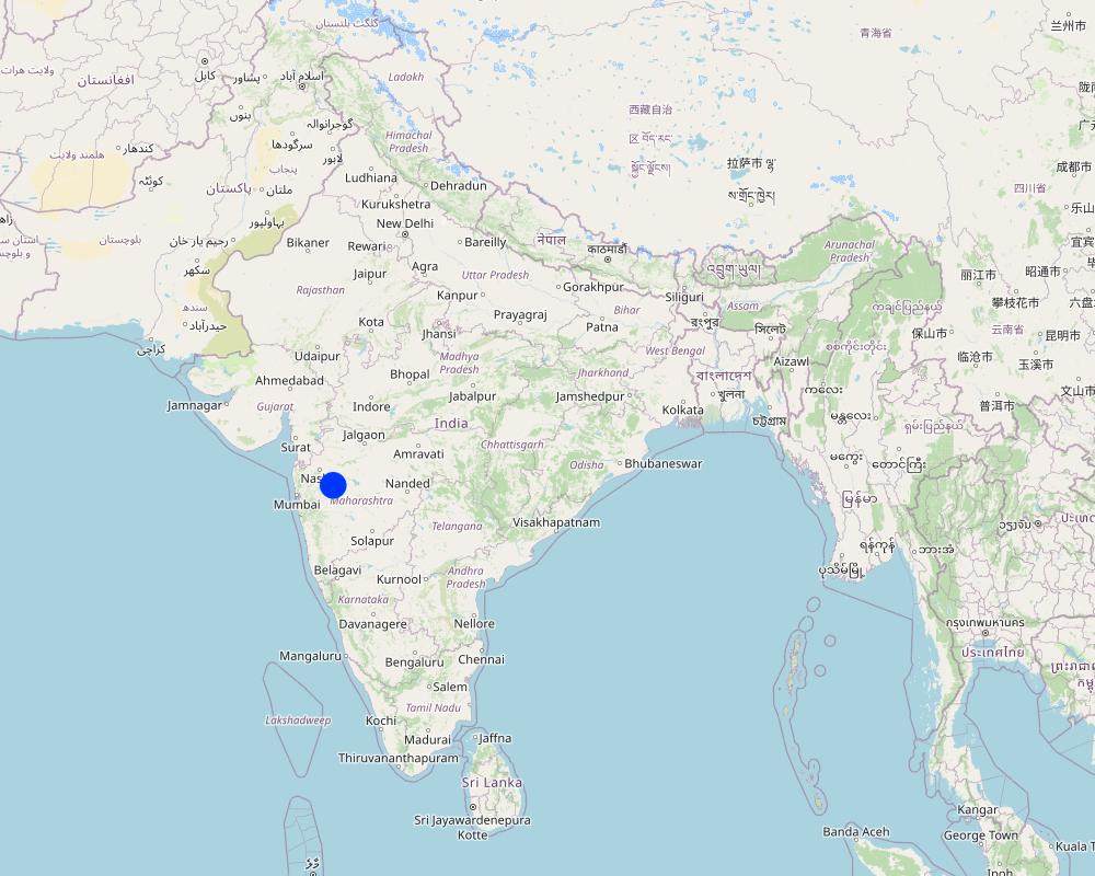
2.5 ປະເທດ / ເຂດ / ສະຖານທີ່ບ່ອນທີ່ແນວທາງໄດ້ຖືກນໍາໃຊ້
ປະເທດ:
ອິນເດຍ
ພາກພື້ນ / ລັດ / ແຂວງ:
Maharashtra
ຂໍ້ມູນເພີ່ມເຕີມຂອງສະຖານທີ່:
Darewadi,Post. Kauthe Malkapur, Taluka Sangamner, Dist. Ahilyanagar,
ຄວາມຄິດເຫັນ:
The Participatory Net Planning (PNP) approach was first implemented in Darewadi village, located in Kauthe Malkapur post, Sangamner taluka, Ahilyanagar district, Maharashtra, India.
Map
×2.6 ວັນທີເລີ່ມຕົ້ນ ແລະ ສິ້ນສຸດ ການຈັດຕັ້ງປະຕີບັດ ວິທີທາງ
ສະແດງປີຂອງການເລີ່ມຕົ້ນ:
1995
2.7 ປະເພດຂອງແນວທາງ
- ພາຍໃຕ້ໂຄງການ / ແຜນງານ
2.8 ເປົ້າໝາຍ / ຈຸດປະສົງຫຼັກ ຂອງການຈັດຕັ້ງປະຕິບັດ ວິທີທາງ
The main objectives of Participatory Net Planning (PNP) are:
•To build a sense of ownership and commitment among landowners and other stakeholders within a watershed, ensuring long-term sustainability of the implemented measures.
•To plan site-specific interventions, meet stakeholder needs, and enhance land and water productivity.
•To develop practical proposals with clear activities, budgets, and timelines that ensure planned measures are effectively implemented and easily scaled up.
2.9 ເງື່ອນໄຂອໍານວຍ ຫຼື ຂັດຂວາງການປະຕິບັດຂອງເຕັກໂນໂລຢີ / ເຕັກໂນໂລຢີການນໍາໃຊ້ຕາມແນວທາງ
ສັງຄົມ / ວັດທະນະທໍາ / ມາດຕະຖານ ແລະ ຄຸນຄ່າທາງສາສະໜາ
- ອໍານວຍ
Strong local bonding, traditional mutual-help systems (e.g., shramdaan), and trust in community leadership support smooth mobilization, joint action, and quick adoption of land and water measures.
- ເຊື່ອງຊ້ອນ
Social hierarchies, reluctance to change established practices, or participation limited to men may exclude key decision-makers, reducing inclusiveness and impact.
ມີຄວາມສາມາດ / ເຂັ້າເຖິງຊັບພະຍາກອນດ້ານການເງິນ ແລະ ການບໍລິການ
- ອໍານວຍ
Availability of subsidies, project funds, bank credit, and SHG financing allows farmers to adopt technologies like bunding, trenching, or water harvesting without major financial stress.
- ເຊື່ອງຊ້ອນ
High upfront costs, inadequate financial literacy, and slow fund release discourage participation and may lead to incomplete works.
ການກໍ່ຕັ້ງສະຖາບັນ
- ອໍານວຍ
Strong and well-functioning institutions (VDC, GP, watershed committees) ensure better planning, dispute resolution, and accountability, increasing project success.
- ເຊື່ອງຊ້ອນ
Weak institutions and lack of leadership create delays, communication gaps, and poor transparency in decision-making.
ການຮ່ວມມື / ການປະສານງານຂອງຜູ້ກ່ຽວຂ້ອງ
- ອໍານວຍ
Active support from multiple actors — technical experts, government departments, and villagers — promotes effective knowledge exchange and faster implementation.
- ເຊື່ອງຊ້ອນ
Misalignment in roles, unclear responsibilities, or lack of coordination slows progress and reduces effectiveness of interventions.
ກ່ຽວກັບກົດໝາຍ (ສິດນໍາໃຊ້ດິນ, ສິດນໍາໃຊ້ນໍ້າ)
- ອໍານວຍ
Clear land ownership provides confidence for farmers to invest in long-term land improvement practices since they benefit directly from gains.
- ເຊື່ອງຊ້ອນ
Disputed titles, tenancy issues, or unclear CPR access rights delay planning and restrict work, especially on shared lands.
ນະໂຍບາຍ
- ອໍານວຍ
Supportive agricultural, watershed, and rural development policies provide strong institutional backing, technical support, and long-term vision.
- ເຊື່ອງຊ້ອນ
Frequent changes in guidelines, budget cuts, or administrative barriers disrupt continuity in planning and execution.
ການປົກຄອງທີ່ດິນ (ການຕັດສິນໃຈ, ການປະຕິບັດ ແລະ ຂໍ້ບັງຄັບ)
- ອໍານວຍ
Fair and transparent governance ensures equal benefits, compliance with planned measures, and responsible use of natural resources.
- ເຊື່ອງຊ້ອນ
Ineffective enforcement or favoritism creates distrust, conflicts, and irregular implementation outcomes.
ຄວາມຮູ້ກ່ຽວກັບການຄຸ້ມຄອງ ທີ່ດິນແບບຍືນຍົງ, ການເຂົ້າເຖິງການສະໜັບສະໜູນ ທາງດ້ານວິຊາການ
- ອໍານວຍ
Farmer training, exposure visits, and expert guidance improve understanding of benefits, correct design, and maintenance of SWC structures.
- ເຊື່ອງຊ້ອນ
Limited technical support results in poor-quality structures and reduced confidence among farmers.
ຕະຫຼາດ (ໃນການຊື້ວັດຖຸດິບ, ຂາຍຜະລິດຕະພັນ) ແລະ ລາຄາ
- ອໍານວຍ
Ready access to markets motivates farmers to adopt improved land use and productivity-enhancing measures since profits increase.
- ເຊື່ອງຊ້ອນ
Price volatility and distant markets reduce economic incentives for adopting new technologies or crop diversification.
ວຽກ, ມີກໍາລັງຄົນ
- ອໍານວຍ
Local labor availability and farmer involvement ensure timely execution, especially before monsoon when structures are most effective.
- ເຊື່ອງຊ້ອນ
Rural migration and labor shortages lead to delays, rushed construction, or higher labor costs.
ອື່ນໆ
- ອໍານວຍ
Climate and weather conditions:
Normal rainfall ensures proper functioning of trenches, bunds, and vegetation growth, validating the benefits of interventions.
- ເຊື່ອງຊ້ອນ
Climate and weather conditions:
Droughts, heavy storms, or irregular monsoons cause structure damage or reduced productivity, lowering adoption enthusiasm.
ອື່ນໆ
- ອໍານວຍ
Accessibility & terrain:
Good road connectivity ensures smooth movement of tools, equipment, and produce; reduces cost and effort.
- ເຊື່ອງຊ້ອນ
Accessibility & terrain:
Difficult terrain and remote locations increase logistics challenges, delaying technology application and maintenance.
3. ການມີສ່ວນຮ່ວມ ແລະ ບົດບາດຂອງພາກສ່ວນທີ່ກ່ຽວຂ້ອງທີ່ໄດ້ມີສ່ວນຮ່ວມ
3.1 ຜູ້ມີສ່ວນຮ່ວມ ໃນວິທີທາງ ແລະ ພາລະບົດບາດ ຂອງເຂົາເຈົ້າ
- ຜູ້ນໍາໃຊ້ດິນໃນທ້ອງຖິ່ນ / ຊຸມຊົນທ້ອງຖິ່ນ
Farmers, landowners, women's (Self-help Group (SHG)), members, livestock owners
Main decision-makers: provide land-related information; participate in planning, implementation, maintenance, and long-term management.
- ອົງການຈັດຕັ້ງ ພາຍໃນຊຸມຊົນ
Village Development Committee (VDC), Village Watershed Committee (VWC), Gram Sabha, SHGs
Mobilize participation, ensure equity and conflict resolution, coordinate between community and experts, support monitoring and governance.
- ຜູ້ຊ່ຽວຊານ ການນຄຸ້ມຄອງ ທີ່ດິນແບບຍືນຍົງ / ທີ່ປຶກສາດ້ານກະສິກໍາ
Agricultural engineers, watershed technicians, extension workers, soil experts
Provide technical guidance for soil and water conservation measures, land classification, crop planning, and best practices during planning and execution.
- ນັກຄົ້ນຄວ້າ
Agricultural Universities, Central Agriculture Institutes, Watershed Research Organizations
Support scientific assessment, innovations, and evaluation of interventions; document learnings for improvement and scaling up.
- ຄູອາຈານ / ນັກຮຽນ / ນັກສຶກສາ
Local schools, eco-clubs
Raise awareness on conservation practices; promote environmental stewardship and behavioral change.
- ອົງການຈັດຕັ້ງ ທີ່ບໍ່ຂື້ນກັບລັດຖະບານ
e.g., WOTR (Watershed Organisation Trust) or similar implementing agencies
Lead mobilization, capacity building, technical support, process facilitation, documentation, and convergence with schemes.
- ພາກເອກະຊົນ
Input suppliers, equipment providers, contractors, Farmers Producer Organisations (FPOs)
Provide materials, machinery, and technical services; help improve market linkages for agricultural produce.
- ອໍານາດ ການປົກຄອງທ້ອງຖິ່ນ
Gram Panchayat, Block Agriculture Office, Rural Development staff
Administrative approvals, fund management, land governance, support convergence of government programs.
- ພະນັກງານຂັ້ນສູນກາງ (ຜູ້ວາງແຜນ, ຜູ້ສ້າງນະໂຍບາຍ)
Ministry of Rural Development, Department of Agriculture & Land Resources
Policy framework, program funding, national guidelines, evaluation, scaling successful models.
- ອົງການຈັດຕັ້ງ ສາກົນ
Funding and technical partners (e.g., UNCCD initiatives)
Provide funding, advanced training, exposure to global best practices, and knowledge sharing.
ຖ້າຫາກມີຫຼາຍພາກສ່ວນທີ່ເຂົ້າຮ່ວມ ໃຫ້ລະບຸ ອົງການທີ່ເປັນຫຼັກ ໃນການຈັດຕັ້ງປະຕິບັດ:
The main implementation agency (e.g., NGO like WOTR or a government watershed department) acts as the lead stakeholder, coordinating planning, execution, and monitoring across all actors.
3.2 ການມີສ່ວນຮ່ວມຂອງຜູ້ນໍາໃຊ້ທີ່ດິນໃນທ້ອງຖິ່ນ / ຊຸມຊົນທ້ອງຖິ່ນໃນໄລຍະທີ່ແຕກຕ່າງກັນຂອງແນວທາງ
| ການລວບລວມ ເອົາຜູ້ນໍາໃຊ້ດິນ ໃນທ້ອງຖິ່ນ / ຊຸມຊົນທ້ອງຖິ່ນ | ໃຫ້ລະບຸ ຜູ້ໃດທີ່ມີສ່ວນຮ່ວມ ໃນແຕ່ລະກິດຈະກໍາ? | |
|---|---|---|
| ການເລີ່ມຕົ້ນ / ແຮງຈູງໃຈ | ການຮ່ວມມື | Local people are involved in awareness sessions, discussions, and joint problem analysis. Villagers, farmer groups, and watershed committees participate in identifying issues, priorities, and resources. |
| ການວາງແຜນ | ການຮ່ວມມື | Local communities participate in mapping land, resources, and existing interventions. They jointly develop action plans, decide on resource allocation, and may plan their own initiatives (self-mobilization). |
| ການປະຕິບັດ | ການຮ່ວມມື | Communities implement activities like soil and water conservation structures, plantations, or crop management. Some activities may be supported by food/cash/material incentives, but local ownership is emphasized. |
| ຕິດຕາມກວດກາ / ການປະເມີນຜົນ | ການຮ່ວມມື | Local groups participate in tracking progress, maintaining records, and providing feedback. Village committees and farmer groups jointly evaluate the success of interventions and suggest corrective measures. |
| Farmers and local knowledge | ການຮ່ວມມື | Farmers provide local knowledge, observations, and data for research purposes. They interact with external teams for documentation, experimentation, and knowledge sharing. |
3.3 ແຜນວາດ (ຖ້າມີ)
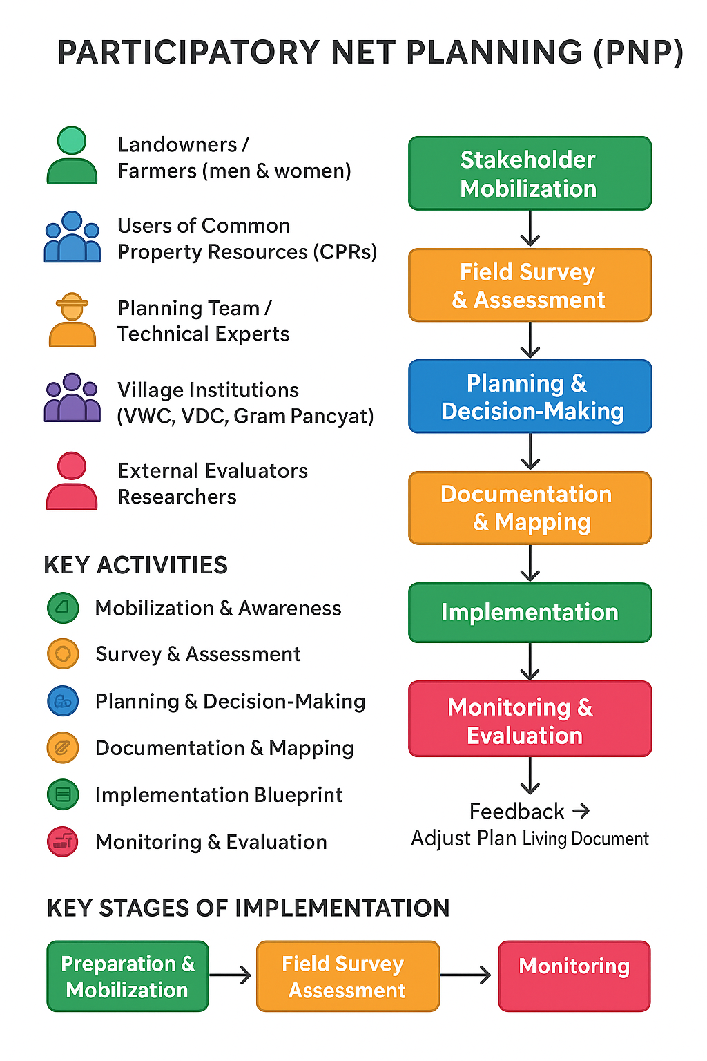
ການອະທິບາຍ:
Flow chart:
The visual summary illustrates the key steps of the PNP approach
Community Mobilization:
Awareness meetings are organized to inform villagers about the purpose of Participatory Net Planning. Local institutions such as the Village Development Committee (VDC), Gram Panchayat (GP), and watershed committees motivate farmers and landowners to participate actively in the process.
Field Assessment:
The planning team, along with landowners and local experts, visits each plot or common property area to study land use, soil condition, slope, and water flow. Existing problems like erosion, poor drainage, or low productivity are identified and discussed on-site.
Participatory Planning:
Stakeholders, including both men and women farmers, jointly decide on the best soil and water conservation measures. Technical experts suggest suitable scientific options, and a consensus is built on feasible and sustainable interventions tailored to each landholding.
Documentation & Implementation:
The agreed plan is documented in simple local language and mapped clearly for each farm or area. Resources such as labor, machinery, and materials are mobilized, and the works are executed under close supervision of technical experts and local committees.
Monitoring & Evaluation:
The progress and quality of work are jointly monitored by the technical team, village committees, and farmers. Periodic evaluations ensure the plan stays relevant, effective, and sustainable, encouraging learning, accountability, and continuous improvement.
ຜູ້ຂຽນ:
Dr. Arun Bhagat
3.4 ການຕັດສິນໃຈກ່ຽວກັບການຄັດເລືອກເຕັກໂນໂລຢີຂອງການຄຸ້ມຄອງທີ່ດິນແບບຍືນຍົງ / ເຕັກໂນໂລຢີ
ລະບຸ ຄົນທີ່ຕັດສິນໃຈ ກ່ຽວກັບການຄັດເລືອກຂອງ ເຕັກໂນໂລຢີ / ເຕັກໂນໂລຢີ ຈະໄດ້ຮັບການປະຕິບັດ:
- ພາກສ່ວນກ່ຽວຂ້ອງທັງໝົດ, ເປັນສ່ວນໜຶ່ງ ຂອງວິທີທາງແບບມີສ່ວນຮ່ວມ
ອະທິບາຍ:
The PNP approach helps identify the current land use and understand the socio-economic conditions linked to it. It aims to improve farmers’ income by suggesting better land use patterns. Technical and agricultural experts play a key role in preparing the proposed land use plan, which is then replicated with other farmers in the village. The village committee is essential for mobilizing and encouraging community participation in this process.
Specify on what basis decisions were made:
- ປະເມີນເອກກະສານ ຄວາມຮູ້ກ່ຽວກັບ ການຄຸ້ມຄອງ ທີ່ດິນແບບຍືນຍົງ (ຫຼັກຖານທີ່ຊ່ວຍໃນການຕັດສິນໃຈ)
- ປະສົບການສ່ວນບຸກຄົນ ແລະ ຄວາມຄິດເຫັນ (ທີ່ບໍ່ເປັນເອກກະສານ)
4. ການສະໜັບສະໜູນທາງດ້ານວິຊາການ, ການສ້າງຄວາມສາມາດ, ແລະ ການຈັດການຄວາມຮູ້.
4.1 ການສ້າງຄວາມສາມາດ / ການຝຶກອົບຮົມ
ຜູ້ນໍາໃຊ້ທີ່ດິນ ຫຼື ພາກສ່ວນກ່ຽວຂ້ອງອື່ນໆ ໄດ້ຮັບການຝຶກອົບຮົມບໍ່?
ແມ່ນ
ໃຫ້ລະບຸ ຜູ້ໃດທີ່ໄດ້ຮັບການຝຶກອົບຮົມ:
- ຜູ້ນໍາໃຊ້ດິນ
- ພະນັກງານພາກສະໜາມ / ທີ່ປຶກສາ
ຮູບແບບຂອງການຝຶກອົບຮົມ:
- ຕົວຕໍ່ຕົວ
- ເນື້ອທີ່ສວນທົດລອງ
- ກອງປະຊຸມ
ໃນຫົວຂໍ້:
Assessment of current land use, classification of land types, and implementation of on-site soil conservation measures.
ຄວາມຄິດເຫັນ:
A joint meeting of multiple landowners is organized to share basic information, followed by a field demonstration in one of the plots to explain the planning tool. Photos and videos of various in-situ soil conservation measures, aligned with the land use and land cover, are also presented.
4.2 ການບໍລິການໃຫ້ຄໍາປຶກສາ
ເຮັດຜູ້ໃຊ້ທີ່ດິນມີການເຂົ້າເຖິງການບໍລິການໃຫ້ຄໍາປຶກສາ?
ແມ່ນ
ລະບຸວ່າການສະໜອງ ການບໍລິການ ໃຫ້ຄໍາປຶກສາ:
- ໃນພື້ນທີ່ຂອງຜູ້ນໍາໃຊ້ດິນ
- ສູນຄົ້ນຄວ້າ
ອະທິບາຍ / ຄວາມຄິດເຫັນ:
The service is provided under the project by the implementing agency. The landowner can develop the land according to requirements with the assistance of a land developer or consultant.
4.3 ສະຖາບັນການສ້າງຄວາມເຂັ້ມແຂງ (ການພັດທະນາອົງການຈັດຕັ້ງ)
ສະຖາບັນ ໄດ້ຮັບການສ້າງຕັ້ງຂື້ນ ຫຼື ໄດ້ຮັບການສ້າງຄວາມເຂັ້ມແຂງ ໂດຍການຈັດຕັ້ງປະຕິບັດ ວິທີທາງບໍ່?
- ມີ, ຫຼາຍ
ລະບຸ ທາງສະຖາບັນ ໄດ້ສ້າງຄວາມເຂັ້ມແຂງ ໃນລະດັບໃດ (ຫຼາຍ):
- ທ້ອງຖິ່ນ
- ລະດັບພາກພື້ນ
ອະທິບາຍ ສະຖາບັນການຈັດຕັ້ງ, ພາລະບົດບາດ ແລະ ໜ້າທີ່ຮັບຜິດຊອບ, ສະມາຊິກ ແລະ ອື່ນໆ.
The planning tool is a socio-technical approach used for sustainable land development. Agricultural engineers, social engineers, and environmental experts from institutions can participate, along with officers from the Forest and Agricultural departments.
ລະບຸ ປະເພດ ຂອງສະໜັບສະໜູນ:
- ທາງດ້ານການເງິນ
- ການສ້າງຄວາມອາດສາມາດ / ການຝຶກອົບຮົມ
4.4 ຕິດຕາມກວດກາ ແລະ ປະເມີນຜົນ
ການຈັດຕັ້ງປະຕິບັດ ວິທີທາງ ໄດ້ມີການປະເມີນຜົນ ແລະ ຕິດຕາມບໍ?
ແມ່ນ
ຄວາມຄິດເຫັນ:
The overall plan is verified on a sample basis to ensure quality and alignment with ground reality.
ຖ້າແມ່ນ, ເອກກະສານສະບັບນີ້ ແມ່ນໄດ້ນໍາໃຊ້ເຂົ້າໃນການຕິດຕາມ ແລະ ປະເມີນຜົນບໍ່?
ແມ່ນ
ຄວາມຄິດເຫັນ:
Field verification shall be conducted based on the prepared planning documents.
4.5 ການຄົ້ນຄວ້າ
ນີ້້ແມ່ນສ່ວນໜຶ່ງ ການຄົ້ນຄວ້າ ຂອງວິທີທາງບໍ່?
ແມ່ນ
ລະບຸ ຫົວຂໍ້:
- ສັງຄົມ
- ເສດຖະສາດ / ການຕະຫຼາດ
- ລະບົບນິເວດ
- ເຕັກໂນໂລຢີ
ໃຫ້ຂໍ້ມູນ ເພີ່ມເຕີມ ແລະ ກໍານົດ ຜູ້ໃດເຮັດການຄົ້ນຄວ້າ:
Experts involved in the planning and implementation of the PNP contribute their experience. While research was not the primary focus, insights gained during community mobilization and watershed plan execution help improve the approach for smoother implementation.
5. ການສະໜັບສະໜູນທາງດ້ານການເງິນ ແລະ ອຸປະກອນຈາກພາຍນອກ
5.1 ງົບປະມານປະຈໍາປີ ສໍາລັບວິທີທາງ ຂອງການຄຸ້ມຄອງ ທີ່ດິນແບບຍືນຍົງ
ຖ້າຫາກບໍ່ຮູ້ຈັດງົບປະມານທີ່ແນ່ນອນ ແມ່ນໃຫ້ປະມານເອົາ:
- < 2,000
ຄໍາເຫັນ (ຕົວຢ່າງ: ແຫຼ່ງຂໍ້ມູນຫຼັກ ຂອງການສະໜອງທຶນ / ຜູ້ໃຫ້ທຶນທີ່ສໍາຄັນ):
The total cost from planning to implementation is measured per hectare and ranges from ₹20,000 to ₹50,000 per hectare, depending on the proposed land use.
5.2 ການສະໜັບສະໜູນ ທາງດ້ານການເງິນ / ອຸປະກອນ ສະໜອງໃຫ້ແກ່ຜູ້ນໍາທີ່ດິນ
ຜູ້ນໍາໃຊ້ດິນ ໄດ້ຮັບການສະໜັບສະໜູນ ທາງດ້ານ ການເງິນ / ອຸປະກອນ ໃນການຈັດຕັ້ງປະຕິບັດ ເຕັກໂນໂລຢີບໍ?
ແມ່ນ
5.3 ເງິນສົມທົບສໍາລັບການນໍາໃຊ້ສະເພາະປັດໃຈຂາເຂົ້າໃນການຜະລີດກະສິກໍາ (ລວມທັງແຮງງານ)
- ບໍ່ມີ
ຖ້າແຮງງານ ຂອງຜູ້ນໍາໃຊ້ດິນ ໄດ້ຮັບການສະໜັບສະໜູນ ປັດໃຈຂາເຂົ້າ, ແມ່ນບໍ່:
- ການອາສາ
5.4 ສິນເຊື່ອ
ໄດ້ປ່ອຍສິນເຊື່ອ ສະໜອງໃຫ້ພາຍໃຕ້ ວິທີການສໍາລັບກິດຈະກໍາ ການຄຸ້ມຄອງ ທີ່ດິນແບບຍືນນຍົງບໍ່?
ບໍ່ແມ່ນ
5.5 ສິ່ງຈູງໃຈ ຫຼື ເຄື່ອງມືອື່ນໆ
ການສົ່ງເສີມ ຈັດຕັ້ງປະຕິບັດ ເຕັກໂນໂລຢີ ໃນການຄຸ້ມຄອງ ດິນແບບຍືນຍົງ ໄດ້ສະໜອງສິ່ງກະຕຸກຊຸກຍູ້ບໍ່?
ບໍ່ແມ່ນ
6. ວິເຄາະຜົນກະທົບ ແລະ ສັງລວມບັນຫາ
6.1 ຜົນກະທົບຂອງແນວທາງ
ວິທີທາງ ຊ່ວຍຊຸກຍູ້ ຜູ້ນຳໃຊ້ທີ່ດິນທ້ອງຖີ່ນ, ໃນການປັບປຸງ ການມີສ່ວນຮ່ວມ ຂອງຜູ້ທີ່ກ່ຽວຂ້ອງ ບໍ່?
- ບໍ່
- ມີ, ໜ້ອຍໜຶ່ງ
- ມີ, ພໍສົມຄວນ
- ມີ, ຫຼາຍ
PNP actively involves local land users in decision-making, joint planning, and management, increasing their sense of ownership and participation in SLM.
ການນໍາໃຊ້ ວິທີທາງ ດັ່ງກ່າວນີ້ ສາມາດເປັນຫຼັກຖານ ທີ່ສະໜັບສະໜູນ ໃຫ້ການຕັດສິນໃຈໄດ້ບໍ່?
- ບໍ່
- ມີ, ໜ້ອຍໜຶ່ງ
- ມີ, ພໍສົມຄວນ
- ມີ, ຫຼາຍ
Mapping of resources, data collection, and participatory analysis enable communities to plan interventions based on evidence.
ການຈັດຕັ້ງປະຕິບັດ ວິທີທາງ ສາມາດຊ່ວຍຜູ້ນໍາໃຊ້ທີ່ດິນ ໃນການຈັດຕັ້ງປະຕິບັດ ແລະ ບໍາລຸງຮັກສາ ເຕັກໂນໂລຢີ ການຄຸ້ມຄອງ ທີ່ດິນແບບຍືນຍົງໄດ້ບໍ?
- ບໍ່
- ມີ, ໜ້ອຍໜຶ່ງ
- ມີ, ພໍສົມຄວນ
- ມີ, ຫຼາຍ
By linking planning with resource availability and community initiatives, PNP ensures successful implementation and sustainability of SLM practices.
ການນໍາໃຊ້ ວິທີທາງ ສາມາດປັບປຸງ ການປະສານງານ ແລະ ຄ່າໃຊ້ຈ່າຍ ການຈັດຕັ້ງປະຕິບັດ ທີ່ມີປະສິດທິພາບ ຂອງການຄຸ້ມຄອງ ທີ່ດິນແບບຍືດຍົງໄດ້ບໍ່?
- ບໍ່
- ມີ, ໜ້ອຍໜຶ່ງ
- ມີ, ພໍສົມຄວນ
- ມີ, ຫຼາຍ
Joint planning and shared responsibilities reduce duplication and optimize resource use.
ການນໍາໃຊ້ ວິທີທາງ ສາມາດລະດົມ ຫຼື ປັບປຸງ ການເຂົ້າເຖິງຊັບພະຍາກອນ ການເງິນ ສໍາລັບການຈັດຕັ້ງປະຕິບັດ ການຄຸ້ມຄອງ ທີ່ດິນແບບຍືດຍົງໄດ້ບໍ່?
- ບໍ່
- ມີ, ໜ້ອຍໜຶ່ງ
- ມີ, ພໍສົມຄວນ
- ມີ, ຫຼາຍ
Communities sometimes access government schemes, subsidies, or microfinance, but PNP primarily facilitates planning rather than direct funding.
ການນໍາໃຊ້ ວິທີທາງ ສາມາດປັບປຸງຄວາມຮູ້ ແລະ ຄວາມສາມາດຂອງຜູ້ນໍາໃຊ້ທີ່ດິນ ໃນການປະຕິບັດ ການຄຸ້ມຄອງ ທີ່ດິນແບບຍືດຍົງໄດ້ບໍ່?
- ບໍ່
- ມີ, ໜ້ອຍໜຶ່ງ
- ມີ, ພໍສົມຄວນ
- ມີ, ຫຼາຍ
Training, workshops, and on-field demonstration under PNP enhance skills and technical knowledge for SLM.
ການນໍາໃຊ້ ວິທີທາງ ສາມາດປັບປຸງຄວາມຮູ້ ແລະ ຄວາມສາມາດ ຂອງພາກສ່ວນທີ່ກ່ຽວຂ້ອງໄດ້ບໍ່?
- ບໍ່
- ມີ, ໜ້ອຍໜຶ່ງ
- ມີ, ພໍສົມຄວນ
- ມີ, ຫຼາຍ
External agencies, NGOs, and local government staff gain insights into community priorities and resource status through PNP processes.
ການນໍາໃຊ້ ວິທີທາງ ສາມາດສ້າງຄວາມເຂັ້ມແຂງ ໃຫ້ສະຖາບັນການຈັດຕັ້ງ, ການຮ່ວມມື ລະຫວ່າງພາກສ່ວນທີ່ກ່ຽວຂ້ອງບໍ່?
- ບໍ່
- ມີ, ໜ້ອຍໜຶ່ງ
- ມີ, ພໍສົມຄວນ
- ມີ, ຫຼາຍ
Formation of watershed committees and joint planning platforms strengthens institutional capacity and collaboration.
ການນໍາໃຊ້ ວິທີທາງ ສາມາດຫຼຸດຜ່ອນ ຂໍ້ຂັດແຍ່ງໄດ້ບໍ່?
- ບໍ່
- ມີ, ໜ້ອຍໜຶ່ງ
- ມີ, ພໍສົມຄວນ
- ມີ, ຫຼາຍ
Participatory discussions and joint decision-making reduce disputes over land, water, and resource use.
ການຈັດຕັ້ງປະຕິບັດ ວິທີທາງ ສາມາດສ້າງຄວາມເຂັ້ມແຂງ ທາງສັງຄົມ ແລະ ເສດຖະກິດບໍ່?
- ບໍ່
- ມີ, ໜ້ອຍໜຶ່ງ
- ມີ, ພໍສົມຄວນ
- ມີ, ຫຼາຍ
Women, landless laborers, and marginalized groups are included in planning and implementation discussions.
ການຈັດຕັ້ງປະຕິບັດ ວິທີທາງ ສາມາດປັບປຸງ ຄວາມສະເໜີພາບ ຂອງບົດບາດ ຍິງຊາຍ ແລະ ສ້າງຄວາມເຂັ້ມແຂງໃຫ້ຜູ້ຍິງໄດ້ບໍ່?
- ບໍ່
- ມີ, ໜ້ອຍໜຶ່ງ
- ມີ, ພໍສົມຄວນ
- ມີ, ຫຼາຍ
Women’s participation in committees and field activities increases their voice in SLM decisions.
ການຈັດຕັ້ງປະຕິບັດ ວິທີທາງ ສາມາດຊຸກຍູ້ ຜູ້ນໍາໃຊ້ທີ່ດິນທີ່ເປັນຊາວໜຸ່ມ / ຄົນລຸ້ນໃໝ່ ໃນການຄຸ້ມຄອງ ທີ່ດິນແບບຍືນຍົງໄດ້ບໍ?
- ບໍ່
- ມີ, ໜ້ອຍໜຶ່ງ
- ມີ, ພໍສົມຄວນ
- ມີ, ຫຼາຍ
Young people are involved in field activities and awareness campaigns, though engagement varies by context.
ການຈັດຕັ້ງປະຕິບັດ ວິທີທາງ ສາມາດປັບປຸງ ປະເດັນການຖືຄອງທີ່ດິນ / ສິດທິໃນການນໍາໃຊ້ທີ່ດິນ ທີ່ເຊື່ອງຊ້ອນໃນການຈັດຕັ້ງປະຕິບັດ ເຕັກໂນໂລຢີ ການຄຸ້ມຄອງ ທີ່ດິນແບບຍືນຍົງໄດ້ບໍ?
- ບໍ່
- ມີ, ໜ້ອຍໜຶ່ງ
- ມີ, ພໍສົມຄວນ
- ມີ, ຫຼາຍ
Some improvements occur through awareness and participatory planning, but structural tenure issues may persist.
ການນໍາໃຊ້ ວິທີທາງ ໄດ້ປັບປຸງ ການຄໍ້າປະກັນສະບຽງອາຫານ ຫຼື ປັບປຸງໂຄສະນາການໄດ້ບໍ່?
- ບໍ່
- ມີ, ໜ້ອຍໜຶ່ງ
- ມີ, ພໍສົມຄວນ
- ມີ, ຫຼາຍ
Soil and water conservation, improved cropping systems, and better land management contribute to higher productivity and food security.
ການຈັດຕັ້ງປະຕິບັດ ວິທີທາງ ສາມາດປັບປຸງ ການເຂົ້າເຖິງຕະຫຼາດໄດ້ບໍ?
- ບໍ່
- ມີ, ໜ້ອຍໜຶ່ງ
- ມີ, ພໍສົມຄວນ
- ມີ, ຫຼາຍ
Some linkages are developed for crops or produce through collective action, though not a primary focus of PNP.
ການນໍາໃຊ້ ວິທີທາງ ໄດ້ປັບປຸງ ການເຂົ້າເຖິງນໍ້າ ແລະ ສາຂາພິບານໄດ້ບໍ່?
- ບໍ່
- ມີ, ໜ້ອຍໜຶ່ງ
- ມີ, ພໍສົມຄວນ
- ມີ, ຫຼາຍ
Watershed interventions and resource management improve local water availability; sanitation benefits are indirect.
ການນໍາໃຊ້ ວິທີທາງ ໄດ້ປັບປຸງ ການນໍາໃຊ້ແຫຼ່ງພະລັງງານ ແບບຍືນຍົງຫຼາຍຂື້ນບໍ່?
- ບໍ່
- ມີ, ໜ້ອຍໜຶ່ງ
- ມີ, ພໍສົມຄວນ
- ມີ, ຫຼາຍ
Limited impact through promotion of fuelwood plantations or energy-efficient practices.
ການຈັດຕັ້ງປະຕິບັດ ວິທີທາງ ສາມາດສ້າງຄວາມອາດສາມາດໃຫ້ຜູ້ນໍາໃຊ້ດິນ ໃນການປັບຕົວ ຕໍ່ການປ່ຽນແປງດິນຟ້າອາກາດ / ຫຼດຜ່ອນຄວາມສ່ຽງທາງໄພພິບັດໄດ້ບໍ? :
- ບໍ່
- ມີ, ໜ້ອຍໜຶ່ງ
- ມີ, ພໍສົມຄວນ
- ມີ, ຫຼາຍ
Improved soil and water management, vegetation cover, and participatory planning increase resilience to droughts and floods.
ການນໍາໃຊ້ ວິທີທາງ ໄດ້ປັບປຸງ ການຈ້າງງານ, ໂອກາດ ໃນການສ້າງລາຍຮັບບໍ່?
- ບໍ່
- ມີ, ໜ້ອຍໜຶ່ງ
- ມີ, ພໍສົມຄວນ
- ມີ, ຫຼາຍ
Implementation of SLM activities creates temporary work and improves productivity, indirectly supporting income generation.
6.2 ແຮງຈູງໃຈຫຼັກຂອງຜູ້ນໍາໃຊ້ທີ່ດິນໃນການປະຕິບັດການຄຸ້ມຄອງທີ່ດິນແບບຍືນຍົງ
- ການຜະລິດເພີ່ມຂຶ້ນ
Quality and appropriate interventions enhance soil fertility and increase productivity.
- ຫຼຸດຜ່ອນດິນເຊື່ອມໂຊມ
Proper land management and increased tree cover help reduce surface runoff.
- ຫຼຸດຜ່ອນຄວາມສ່ຽງຂອງໄພພິບັດ
Proper land management helps reduce the risks of drought and flooding.
- ການປັບປຸງ ຄວາມຮູ້ ແລະ ຄວາມສາມາດ ຂອງການຄຸ້ມຄອງ ທີ່ດິນແບບຍືນຍົງ
PNP is a participatory planning process that facilitates the exchange of ideas.
6.3 ຄວາມຍືນຍົງຂອງກິດຈະກໍາວິທີທາງ
ຜູ້ນໍາໃຊ້ ທີ່ດິນ ສາມາດສືບຕໍ່ ການຈັດຕັ້ງປະຕິບັດ ຜ່ານວິທີທາງໄດ້ບໍ່ (ໂດຍປາດສະຈາກ ການຊ່ວຍເຫຼືອ ຈາກພາກສ່ວນພາຍນອກ)?
- ແມ່ນ
ຖ້າ ໄດ້, ອະທິບາຍເຫດຜົນ:
Land users can sustain the interventions implemented through the PNP approach without external support, provided they have gained adequate knowledge, skills, and ownership during the participatory planning process. The focus on locally appropriate techniques, use of available resources, and community involvement ensures long-term sustainability.
6.4 ຈຸດແຂງ / ຂໍ້ດີ ຂອງວິທີທາງ
| ຈຸດແຂງ / ຂໍ້ດີ / ໂອກາດໃນການນໍາໃຊ້ທີ່ດິນ |
|---|
| Participatory Decision-Making: Land users actively contribute ideas and decisions, ensuring the plan reflects their needs and priorities. |
| Improved Knowledge: Farmers gain practical knowledge about soil, land use, and conservation techniques. |
| Sustainable Land Management: Encourages adoption of site-specific, in-situ conservation measures that improve soil fertility and productivity. |
| Livelihood Opportunities: Identifies farm-based income options, such as dairy, fodder production, and agroforestry. |
| Resource Optimization: Promotes efficient use of local resources like stones, bushes, and organic matter. |
| Conflict Reduction: Helps mitigate disputes over land boundaries and reduces encroachments. |
| Empowerment: Strengthens community organization and gives women and marginalized groups more decision-making opportunities. |
| Long-Term Benefits: Supports soil moisture retention, biomass production, and water conservation, leading to resilient agriculture. |
| ຈຸດແຂງ / ຈຸດດີ / ໂອກາດ ຈາກທັດສະນະຂອງຜູ້ປ້ອນຂໍ້ມູນ ຫຼື ບຸກຄົນສຳຄັນ |
|---|
| Effective Planning Tool: Provides a structured framework for assessing land, soil, and resources scientifically. |
| Community Engagement: Facilitates active participation of landowners, enhancing acceptance and ownership of interventions. |
| Integrated Approach: Combines technical, social, and environmental considerations for sustainable land management. |
| Field-Oriented Learning: Allows experts to demonstrate techniques and observe practical challenges. |
| Sustainability Focus: Encourages adoption of low-cost, locally suitable interventions that are maintainable without continuous external support. |
| Conflict Mitigation: Helps in discussing land disputes and clarifying boundaries. |
| Scalable & Replicable: Can be applied across multiple fields or villages for wider impact. |
6.5 ຈຸດອ່ອນ / ຂໍ້ເສຍຂອງແນວທາງ ແລະ ວິທີການແກ້ໄຂໃຫ້ເຂົາເຈົ້າ
| ຈຸດອ່ອນ / ຂໍ້ເສຍ / ຄວາມສ່ຽງໃນມູມມອງຂອງຜູ້ນໍາໃຊ້ທີ່ດິນ | ມີວິທີການແກ້ໄຂຄືແນວໃດ? |
|---|---|
| Time-Consuming: Participatory meetings and field exercises require considerable time. | Time Management: Schedule meetings and demonstrations at convenient times for farmers. |
| Resource Dependence: Initial implementation may need materials or guidance not readily available to all farmers. | Local Resource Use: Emphasize low-cost, locally available materials for interventions. |
| Knowledge Gap: Some farmers may initially struggle to understand technical aspects. | Capacity Building: Provide training and simple demonstration tools to bridge technical knowledge gaps. |
| Group Dynamics: Conflicts or dominant voices within the group may affect decision-making. | Facilitation: Use neutral facilitators to manage group discussions and ensure all voices are heard. |
| Maintenance Challenges: Sustaining interventions over time without support can be difficult for some households. | Follow-Up Support: Provide periodic guidance and monitoring to help farmers maintain interventions. |
| ຈຸດອ່ອນ ຫຼື ຂໍ້ເສຍ ຫຼື ຄວາມສ່ຽງ ໃນມຸມມອງຂອງ ຜູ້ສັງລວມຂໍ້ມູນ ຫຼື ບັນດາຜູ້ຕອບແບບສອບຖາມ | ມີວິທີການແກ້ໄຂຄືແນວໃດ? |
|---|---|
| Time-Intensive: Participatory planning and field exercises require significant time and effort. | Efficient Scheduling: Plan activities to minimize disruption to farmers’ regular work. |
| Dependence on Community Cooperation: Effectiveness relies on active participation and willingness of land users. | Capacity Building: Train community members to enhance understanding and technical competence. |
| Limited Technical Precision: Field-level decisions may sometimes compromise scientific accuracy due to local constraints. | Facilitation & Guidance: Experts guide discussions to balance local preferences with technical requirements. |
| Resource Limitations: Availability of tools, inputs, or skilled manpower may restrict implementation. | Resource Planning: Ensure access to necessary inputs and tools before implementation. |
| Monitoring Challenges: Ensuring long-term adherence to recommended interventions can be difficult. | Follow-Up Mechanisms: Establish monitoring and support systems for sustained adoption. |
7. ເອກກະສານອ້າງອີງ ແລະ ຂໍ້ມູນການເຊື່ອມໂຍງ
7.1 ວິທີການ / ແຫຼ່ງຂໍ້ມູນ
- ການໄປຢ້ຽມຢາມພາກສະໜາມ, ການສໍາຫຼວດພາກສະໜາມ
Visited the field twice and gathered information from a community group of 7–8 people.
- ການສໍາພາດ ຜູ້ນໍາໃຊ້ທີ່ດິນ
Interviews were conducted with six land users.
- ສໍາພາດ ຊ່ຽວຊານ ການຄຸ້ມຄອງ ດິນແບບຍືນຍົງ
Interviews were conducted with 4 SLM specialist/experts.
- ການລວບລວມ ບົດລາຍງານ ແລະ ເອກະສານອື່ນໆ ທີ່ມີຢູ່ແລ້ວ
Information was obtained from the Participatory Net Planning (PNP) book authored by Crispino Lobo (WOTR) and from Watershed Organisation Trust (WOTR) reports and publications (https://wotr.org/publications).
7.2 ເອກະສານທົ່ວໄປທີ່ສາມາດໃຊ້ໄດ້
ຫົວຂໍ້, ຜູ້ຂຽນ, ປີ, ISBN:
Participatory Net Planning: A Practitioner's Handbook, authored by Crispino Lobo. 2010. ISBN: 978-81-86748-23-7 [Supported by: German Agency for Technical Cooperation (GTZ)]
ມີຢູ່ໃສ?ມູນຄ່າເທົ່າໃດ?
https://wotr.org/wp-content/uploads/2025/10/WOTR-PNP-Practitioners-Handbook.pdf
7.3 ການເຊື່ອມຕໍ່ກັບຂໍ້ມູນທີ່ກ່ຽວຂ້ອງທີ່ສາມາດໃຊ້ອອນໄລນ໌
ຫົວຂໍ້ / ພັນລະນາ:
Participatory Net Planning (PNP)
URL:
https://www.youtube.com/watch?v=dU9dSJUgIQM
ຫົວຂໍ້ / ພັນລະນາ:
How to do Participatory Net planning
URL:
https://www.youtube.com/watch?v=qGom-qA_be4
ຫົວຂໍ້ / ພັນລະນາ:
How to do Micro planning in Watershed Project
URL:
https://www.youtube.com/watch?v=BDOKQBfcg-0
ຫົວຂໍ້ / ພັນລະນາ:
Rising Together: Building Resilient Communities for a Sustainable Tomorrow
URL:
https://www.youtube.com/watch?v=0gCFkwkfwdg&t=2s
ຫົວຂໍ້ / ພັນລະນາ:
How to do Wealth Ranking in Watershed Project
URL:
https://www.youtube.com/watch?v=ygiAy7f7Gpc
ຫົວຂໍ້ / ພັນລະນາ:
Integrated Watershed Management in Sinnar cluster, Nashik district, Maharashtra, India
URL:
https://www.youtube.com/watch?v=9HfP20wucnE&t=3s
ຫົວຂໍ້ / ພັນລະນາ:
A New Beginning
URL:
https://www.youtube.com/watch?v=LBzF7DXbedM&t=2s
ຂໍ້ມູນການເຊື່ອມຕໍ່ ແລະ ເນື້ອໃນ
ຂະຫຍາຍທັງໝົດ ຍຸບທັງໝົດການເຊື່ອມຕໍ່
ບໍ່ມີຂໍ້ມູນການເຊື່ອມຕໍ່
ເນື້ອໃນ
ບໍ່ມີເນື້ອໃນ