Contour trenches and contour strips [ອູເບກີສຖານ]
- ການສ້າງ:
- ປັບປູງ:
- ຜູ້ສັງລວມຂໍ້ມູນ: Joren Verbist
- ບັນນາທິການ: –
- ຜູ້ທົບທວນຄືນ: William Critchley, Rima Mekdaschi Studer
technologies_7557 - ອູເບກີສຖານ
ເບິ່ງພາກສ່ວນ
ຂະຫຍາຍທັງໝົດ ຍຸບທັງໝົດ1. ຂໍ້ມູນທົ່ວໄປ
1.2 ຂໍ້ມູນ ການຕິດຕໍ່ພົວພັນ ຂອງບຸກຄົນທີ່ສໍາຄັນ ແລະ ສະຖາບັນ ທີ່ມີສ່ວນຮ່ວມ ໃນການປະເມີນເອກກະສານ ເຕັກໂນໂລຢີ
Senior Scientist Sustainable Land Management:
Akramkhanov Akmal
International Center of Agriculture Research in the Dry Areas (ICARDA)
ອູເບກີສຖານ
Crop Specialist:
Fayzullayev Abdulla
International Center of Agriculture Research in the Dry Areas (ICARDA)
ອູເບກີສຖານ
Water Harvesting Expert:
Muddaber Mohammad Ali
International Center of Agriculture Research in the Dry Areas (ICARDA)
ຈໍແດນ
Water Harvesting Expert:
Jafar Alwidyan
International Center of Agriculture Research in the Dry Areas (ICARDA)
ຈໍແດນ
ຊື່ໂຄງການ ທີ່ອໍານວຍຄວາມສະດວກ ໃນການສ້າງເອກກະສານ/ປະເມີນ ເຕັກໂນໂລຢີ (ຖ້າກ່ຽວຂ້ອງ)
ICARDA Institutional Knowledge Management Initiative1.3 ເງື່ອນໄຂ ກ່ຽວກັບ ການນໍາໃຊ້ຂໍ້ມູນເອກະສານ ທີ່ສ້າງຂື້ນ ໂດຍຜ່ານ ອົງການພາບລວມຂອງໂລກ ທາງດ້ານແນວທາງ ແລະ ເຕັກໂນໂລຢີ ຂອງການອານຸລັກ ທໍາມະຊາດ (WOCAT)
ຜູ້ປ້ອນຂໍ້ມູນ ແລະ ບຸກຄົນສຳຄັນ ທີ່ໃຫ້ຂໍ້ມູນ (ຫຼາຍ) ຍິນຍອມ ຕາມເງື່ອນໄຂ ໃນການນຳໃຊ້ຂໍ້ມູນ ເພື່ອສ້າງເປັນເອກກະສານຂອງ WOCAT:
ແມ່ນ
1.4 ແຈ້ງການວ່າ ດ້ວຍຄວາມຍືນຍົງຂອງ ເຕັກໂນໂລຢີ
ການນໍາໃຊ້ ເຕັກໂນໂລຢີ ດັ່ງກ່າວໄດ້ອະທິບາຍ ເຖິງບັນຫາ ກ່ຽວກັບ ການເຊື່ອມໂຊມຂອງດິນບໍ? ຖ້າບໍ່ດັ່ງນັ້ນ ມັນບໍ່ສາມາດ ຢັ້ງຢືນໄດ້ວ່າ ເປັນເຕັກໂນໂລຊີ ໃນການຄຸ້ມຄອງ ທີ່ດິນແບບຍືນຍົງ? :
ບໍ່ແມ່ນ
2. ການອະທິບາຍ ເຕັກໂນໂລຢີ ຂອງການຄຸ້ມຄອງ ທີ່ດິນແບບຍືນຍົງ
2.1 ຄໍາອະທິບາຍສັ້ນຂອງ ເຕັກໂນໂລຢີ
ການກຳໜົດຄວາມໝາຍ ຂອງເຕັກໂນໂລຢີ:
Contour trenches for the cultivation of almond trees, and contour strips for cereals are types of rainwater harvesting structures. They are designed to capture runoff, reduce erosion, and enhance soil moisture—thereby improving land productivity and supporting climate-resilient agriculture in lowland dry areas.
2.2 ການອະທິບາຍ ລາຍລະອຽດ ຂອງເຕັກໂນໂລຢີ
ການພັນລະນາ:
Qashqadaryo Province in southern Uzbekistan experiences a hot, dry summer and a mild winter. Combined with unsustainable land management practices, climatic stresses have exacerbated land degradation and made local livelihoods increasingly vulnerable.
As part of the Food Systems, Land Use and Restoration (FOLUR) project, the International Center for Agricultural Research in the Dry Areas (ICARDA) designed and tested rainwater harvesting (RWH) structures to combat land degradation and enhance rural livelihoods. These RWH structures support vegetation growth, reduce surface runoff, prevent erosion, and restore soil health—thereby reversing degradation and improving agricultural productivity.
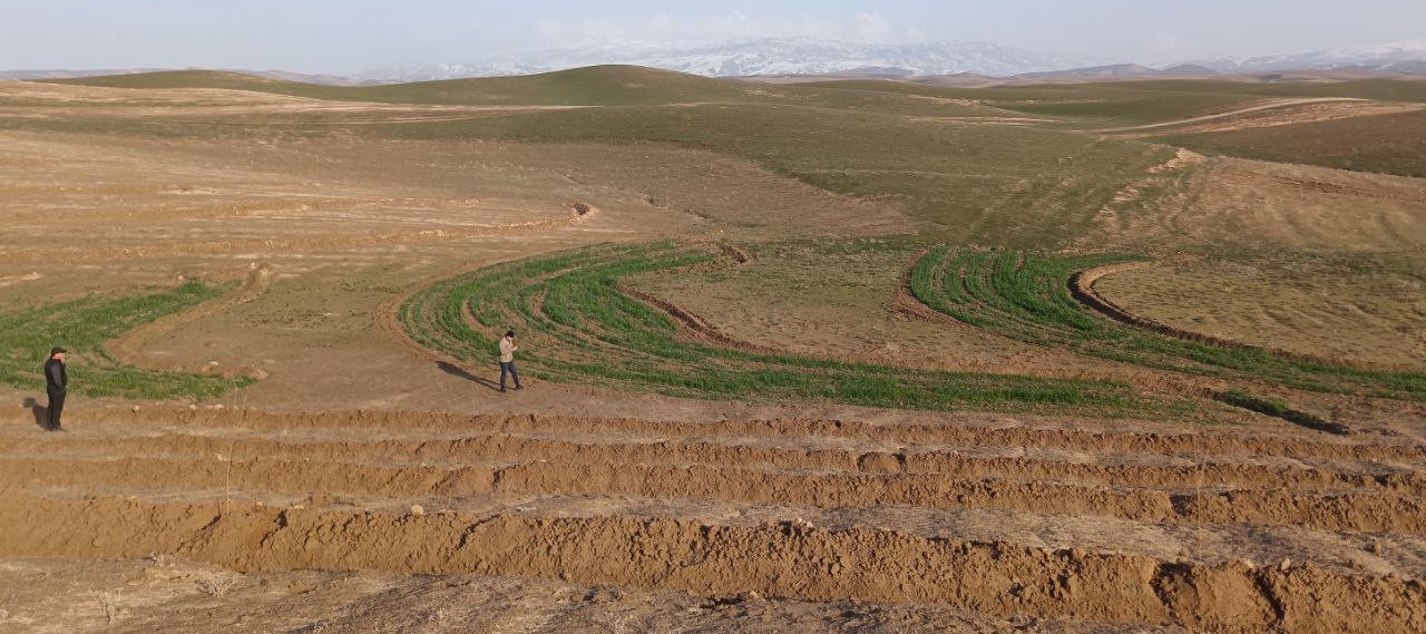
Based on slope gradients and hydrological characteristics, two RWH techniques were selected: modified contour trenches for the slightly sloping upper areas, and modified contour strips for the flatter zones.
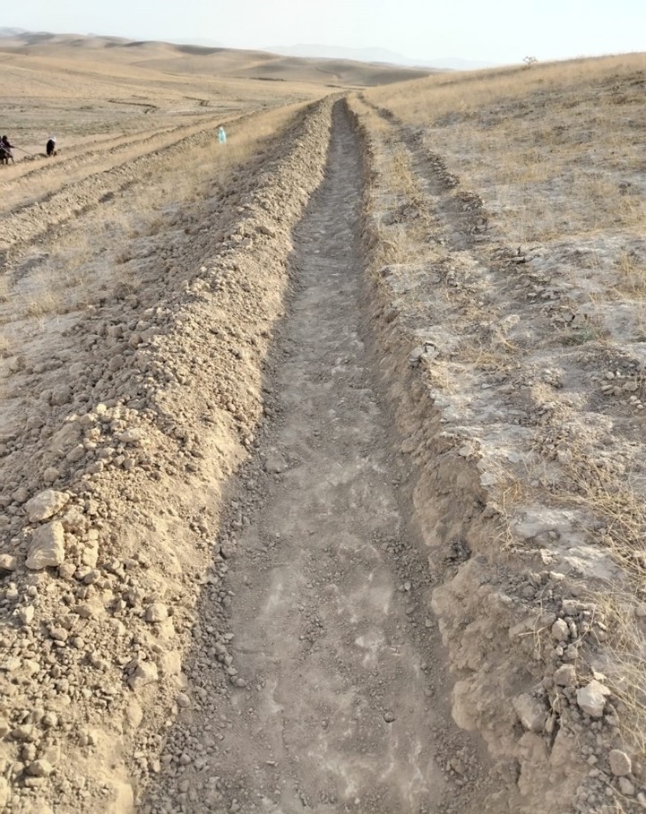
In the upper portion of the site, which spans 1.54 hectares, modified contour trenches were implemented for perennial tree crops. Design calculations suggested a spacing of 8 metres between trenches, and 7 metres between almond trees along each trench.
Implementation began with the marking of contour lines using a laser level: two labourers worked for two days. Then a tractor fitted with a three-mouldboard plough dug the trenches. While the tractor generally performed well, work had to be completed manually at sharp bends and gully crossings. Eight labourers then spent two days shaping and stabilizing the trenches. In total, approximately 1,300 metres of trench lines were created.
Costs were relatively modest. The tractor, hired from a farmer, cost $150 per day. Manual labour amounted to 24 person-days at $10 per day. 100 almond trees were planted, and 85 tamarix trees were added as a protective windbreak.
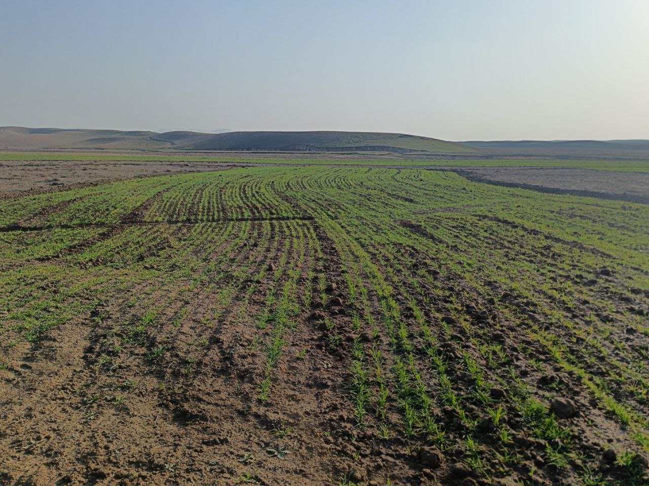
In the lower, flatter part of the site—about 1.68 hectares—standard contour strips were unsuitable due to the very low slope, which would not generate enough runoff. Instead, a modified version was implemented. Low ridges along contour at a vertical interval of 30 cm, allowed rainwater to pool and infiltrate. The same tractor was used with a single mouldboard plough to form nine contour ridges, shaped by two passes.
Afterwards, ten local women labourers finalized the ridges manually. The total length of the contour strips reached 500 metres, and the ratio of catchment to cultivated area varied from 5:1 in the upper sections to 1:1 in the lower zones, based on expected runoff.
The cost of this phase included one day of tractor use and 15 person-days of labour, totalling approximately $300. This site is intended for rainfed cultivation, and will follow a crop rotation system including barley, legumes and fallow periods. Over time, farmers are encouraged to adopt no-till practices to improve soil health.
Following implementation, light rainfall provided a test of the structures. Both the contour trenches and strips performed as intended, with no damage observed.
The interventions demonstrate how a tailored combination of RWH structures and cropping systems can rehabilitate degraded land. Local involvement helped to build community ownership. The result is a more productive and climate-resilient landscape that offers long-term benefits for soil conservation and rural livelihoods.
2.3 ຮູບພາບຂອງເຕັກໂນໂລຢີ
ສື່ຮູບພາບ
2.5 ປະເທດ / ເຂດ / ສະຖານທີ່ບ່ອນທີ່ ເຕັກໂນໂລຢີ ໄດ້ຮັບການນໍາໃຊ້ ແລະ ທີ່ຖືກປົກຄຸມດ້ວຍການປະເມີນຜົນ
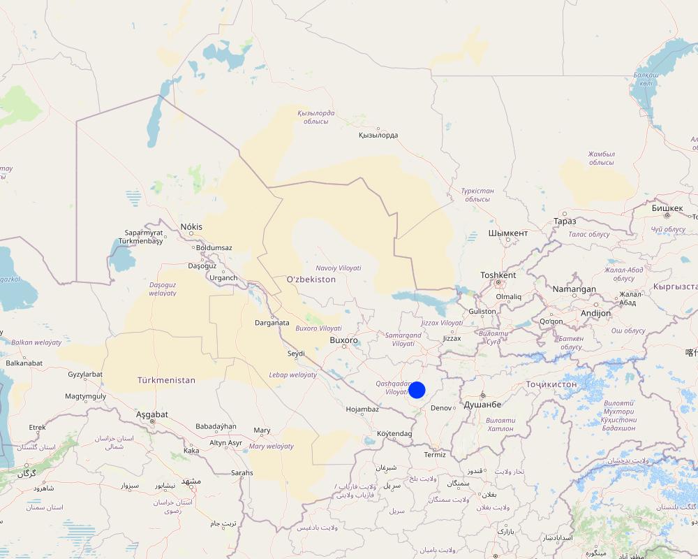
ປະເທດ:
ອູເບກີສຖານ
ຂໍ້ມູນເພີ່ມເຕີມຂອງສະຖານທີ່:
8°43'14.26"N, 66°41'51.87"E
ໃຫ້ລະບຸ ການແຜ່ຂະຫຍາຍ ເຕັກໂນໂລຢີ:
- ແຜ່ຂະຫຍາຍຢ່າງໄວວາໃນພື້ນທີ່
ຖ້າຫາກບໍ່ຮູ້ເນື້ອທີ່ທີ່ແນ່ນອນ, ໃຫ້ລະບຸ ເນື້ອທີ່ໂດຍປະມານ ທີ່ໃກ້ຄຽງ:
- < 0.1 ກິໂລແມັດ2 (10 ເຮັກຕາ)
ສ່ວນຫຼາຍສະຖານທີ່ຕັ້ງຂອງເຕັກໂນໂລຢີ ແມ່ນ ຢູ່ໃນເຂດພື້ນທີ່ສະຫງວນບໍ?
ບໍ່ແມ່ນ
Map
×2.6 ວັນທີໃນການຈັດຕັ້ງປະຕິບັດ
ໃຫ້ລະບຸປີ ໃນການຈັດຕັ້ງປະຕິບັດ:
2024
2.7 ການນໍາສະເໜີ ເຕັກໂນໂລຢີ
ໃຫ້ລະບຸ ເຕັກໂນໂລຢີ ໄດ້ຖືກຈັດຕັ້ງປະຕິບັດຄືແນວໃດ?
- ໂດຍຜ່ານໂຄງການ / ການຊ່ວຍເຫຼືອຈາກພາຍນອກ
3. ການໃຈ້ແຍກ ເຕັກໂນໂລຢີ ໃນການຄຸ້ມຄອງ ດິນແບບຍືນຍົງ
3.1 ຈຸດປະສົງຫຼັກ (ຫຼາຍ) ຂອງເຕັກໂນໂລຢີ
- ປັບປຸງ ການຜະລິດ
- ຫຼຸດຜ່ອນ, ປ້ອງກັນ, ຟື້ນຟູ ການເຊື່ອມໂຊມຂອງດິນ
- ປັບຕົວຕໍ່ກັບການປ່ຽນແປງດິນຟ້າອາກາດ / ທີ່ຮ້າຍແຮງ ແລະ ຜົນກະທົບ
- ສ້າງຜົນກະທົບ ທາງເສດຖະກິດ ທີ່ເປັນປະໂຫຍດ
- ສ້າງຜົນກະທົບ ທີ່ເປັນທາງບວກ ໃຫ້ແກ່ສັງຄົມ
3.2 ປະເພດການນໍາໃຊ້ທີ່ດິນ ໃນປະຈຸບັນ() ທີ່ເຕັກໂນໂລຢີ ໄດ້ຖືກນໍາໃຊ້
ການນຳໃຊ້ທີ່ດິນ ປະສົມພາຍໃນພື້ນທີ່ດຽວກັນ:
ບໍ່ແມ່ນ

ດິນທີ່ປູກພືດ
- ການປູກພືດປະຈໍາປີ
- ພືດຢືນຕົ້ນ (ບໍ່ແມ່ນໄມ້)
ການປູກພືດປະຈຳປີ - ລະບຸປະເພດພືດ:
- ທັນຍາພືດ-ເຂົ້າບາເລ້
- Nuts/ fruits including almonds
ຈໍານວນ ລະດູການ ປູກໃນປີໜຶ່ງ:
- 1
ມີການເຝືກປູກພືດແບບສັບຫວ່າງບໍ່?
ບໍ່ແມ່ນ
ມີການເຝືກປູກພືດແບບໝູນວຽນບໍ່?
ແມ່ນ
ຖ້າແມ່ນ, ໃຫ້ລະບຸແຈ້ງ:
Barley, legumes etc
ຄວາມຄິດເຫັນ:
Note fruits/ nuts on one part of the land and cereals/ legumes/ fodder on another section (see 2.2)
3.3 ການນຳໃຊ້ທີ່ດິນ ມີການປ່ຽນແປງຍ້ອນການຈັດຕັ້ງທົດລອງເຕັກໂນໂລຢີ ແມ່ນບໍ່?
ການນຳໃຊ້ທີ່ດິນ ມີການປ່ຽນແປງຍ້ອນການຈັດຕັ້ງທົດລອງເຕັກໂນໂລຢີ ແມ່ນບໍ່?
- ແມ່ນ (ກະລຸນາຕື່ມໃສ່ ຄຳຖາມຂ້າງລຸ່ມນີ້ກ່ຽວກັບການນຳໃຊ້ທີ່ດິນ ກ່ອນການທົດລອງເຕັກໂນໂລຢີ)
ການນຳໃຊ້ທີ່ດິນ ປະສົມພາຍໃນພື້ນທີ່ດຽວກັນ:
ບໍ່ແມ່ນ

ທົ່ງຫຍ້າລ້ຽງສັດ
ການລ້ຽງສັດແບບປ່ອຍ ຕາມທຳມະຊາດ:
- ການລ້ຽງສັດແບບເຄີ່ງປ່ອຍ
- Mixed
3.4 ການສະໜອງນ້ຳ
ການສະໜອງນໍ້າ ໃນພື້ນທີ່ ທີ່ໄດ້ນໍາໃຊ້ ເຕັກໂນໂລຢີ:
- ນໍ້າຝົນ
3.5 ການນໍາໃຊ້ເຕັກໂນໂລຢີ ທີ່ຢູ່ໃນກຸ່ມການຄຸ້ມຄອງ ທີ່ດິນແບບຍືນຍົງ
- ການປັບປຸງດິນ / ພືດຄຸມດິນ
- ມາດຕະການ ຕັດຂວາງ ກັບຄວາມຄ້ອຍຊັນ
- ການເກັບກັກນໍ້າ
3.6 ມາດຕະການ ການຄຸ້ມຄອງ ທີ່ດິນແບບຍືນຍົງ ປະກອບດ້ວຍ ເຕັກໂນໂລຢີ

ມາດຕະການ ທາງການກະສິກໍາ
- A1: ພືດ / ການປົກຫຸ້ມຂອງດິນ
- A3: ການບໍາລຸງຮັກສາຊັ້ນໜ້າດິນ
- A4: ການບໍາລຸງ ປົກປັກຮັກສາ ຊັ້ນຮອງໜ້າດິນ

ມາດຕະການ ທາງດ້ານພືດພັນ
- V1: ເປັນໄມ້ຢືນຕົ້ນ ແລະ ການປົກຫຸ້ມຂອງໄມ້ພຸ່ມ

ມາດຕະການໂຄງສ້າງ
- S1: ພັກຄັນໃດ
- S2: ຄັນຄຸ, ແຄມຕາຝັ່ງ
- S3: ຮ່ອງ, ຄອງນໍ້າ, ທາງໄຫຼນໍ້າ
- S7: ອຸປະກອນເກັບຮັກສາ, ສະໜອງນ້ຳ, ຊົນລະປະທານ

ມາດຕະການ ທາງດ້ານການຄຸ້ມຄອງ
- M1: ການປ່ຽນແປງ ປະເພດ ການນໍາໃຊ້ທີ່ດິນ
3.7 ປະເພດດິນເຊື່ອມໂຊມ ຫຼັກທີ່ໄດ້ນໍາໃຊ້ ເຕັກໂນໂລຢີ

ດິນເຊາະເຈື່ອນ ໂດຍນໍ້າ
- Wt: ການສູນເສຍຊັ້ນໜ້າດິນ / ການເຊາະເຈື່ອນຜິວໜ້າດິນ
- Wg: ການເຊາະເຈື່ອນຮ່ອງນ້ຳ / ຫ້ວຍ
- Wo: ຜົນກະທົບ ຂອງການເຊື່ອມໂຊມ ຕໍ່ພື້ນທີ່ພາຍນອກ

ດິນເຊາະເຈື່ອນ ໂດຍລົມ
- ການສູນເສຍຊັ້ນໜ້າດິນ
- Ed: ການສູນເສຍຈາກລົມ ແລະ ການທັບຖົມ
- Eo: ຜົນກະທົບຈາກການເຊື່ອມໂຊມທາງອ້ອມ

ການເຊື່ອມໂຊມ ຂອງດິນ ທາງກາຍະພາບ
- Pc: ການອັດແໜ້ນ
- Pk: ການບັນເທົາ ແລະ ການປົກຄຸມຂອງເປືອກໂລກ

ການເຊື່ອມໂຊມ ທາງຊີວະພາບ
- Bc: ການຫຼຸດຜ່ອນການປົກຫຸ້ມຂອງພືດ
- Bq: ປະລິມານ / ອິນຊີວັດຖຸຫຼຸດລົງ
- Bl: ການສູນເສຍ ຈຸລິນຊີໃນດິນ
3.8 ການປ້ອງກັນ, ການຫຼຸດຜ່ອນ, ຫຼືການຟື້ນຟູຂອງການເຊື່ອມໂຊມຂອງດິນ
ໃຫ້ລະບຸ ເປົ້າໝາຍ ເຕັກໂນໂລຢີ ທີ່ພົວພັນ ກັບຄວາມເຊື່ອມໂຊມຂອງດິນ:
- ຫຼຸດຜ່ອນການເຊື່ອມໂຊມຂອງດິນ
- ການຟື້ນຟູ / ຟື້ນຟູດິນທີ່ຊຸດໂຊມ
4. ຂໍ້ກໍາໜົດ, ກິດຈະກໍາການປະຕິບັດ, ວັດຖຸດິບ, ແລະຄ່າໃຊ້ຈ່າຍ
4.1 ເຕັກນິກ ໃນການແຕ້ມແຜນວາດ ເຕັກໂນໂລຢີ
ຄຸນລັກສະນະ ຂອງເຕັກນິກ (ທີ່ກ່ຽວຂ້ອງ ກັບການແຕ້ມແຜນວາດ ທາງດ້ານເຕັກນີກ):
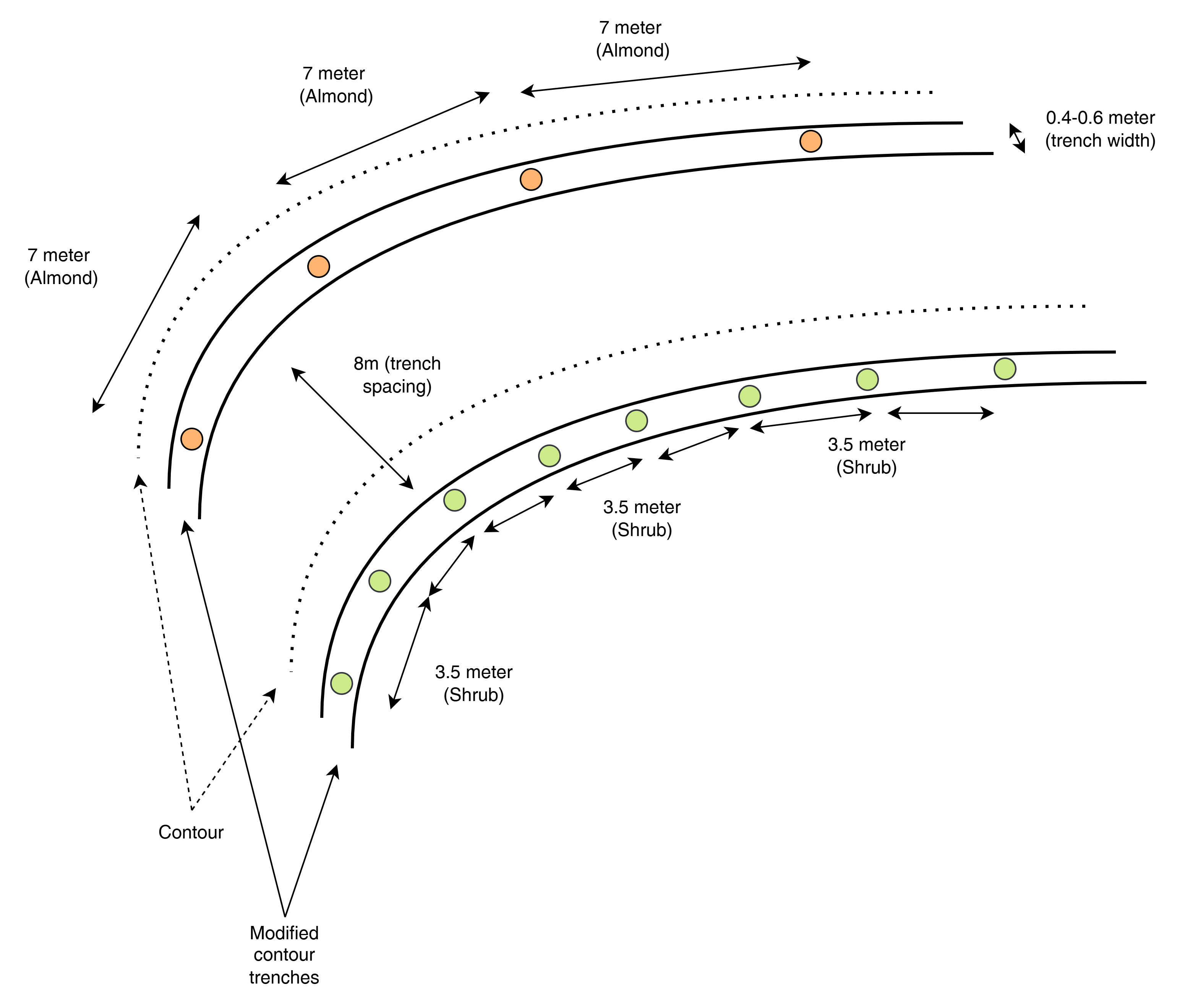
This top-view diagram shows the layout of modified contour trenches along contour lines, spaced 8 meters apart vertically. Each trench supports either:
Almond trees, spaced 7 meters apart, or
Shrubs, spaced 3.5 meters apart.
Each trench is aligned to follow the natural contour of the land to intercept runoff and enhance infiltration. Shrubs and trees are planted separately in designated trenches, not mixed.
ຜູ້ຂຽນ:
ICARDA
ວັນທີ:
2025
ຄຸນລັກສະນະ ຂອງເຕັກນິກ (ທີ່ກ່ຽວຂ້ອງ ກັບການແຕ້ມແຜນວາດ ທາງດ້ານເຕັກນີກ):
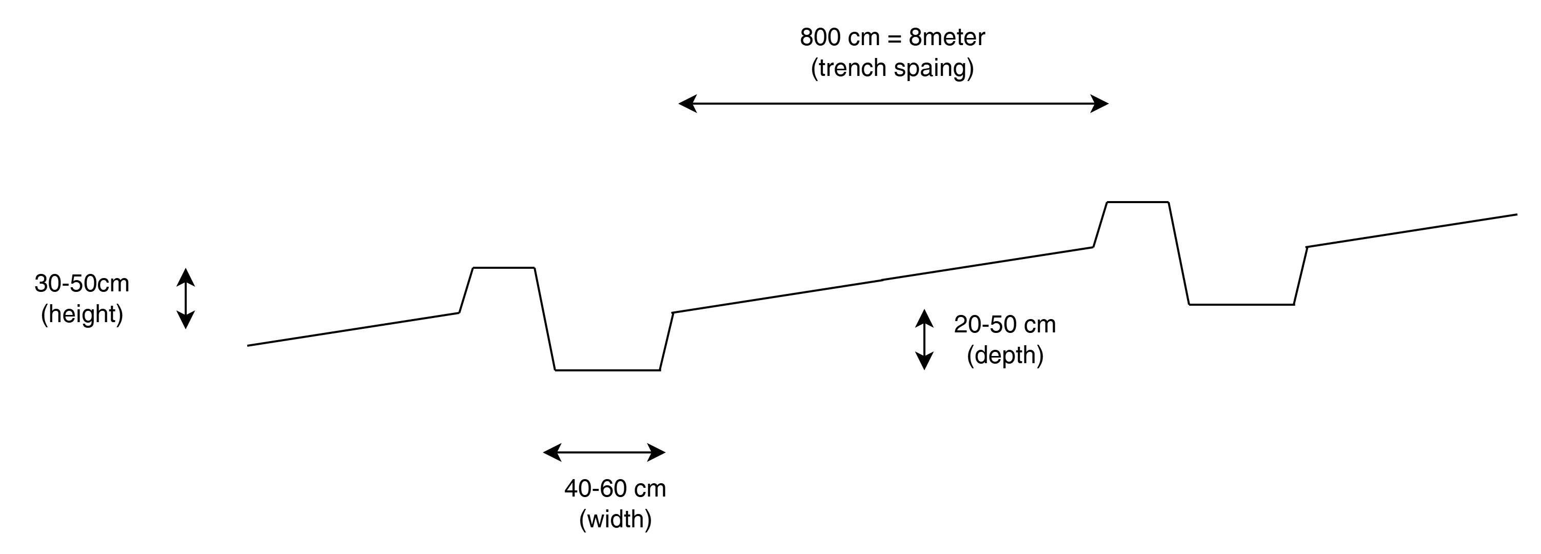
This cross-sectional profile illustrates the physical dimensions of a modified contour trench:
Width: 40–60 cm
Depth: 20–50 cm
Bund height (upslope side): 30–50 cm
Trench spacing: 8 meters
These dimensions are designed to retain and slow down surface runoff on slopes of 10–20%, enhancing water infiltration for tree or shrub growth.
ຜູ້ຂຽນ:
ICARDA
ວັນທີ:
2025
ຄຸນລັກສະນະ ຂອງເຕັກນິກ (ທີ່ກ່ຽວຂ້ອງ ກັບການແຕ້ມແຜນວາດ ທາງດ້ານເຕັກນີກ):
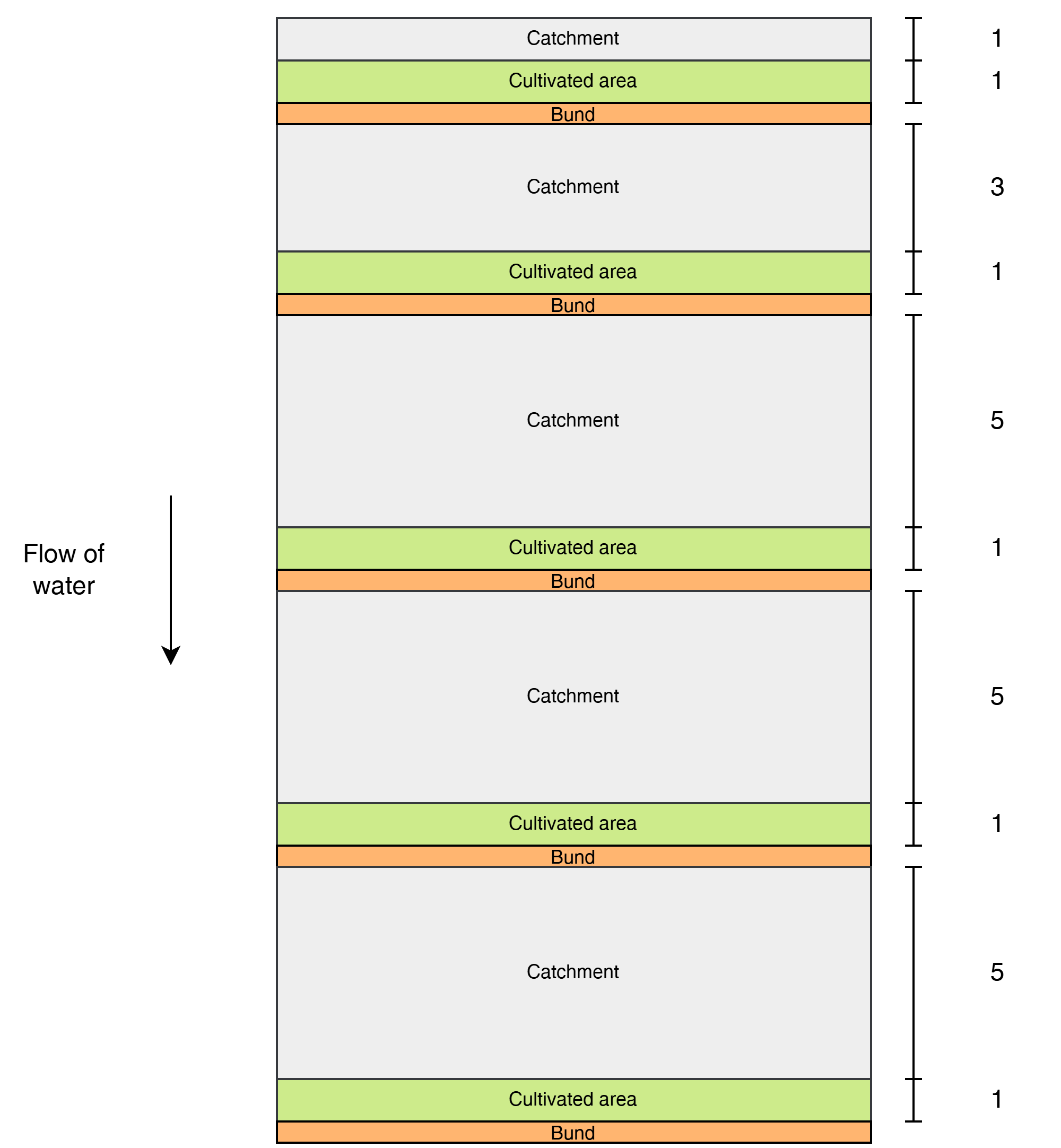
This diagram shows the layout of modified contour strips designed to enhance rainwater harvesting and crop productivity on sloped land. Each unit consists of a cultivated strip supported by a bund, located just downslope of a catchment area that concentrates surface runoff toward the crops.
Water flows downslope through the system.
The catchment-to-cultivated area ratio increases downslope to account for the growing volume and force of accumulated runoff, as well as differences in slope and infiltration capacity:
1:1 in the upper strips, where the steeper slope generates stronger runoff, and only limited water is desired to avoid erosion or damage.
3:1 in the middle strips, where moderate runoff accumulates.
5:1 in the lower strips, where the gentler slope allows more infiltration and where the lower kinetic energy of the runoff poses less risk to the structures.
ຜູ້ຂຽນ:
ICARDA
ວັນທີ:
2025
ຄຸນລັກສະນະ ຂອງເຕັກນິກ (ທີ່ກ່ຽວຂ້ອງ ກັບການແຕ້ມແຜນວາດ ທາງດ້ານເຕັກນີກ):
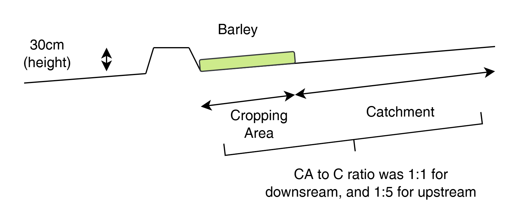
This cross-sectional view illustrates a modified contour strip:
A 30 cm high earth bund holds runoff upslope.
The cropping area (e.g., barley) is placed directly upstream (behind) the bund.
A catchment area lies upslope, sloped to direct water into the cultivated zone.
The catchment-to-cultivated ratio ranges from 5:1 (upper strips) to 1:1 (lower strips) depending on expected runoff volume, ensuring efficient water use and soil conservation.
ຜູ້ຂຽນ:
ICARDA
ວັນທີ:
2025
4.2 ຂໍ້ມູນທົ່ວໄປກ່ຽວກັບການຄິດໄລ່ປັດໃຈຂາເຂົ້າໃນການຜະລິດ ແລະ ມູນຄ່າອື່ນໆ
ລະບຸ ວິທີການ ຄຳໃຊ້ຈ່າຍ ແລະ ປັດໄຈນໍາເຂົ້າ ທີ່ໄດ້ຄິດໄລ່:
- ຕໍ່ພື້ນທີ່ ທີ່ໄດ້ຈັດຕັ້ງປະຕິບັດ ເຕັກໂນໂລຢີ
ໃຫ້ລະບຸຫົວໜ່ວຍ ຂະໜາດ ແລະ ເນື້ອທີ່:
3 ha (with half: half of each RWH technology)
ລະບຸ ສະກຸນເງິນທີ່ໃຊ້ສໍາລັບ ການຄິດໄລ່ຄ່າໃຊ້ຈ່າຍ:
- USA
ລະບຸ ຄ່າຈ້າງ ຄ່າແຮງງານສະເລ່ຍ ຕໍ່ ວັນ:
10
4.3 ການສ້າງຕັ້ງກິດຈະກໍາ
| ກິດຈະກໍາ | Timing (season) | |
|---|---|---|
| 1. | Contour marking | 22–23 September |
| 2. | Tractor ploughing | 24–25 September |
| 3. | Manual shaping/finishing | 25–26 September |
| 4. | Tree/shrub planting | 26–27 September |
4.4 ຕົ້ນທຶນ ແລະ ປັດໄຈຂາເຂົ້າທີ່ຈໍາເປັນໃນຈັດຕັ້ງປະຕິບັດ
| ລະບຸ ປັດໃຈ ນໍາເຂົ້າ ໃນການຜະລີດ | ຫົວໜ່ວຍ | ປະລິມານ | ຕົ້ນທຶນ ຕໍ່ຫົວໜ່ວຍ | ຕົ້ນທຶນທັງໝົດ ຂອງປັດໃຈຂາເຂົ້າ ໃນການຜະລິດ | % ຂອງຕົ້ນທຶນທັງໝົດ ທີ່ຜູ້ນໍາໃຊ້ທີ່ດິນ ໃຊ້ຈ່າຍເອງ | |
|---|---|---|---|---|---|---|
| ແຮງງານ | Contour trench construction | Person-days | 24.0 | |||
| ແຮງງານ | Bunds for contour strips | Person-days | 15.0 | |||
| ແຮງງານ | Marking contours | Person-days | 4.0 | |||
| ອຸປະກອນ | Ploughing (contour trenches) | Machine-days | 3.0 | |||
| ອຸປະກອນ | Ploughing (contour strips) | Machine-days | 2.0 | |||
| ວັດສະດຸໃນການປູກ | Almond seedlings | 100.0 | ||||
| ວັດສະດຸໃນການປູກ | Shrubs | 85.0 | ||||
| ຝຸ່ນ ແລະ ຢາຊີວະພາບ | Manure | kg | 600.0 | |||
| ອື່ນໆ | Lumpsum contour strips | 1.0 | 1000.0 | 1000.0 | ||
| ອື່ນໆ | Lumpsum contour trenches | 1.0 | 1000.0 | 1000.0 | ||
| ຕົ້ນທຶນທັງໝົດ ໃນການຈັດຕັ້ງປະຕິບັດ ເຕັກໂນໂລຢີ | 2000.0 | |||||
| ຄ່າໃຊ້ຈ່າຍທັງໝົດ ສຳລັບການສ້າງຕັ້ງເຕັກໂນໂລຢີ ເປັນສະກຸນເງີນໂດລາ | 2000.0 | |||||
ຖ້າທ່ານບໍ່ສາມາດ ໄຈ້ແຍກຄ່າໃຊ້ຈ່າຍໃນຕາຕະລາງຂ້າງເທິງ, ໃຫ້ຄາດຄະເນຂອງຄ່າໃຊ້ຈ່າຍທັງຫມົດ ຂອງການສ້າງເຕັກໂນໂລຢີ:
2000.0
ຄວາມຄິດເຫັນ:
Total implementation costs are around 2k USD. 50/50 between the two designs.
We have spent around 310 for tractor
300 for loader for levelling
270 labour for shaping the pits (after tractor)
400 for ploughing prior of planting the barley
340 for no till planter services for planting the barley
250 labour for applying fertilizer
100 for fertilizer (inc transport)
Estimation 20-50 for labour for plating the seedlings
4.5 ບໍາລຸງຮັກສາ / ແຜນຈັດຕັ້ງປະຕິບັດ ກິດຈະກໍາ
| ກິດຈະກໍາ | ໄລຍະເວລາ / ຄວາມຖີ່ | |
|---|---|---|
| 1. | Inspection and incidental repairs | |
| 2. | Potentially sediment cleaning |
4.6 ຄ່າໃຊ້ຈ່າຍ ແລະ ປັດໄຈນໍາເຂົ້າທີ່ຈໍາເປັນສໍາລັບການບໍາລຸງຮັກສາກິດຈະກໍາ / ແຜນປະຕິບັດ (ຕໍ່ປີ)
ຄວາມຄິດເຫັນ:
No numbers have been recorded yet as the structures are new. An estimate of the maintenance costs would be 10-25% of the establishment costs.
5. ສະພາບແວດລ້ອມທໍາມະຊາດ ແລະ ມະນຸດ
5.1 ອາກາດ
ປະລິມານນໍ້າຝົນປະຈໍາປີ
- < 250 ມີລິແມັດ
- 251-500 ມີລິແມັດ
- 501-750 ມີລິແມັດ
- 751-1,000 ມີລິແມັດ
- 1,001-1,500 ມີລິແມັດ
- 1,501-2,000 ມີລິແມັດ
- 2,001-3,000 ມີລິແມັດ
- 3,001-4,000 ມີລິແມັດ
- > 4,000 ມີລິແມັດ
ໃຫ້ລະບຸສະເລ່ຍ ປະລິມານນໍ້າຝົນຕົກປະຈໍາປີ ເປັນມິນລິແມັດ (ຖ້າຫາກຮູ້ຈັກ):
325.00
ເຂດສະພາບອາກາດກະສິກໍາ
- ເຄິ່ງແຫ້ງແລ້ງ
5.2 ພູມິປະເທດ
ຄ່າສະເລ່ຍ ຄວາມຄ້ອຍຊັນ:
- ພື້ນທີ່ຮາບພຽງ (0-2%)
- ອ່ອນ (3-5 %)
- ປານກາງ (6-10 %)
- ມ້ວນ (11-15 %)
- ເນີນ(16-30%)
- ໍຊັນ (31-60%)
- ຊັນຫຼາຍ (>60%)
ຮູບແບບຂອງດິນ:
- ພູພຽງ / ທົ່ງພຽງ
- ສັນພູ
- ເປີ້ນພູ
- ເນີນພູ
- ຕີນພູ
- ຮ່ອມພູ
ເຂດລະດັບສູງ:
- 0-100 ແມັດ a.s.l.
- 101-500 ແມັດ a.s.l.
- 501-1,000 ແມັດ a.s.l.
- 1,001-1,500 ແມັດ a.s.l.
- 1,501-2,000 ແມັດ a.s.l.
- 2,001-2,500 ແມັດ a.s.l.
- 2,501-3,000 ແມັດ a.s.l.
- 3,001-4,000 ແມັດ a.s.l.
- > 4,000 ແມັດ a.s.l.
ໃຫ້ລະບຸ ເຕັກໂນໂລຢີ ທີ່ໄດ້ຖືກນຳໃຊ້:
- ບໍ່ກ່ຽວຂ້ອງ
ຄຳເຫັນ ແລະ ຂໍ້ມູນສະເພາະ ເພີ່ມເຕີມ ກ່ຽວກັບ ພູມີປະເທດ:
The strips are better suited for the flatter areas and the trenches on the higher sloping areas.
5.3 ດິນ
ຄວາມເລິກ ຂອງດິນສະເລ່ຍ:
- ຕື້ນຫຼາຍ (0-20 ຊັງຕີແມັດ)
- ຕື້ນ (21-50 ຊຕມ)
- ເລີກປານກາງ (51-80 ຊຕມ)
- ເລິກ (81-120 ຊມ)
- ເລິກຫຼາຍ (> 120 cm)
ເນື້ອດິນ (ໜ້າດິນ):
- ປານກາງ (ດິນໜຽວ, ດິນໂຄນ)
ເນື້ອດິນ (ເລິກຈາກໜ້າດິນ ລົງໄປຫຼາຍກວ່າ 20 ຊັງຕິແມັດ):
- ປານກາງ (ດິນໜຽວ, ດິນໂຄນ)
ຊັ້ນອິນຊີວັດຖຸ ເທິງໜ້າດິນ:
- ປານກາງ (1-3 %)
5.4 ມີນໍ້າ ແລະ ຄຸນນະພາບ
ລະດັບ ນໍ້າໃຕ້ດິນ:
5-50 ແມັດ
ການມີນໍ້າ ເທິງໜ້າດິນ:
ທຸກຍາກ / ບໍ່ມີ
ຄຸນນະພາບນໍ້າ (ບໍ່ມີການບໍາບັດ):
ນຳໃຊ້ເຂົ້າໃນການຜະລິດກະສິກໍາພຽງຢ່າງດຽງ (ຊົນລະປະທານ)
ຄຸນນະພາບນ້ຳ ໝາຍເຖີງ:
ທັງນ້ຳໃຕ້ດິນ ແລະ ນ້ຳໜ້າດິນ
ມີບັນຫາ ກ່ຽວກັບນໍ້າເຄັມບໍ່?
ບໍ່ແມ່ນ
ເກີດມີນໍ້າຖ້ວມ ໃນພື້ນທີ່ບໍ່?
ແມ່ນ
ເປັນປົກກະຕິ:
ຕອນ
5.5 ຊີວະນາໆພັນ
ຄວາມຫຼາກຫຼາຍ ທາງສາຍພັນ:
- ຕໍ່າ
ຄວາມຫຼາກຫຼາຍ ທາງດ້ານ ທີ່ຢູ່ອາໃສ ຂອງສິ່ງທີ່ມີຊີວິດ:
- ຕໍ່າ
5.6 ຄຸນລັກສະນະ ຂອງຜູ້ນໍາໃຊ້ທີ່ດິນ ທີ່ໄດ້ນໍາໃຊ້ເຕັກໂນໂລຢີ
ຢູ່ປະຈຳ ຫຼື ເຄື່ອນຍ້າຍຕະຫຼອດ:
- ບໍ່ເຄື່ອນໄຫວ
ລະບົບ ການຕະຫຼາດ ແລະ ຜົນຜະລິດ:
- ປະສົມປົນເປ( ກຸ້ມຕົນເອງ/ເປັນສິນຄ້າ)
ລາຍຮັບ ທີ່ບໍ່ໄດ້ມາຈາກ ການຜະລິດ ກະສິກໍາ:
- 10-50 % ຂອງລາຍຮັບທັງໝົດ
ລະດັບຄວາມຮັ່ງມີ:
- ທຸກຍາກຫຼາຍ
- ທຸກຍາກ
ບຸກຄົນ ຫຼື ກຸ່ມ:
- ບຸກຄົນ / ຄົວເຮືອນ
- ການຈ້າງງານ (ບໍລິສັດ, ອົງການ ລັດຖະບານ)
ລະດັບ ການຫັນເປັນກົນຈັກ:
- ການໃຊ້ແຮງງານຄົນ
- ເຄື່ອງກົນຈັກ
ເພດ:
- ຜູ້ຊາຍ
ອາຍຸ ຂອງຜູ້ນໍາໃຊ້ທີ່ດິນ:
- ເດັກນ້ອຍ
- ໄວກາງຄົນ
5.7 ເນື້ອທີ່ສະເລ່ຍຂອງດິນ ທີ່ຜູ້ນຳໃຊ້ທີ່ດິນ ໃຊ້ເຮັດເຕັກໂນໂລຢີ
- <0.5 ເຮັກຕາ
- 0.5-1 ເຮັກຕາ
- 1-2 ເຮັກຕາ
- 2-5 ເຮັກຕາ
- 5-15 ເຮັກຕາ
- 15-50 ເຮັກຕາ
- 50-100 ເຮັກຕາ
- 100-500 ເຮັກຕາ
- 500-1,000 ເຮັກຕາ
- 1,000-10,000 ເຮັກຕາ
- > 10,000 ເຮັກຕາ
ຖືໄດ້ວ່າ ເປັນຂະໜາດນ້ອຍ, ກາງ ຫຼື ໃຫຍ່ (ອີງຕາມເງື່ອນໄຂ ສະພາບຄວາມເປັນຈິງ ຂອງທ້ອງຖີ່ນ)? :
- ຂະໜາດນ້ອຍ
5.8 ເຈົ້າຂອງທີ່ດິນ, ສິດໃຊ້ທີ່ດິນ, ແລະ ສິດທິການນໍາໃຊ້ນໍ້າ
ເຈົ້າຂອງດິນ:
- ລັດ
- ບຸກຄົນ, ທີ່ມີຕໍາແໜ່ງ
ສິດທິ ໃນການນໍາໃຊ້ທີ່ດິນ:
- ບຸກຄົນ
- Water not available
ສິດນຳໃຊ້ທີ່ດິນ ແມ່ນ ອີງໃສ່ລະບົບກົດໝາຍແບບດັ້ງເດີມບໍ?
ແມ່ນ
5.9 ການເຂົ້າເຖິງການບໍລິການ ແລະ ພື້ນຖານໂຄງລ່າງ
ສຸຂະພາບ:
- ທຸກຍາກ
- ປານກາງ
- ດີ
ການສຶກສາ:
- ທຸກຍາກ
- ປານກາງ
- ດີ
ການຊ່ວຍເຫຼືອ ດ້ານວິຊາການ:
- ທຸກຍາກ
- ປານກາງ
- ດີ
ການຈ້າງງານ (ຕົວຢ່າງ, ການເຮັດກິດຈະກໍາອື່ນ ທີ່ບໍ່ແມ່ນ ການຜະລິດກະສິກໍາ):
- ທຸກຍາກ
- ປານກາງ
- ດີ
ຕະຫຼາດ:
- ທຸກຍາກ
- ປານກາງ
- ດີ
ພະລັງງານ:
- ທຸກຍາກ
- ປານກາງ
- ດີ
ຖະໜົນຫົນທາງ ແລະ ການຂົນສົ່ງ:
- ທຸກຍາກ
- ປານກາງ
- ດີ
ການດື່ມນໍ້າ ແລະ ສຸຂາພິບານ:
- ທຸກຍາກ
- ປານກາງ
- ດີ
ການບໍລິການ ທາງດ້ານການເງິນ:
- ທຸກຍາກ
- ປານກາງ
- ດີ
6. ຜົນກະທົບ ແລະ ລາຍງານສະຫຼຸບ
6.1 ການສະແດງຜົນກະທົບ ພາຍໃນພື້ນທີ່ ທີ່ໄດ້ຈັດຕັ້ງປະຕິບັດ ເຕັກໂນໂລຢີ
ຜົນກະທົບທາງເສດຖະກິດສັງຄົມ
ການຜະລິດ
ການຜະລິດພືດ
ຄວາມຄິດເຫັນ / ລະບຸແຈ້ງ:
At first relatively unproductive land, with rwh techniques, production is increase is expected
ຄວາມສ່ຽງ ຕໍ່ຜົນຜະລິດ
ຄວາມຄິດເຫັນ / ລະບຸແຈ້ງ:
More water is retained in the land and in the soil hence less drought vulnerable
ຄວາມໜາແໜ້ນ ຂອງຜົນຜະລິດ
ຄວາມຄິດເຫັນ / ລະບຸແຈ້ງ:
Trees, shrubs, and crops
ການຈັດການຄຸ້ມຄອງທີ່ດິນ
ຄວາມຄິດເຫັນ / ລະບຸແຈ້ງ:
Structures require some maintenance
ລາຍໄດ້ ແລະ ຄ່າໃຊ້ຈ່າຍ
ລາຍຮັບ ຈາກການຜະລີດ
ຄວາມຄິດເຫັນ / ລະບຸແຈ້ງ:
Increase in more stable yield is positive for farm income
ຜົນກະທົບດ້ານວັດທະນາທໍາສັງຄົມ
ການຄໍ້າປະກັນ ສະບຽງອາຫານ / ກຸ້ມຢູ່ກຸ້ມກິນ
ຄວາມຄິດເຫັນ / ລະບຸແຈ້ງ:
Less dependent on external food during dry periods
ຄວາມຮູ້ກ່ຽວກັບ ການຄຸ້ມຄອງ ທີ່ດິນແບບຍືນຍົງ / ການເຊື່ອມໂຊມຂອງດິນ
ຄວາມຄິດເຫັນ / ລະບຸແຈ້ງ:
Implementation was together with local land users, enhancing their knowledge in SLM
ຜົນກະທົບຕໍ່ລະບົບນິເວດ
ວົງຈອນນໍ້າ / ນໍ້າ
ການຂຸດຄົ້ນ / ການເກັບກັກນໍ້າ
ຄວາມຄິດເຫັນ / ລະບຸແຈ້ງ:
Water is much better retained as consequence of the rwh structures.
ການໄຫຼ ຂອງນໍ້າໜ້າດິນ
ຄວາມຄິດເຫັນ / ລະບຸແຈ້ງ:
Run-off (damage) poses less because the ability to accumale is limited because water is now trapped by trenches and bunds
ດິນ
ຄວາມຊຸ່ມຂອງດິນ
ການປົກຄຸມຂອງດິນ
ການສູນເສຍດິນ
ການທັບຖົມຂອງດິນ
ຊີວະນານາພັນ: ສັດ, ພືດ
ການປົກຫຸ້ມຂອງພືດ
ມວນຊີວະພາບ / ຢູ່ເທິງຊັ້ນດິນ C
ລະບຸ ການປະເມີນຜົນກະທົບ ຕໍ່ສະຖານທີ່ (ການວັດແທກ):
Expert estimates
6.2 ຜົນກະທົບທາງອ້ອມ ຈາກການນໍາໃຊ້ເຕັກໂນໂລຢີ
ນໍ້າຖ້ວມຢູ່ເຂດລຸ່ມນໍ້າ
ຄວາມຄິດເຫັນ / ລະບຸແຈ້ງ:
More water is retained in the catchment, hence less flood risk downstream
ການທັບຖົມ ຂອງດິນຕະກອນ ຢູ່ເຂດລຸ່ມນໍ້າ
ຄວາມຄິດເຫັນ / ລະບຸແຈ້ງ:
The RWH structures can trap sediments
ລົມ ທີ່ພັດເອົາຕະກອນ
ຄວາມຄິດເຫັນ / ລະບຸແຈ້ງ:
Because of improved vegetation cover, soil is better held together, becoming less susceptible for being lifted up the wind
ພື້ນທີ່ທໍາການຜະລິດ ຂອງເພື່ອນບ້ານທີ່ຢູ່ໃກ້ຄຽງ ໄດ້ຮັບຜົນກະທົບ
ຄວາມເສຍຫາຍ ກ່ຽວກັບພື້ນຖານໂຄງລ່າງ ສາທາລະນະ / ເອກກະຊົນ
ກໍານົດ ການປະເມີນ ຜົນກະທົບທາງນອກ (ການວັດແທກ):
Expert estimates
6.3 ການປ້ອງກັນ ແລະ ຄວາມບອບບາງ ຂອງເຕັກໂນໂລຢິ ໃນການປ່ຽນແປງສະພາບດິນຟ້າອາກາດ ແລະ ກ່ຽວຂ້ອງກັບອາກາດທີ່ມີການປ່ຽນແປງທີ່ຮຸນແຮງ / ໄພພິບັດທາງທໍາມະຊາດ (ຮັບຮູ້ໄດ້ໂດຍຜູ້ນໍາໃຊ້ທີ່ດິນ)
ການປ່ຽນແປງດິນຟ້າອາກາດ ເທື່ອລະກ້າວ
ການປ່ຽນແປງດິນຟ້າອາກາດ ເທື່ອລະກ້າວ
| ລະດູການ | ເພີ່ມຂື້ນ ຫຼື ຫຼຸດລົງ | ການນໍາໃຊ້ ເຕັກໂນໂລຢີ ສາມາດ ຮັບມື ໄດ້ຄືແນວໃດ? | |
|---|---|---|---|
| ປະລິມານນໍ້າຝົນປະຈໍາປີ | ຫຼຸດລົງ | ປານກາງ |
ອາກາດ ທີ່ກ່ຽວພັນກັບຄວາມຮຸນແຮງ (ໄພພິບັດທາງທໍາມະຊາດ)
ໄພພິບັດທາງອຸທົກກະສາກ
| ການນໍາໃຊ້ ເຕັກໂນໂລຢີ ສາມາດ ຮັບມື ໄດ້ຄືແນວໃດ? | |
|---|---|
| ນໍ້າຖ້ວມຮູນແຮງ | ດີ |
6.4 ການວິເຄາະຕົ້ນທຶນ ແລະ ຜົນປະໂຫຍດ
ຈະເຮັດປະໂຫຍດເພື່ອປຽບທຽບກັບຄ່າໃຊ້ຈ່າຍກັບສິ່ງກໍ່ສ້າງ (ຈາກທັດສະນະຂອງຜູ້ນຳໃຊ້ທີ່ດິນ) ໄດ້ແນວໃດ?
ຜົນຕອບແທນ ໃນໄລຍະສັ້ນ:
ຜົນກະທົບທາງລົບເລັກນ້ອຍ
ຜົນຕອບແທນ ໃນໄລຍະຍາວ:
ຜົນກະທົບທາງບວກຫຼາຍ
ຈະໄດ້ຮັບຜົນປະໂຫຍດເມື່ອປຽບທຽບກັບ / ຄ່າໃຊ້ຈ່າຍໃນການບຳລຸງຮັກສາທີເ່ກີດຂື້ນອິກ (ຈາກທັດສະນະຄະຕິຂອງຜູ້ນຳໃຊ້ທີ່ດິນ) ໄດ້ແນວໃດ?
ຜົນຕອບແທນ ໃນໄລຍະສັ້ນ:
ຜົນກະທົບທາງບວກ
ຜົນຕອບແທນ ໃນໄລຍະຍາວ:
ຜົນກະທົບທາງບວກຫຼາຍ
ຄວາມຄິດເຫັນ:
Expectations
6.5 ການປັບຕົວຮັບເອົາເຕັກໂນໂລຢີ
- ກໍລະນີດຽວ / ການທົດລອງ
ທັງໝົດນັ້ນ ແມ່ນໃຜ ໄດ້ປັບຕົວເຂົ້າ ໃນການນໍາໃຊ້ ເຕັກໂນໂລຢີ, ມີຈັກຄົນ ທີ່ສາມາດເຮັດເອງໄດ້, ຕົວຢ່າງ, ປາດສະຈາກ ການຊ່ວຍເຫຼືອ ທາງດ້ານອຸປະກອນ / ການຈ່າຍເປັນເງິນ?
- 0-10%
6.6 ການປັບຕົວ
ໄດ້ມີການດັດປັບ ເຕັກໂນໂລຢີ ເພື່ອໃຫ້ແທດເໝາະກັບເງື່ອນໄຂ ການປ່ຽນແປງບໍ?
ບໍ່ແມ່ນ
6.7 ຈຸດແຂງ / ຂໍ້ດີ / ໂອກາດ ໃນການນໍາໃຊ້ ເຕັກໂນໂລຢີ
| ຈຸດແຂງ / ຂໍ້ດີ / ໂອກາດໃນການນໍາໃຊ້ທີ່ດິນ |
|---|
| Income diversification through forest nut and fodder production: Modified contour trenches enable the planting of both almond trees and fodder shrubs, supporting a mix of high-value cash crops and livestock-based livelihoods while restoring degraded sloped land. |
| Higher and more stable yields in flat rainfed systems: Modified contour strips improve water use efficiency and infiltration in cereal fields (e.g., barley), leading to better germination, stronger crop stands, and increased yields—especially valuable in low-rainfall zones where productivity is otherwise constrained. |
| ຈຸດແຂງ / ຈຸດດີ / ໂອກາດ ຈາກທັດສະນະຂອງຜູ້ປ້ອນຂໍ້ມູນ ຫຼື ບຸກຄົນສຳຄັນ |
|---|
| Improved erosion control and landscape stability: Both techniques reduce surface runoff, limit gully formation, and prevent soil loss—thereby rehabilitating degraded land and protecting long-term soil productivity. |
| Enhanced soil moisture and drought resilience: By capturing and infiltrating rainwater along the contour, both methods improve water availability in the root zone, boosting the performance of crops and vegetation under arid and increasingly variable climate conditions. |
| Cost-effective and locally scalable: Constructed with accessible tools like mouldboard ploughs and finished by manual labour, both structures are affordable, require minimal inputs, and are suitable for community-based, participatory land restoration efforts. |
6.8 ຈຸດອ່ອນ / ຂໍ້ເສຍ / ຄວາມສ່ຽງ ໃນການນໍາໃຊ້ ເຕັກໂນໂລຢີ ແລະ ວິທີການແກ້ໄຂບັນຫາ
| ຈຸດອ່ອນ / ຂໍ້ເສຍ / ຄວາມສ່ຽງໃນມຸມມອງຂອງຜູ້ນໍາໃຊ້ທີ່ດິນ | ມີວິທີການແກ້ໄຂຄືແນວໃດ? |
|---|---|
| One challenge with modified contour trenches is that their effectiveness can be reduced over time due to sediment accumulation inside the trenches, which may reduce their water storage capacity and redirect runoff flow, especially during intense rainfall events. In addition, the bunds can weaken or collapse if the soil is loosely compacted or livestock walk over them. | Periodic maintenance is required every 4–5 years to remove sediment, re-shape trenches, and recompact or reinforce bunds, especially in sensitive segments. Involving local land users in routine inspection and light seasonal upkeep helps sustain long-term functionality. Introducing controlled grazing or fencing can prevent trampling by animals. |
| Modified contour strips are relatively low structures and therefore vulnerable to damage or overtopping if catchment-to-cultivated ratios are misjudged, or if bunds are not compacted well—especially during unexpected intense rainfall. Another limitation is that the strips rely on proper elevation spacing and contour accuracy, which requires some technical skill. | Ensuring accurate layout using a laser level and proper training of local staff during implementation is key. Adjusting catchment ratios downslope (e.g., from 5:1 to 1:1) helps avoid overloading. Annual visual checks and minor repairs after each rainy season are usually sufficient to maintain bund height and integrity. |
7. ເອກະສານອ້າງອີງ ແລະ ການເຊື່ອມຕໍ່
7.1 ວິທີການ / ແຫຼ່ງຂໍ້ມູນ
- ການໄປຢ້ຽມຢາມພາກສະໜາມ, ການສໍາຫຼວດພາກສະໜາມ
- ການສໍາພາດ ຜູ້ນໍາໃຊ້ທີ່ດິນ
- ສໍາພາດ ຊ່ຽວຊານ ການຄຸ້ມຄອງ ດິນແບບຍືນຍົງ
- ການລວບລວມ ບົດລາຍງານ ແລະ ເອກະສານ ອື່ນໆ ທີ່ມີຢູ່ແລ້ວ
7.3 ເຊື່ອມຕໍ່ກັບຂໍ້ມູນທີ່ກ່ຽວຂ້ອງໂດຍກົງ
ຫົວຂໍ້ / ພັນລະນາ:
Oweis, T. and Haddad, M. 2023. Rainwater Harvesting Design Manual: Micro-catchment Systems for Drylands Agriculture. Lebanon, Beirut: International Center for Agricultural Research in the Dry Areas (ICARDA).
URL:
https://hdl.handle.net/10568/169777
ຫົວຂໍ້ / ພັນລະນາ:
Mekdaschi Studer, R. & Liniger H. (2013). Water Harvesting: Guidelines to Good Practice. WOCAT, Bern, Switzerland
URL:
wocat.net/documents/85/WaterHarvesting_lowresolution.pdf
ຫົວຂໍ້ / ພັນລະນາ:
Critchley, W. & Siegert, K., (1991). Water Harvesting: A Manual for the Design and Construction of Water Harvesting Schemes for Plant Production. Rome: Food and Agriculture Organisation, Rome
URL:
https://www.fao.org/3/U3160E/U3160E00.htm
ຂໍ້ມູນການເຊື່ອມຕໍ່ ແລະ ເນື້ອໃນ
ຂະຫຍາຍທັງໝົດ ຍຸບທັງໝົດການເຊື່ອມຕໍ່
ບໍ່ມີຂໍ້ມູນການເຊື່ອມຕໍ່
ເນື້ອໃນ
ບໍ່ມີເນື້ອໃນ