Riparian buffer strips [ສະໂນວາເນຍ]
- ການສ້າງ:
- ປັບປູງ:
- ຜູ້ສັງລວມຂໍ້ມູນ: Gregor Kramberger
- ບັນນາທິການ: Tamara Korošec
- ຜູ້ທົບທວນຄືນ: William Critchley, Rima Mekdaschi Studer
Varovalni pasovi ob vodotokih
technologies_6246 - ສະໂນວາເນຍ
ເບິ່ງພາກສ່ວນ
ຂະຫຍາຍທັງໝົດ ຍຸບທັງໝົດ1. ຂໍ້ມູນທົ່ວໄປ
1.2 ຂໍ້ມູນ ການຕິດຕໍ່ພົວພັນ ຂອງບຸກຄົນທີ່ສໍາຄັນ ແລະ ສະຖາບັນ ທີ່ມີສ່ວນຮ່ວມ ໃນການປະເມີນເອກກະສານ ເຕັກໂນໂລຢີ
ຜຸ້ຊ່ຽວຊານ ດ້ານການຄຸ້ມຄອງ ທີ່ດິນແບບຍືນຍົງ:
ຜຸ້ຊ່ຽວຊານ ດ້ານການຄຸ້ມຄອງ ທີ່ດິນແບບຍືນຍົງ:
Horvat Timotej
Chamber of Agriculture and Forestry of Slovenia (KGZS) – Institute of Agriculture and Forestry Maribor Slovenia
ສະໂນວາເນຍ
co-compiler:
Ropič Andrej
Farmer
ສະໂນວາເນຍ
ຜຸ້ຊ່ຽວຊານ ດ້ານການຄຸ້ມຄອງ ທີ່ດິນແບບຍືນຍົງ:
Kep Tina
Chamber of Agriculture and Forestry of Slovenia (KGZS) – Institute of Agriculture and Forestry Maribor Slovenia
ສະໂນວາເນຍ
ຊື່ໂຄງການ ທີ່ອໍານວຍຄວາມສະດວກ ໃນການສ້າງເອກກະສານ/ປະເມີນ ເຕັກໂນໂລຢີ (ຖ້າກ່ຽວຂ້ອງ)
OPtimal strategies to retAIN and re-use water and nutrients in small agricultural catchments across different soil-climatic regions in Europe (OPTAIN)ຊື່ສະຖາບັນ (ຫຼາຍສະຖາບັນ) ທີ່ອໍານວຍຄວາມສະດວກ ໃນການສ້າງເອກກະສານ / ປະເມີນ ເຕັກໂນໂລຢີ (ຖ້າກ່ຽວຂ້ອງ)
Chamber of Agriculture and Forestry of Slovenia – Institute of Agriculture and Forestry Maribor (KGZS) - ສະໂນວາເນຍ1.3 ເງື່ອນໄຂ ກ່ຽວກັບ ການນໍາໃຊ້ຂໍ້ມູນເອກະສານ ທີ່ສ້າງຂື້ນ ໂດຍຜ່ານ ອົງການພາບລວມຂອງໂລກ ທາງດ້ານແນວທາງ ແລະ ເຕັກໂນໂລຢີ ຂອງການອານຸລັກ ທໍາມະຊາດ (WOCAT)
ຜູ້ປ້ອນຂໍ້ມູນ ແລະ ບຸກຄົນສຳຄັນ ທີ່ໃຫ້ຂໍ້ມູນ (ຫຼາຍ) ຍິນຍອມ ຕາມເງື່ອນໄຂ ໃນການນຳໃຊ້ຂໍ້ມູນ ເພື່ອສ້າງເປັນເອກກະສານຂອງ WOCAT:
ແມ່ນ
1.4 ແຈ້ງການວ່າ ດ້ວຍຄວາມຍືນຍົງຂອງ ເຕັກໂນໂລຢີ
ການນໍາໃຊ້ ເຕັກໂນໂລຢີ ດັ່ງກ່າວໄດ້ອະທິບາຍ ເຖິງບັນຫາ ກ່ຽວກັບ ການເຊື່ອມໂຊມຂອງດິນບໍ? ຖ້າບໍ່ດັ່ງນັ້ນ ມັນບໍ່ສາມາດ ຢັ້ງຢືນໄດ້ວ່າ ເປັນເຕັກໂນໂລຊີ ໃນການຄຸ້ມຄອງ ທີ່ດິນແບບຍືນຍົງ? :
ບໍ່ແມ່ນ
2. ການອະທິບາຍ ເຕັກໂນໂລຢີ ຂອງການຄຸ້ມຄອງ ທີ່ດິນແບບຍືນຍົງ
2.1 ຄໍາອະທິບາຍສັ້ນຂອງ ເຕັກໂນໂລຢີ
ການກຳໜົດຄວາມໝາຍ ຂອງເຕັກໂນໂລຢີ:
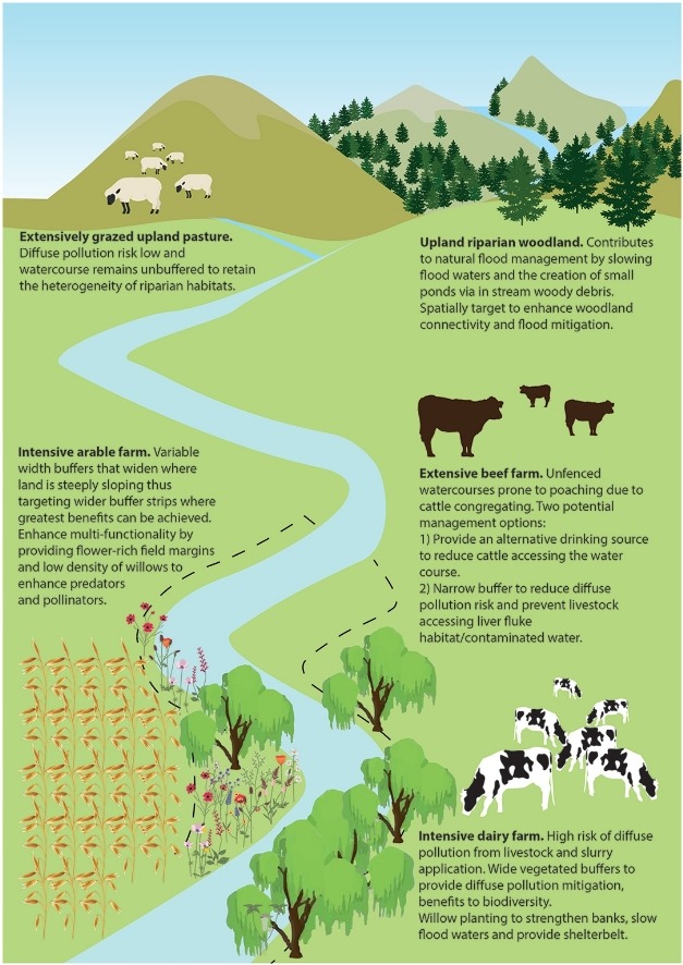
Riparian buffer strips are vegetative zones alongside watercourses. In compliance with EU and Slovenia’s Acts, these protective strips reduce soil erosion, filter pollutants, improve water quality, enhance biodiversity and support climate resilience.
2.2 ການອະທິບາຍ ລາຍລະອຽດ ຂອງເຕັກໂນໂລຢີ
ການພັນລະນາ:
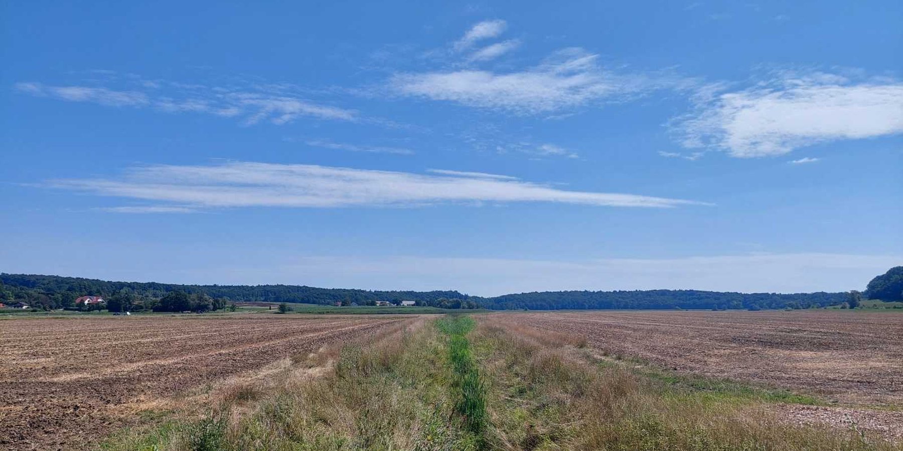
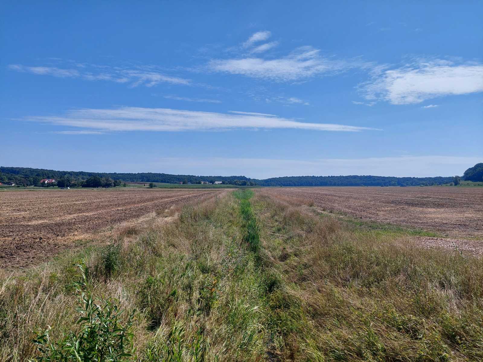
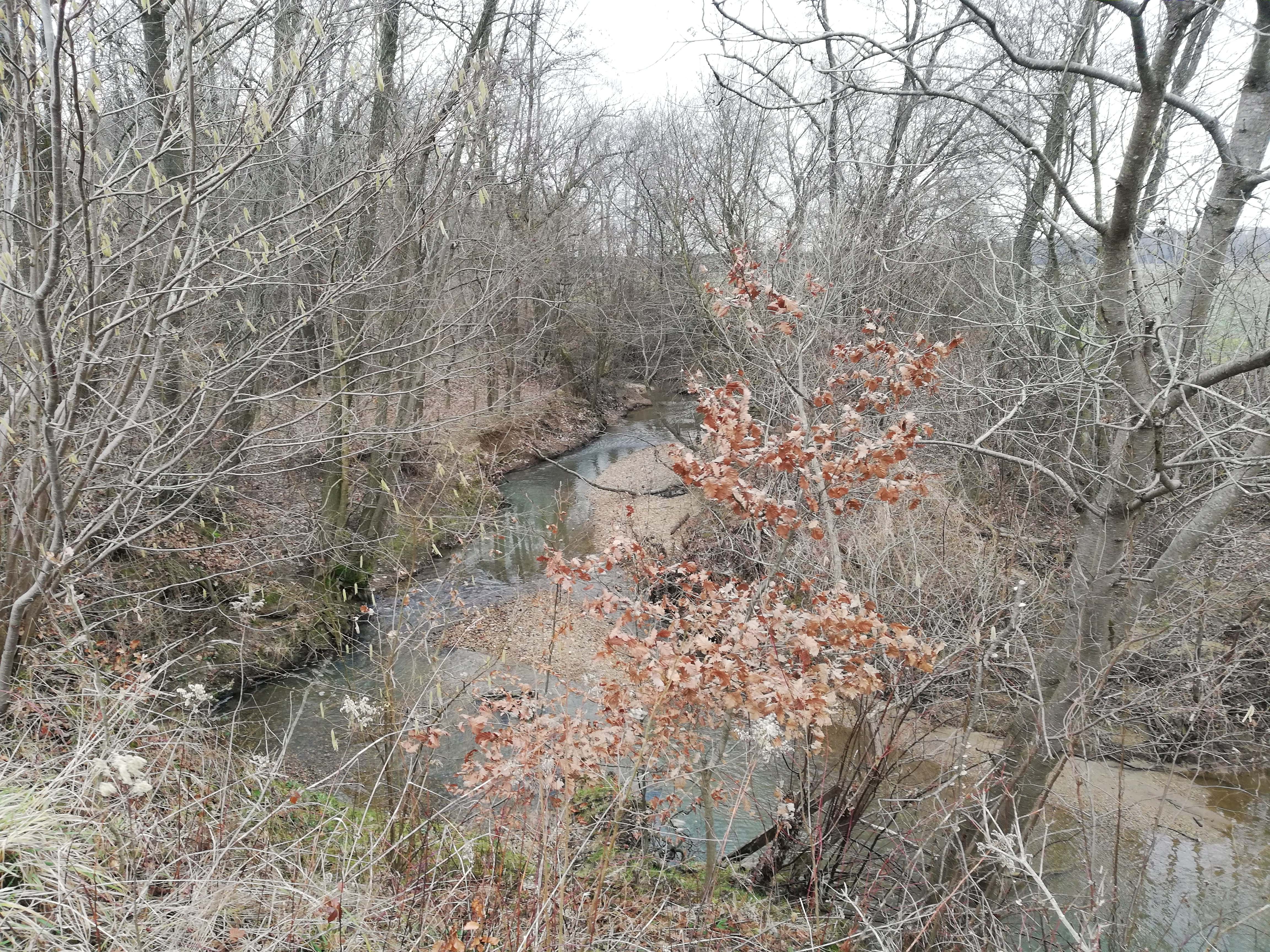
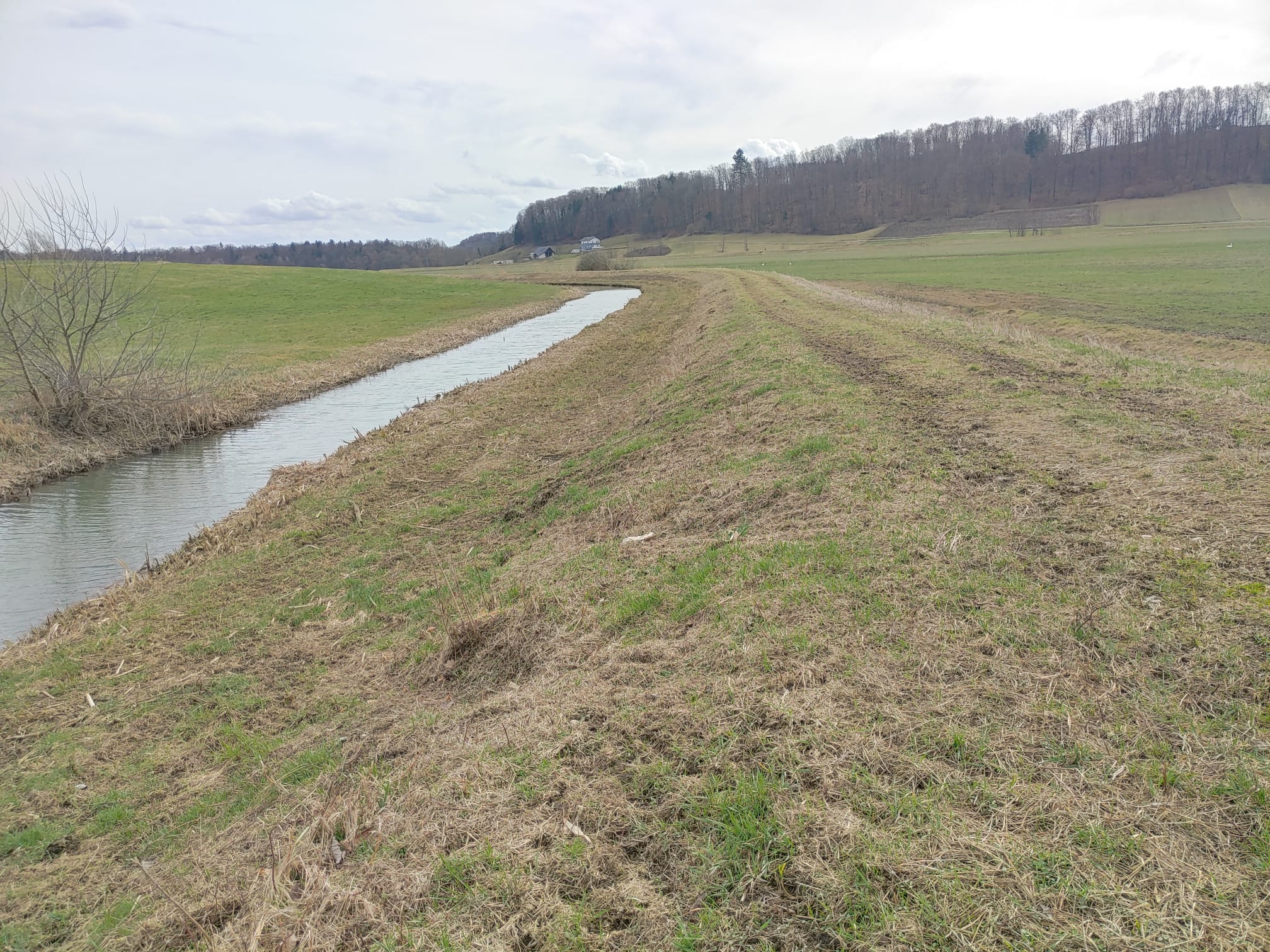
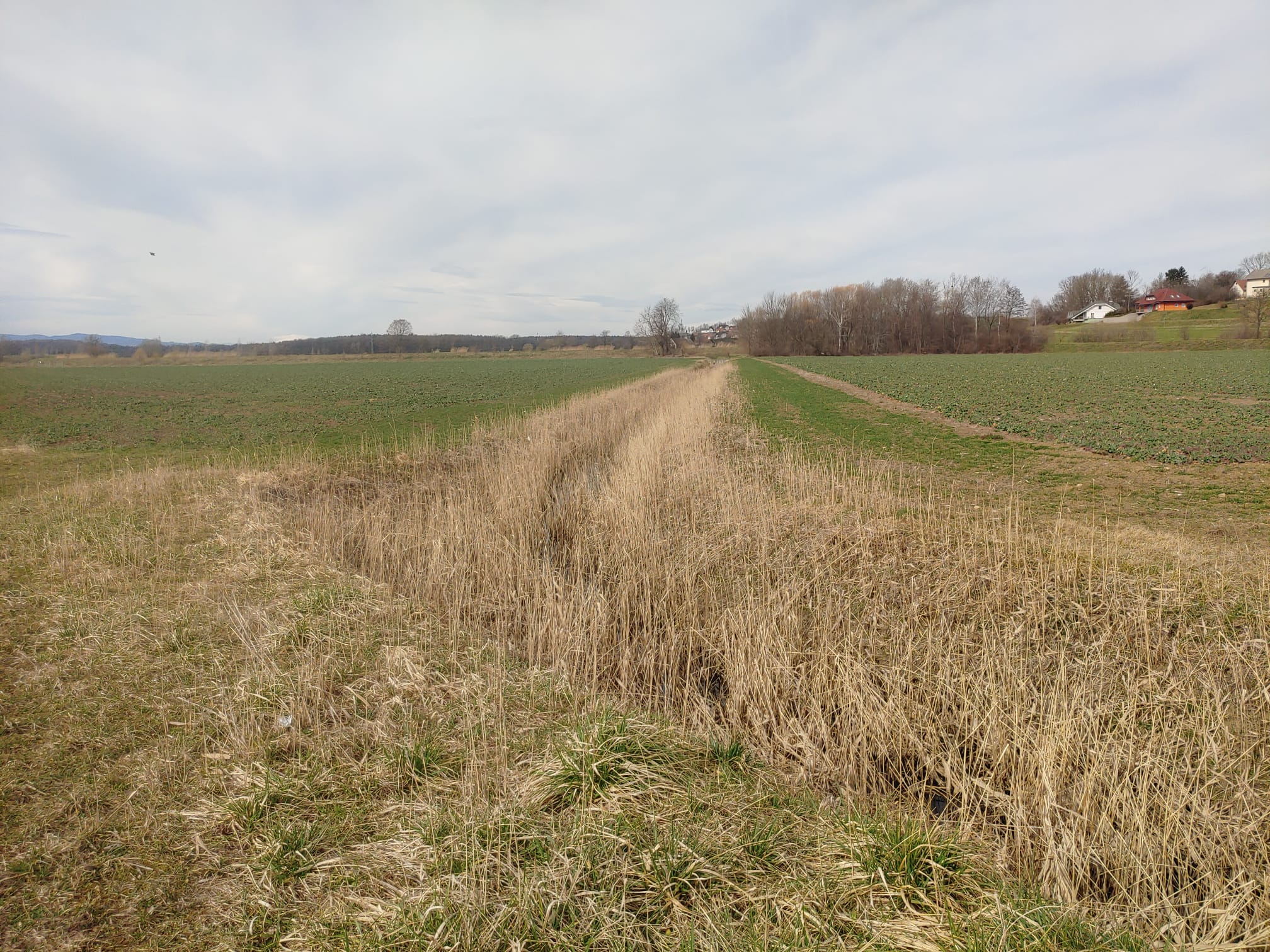
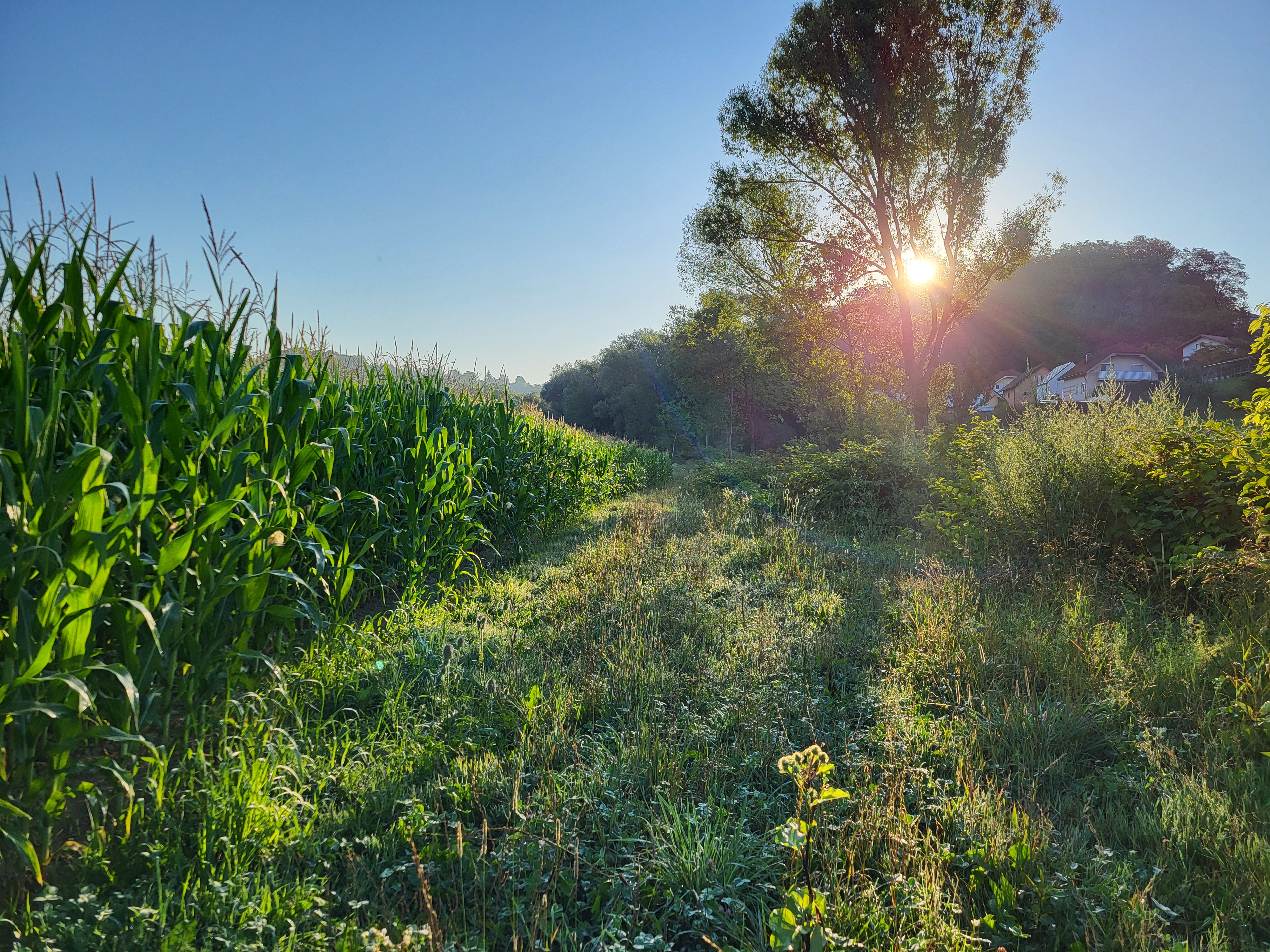
Riparian buffer strips are applied alongside all watercourses and drainage ditches in Slovenia. These buffer zones are legally mandated under the Water Act and GAEC 4 conditionality standards within the EU CAP 2023-2027 framework. Strips, of 3-15 m wide depending on size of the watercourse, serve as transition zones between cultivated fields and waterways, mitigating the impact of agriculture on aquatic ecosystems and surrounding environments.
Strips must comprise grasses, clover, alfalfa, native shrubs, and/or trees. The use of mineral and organic fertilizers is banned, as are pesticides and herbicides. Deep ploughing is prohibited, but surface tillage is allowed for maintenance and sowing (especially if the buffer strip is classified as agricultural land). Grazing is permitted, but with specific restrictions. If the farmer does not maintain the buffer strip, the area is excluded from the system of agricultural land in use and becomes ineligible for any subsidies.
The main purpose of riparian buffer strips is to protect and improve water quality, prevent soil erosion, and support biodiversity. By intercepting surface runoff, they reduce nitrogen, phosphorus, and pesticide contamination from agricultural land. The dense vegetation stabilizes riverbanks. The strips also enhance habitat connectivity for wildlife, providing nesting sites and food sources. Additionally, they play a role in flood mitigation by reducing the speed of stormwater runoff and thus improving water infiltration and retention.
To establish and maintain riparian buffer strips, an initial assessment of existing vegetation and soil determines whether additional planting is needed. If the area lacks sufficient vegetation, direct seeding with suitable species is carried out. Maintenance usually involves mowing, mulching, and occasional pruning. Pruning refers to the removal of overgrown trees and shrubs along the riverbank to prevent spreading onto agricultural land. This work typically requires tools such as a chainsaw and a tractor with a trailer for removing the cut woody material. Farmers must also comply with monitoring and reporting requirements under CAP regulations.
The benefits of riparian buffer strips are primarily environmental. By filtering pollutants before they enter watercourses, they contribute to cleaner water, reduced eutrophication, and improved aquatic ecosystems. They help maintain land productivity in the long term, reducing the need for costly interventions such as dredging or erosion control measures. The vegetation within the strips absorbs carbon, contributing to climate mitigation efforts. Additionally, by complying with regulations, farmers gain access to CAP subsidies and other environmental incentives, making implementation more financially viable.
Despite these advantages, land users have mixed opinions about such strips. Some farmers appreciate the additional forage production, and others find that the buffer zones serve as useful access paths around their fields, making machinery operation easier. However, many landowners dislike the loss of productive farmland, particularly those near first-order watercourses, where wider buffer strips are required. The loss of cultivated land can result in lower crop yields and income reductions, with farms experiencing up to a 6.2% decrease in arable land and financial losses estimated at 7,448 € per farm annually (Lešnik et al. 2024). Some farmers express concerns about the complexity of legal requirements and the costs associated with compliance and maintenance.
While riparian buffer strips are essential for environmental sustainability, their impact on farm economics must be carefully considered. Future strategies may involve flexible width requirements or integration with agroforestry systems to maximize their benefits while minimizing financial burdens.
2.3 ຮູບພາບຂອງເຕັກໂນໂລຢີ
ສື່ຮູບພາບ
2.5 ປະເທດ / ເຂດ / ສະຖານທີ່ບ່ອນທີ່ ເຕັກໂນໂລຢີ ໄດ້ຮັບການນໍາໃຊ້ ແລະ ທີ່ຖືກປົກຄຸມດ້ວຍການປະເມີນຜົນ
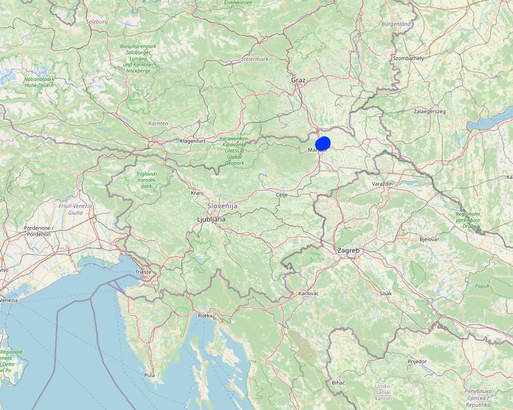
ປະເທດ:
ສະໂນວາເນຍ
ພາກພື້ນ / ລັດ / ແຂວງ:
Jareninski dol, Pernica
ຂໍ້ມູນເພີ່ມເຕີມຂອງສະຖານທີ່:
Vosek
ໃຫ້ລະບຸ ການແຜ່ຂະຫຍາຍ ເຕັກໂນໂລຢີ:
- ແຜ່ຂະຫຍາຍຢ່າງໄວວາໃນພື້ນທີ່
ຖ້າຫາກວ່າເຕັກໂນໂລຢີ ໄດ້ກະຈາຍໄປທົ່ວພື້ນທີ່, ໃຫ້ລະບຸເນື້ອທີ່ ທີ່ຖືກປົກຄຸມ (ເປັນ ກິໂລຕາແມັດ):
137.0
ຖ້າຫາກບໍ່ຮູ້ເນື້ອທີ່ທີ່ແນ່ນອນ, ໃຫ້ລະບຸ ເນື້ອທີ່ໂດຍປະມານ ທີ່ໃກ້ຄຽງ:
- < 0.1 ກິໂລແມັດ2 (10 ເຮັກຕາ)
ສ່ວນຫຼາຍສະຖານທີ່ຕັ້ງຂອງເຕັກໂນໂລຢີ ແມ່ນ ຢູ່ໃນເຂດພື້ນທີ່ສະຫງວນບໍ?
ບໍ່ແມ່ນ
Map
×2.6 ວັນທີໃນການຈັດຕັ້ງປະຕິບັດ
ຖ້າຫາກວ່າ ບໍ່ຮູ້ຈັກ ປີທີ່ຊັດເຈນ ແມ່ນໃຫ້ປະມານ ວັນທີເອົາ:
- ຕໍ່າກວ່າ 10 ປີ ຜ່ານມາ (ມາເຖິງປະຈຸບັນ)
2.7 ການນໍາສະເໜີ ເຕັກໂນໂລຢີ
- due to the legislative requirements of agricultural and water policy.
3. ການໃຈ້ແຍກ ເຕັກໂນໂລຢີ ໃນການຄຸ້ມຄອງ ດິນແບບຍືນຍົງ
3.1 ຈຸດປະສົງຫຼັກ (ຫຼາຍ) ຂອງເຕັກໂນໂລຢີ
- ຫຼຸດຜ່ອນ, ປ້ອງກັນ, ຟື້ນຟູ ການເຊື່ອມໂຊມຂອງດິນ
- ການອະນຸລັກ ລະບົບນິເວດ
- ປົກປັກຮັກສານໍ້າ / ນໍ້າພື້ນທີ່ - ປະສົມປະສານກັບ ເຕັກໂນໂລຢີອື່ນໆ
- ປົກປັກຮັກສາ / ການປັບປຸງຊີວະນາໆພັນ
3.2 ປະເພດການນໍາໃຊ້ທີ່ດິນ ໃນປະຈຸບັນ() ທີ່ເຕັກໂນໂລຢີ ໄດ້ຖືກນໍາໃຊ້
ການນຳໃຊ້ທີ່ດິນ ປະສົມພາຍໃນພື້ນທີ່ດຽວກັນ:
ບໍ່ແມ່ນ

ດິນທີ່ປູກພືດ
- ການປູກພືດປະຈໍາປີ
- ພືດຢືນຕົ້ນ (ບໍ່ແມ່ນໄມ້)
ການປູກພືດປະຈຳປີ - ລະບຸປະເພດພືດ:
- ພືດອາຫານສັດ - ປະເພດຫຍ້າ
- ພທດອາຫານສັດ- ປະເພດດອກ
- ພືດອາຫານສັດ-ປະເພດຫຍ້າ
ການປູກພືດຢືນຕົ້ນ(ບໍ່ແມ່ນໄມ້ໄມ້ຢືນຕົ້ນ) - ໃຫ້ລະບຸປະເພດພືດ:
- ພືດອາຫານສັດ-ປະເພດຫຍ້າ
- fodder crops - legumes, clover
ຈໍານວນ ລະດູການ ປູກໃນປີໜຶ່ງ:
- 1
ມີການເຝືກປູກພືດແບບສັບຫວ່າງບໍ່?
ແມ່ນ
ຖ້າມີ, ໃຫ້ລະບຸວ່າປູກພືດຊະນິດໃດທີ່ປູກສັບຫວ່າງ:
A mix of grasses, clovers, and alfalfa.
ມີການເຝືກປູກພືດແບບໝູນວຽນບໍ່?
ບໍ່ແມ່ນ
ຄວາມຄິດເຫັນ:
The area is generally classified as agricultural land but functions as a buffer zone along water bodies. Fodder crops are typically grown and either harvested for feed or mulched. In some cases, the area may be used for grazing livestock, although this is relatively rare.
3.3 ການນຳໃຊ້ທີ່ດິນ ມີການປ່ຽນແປງຍ້ອນການຈັດຕັ້ງທົດລອງເຕັກໂນໂລຢີ ແມ່ນບໍ່?
ການນຳໃຊ້ທີ່ດິນ ມີການປ່ຽນແປງຍ້ອນການຈັດຕັ້ງທົດລອງເຕັກໂນໂລຢີ ແມ່ນບໍ່?
- ແມ່ນ (ກະລຸນາຕື່ມໃສ່ ຄຳຖາມຂ້າງລຸ່ມນີ້ກ່ຽວກັບການນຳໃຊ້ທີ່ດິນ ກ່ອນການທົດລອງເຕັກໂນໂລຢີ)
ການນຳໃຊ້ທີ່ດິນ ປະສົມພາຍໃນພື້ນທີ່ດຽວກັນ:
ບໍ່ແມ່ນ
ດິນທີ່ປູກພືດ
- ການປູກພືດປະຈໍາປີ
ການປູກພືດປະຈຳປີ - ລະບຸປະເພດພືດ:
- ທັນຍາພືດ-ເຂົ້າບາເລ້
- ທັນຍາພືດ-ສາລີ
- ທັນຍາພືດ - ເຂົ້າສາລີ (ລະດູ ໜາວ)
ມີການເຝືກປູກພືດແບບສັບຫວ່າງບໍ່?
ບໍ່ແມ່ນ
ມີການເຝືກປູກພືດແບບໝູນວຽນບໍ່?
ແມ່ນ
ຖ້າແມ່ນ, ໃຫ້ລະບຸແຈ້ງ:
General crop rotation is practiced, typically alternating between cereals and maize.
3.4 ການສະໜອງນ້ຳ
ການສະໜອງນໍ້າ ໃນພື້ນທີ່ ທີ່ໄດ້ນໍາໃຊ້ ເຕັກໂນໂລຢີ:
- ນໍ້າຝົນ
3.5 ການນໍາໃຊ້ເຕັກໂນໂລຢີ ທີ່ຢູ່ໃນກຸ່ມການຄຸ້ມຄອງ ທີ່ດິນແບບຍືນຍົງ
- ການປັບປຸງດິນ / ພືດຄຸມດິນ
- ການຄຸ້ມຄອງນໍ້າໜ້າດິນ (ນ້ຳຈາກພຸ, ແມ່ນໍ້າ, ທະເລສາບ, ທະເລ)
- ການຄຸ້ມຄອງ ແລະ ປ້ອງກັນເຂດດິນທາມ
3.6 ມາດຕະການ ການຄຸ້ມຄອງ ທີ່ດິນແບບຍືນຍົງ ປະກອບດ້ວຍ ເຕັກໂນໂລຢີ

ມາດຕະການ ທາງດ້ານພືດພັນ
- V1: ເປັນໄມ້ຢືນຕົ້ນ ແລະ ການປົກຫຸ້ມຂອງໄມ້ພຸ່ມ
- V2: ຫຍ້າ ແລະ ພືດສະໝູນໄພທີ່ເປັນໄມ້ຢືນຕົ້ນ
- V5: ອື່ນໆ
ຄວາມຄິດເຫັນ:
It is considered a vegetative measure because it relies primarily on the establishment and management of permanent vegetation such as grasses, legumes (e.g., clover, alfalfa), shrubs, and trees.
3.7 ປະເພດດິນເຊື່ອມໂຊມ ຫຼັກທີ່ໄດ້ນໍາໃຊ້ ເຕັກໂນໂລຢີ

ດິນເຊາະເຈື່ອນ ໂດຍນໍ້າ
- Wt: ການສູນເສຍຊັ້ນໜ້າດິນ / ການເຊາະເຈື່ອນຜິວໜ້າດິນ
- Wr: ແຄມຕາຝັ່ງເຈື່ອນ
- Wo: ຜົນກະທົບ ຂອງການເຊື່ອມໂຊມ ຕໍ່ພື້ນທີ່ພາຍນອກ

ການເຊື່ອມໂຊມ ຂອງດິນ ທາງເຄມີ
- Cn: ຄວາມອຸດົມສົມບູນ ລົດໜ້ອຍຖອຍລົງ ແລະ ສານອິນຊີວັດຖຸລົດລົງ (ບໍ່ແມ່ນສາເຫດມາຈາກການເຊາະເຈື່ອນ)

ການເຊື່ອມໂຊມ ທາງຊີວະພາບ
- Bc: ການຫຼຸດຜ່ອນການປົກຫຸ້ມຂອງພືດ
- Bh: ການສູນເສຍ ທີ່ຢູ່ອາໃສ ຂອງສິ່ງທີ່ມີຊິວິດ
- Bs: ຄຸນນະພາບ / ການອັດແໜ້ນ ຂອງສາຍພັນຫຼຸດລົງ

ການເຊື່ອມໂຊມ ຂອງນໍ້າ
- HW: ການຫຼຸດຜ່ອນ ຄວາມສາມາດ ໃນການປ້ອງກັນພື້ນທີ່ດິນທາມ
3.8 ການປ້ອງກັນ, ການຫຼຸດຜ່ອນ, ຫຼືການຟື້ນຟູຂອງການເຊື່ອມໂຊມຂອງດິນ
ໃຫ້ລະບຸ ເປົ້າໝາຍ ເຕັກໂນໂລຢີ ທີ່ພົວພັນ ກັບຄວາມເຊື່ອມໂຊມຂອງດິນ:
- ປ້ອງກັນການເຊື່ອມໂຊມຂອງດິນ
- ຫຼຸດຜ່ອນການເຊື່ອມໂຊມຂອງດິນ
4. ຂໍ້ກໍາໜົດ, ກິດຈະກໍາການປະຕິບັດ, ວັດຖຸດິບ, ແລະຄ່າໃຊ້ຈ່າຍ
4.1 ເຕັກນິກ ໃນການແຕ້ມແຜນວາດ ເຕັກໂນໂລຢີ
ຄຸນລັກສະນະ ຂອງເຕັກນິກ (ທີ່ກ່ຽວຂ້ອງ ກັບການແຕ້ມແຜນວາດ ທາງດ້ານເຕັກນີກ):
Riparian buffer strips are protected zones established along watercourses to reduce agricultural impacts on soil and water quality. These strips remain part of the agricultural land base and may be managed as grassland, limited arable land, or grazing areas. However, to maintain their protective function, specific agricultural inputs and activities are restricted within these areas. If the buffer strips are not properly maintained, they are excluded from the system of agricultural land in use and become ineligible for any subsidies.
Management and Activity Restrictions (applicable to buffer strips only):
Soil tillage: Deep ploughing is prohibited; only shallow (low) tillage is permitted for maintenance and sowing.
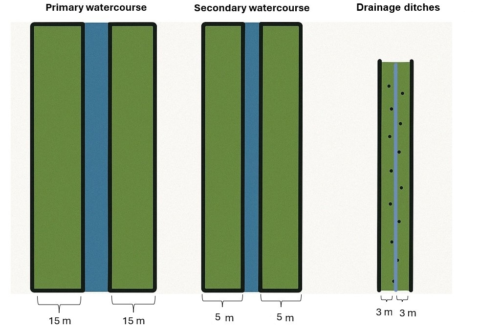
Buffer widths (according to the Water Act):
- 15 m along primary watercourses
- 5 m along secondary watercourses
- 3 m along drainage ditches
Vegetation allowed: Grass, grass-clover mixtures, clover-grass mixtures, alfalfa, clover, native shrubs, and trees.
Fertilization: Application of mineral and organic fertilizers is prohibited. Storage or disposal of manure is not allowed. Natural manure from grazing animals is tolerated.
Plant protection products: The use of pesticides has been prohibited in buffer strips since 2002.
Livestock grazing: Grazing is allowed but must not damage the structure of the water body. Animals may drink from the watercourse at designated points, but supplementary feeding is not permitted within the strip.
ຜູ້ຂຽນ:
Gregor Kramberger
ວັນທີ:
18/04/2025
ຜູ້ຂຽນ:
Lorna J. Cole, Jenni Stockan, Rachel Helliwell
ວັນທີ:
01/07/2020
4.2 ຂໍ້ມູນທົ່ວໄປກ່ຽວກັບການຄິດໄລ່ປັດໃຈຂາເຂົ້າໃນການຜະລິດ ແລະ ມູນຄ່າອື່ນໆ
ລະບຸ ວິທີການ ຄຳໃຊ້ຈ່າຍ ແລະ ປັດໄຈນໍາເຂົ້າ ທີ່ໄດ້ຄິດໄລ່:
- ຕໍ່ພື້ນທີ່ ທີ່ໄດ້ຈັດຕັ້ງປະຕິບັດ ເຕັກໂນໂລຢີ
ໃຫ້ລະບຸຫົວໜ່ວຍ ຂະໜາດ ແລະ ເນື້ອທີ່:
31,2 hectares
ສະກຸນເງິນອື່ນໆ / ປະເທດອື່ນໆ (ລະບຸ):
EUR
ຖ້າກ່ຽວຂ້ອງ, ໃຫ້ລະບຸອັດຕາແລກປ່ຽນຈາກ USD ເປັນສະກຸນເງິນທ້ອງຖິ່ນ (ເຊັ່ນ: 1 USD = 79.9 Brazilian Real): 1 USD =:
0.87
ລະບຸ ຄ່າຈ້າງ ຄ່າແຮງງານສະເລ່ຍ ຕໍ່ ວັນ:
114
4.3 ການສ້າງຕັ້ງກິດຈະກໍາ
| ກິດຈະກໍາ | Timing (season) | |
|---|---|---|
| 1. | Purchase grass seed mixture | 1st year |
| 2. | Pre-sowing preparation and sowing | 1st year |
ຄວາມຄິດເຫັນ:
Select grass species or mixtures adapted to local soil and climatic conditions. Minimal soil disturbance recommended; shallow cultivation to ensure proper seed-soil contact.
4.4 ຕົ້ນທຶນ ແລະ ປັດໄຈຂາເຂົ້າທີ່ຈໍາເປັນໃນຈັດຕັ້ງປະຕິບັດ
| ລະບຸ ປັດໃຈ ນໍາເຂົ້າ ໃນການຜະລີດ | ຫົວໜ່ວຍ | ປະລິມານ | ຕົ້ນທຶນ ຕໍ່ຫົວໜ່ວຍ | ຕົ້ນທຶນທັງໝົດ ຂອງປັດໃຈຂາເຂົ້າ ໃນການຜະລິດ | % ຂອງຕົ້ນທຶນທັງໝົດ ທີ່ຜູ້ນໍາໃຊ້ທີ່ດິນ ໃຊ້ຈ່າຍເອງ | |
|---|---|---|---|---|---|---|
| ແຮງງານ | Own labor | hour | 3.0 | 9.0 | 27.0 | 100.0 |
| ແຮງງານ | Pre-sowing preparation and sowing | hour | 3.0 | 35.0 | 105.0 | 100.0 |
| ວັດສະດຸໃນການປູກ | Grass seed mixture | kg/ha | 16.412 | 5.6 | 91.91 | 100.0 |
| ຕົ້ນທຶນທັງໝົດ ໃນການຈັດຕັ້ງປະຕິບັດ ເຕັກໂນໂລຢີ | 223.91 | |||||
| ຄ່າໃຊ້ຈ່າຍທັງໝົດ ສຳລັບການສ້າງຕັ້ງເຕັກໂນໂລຢີ ເປັນສະກຸນເງີນໂດລາ | 257.37 | |||||
ຄວາມຄິດເຫັນ:
Labor and pre-sowing preparation and sowing also include travel time between sites. The total size of the farm is 31,2 hectares. An area of 4103 m² falls under the restricted buffer strip zone at his farm.
4.5 ບໍາລຸງຮັກສາ / ແຜນຈັດຕັ້ງປະຕິບັດ ກິດຈະກໍາ
| ກິດຈະກໍາ | ໄລຍະເວລາ / ຄວາມຖີ່ | |
|---|---|---|
| 1. | Mulching/mowing | 2 times per year |
| 2. | Pruning and clearing of overgrowth | 1 time, winter time |
ຄວາມຄິດເຫັນ:
4103 m² of agricultural land represents the buffer strips that the farmer actively manages and maintains. Pruning or cutting of woody vegetation, such as trees or shrubs, when they begin to encroach on agricultural land near the riverbank. Farmers typically carry out this work in winter, but it is difficult to estimate the cost, as it can vary significantly depending on the extent of overgrowth.
4.6 ຄ່າໃຊ້ຈ່າຍ ແລະ ປັດໄຈນໍາເຂົ້າທີ່ຈໍາເປັນສໍາລັບການບໍາລຸງຮັກສາກິດຈະກໍາ / ແຜນປະຕິບັດ (ຕໍ່ປີ)
| ລະບຸ ປັດໃຈ ນໍາເຂົ້າ ໃນການຜະລີດ | ຫົວໜ່ວຍ | ປະລິມານ | ຕົ້ນທຶນ ຕໍ່ຫົວໜ່ວຍ | ຕົ້ນທຶນທັງໝົດ ຂອງປັດໃຈຂາເຂົ້າ ໃນການຜະລິດ | % ຂອງຕົ້ນທຶນທັງໝົດ ທີ່ຜູ້ນໍາໃຊ້ທີ່ດິນ ໃຊ້ຈ່າຍເອງ | |
|---|---|---|---|---|---|---|
| ແຮງງານ | Mulching/mowing | hours | 6.0 | 32.0 | 192.0 | 100.0 |
| ແຮງງານ | Pruning and clearing of overgrowth | hours | 4.0 | 4.5 | 18.0 | 100.0 |
| ແຮງງານ | Own labor | hours | 10.0 | 9.0 | 90.0 | 100.0 |
| ຕົ້ນທຶນທັງໝົດ ທີ່ໃຊ້ໃນການບໍາລຸງຮັກສາ ເຕັກໂນໂລຢີ | 300.0 | |||||
| ຄ່າໃຊ້ຈ່າຍທັງໝົດ ສຳລັບການບົວລະບັດຮກສາເຕັກໂນໂລຢີ ເປັນສະກຸນເງີນໂດລາ | 344.83 | |||||
ຄວາມຄິດເຫັນ:
Opportunity costs were calculated based on the loss of arable land due to the establishment of buffer zones in 2024 on Farm Ropic (total farm size: 32,2 ha, of which 28,6 ha is arable land). The planned crop rotation for that year included wheat, oil pumpkins, barley, and maize. The income foregone represents the estimated revenue that could have been generated from these crops on the area now designated as buffer strips (a total of 4103 m² of arable land).
The estimated income losses by crop type are:
Winter wheat: 113.52 €
Oil pumpkin: 396.80 €
Winter barley: 120.60 €
Grain maize: 68.04 €.
4.7 ປັດໄຈ ທີ່ສໍາຄັນ ທີ່ສົ່ງຜົນກະທົບ ຕໍ່ຄ່າໃຊ້ຈ່າຍ
ໃຫ້ອະທິບາຍ ປັດໃຈ ທີ່ສົ່ງຜົນກະທົບ ຕໍ່ຕົ້ນທຶນ ໃນການຈັດຕັ້ງປະຕິບັດ:
Exact costs are difficult to estimate as they depend heavily on the specific location. If regular maintenance, such as mulching/mowing, is carried out, annual costs remain low, and pruning and clearing of overgrowth work is likely unnecessary. Costs are calculated for farm Ropič.
5. ສະພາບແວດລ້ອມທໍາມະຊາດ ແລະ ມະນຸດ
5.1 ອາກາດ
ປະລິມານນໍ້າຝົນປະຈໍາປີ
- < 250 ມີລິແມັດ
- 251-500 ມີລິແມັດ
- 501-750 ມີລິແມັດ
- 751-1,000 ມີລິແມັດ
- 1,001-1,500 ມີລິແມັດ
- 1,501-2,000 ມີລິແມັດ
- 2,001-3,000 ມີລິແມັດ
- 3,001-4,000 ມີລິແມັດ
- > 4,000 ມີລິແມັດ
ໃຫ້ລະບຸສະເລ່ຍ ປະລິມານນໍ້າຝົນຕົກປະຈໍາປີ ເປັນມິນລິແມັດ (ຖ້າຫາກຮູ້ຈັກ):
1032.00
ຂໍ້ມູນສະເພາະ / ຄວາມເຫັນກ່ຽວກັບ ປະລິມານນໍ້າຝົນ:
The most precipitation falls in summer, the months with the highest average precipitation are August and September, the least precipitation falls in winter, in January and February at least, and in principle more precipitation falls in autumn than in spring.
ໃຫ້ລະບຸ ຊື່ສະຖານີ ອຸຕຸນິຍົມ ເພື່ອເປັນຂໍ້ມູນອ້າງອີງ:
Jareninski Vrh (1991-2020)
ເຂດສະພາບອາກາດກະສິກໍາ
- ເຄີ່ງຄວາມຊຸ່ມ
The average annual air temperature at Jareninski Vrh during the reference period 1991–2020 was 10.1 °C.
5.2 ພູມິປະເທດ
ຄ່າສະເລ່ຍ ຄວາມຄ້ອຍຊັນ:
- ພື້ນທີ່ຮາບພຽງ (0-2%)
- ອ່ອນ (3-5 %)
- ປານກາງ (6-10 %)
- ມ້ວນ (11-15 %)
- ເນີນ(16-30%)
- ໍຊັນ (31-60%)
- ຊັນຫຼາຍ (>60%)
ຮູບແບບຂອງດິນ:
- ພູພຽງ / ທົ່ງພຽງ
- ສັນພູ
- ເປີ້ນພູ
- ເນີນພູ
- ຕີນພູ
- ຮ່ອມພູ
ເຂດລະດັບສູງ:
- 0-100 ແມັດ a.s.l.
- 101-500 ແມັດ a.s.l.
- 501-1,000 ແມັດ a.s.l.
- 1,001-1,500 ແມັດ a.s.l.
- 1,501-2,000 ແມັດ a.s.l.
- 2,001-2,500 ແມັດ a.s.l.
- 2,501-3,000 ແມັດ a.s.l.
- 3,001-4,000 ແມັດ a.s.l.
- > 4,000 ແມັດ a.s.l.
ໃຫ້ລະບຸ ເຕັກໂນໂລຢີ ທີ່ໄດ້ຖືກນຳໃຊ້:
- ລັກສະນະກີ່ວ
ຄຳເຫັນ ແລະ ຂໍ້ມູນສະເພາະ ເພີ່ມເຕີມ ກ່ຽວກັບ ພູມີປະເທດ:
There are depressions, settlements are in the valley, concave type.
5.3 ດິນ
ຄວາມເລິກ ຂອງດິນສະເລ່ຍ:
- ຕື້ນຫຼາຍ (0-20 ຊັງຕີແມັດ)
- ຕື້ນ (21-50 ຊຕມ)
- ເລີກປານກາງ (51-80 ຊຕມ)
- ເລິກ (81-120 ຊມ)
- ເລິກຫຼາຍ (> 120 cm)
ເນື້ອດິນ (ໜ້າດິນ):
- ປານກາງ (ດິນໜຽວ, ດິນໂຄນ)
ເນື້ອດິນ (ເລິກຈາກໜ້າດິນ ລົງໄປຫຼາຍກວ່າ 20 ຊັງຕິແມັດ):
- ປານກາງ (ດິນໜຽວ, ດິນໂຄນ)
ຊັ້ນອິນຊີວັດຖຸ ເທິງໜ້າດິນ:
- ສູງ (> 3 %)
5.4 ມີນໍ້າ ແລະ ຄຸນນະພາບ
ລະດັບ ນໍ້າໃຕ້ດິນ:
5-50 ແມັດ
ການມີນໍ້າ ເທິງໜ້າດິນ:
ດີ
ຄຸນນະພາບນໍ້າ (ບໍ່ມີການບໍາບັດ):
ນຳໃຊ້ເຂົ້າໃນການຜະລິດກະສິກໍາພຽງຢ່າງດຽງ (ຊົນລະປະທານ)
ຄຸນນະພາບນ້ຳ ໝາຍເຖີງ:
ນ້ຳໜ້າດິນ
ມີບັນຫາ ກ່ຽວກັບນໍ້າເຄັມບໍ່?
ບໍ່ແມ່ນ
ເກີດມີນໍ້າຖ້ວມ ໃນພື້ນທີ່ບໍ່?
ແມ່ນ
ເປັນປົກກະຕິ:
ຕອນ
ຄວາມຄິດເຫັນ ແລະ ຂໍ້ກໍານົດ ເພີ່ມເຕີມ ກ່ຽວກັບ ຄຸນນະພາບ ແລະ ປະລິມານ ຂອງນ້ຳ:
Hydromelioration was carried out in the area, a drainage system and water retention systems (e.g. ponds and basins) were arranged.
5.5 ຊີວະນາໆພັນ
ຄວາມຫຼາກຫຼາຍ ທາງສາຍພັນ:
- ປານກາງ
ຄວາມຫຼາກຫຼາຍ ທາງດ້ານ ທີ່ຢູ່ອາໃສ ຂອງສິ່ງທີ່ມີຊີວິດ:
- ປານກາງ
5.6 ຄຸນລັກສະນະ ຂອງຜູ້ນໍາໃຊ້ທີ່ດິນ ທີ່ໄດ້ນໍາໃຊ້ເຕັກໂນໂລຢີ
ຢູ່ປະຈຳ ຫຼື ເຄື່ອນຍ້າຍຕະຫຼອດ:
- ບໍ່ເຄື່ອນໄຫວ
ລະບົບ ການຕະຫຼາດ ແລະ ຜົນຜະລິດ:
- ການຄ້າ / ຕະຫຼາດ
ລາຍຮັບ ທີ່ບໍ່ໄດ້ມາຈາກ ການຜະລິດ ກະສິກໍາ:
- 10-50 % ຂອງລາຍຮັບທັງໝົດ
ລະດັບຄວາມຮັ່ງມີ:
- ສະເລ່ຍ
ບຸກຄົນ ຫຼື ກຸ່ມ:
- ບຸກຄົນ / ຄົວເຮືອນ
ລະດັບ ການຫັນເປັນກົນຈັກ:
- ເຄື່ອງກົນຈັກ
ເພດ:
- ຜູ້ຊາຍ
ອາຍຸ ຂອງຜູ້ນໍາໃຊ້ທີ່ດິນ:
- ໄວກາງຄົນ
5.7 ເນື້ອທີ່ສະເລ່ຍຂອງດິນ ທີ່ຜູ້ນຳໃຊ້ທີ່ດິນ ໃຊ້ເຮັດເຕັກໂນໂລຢີ
- <0.5 ເຮັກຕາ
- 0.5-1 ເຮັກຕາ
- 1-2 ເຮັກຕາ
- 2-5 ເຮັກຕາ
- 5-15 ເຮັກຕາ
- 15-50 ເຮັກຕາ
- 50-100 ເຮັກຕາ
- 100-500 ເຮັກຕາ
- 500-1,000 ເຮັກຕາ
- 1,000-10,000 ເຮັກຕາ
- > 10,000 ເຮັກຕາ
ຖືໄດ້ວ່າ ເປັນຂະໜາດນ້ອຍ, ກາງ ຫຼື ໃຫຍ່ (ອີງຕາມເງື່ອນໄຂ ສະພາບຄວາມເປັນຈິງ ຂອງທ້ອງຖີ່ນ)? :
- ຂະໜາດກາງ
5.8 ເຈົ້າຂອງທີ່ດິນ, ສິດໃຊ້ທີ່ດິນ, ແລະ ສິດທິການນໍາໃຊ້ນໍ້າ
ເຈົ້າຂອງດິນ:
- ບຸກຄົນ, ທີ່ມີຕໍາແໜ່ງ
ສິດທິ ໃນການນໍາໃຊ້ທີ່ດິນ:
- ເຊົ່າ
- ບຸກຄົນ
ສິດທິ ໃນການນໍາໃຊ້ນໍ້າ:
- ຊຸມຊົນ (ທີ່ມີການຈັດຕັ້ງ)
ລະບຸ ຊະນິດ:
Based on national legal system.
5.9 ການເຂົ້າເຖິງການບໍລິການ ແລະ ພື້ນຖານໂຄງລ່າງ
ສຸຂະພາບ:
- ທຸກຍາກ
- ປານກາງ
- ດີ
ການສຶກສາ:
- ທຸກຍາກ
- ປານກາງ
- ດີ
ການຊ່ວຍເຫຼືອ ດ້ານວິຊາການ:
- ທຸກຍາກ
- ປານກາງ
- ດີ
ການຈ້າງງານ (ຕົວຢ່າງ, ການເຮັດກິດຈະກໍາອື່ນ ທີ່ບໍ່ແມ່ນ ການຜະລິດກະສິກໍາ):
- ທຸກຍາກ
- ປານກາງ
- ດີ
ຕະຫຼາດ:
- ທຸກຍາກ
- ປານກາງ
- ດີ
ພະລັງງານ:
- ທຸກຍາກ
- ປານກາງ
- ດີ
ຖະໜົນຫົນທາງ ແລະ ການຂົນສົ່ງ:
- ທຸກຍາກ
- ປານກາງ
- ດີ
ການດື່ມນໍ້າ ແລະ ສຸຂາພິບານ:
- ທຸກຍາກ
- ປານກາງ
- ດີ
ການບໍລິການ ທາງດ້ານການເງິນ:
- ທຸກຍາກ
- ປານກາງ
- ດີ
6. ຜົນກະທົບ ແລະ ລາຍງານສະຫຼຸບ
6.1 ການສະແດງຜົນກະທົບ ພາຍໃນພື້ນທີ່ ທີ່ໄດ້ຈັດຕັ້ງປະຕິບັດ ເຕັກໂນໂລຢີ
ຜົນກະທົບທາງເສດຖະກິດສັງຄົມ
ການຜະລິດ
ການຜະລິດພືດ
ຄວາມຄິດເຫັນ / ລະບຸແຈ້ງ:
The loss of productive farmland depends on the width of buffer strips and the total farm size. Impact on yield varies depending on the previous land use (e.g., maize, wheat, barley were replaced by permanent vegetation).
ການຜະລິດອາຫານສັດ
ຄວາມຄິດເຫັນ / ລະບຸແຈ້ງ:
Some farmers report that grasses grown in riparian buffer strips can be harvested for hay or grazed by livestock, partially compensating for lost crop land. Dairy or mixed farms benefit more from fodder production.
ເນື້ອທີ່ການຜະລິດ
ຄວາມຄິດເຫັນ / ລະບຸແຈ້ງ:
The implementation of riparian buffer strips directly reduces the production area, as these zones must be permanently maintained with grass, shrubs, or trees instead of crops.
ການຈັດການຄຸ້ມຄອງທີ່ດິນ
ຄວາມຄິດເຫັນ / ລະບຸແຈ້ງ:
Less flexibility in field layout and crop management (without plowing, fertilization, or pesticides). Additional maintenance like mulching and active cultivation area is reduced. Buffer strips create machinery access/driving zones and reduce erosion.
ມີນໍ້າ ແລະ ຄຸນນະພາບ
ນໍ້າດື່ມ ມີຄຸນນະພາບ
ຄວາມຄິດເຫັນ / ລະບຸແຈ້ງ:
They filter agricultural runoff and prevent fertilizers, pesticides and sediments from entering waterways. They reduce nitrate leaching and chemical pollution, improving the quality of groundwater and surface water.
ຄຸນນະພາບ ຂອງນໍ້າ ສໍາລັບລ້ຽງສັດ
ຄວາມຄິດເຫັນ / ລະບຸແຈ້ງ:
They filter pollutants before they reach streams and water sources, improving water quality for grazing animals.
ລາຍໄດ້ ແລະ ຄ່າໃຊ້ຈ່າຍ
ລາຍຮັບ ຈາກການຜະລີດ
ຄວາມຄິດເຫັນ / ລະບຸແຈ້ງ:
The loss of productive land due to buffer strips reduces crop output, affecting farm revenue.
ມີວຽກໜັກ
ຄວາມຄິດເຫັນ / ລະບຸແຈ້ງ:
Farmers need to mow or mulch buffer strips regularly to prevent overgrowth. Sometimes tree maintenance is necessary.
ຜົນກະທົບດ້ານວັດທະນາທໍາສັງຄົມ
ໂອກາດ ໃນການພັກຜ່ອນຢ່ອນໃຈ
ຄວາມຄິດເຫັນ / ລະບຸແຈ້ງ:
Access to water bodies for recreational purposes.
ຜົນກະທົບຕໍ່ລະບົບນິເວດ
ວົງຈອນນໍ້າ / ນໍ້າ
ຄຸນນະພາບນໍ້າ
ຄວາມຄິດເຫັນ / ລະບຸແຈ້ງ:
They filter out nitrates, phosphorus, pesticides, and sediments before they reach water bodies.
ການໄຫຼ ຂອງນໍ້າໜ້າດິນ
ຄວາມຄິດເຫັນ / ລະບຸແຈ້ງ:
They slow surface runoff, increase water infiltration, and reduce the transport of sediments, fertilizers, and pesticides into water bodies.
ດິນ
ການປົກຄຸມຂອງດິນ
ຄວາມຄິດເຫັນ / ລະບຸແຈ້ງ:
They maintaiThey maintain continuous vegetation cover in the zone around the water body.n continuous vegetation cover and reduce soil exposure to erosion.
ການສູນເສຍດິນ
ຄວາມຄິດເຫັນ / ລະບຸແຈ້ງ:
They significantly reduce soil erosion, they stabilize the soil and trap sediment, especially during floods.
ຊີວະນານາພັນ: ສັດ, ພືດ
ການປົກຫຸ້ມຂອງພືດ
ຄວາມຄິດເຫັນ / ລະບຸແຈ້ງ:
Permanent vegetation cover in buffer strips, improving soil stability and biodiversity.
ຄວາມຫຼາກຫຼາຍຂອງພືດ
ຄວາມຄິດເຫັນ / ລະບຸແຈ້ງ:
Increased diversity of grasses, legumes, shrubs, and trees, creating a more resilient ecosystem.
ຄວາມຫຼາກຫຼາຍຂອງສັດ
ຄວາມຄິດເຫັນ / ລະບຸແຈ້ງ:
Riparian buffer strips provide habitat for birds, insects, amphibians, and small mammals, increasing biodiversity and ecological stability.
ຊະນິດທີ່ເປັນປະໂຫຍດ
ຄວາມຄິດເຫັນ / ລະບຸແຈ້ງ:
Increased presence of pollinators, predatory insects, and other beneficial organisms.
ຄວາມຫຼາກຫຼາຍ ທາງດ້ານທີ່ຢູ່ອາໃສ ຂອງສິ່ງທີ່ມີຊີວິດ
ຄວາມຄິດເຫັນ / ລະບຸແຈ້ງ:
With riparian buffer strips we create diverse habitats by introducing a mix of grasses, shrubs, and trees, supporting a wider range of species.
ການຫຼຸດຜ່ອນ ຄວາມສ່ຽງ ຈາກໄພພິບັດ ແລະ ອາກາດປ່ຽນແປງ
ຜົນກະທົບ ຂອງນໍ້າຖ້ວມ
ຄວາມຄິດເຫັນ / ລະບຸແຈ້ງ:
Deep-rooted vegetation stabilizes riverbanks, preventing erosion and minimizing damage during high water events.
ລະບຸ ການປະເມີນຜົນກະທົບ ຕໍ່ສະຖານທີ່ (ການວັດແທກ):
The data provided are not based on direct measurements but are derived from statements by the land user (farmer) and expert judgement from an agricultural adviser. They reflect practical experience and informed estimates rather than measured field data.
6.2 ຜົນກະທົບທາງອ້ອມ ຈາກການນໍາໃຊ້ເຕັກໂນໂລຢີ
ມົນລະພິດ ທາງນໍ້າ / ນໍ້າໄຕ້ດິນ
ຄວາມຄິດເຫັນ / ລະບຸແຈ້ງ:
Due to a significant reduction in the leaching of pollutants, leading to cleaner water sources.
ການປ້ອງກັນ / ຄວາມອາດສາມາດ ການກັ່ນຕອງ
ຄວາມຄິດເຫັນ / ລະບຸແຈ້ງ:
Significant reduction in pollutants as buffer strips trap sediments and filter nutrients and chemicals before reaching watercourses.
ກໍານົດ ການປະເມີນ ຜົນກະທົບທາງນອກ (ການວັດແທກ):
The data provided are not based on direct measurements but are derived from statements by the land user (farmer) and expert judgement from an agricultural adviser. They reflect practical experience and informed estimates rather than measured field data.
6.3 ການປ້ອງກັນ ແລະ ຄວາມບອບບາງ ຂອງເຕັກໂນໂລຢິ ໃນການປ່ຽນແປງສະພາບດິນຟ້າອາກາດ ແລະ ກ່ຽວຂ້ອງກັບອາກາດທີ່ມີການປ່ຽນແປງທີ່ຮຸນແຮງ / ໄພພິບັດທາງທໍາມະຊາດ (ຮັບຮູ້ໄດ້ໂດຍຜູ້ນໍາໃຊ້ທີ່ດິນ)
ການປ່ຽນແປງດິນຟ້າອາກາດ ເທື່ອລະກ້າວ
ການປ່ຽນແປງດິນຟ້າອາກາດ ເທື່ອລະກ້າວ
| ລະດູການ | ເພີ່ມຂື້ນ ຫຼື ຫຼຸດລົງ | ການນໍາໃຊ້ ເຕັກໂນໂລຢີ ສາມາດ ຮັບມື ໄດ້ຄືແນວໃດ? | |
|---|---|---|---|
| ອຸນຫະພູມປະຈໍາປີ | ເພີ່ມຂື້ນ | ປານກາງ | |
| ອຸນຫະພູມລະດູການ | ລະດູຮ້ອນ | ເພີ່ມຂື້ນ | ປານກາງ |
| ອຸນຫະພູມລະດູການ | ລະດູໃບໄມ້ປົ່ງ | ເພີ່ມຂື້ນ | ປານກາງ |
| ອຸນຫະພູມລະດູການ | ລະດູໃບໄມ້ລົ່ນ | ເພີ່ມຂື້ນ | ປານກາງ |
| ອຸນຫະພູມລະດູການ | ລະດູໜາວ | ເພີ່ມຂື້ນ | ປານກາງ |
| ປະລິມານນໍ້າຝົນຕາມລະດູການ | ລະດູຮ້ອນ | ເພີ່ມຂື້ນ | ດີຫຼາຍ |
| ປະລິມານນໍ້າຝົນຕາມລະດູການ | ລະດູໃບໄມ້ປົ່ງ | ເພີ່ມຂື້ນ | ດີຫຼາຍ |
| ປະລິມານນໍ້າຝົນຕາມລະດູການ | ລະດູໃບໄມ້ລົ່ນ | ຫຼຸດລົງ | ປານກາງ |
ອາກາດ ທີ່ກ່ຽວພັນກັບຄວາມຮຸນແຮງ (ໄພພິບັດທາງທໍາມະຊາດ)
ໄພພິບັດທາງອຸຕຸນິຍົມ
| ການນໍາໃຊ້ ເຕັກໂນໂລຢີ ສາມາດ ຮັບມື ໄດ້ຄືແນວໃດ? | |
|---|---|
| ພະຍຸຝົນ | ດີຫຼາຍ |
ໄພພິບັດທາງພູມອາກາດ
| ການນໍາໃຊ້ ເຕັກໂນໂລຢີ ສາມາດ ຮັບມື ໄດ້ຄືແນວໃດ? | |
|---|---|
| ຄື້ນຄວາມອົບອຸ່ນ | ດີ |
ໄພພິບັດທາງອຸທົກກະສາກ
| ການນໍາໃຊ້ ເຕັກໂນໂລຢີ ສາມາດ ຮັບມື ໄດ້ຄືແນວໃດ? | |
|---|---|
| ໂດຍທົ່ວໄປ (ແມ່ນໍ້າ) ນໍ້າຖ້ວມ | ດີຫຼາຍ |
| ນໍ້າຖ້ວມຮູນແຮງ | ດີຫຼາຍ |
6.4 ການວິເຄາະຕົ້ນທຶນ ແລະ ຜົນປະໂຫຍດ
ຈະເຮັດປະໂຫຍດເພື່ອປຽບທຽບກັບຄ່າໃຊ້ຈ່າຍກັບສິ່ງກໍ່ສ້າງ (ຈາກທັດສະນະຂອງຜູ້ນຳໃຊ້ທີ່ດິນ) ໄດ້ແນວໃດ?
ຜົນຕອບແທນ ໃນໄລຍະສັ້ນ:
ຜົນກະທົບທາງລົບເລັກນ້ອຍ
ຜົນຕອບແທນ ໃນໄລຍະຍາວ:
ຜົນກະທົບທາງບວກເລັກນ້ອຍ
ຈະໄດ້ຮັບຜົນປະໂຫຍດເມື່ອປຽບທຽບກັບ / ຄ່າໃຊ້ຈ່າຍໃນການບຳລຸງຮັກສາທີເ່ກີດຂື້ນອິກ (ຈາກທັດສະນະຄະຕິຂອງຜູ້ນຳໃຊ້ທີ່ດິນ) ໄດ້ແນວໃດ?
ຜົນຕອບແທນ ໃນໄລຍະສັ້ນ:
ປານກາງ
ຜົນຕອບແທນ ໃນໄລຍະຍາວ:
ຜົນກະທົບທາງບວກ
ຄວາມຄິດເຫັນ:
Establishment costs are high, including soil preparation, seeding, and potential fencing, while the loss of productive land immediately reduces farm income. Subsidies may offset some costs, but they do not fully compensate for the initial financial impact. In a long-term benefits such as improved soil stability, water quality, and flood protection reduce future expenses. Over time, subsidies, reduced erosion, and potential fodder production help balance the initial investment.
Maintenance costs, such as mowing or mulching and tree maintenance, add labor and equipment expenses, but the absence of fertilizer and pesticide costs helps balance them. Subsidies for maintaining buffer strips further offset these recurrent costs, keeping short-term financial impact neutral. Once vegetation is established, maintenance costs decrease, requiring only occasional mowing or grazing. Over time, benefits like erosion control, improved soil health, and reduced flood damage outweigh the minimal upkeep expenses, making the practice economically sustainable.
6.5 ການປັບຕົວຮັບເອົາເຕັກໂນໂລຢີ
- > 50%
ຖ້າຫາກວ່າມີ, ປະລິມານ (ຈໍານວນຂອງຄົວເຮືອນ / ເນື້ອທີ່ການຄຸ້ມຄອງ):
All farmers in the area must comply with the implementation of riparian buffer strips as part of the GAEC 4 standard under CAP conditionality. This means that all agricultural land users with fields adjacent to watercourses are required to establish and maintain these protective strips, ensuring compliance with national and EU environmental regulations.
ທັງໝົດນັ້ນ ແມ່ນໃຜ ໄດ້ປັບຕົວເຂົ້າ ໃນການນໍາໃຊ້ ເຕັກໂນໂລຢີ, ມີຈັກຄົນ ທີ່ສາມາດເຮັດເອງໄດ້, ຕົວຢ່າງ, ປາດສະຈາກ ການຊ່ວຍເຫຼືອ ທາງດ້ານອຸປະກອນ / ການຈ່າຍເປັນເງິນ?
- 0-10%
6.6 ການປັບຕົວ
ໄດ້ມີການດັດປັບ ເຕັກໂນໂລຢີ ເພື່ອໃຫ້ແທດເໝາະກັບເງື່ອນໄຂ ການປ່ຽນແປງບໍ?
ແມ່ນ
ອື່ນໆ (ລະບຸແຈ້ງ):
CAP
ລະບຸການຮັບຮອງເອົາ ເຕັກໂນໂລຢີ (ການອອກແບບ, ອຸປະກອນການ / ຊະນິດພັນ ແລະ ອື່ນໆ):
The requirements for riparian buffer strips have been updated to align with GAEC 4 conditionality and the EU Strategic Plan Regulation. The establishment of buffer strips is now mandatory along first-order watercourses (15 m wide), second-order watercourses (5 m wide), and drainage ditches (3 m wide).
Within these buffer zones, the use of organic and mineral fertilizers, as well as plant protection products (PPPs), is strictly prohibited. Ploughing is not allowed, but shallow tillage is permitted for maintenance (mowing, mulching, or grazing) and for preparing soil for sowing approved crops.
The buffer strips can be covered with grass, grass-legume mixtures, clover, alfalfa, naturally occurring vegetation, shrubs, or trees. Livestock grazing is permitted but must not alter the structure of the riverbank. Animals cannot be supplementary fed within the buffer zones and must be provided drinking water only at designated, controlled locations in small groups to minimize environmental impact.
6.7 ຈຸດແຂງ / ຂໍ້ດີ / ໂອກາດ ໃນການນໍາໃຊ້ ເຕັກໂນໂລຢີ
| ຈຸດແຂງ / ຂໍ້ດີ / ໂອກາດໃນການນໍາໃຊ້ທີ່ດິນ |
|---|
| Buffer strips stabilize soil and prevent erosion. |
| They reduce the impact of flooding on agricultural land. |
| Less leaching of nutrients and plant protection products into water. |
| Additional turning point and driving path for machines. |
| Establishing and maintaining buffer strips can qualify farmers for financial incentives and support programs. |
| Additional shelters for wildlife. |
| ຈຸດແຂງ / ຈຸດດີ / ໂອກາດ ຈາກທັດສະນະຂອງຜູ້ປ້ອນຂໍ້ມູນ ຫຼື ບຸກຄົນສຳຄັນ |
|---|
| These buffers effectively filter out nutrients, pesticides, and sediments from agricultural runoff, thereby enhancing the quality of nearby water bodies. |
| By stabilizing stream banks, riparian buffers reduce soil erosion, preserving valuable topsoil and maintaining land productivity. |
| They provide critical habitats for various wildlife species, promoting biodiversity and creating wildlife corridors in agricultural landscapes. |
| Riparian buffer strips contribute to ecosystem services like carbon sequestration and pollination, supporting broader environmental goals. |
6.8 ຈຸດອ່ອນ / ຂໍ້ເສຍ / ຄວາມສ່ຽງ ໃນການນໍາໃຊ້ ເຕັກໂນໂລຢີ ແລະ ວິທີການແກ້ໄຂບັນຫາ
| ຈຸດອ່ອນ / ຂໍ້ເສຍ / ຄວາມສ່ຽງໃນມຸມມອງຂອງຜູ້ນໍາໃຊ້ທີ່ດິນ | ມີວິທີການແກ້ໄຂຄືແນວໃດ? |
|---|---|
| The buffer zones are too wide, significantly reducing cultivated land area, which negatively impacts crop yields and farm income. | Increase subsidies and financial incentives for farmers to compensate for the loss of productive land within riparian buffer strips. |
| Maintenance tasks such as mowing, mulching, or controlled grazing require extra labor and resources and establishing buffer strips involves expenses for seeds, machinery, soil preparation, and potential fencing. | Provide additional payments for ongoing maintenance activities or investment support to offset initial establishment costs. |
| The legislation and administrative requirements are complex, involving numerous regulations that farmers find difficult to understand and follow. | Provide more accessible, user-friendly information, along with targeted advisory services and educational programs to help farmers better navigate these rules. |
| ຈຸດອ່ອນ/ຂໍ້ບົກຜ່ອງ/ຄວາມສ່ຽງ ຈາກທັດສະນະຂອງຜູ້ປ້ອນຂໍ້ມູນ ຫຼື ບຸກຄົນສຳຄັນ | ມີວິທີການແກ້ໄຂຄືແນວໃດ? |
|---|---|
| In certain conditions, the redirected flow of water due to buffer strips may weaken streambanks, leading to erosion and land loss. | Designing buffer zones with appropriate vegetation, width and adapted to local conditions, and regularly monitoring the situation. |
| Over time, buffer strips can become saturated with nutrients, reducing their effectiveness and possibly turning them into sources of pollution. | Regular vegetation management, harvesting or removal of biomass to prevent nutrient accumulation. Crop rotation or periodic rejuvenation of buffer zone vegetation to maintain its filtering capacity. |
| Proper upkeep involves tasks like weed control, pruning, replanting, and protection against wildlife, increasing the workload for farmers. | Provide farmers with targeted financial support or subsidies for maintenance tasks, promote low-maintenance vegetation species, and offer technical assistance or training in efficient management practices. |
| Initial setup requires investment in planting, while ongoing maintenance demands additional labor and resources. | Offer financial incentives, subsidies, or cost-sharing programs to cover initial establishment expenses, and provide ongoing support or training to minimize labor and maintenance costs. |
7. ເອກະສານອ້າງອີງ ແລະ ການເຊື່ອມຕໍ່
7.1 ວິທີການ / ແຫຼ່ງຂໍ້ມູນ
- ການສໍາພາດ ຜູ້ນໍາໃຊ້ທີ່ດິນ
1 (Andrej Ropič, farmer)
- ສໍາພາດ ຊ່ຽວຊານ ການຄຸ້ມຄອງ ດິນແບບຍືນຍົງ
2 (Chamber of Agriculture and Forestry of Slovenia (KGZS) – Institute of Agriculture and Forestry Maribor; Tamara Korošec and Timotej Horvat)
- ການລວບລວມ ບົດລາຍງານ ແລະ ເອກະສານ ອື່ນໆ ທີ່ມີຢູ່ແລ້ວ
CAP and Slovenian Strategic Plan 2023-2027.
ເມື່ອໃດທີ່ໄດ້ສັງລວມຂໍ້ມູນ (ຢູ່ພາກສະໜາມ)?
17/01/2023
ຄວາມຄິດເຫັນ:
Visit to the farm and farmer interview.
7.2 ເອກກະສານອ້າງອີງທີ່ເປັນບົດລາຍງານ
ຫົວຂໍ້, ຜູ້ຂຽນ, ປີ, ISBN:
Cole, L. J., Stockan, J., & Helliwell, R. (2020). Managing riparian buffer strips to optimise ecosystem services: A review. Agriculture, Ecosystems & Environment, 296, 106891.
ມີຢູ່ໃສ?ມູນຄ່າເທົ່າໃດ?
https://doi.org/10.1016/j.agee.2020.106891
ຫົວຂໍ້, ຜູ້ຂຽນ, ປີ, ISBN:
Macleod, C. J. A., Haygarth, P. M., et al. (2022). Impacts of different vegetation in riparian buffer strips on runoff and suspended sediment loss. Environmental Research Communications, 4(1), 015001.
ມີຢູ່ໃສ?ມູນຄ່າເທົ່າໃດ?
https://doi.org/10.1088/2515-7620/ac3c2b
ຫົວຂໍ້, ຜູ້ຂຽນ, ປີ, ISBN:
Dlamini, J. C., Cardenas, L. M., Tesfamariam, E. H., Dunn, R. M., Loick, N., Charteris, A. F., Cocciaglia, L., Vangeli, S., Blackwell, M. S. A., Upadhayay, H. R., et al. (2022). Riparian buffer strips influence nitrogen losses as nitrous oxide and leached N from upslope permanent pasture. Agriculture, Ecosystems &
ມີຢູ່ໃສ?ມູນຄ່າເທົ່າໃດ?
https://doi.org/10.1016/j.agee.2022.108031
ຫົວຂໍ້, ຜູ້ຂຽນ, ປີ, ISBN:
Lešnik, T., Bogovič, D., Pokupec, D., & Borec, A. (2024). The impact of riparian zones along rivers under the new CAP in Slovenia. Journal of Central European Agriculture, 25(4), 1185–1192.
ມີຢູ່ໃສ?ມູນຄ່າເທົ່າໃດ?
https://doi.org/10.5513/JCEA01/25.4.4348
7.3 ເຊື່ອມຕໍ່ກັບຂໍ້ມູນທີ່ກ່ຽວຂ້ອງໂດຍກົງ
ຫົວຂໍ້ / ພັນລະນາ:
Ministry of Agriculture, Forestry and Food. (2024). Unified Application 2024: Guidelines for the implementation of interventions under the Strategic Plan of the Common Agricultural Policy 2023–2027. Ljubljana, Slovenia.
URL:
https://www.kgzs.si/uploads/eiv24/NAVODILA%201/00_VELIKA_NAVODILA_2024_-_CELOTA_-_28_5_24.pdf
ຂໍ້ມູນການເຊື່ອມຕໍ່ ແລະ ເນື້ອໃນ
ຂະຫຍາຍທັງໝົດ ຍຸບທັງໝົດການເຊື່ອມຕໍ່
ບໍ່ມີຂໍ້ມູນການເຊື່ອມຕໍ່
ເນື້ອໃນ
ບໍ່ມີເນື້ອໃນ