Detention ponds [ເຢຍລະມັນ]
- ການສ້າງ:
- ປັບປູງ:
- ຜູ້ສັງລວມຂໍ້ມູນ: Felix Witing
- ບັນນາທິການ: Michael Strauch, Mona Pauer
- ຜູ້ທົບທວນຄືນ: William Critchley, Rima Mekdaschi Studer
Rückhaltebecken
technologies_6265 - ເຢຍລະມັນ
ເບິ່ງພາກສ່ວນ
ຂະຫຍາຍທັງໝົດ ຍຸບທັງໝົດ1. ຂໍ້ມູນທົ່ວໄປ
1.2 ຂໍ້ມູນ ການຕິດຕໍ່ພົວພັນ ຂອງບຸກຄົນທີ່ສໍາຄັນ ແລະ ສະຖາບັນ ທີ່ມີສ່ວນຮ່ວມ ໃນການປະເມີນເອກກະສານ ເຕັກໂນໂລຢີ
ຜຸ້ຊ່ຽວຊານ ດ້ານການຄຸ້ມຄອງ ທີ່ດິນແບບຍືນຍົງ:
ຜຸ້ຊ່ຽວຊານ ດ້ານການຄຸ້ມຄອງ ທີ່ດິນແບບຍືນຍົງ:
ຜຸ້ຊ່ຽວຊານ ດ້ານການຄຸ້ມຄອງ ທີ່ດິນແບບຍືນຍົງ:
Schürz Christoph
Helmholtz Centre for Environmental Research (UFZ)
ເຢຍລະມັນ
ຊື່ໂຄງການ ທີ່ອໍານວຍຄວາມສະດວກ ໃນການສ້າງເອກກະສານ/ປະເມີນ ເຕັກໂນໂລຢີ (ຖ້າກ່ຽວຂ້ອງ)
OPtimal strategies to retAIN and re-use water and nutrients in small agricultural catchments across different soil-climatic regions in Europe (OPTAIN)ຊື່ສະຖາບັນ (ຫຼາຍສະຖາບັນ) ທີ່ອໍານວຍຄວາມສະດວກ ໃນການສ້າງເອກກະສານ / ປະເມີນ ເຕັກໂນໂລຢີ (ຖ້າກ່ຽວຂ້ອງ)
Helmholtz Centre for Environmental Research (UFZ) - ເຢຍລະມັນ1.3 ເງື່ອນໄຂ ກ່ຽວກັບ ການນໍາໃຊ້ຂໍ້ມູນເອກະສານ ທີ່ສ້າງຂື້ນ ໂດຍຜ່ານ ອົງການພາບລວມຂອງໂລກ ທາງດ້ານແນວທາງ ແລະ ເຕັກໂນໂລຢີ ຂອງການອານຸລັກ ທໍາມະຊາດ (WOCAT)
ຜູ້ປ້ອນຂໍ້ມູນ ແລະ ບຸກຄົນສຳຄັນ ທີ່ໃຫ້ຂໍ້ມູນ (ຫຼາຍ) ຍິນຍອມ ຕາມເງື່ອນໄຂ ໃນການນຳໃຊ້ຂໍ້ມູນ ເພື່ອສ້າງເປັນເອກກະສານຂອງ WOCAT:
ແມ່ນ
1.4 ແຈ້ງການວ່າ ດ້ວຍຄວາມຍືນຍົງຂອງ ເຕັກໂນໂລຢີ
ການນໍາໃຊ້ ເຕັກໂນໂລຢີ ດັ່ງກ່າວໄດ້ອະທິບາຍ ເຖິງບັນຫາ ກ່ຽວກັບ ການເຊື່ອມໂຊມຂອງດິນບໍ? ຖ້າບໍ່ດັ່ງນັ້ນ ມັນບໍ່ສາມາດ ຢັ້ງຢືນໄດ້ວ່າ ເປັນເຕັກໂນໂລຊີ ໃນການຄຸ້ມຄອງ ທີ່ດິນແບບຍືນຍົງ? :
ບໍ່ແມ່ນ
2. ການອະທິບາຍ ເຕັກໂນໂລຢີ ຂອງການຄຸ້ມຄອງ ທີ່ດິນແບບຍືນຍົງ
2.1 ຄໍາອະທິບາຍສັ້ນຂອງ ເຕັກໂນໂລຢີ
ການກຳໜົດຄວາມໝາຍ ຂອງເຕັກໂນໂລຢີ:
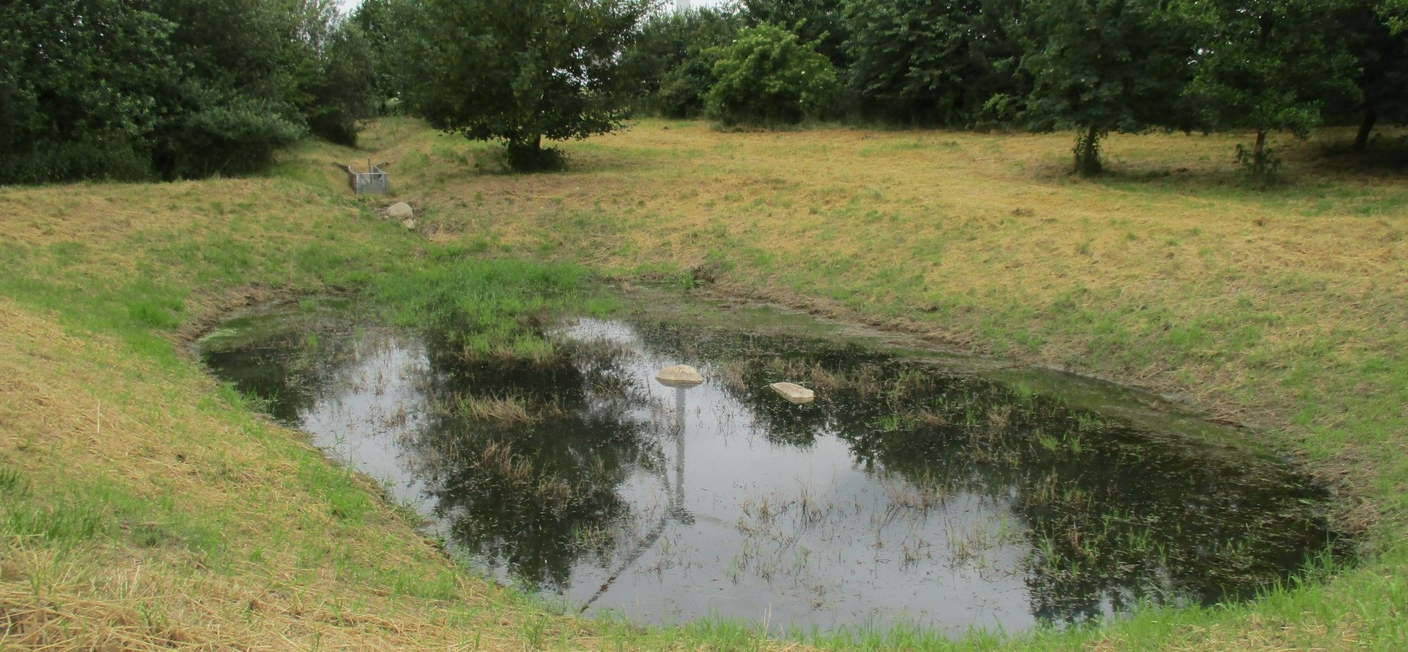
Detention ponds are artificially excavated basins that collect stormwater runoff and eroded sediment from the upstream catchment. The water stored in these ponds is slowly released into a water body or it infiltrates into the groundwater – or both. Their primary functions are flood control, erosion control and water quality improvement.
2.2 ການອະທິບາຍ ລາຍລະອຽດ ຂອງເຕັກໂນໂລຢີ
ການພັນລະນາ:
This documentation focuses on a detention basin constructed to hold surface runoff at the lowest point of an agricultural catchment. A well-designed detention pond is an effective flood control and landscape management measure. It stores surface runoff and releases it through controlled flow, infiltration, or evaporation (or a combination), and reduces nutrient inputs to the adjacent water body by filtering out sediment and nutrients through particle deposition, or nutrient uptake by plants. On average, water treatment in a detention pond can remove about 50-60% of suspended solids, 30-35% of total phosphorus and total nitrogen, and 25-65% of metals. Ponds also provide habitat for terrestrial, riparian and aquatic species. In addition to their ecological impact, they have an aesthetic and cultural value to society, for example, as a demonstration of effective sustainable water management.
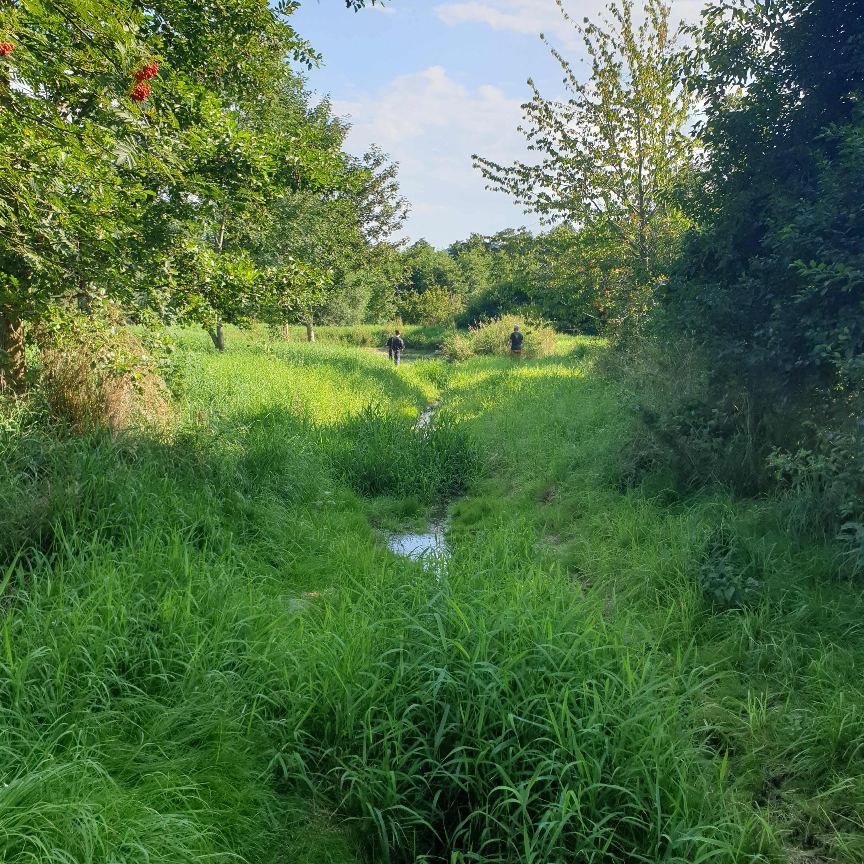
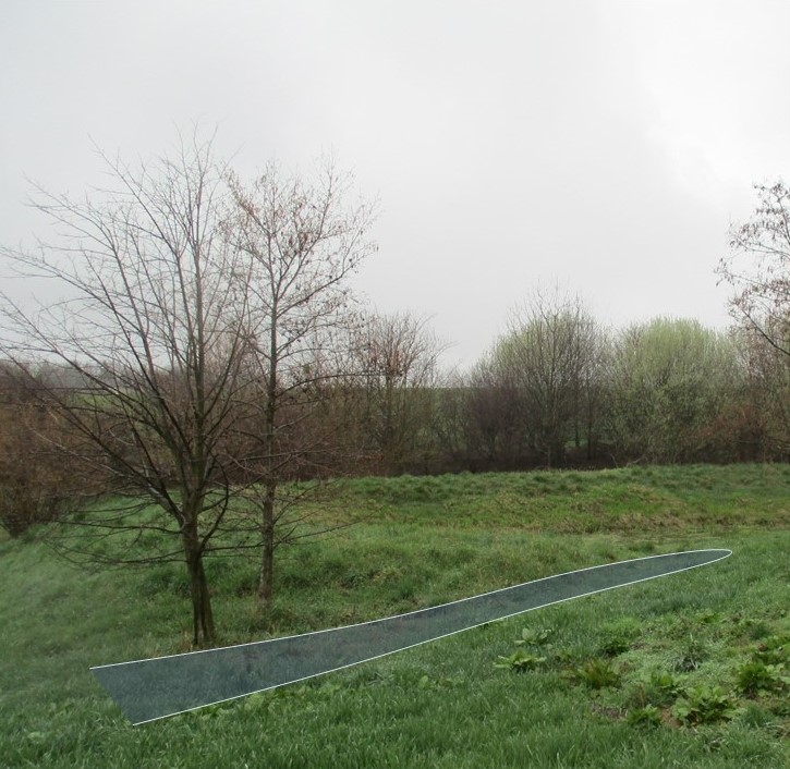
The detention basin described here was constructed by excavating a new depression and ditch system. It consists of a 450 m long inlet channel, a 250 m² pond, and an overflow channel that diverts excess water downstream to the nearest river (Schwarzer Schöps). However, there are no outlet structures for draining water that is captured in the pond (apart from the overflow). All the collected water seeps into the ground and soil particles settle. As a general rule, the size of such a pond should be 3-7% of the upstream catchment and should be able to hold at least the precipitation of a 1 in 30 year rainfall event. However, as the infiltration of the collected water is rather slow, the efficiency is reduced for successive events and overflowing is common. The depth should be between 1.2 m and 2.0 m. A deeper pond can lead to stratification and anoxic conditions, while a shallower pond may cause algal blooms and high biological activity in the summer. Water stored in the pond should remain for at least 20 days to ensure biological treatment.
The construction of the detention pond in this documentation was initiated as a compensation and replacement measure for the construction of a new road in 2016. Accordingly, the road construction authority, the landscape conservation association and a farmer were involved in the implementation.
As usual with such measures there are drawbacks as well as positive impact for landowners. The measure consumes a lot of land, which automatically results in yield losses. It is expensive to build and not easy to construct - and requires the help of an engineering firm while also being time-consuming to maintain. Maintenance is required to sustain the benefits of the technology. For a pond such as that documented here, the following maintenance activities are necessary: during the first three years, maintenance includes mowing the surrounding green area and the dried out pond and channel three times per year. After the fourth year, maintenance includes (a) an annual function check, (b) a check for pest infestation every two years, and (c) suppression of excess woody growth every eight to ten years. Twice a year (mid-June and late August), the grass around the pond and in the intake channel is mowed and the clippings are removed. Shrubs and woody plants are maintained, especially by pruning woody plants (every 8 to 10 years) and coppicing sections of shrubs (every 10 to 15 years). In the long term, it may be necessary to remove the deposited sediments in order to maintain the retention capacity.
2.3 ຮູບພາບຂອງເຕັກໂນໂລຢີ
ສື່ຮູບພາບ
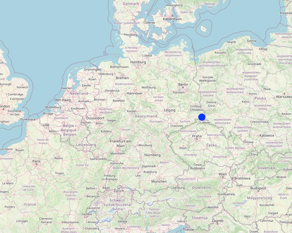
2.5 ປະເທດ / ເຂດ / ສະຖານທີ່ບ່ອນທີ່ ເຕັກໂນໂລຢີ ໄດ້ຮັບການນໍາໃຊ້ ແລະ ທີ່ຖືກປົກຄຸມດ້ວຍການປະເມີນຜົນ
ປະເທດ:
ເຢຍລະມັນ
ພາກພື້ນ / ລັດ / ແຂວງ:
Saxony
ຂໍ້ມູນເພີ່ມເຕີມຂອງສະຖານທີ່:
Reichenbach
ໃຫ້ລະບຸ ການແຜ່ຂະຫຍາຍ ເຕັກໂນໂລຢີ:
- ນໍາໃຊ້ໃນຈຸດສະເພາະ / ແນໃສ່ນໍາໃຊ້ໃນພື້ນທີ່ຂະໜາດນ້ອຍ
ສ່ວນຫຼາຍສະຖານທີ່ຕັ້ງຂອງເຕັກໂນໂລຢີ ແມ່ນ ຢູ່ໃນເຂດພື້ນທີ່ສະຫງວນບໍ?
ບໍ່ແມ່ນ
Map
×2.6 ວັນທີໃນການຈັດຕັ້ງປະຕິບັດ
ຖ້າຫາກວ່າ ບໍ່ຮູ້ຈັກ ປີທີ່ຊັດເຈນ ແມ່ນໃຫ້ປະມານ ວັນທີເອົາ:
- 10-50 ປີ ຜ່ານມາ
2.7 ການນໍາສະເໜີ ເຕັກໂນໂລຢີ
- Compensation measure
ຄວາມຄິດເຫັນ (ປະເພດ ໂຄງການ ແລະ ອື່ນໆ):
The construction of the detention pond was initiated as a compensation measure for the construction for the road construction project "S70 OU Reichenbach 2. BA".
3. ການໃຈ້ແຍກ ເຕັກໂນໂລຢີ ໃນການຄຸ້ມຄອງ ດິນແບບຍືນຍົງ
3.1 ຈຸດປະສົງຫຼັກ (ຫຼາຍ) ຂອງເຕັກໂນໂລຢີ
- ຫຼຸດຜ່ອນ, ປ້ອງກັນ, ຟື້ນຟູ ການເຊື່ອມໂຊມຂອງດິນ
- ການອະນຸລັກ ລະບົບນິເວດ
- ປົກປັກຮັກສານໍ້າ / ນໍ້າພື້ນທີ່ - ປະສົມປະສານກັບ ເຕັກໂນໂລຢີອື່ນໆ
- ຫຼຸດຜ່ອນຄວາມສ່ຽງ ທາງໄພພິບັດທໍາມະຊາດ
- ສ້າງຜົນກະທົບ ທີ່ເປັນທາງບວກ ໃຫ້ແກ່ສັງຄົມ
3.2 ປະເພດການນໍາໃຊ້ທີ່ດິນ ໃນປະຈຸບັນ() ທີ່ເຕັກໂນໂລຢີ ໄດ້ຖືກນໍາໃຊ້
ການນຳໃຊ້ທີ່ດິນ ປະສົມພາຍໃນພື້ນທີ່ດຽວກັນ:
ບໍ່ແມ່ນ

ອື່ນໆ
ລະບຸ ຊະນິດ:
extensively farmed grassland
3.3 ການນຳໃຊ້ທີ່ດິນ ມີການປ່ຽນແປງຍ້ອນການຈັດຕັ້ງທົດລອງເຕັກໂນໂລຢີ ແມ່ນບໍ່?
ການນຳໃຊ້ທີ່ດິນ ມີການປ່ຽນແປງຍ້ອນການຈັດຕັ້ງທົດລອງເຕັກໂນໂລຢີ ແມ່ນບໍ່?
- ບໍ່ (ຕໍ່ເໜືອງກັບ ຄຳຖາມ 3.4)
3.4 ການສະໜອງນ້ຳ
ການສະໜອງນໍ້າ ໃນພື້ນທີ່ ທີ່ໄດ້ນໍາໃຊ້ ເຕັກໂນໂລຢີ:
- ນໍ້າຝົນ
3.5 ການນໍາໃຊ້ເຕັກໂນໂລຢີ ທີ່ຢູ່ໃນກຸ່ມການຄຸ້ມຄອງ ທີ່ດິນແບບຍືນຍົງ
- ການເກັບກັກນໍ້າ
- ຫຼຸດຜ່ອນຄວາມສ່ຽງ ທາງໄພພິບັດ ບົນພື້ນຖານລະບົບນິເວດ
3.6 ມາດຕະການ ການຄຸ້ມຄອງ ທີ່ດິນແບບຍືນຍົງ ປະກອບດ້ວຍ ເຕັກໂນໂລຢີ

ມາດຕະການໂຄງສ້າງ
- S5: ເຂື່ອນໄຟຟ້າ, ຝາຍເກັບນໍ້າ, ອ່າງ, ໜອງ
3.7 ປະເພດດິນເຊື່ອມໂຊມ ຫຼັກທີ່ໄດ້ນໍາໃຊ້ ເຕັກໂນໂລຢີ

ດິນເຊາະເຈື່ອນ ໂດຍນໍ້າ
- Wt: ການສູນເສຍຊັ້ນໜ້າດິນ / ການເຊາະເຈື່ອນຜິວໜ້າດິນ
- Wg: ການເຊາະເຈື່ອນຮ່ອງນ້ຳ / ຫ້ວຍ

ການເຊື່ອມໂຊມ ຂອງນໍ້າ
- Hs: ການປ່ຽນແປງ ປະລິມານ ນໍ້າໜ້າດິນ
- Hg: ການປ່ຽນແປງ ລະດັບນ້ຳໃຕ້ດິນ ຫຼື ນ້ຳບາດານ
3.8 ການປ້ອງກັນ, ການຫຼຸດຜ່ອນ, ຫຼືການຟື້ນຟູຂອງການເຊື່ອມໂຊມຂອງດິນ
ໃຫ້ລະບຸ ເປົ້າໝາຍ ເຕັກໂນໂລຢີ ທີ່ພົວພັນ ກັບຄວາມເຊື່ອມໂຊມຂອງດິນ:
- ຫຼຸດຜ່ອນການເຊື່ອມໂຊມຂອງດິນ
- ການຟື້ນຟູ / ຟື້ນຟູດິນທີ່ຊຸດໂຊມ
4. ຂໍ້ກໍາໜົດ, ກິດຈະກໍາການປະຕິບັດ, ວັດຖຸດິບ, ແລະຄ່າໃຊ້ຈ່າຍ
4.1 ເຕັກນິກ ໃນການແຕ້ມແຜນວາດ ເຕັກໂນໂລຢີ

ຄຸນລັກສະນະ ຂອງເຕັກນິກ (ທີ່ກ່ຽວຂ້ອງ ກັບການແຕ້ມແຜນວາດ ທາງດ້ານເຕັກນີກ):
Securing dam stability by willow sticks.
ຜູ້ຂຽນ:
LISt Gesellschaft für Verkehrswesen und ingenieurtechnische Dienstleistungen mbH, Bereich Kompensationsmaßnahmenmanagement
ວັນທີ:
29/02/2016

ຄຸນລັກສະນະ ຂອງເຕັກນິກ (ທີ່ກ່ຽວຂ້ອງ ກັບການແຕ້ມແຜນວາດ ທາງດ້ານເຕັກນີກ):
A detention pond (in genreral) consists of a sediment forebay (pretreatment system), a permanent pool that is intended to remain wet throughout the year (but may dry out), a temporary storage pond for flood attenuation, and a shallow zone or aquatic bench along the edge of the permanent pool to support wetland planting that provides ecological and safety benefits. It should be wedge-shaped with a length to width ratio of between 3:1 and 5:1. The side slope shouldn’t be steeper than 1:3 for public safety and maintenance access.
ຜູ້ຂຽນ:
Hunt et al. (2020)
ວັນທີ:
20/02/2020
4.2 ຂໍ້ມູນທົ່ວໄປກ່ຽວກັບການຄິດໄລ່ປັດໃຈຂາເຂົ້າໃນການຜະລິດ ແລະ ມູນຄ່າອື່ນໆ
ລະບຸ ວິທີການ ຄຳໃຊ້ຈ່າຍ ແລະ ປັດໄຈນໍາເຂົ້າ ທີ່ໄດ້ຄິດໄລ່:
- ຕໍ່ຫົວໜ່ວຍ ທີ່ໄດ້ຈັດຕັ້ງປະຕິບັດ ເຕັກໂນໂລຢີ
ໃຫ້ລະບຸຫົວໜ່ວຍ:
Detention pond (as documented here)
ກໍານົດຂະຫນາດຂອງຫົວນ໋ວຍ (ຖ້າກ່ຽວຂ້ອງ):
225 m², ca. 337,5 m³ (water depth of 1,5m)
ສະກຸນເງິນອື່ນໆ / ປະເທດອື່ນໆ (ລະບຸ):
€
ຖ້າກ່ຽວຂ້ອງ, ໃຫ້ລະບຸອັດຕາແລກປ່ຽນຈາກ USD ເປັນສະກຸນເງິນທ້ອງຖິ່ນ (ເຊັ່ນ: 1 USD = 79.9 Brazilian Real): 1 USD =:
0.91
ລະບຸ ຄ່າຈ້າງ ຄ່າແຮງງານສະເລ່ຍ ຕໍ່ ວັນ:
18.70 € per hour
4.3 ການສ້າງຕັ້ງກິດຈະກໍາ
| ກິດຈະກໍາ | Timing (season) | |
|---|---|---|
| 1. | remove topsoil | |
| 2. | profile water body according to site plan (Standing water 1.5 m deep, ditch 0.5-1.5m deep) | |
| 3. | installing of inlet channel | |
| 4. | installing erosion protection on embankments | |
| 5. | cover the topsoil / terrain profiling | |
| 6. | planting of shrubs & aquatic plants along the shoreline | |
| 7. | ditch connection to Schwarzer-Schöps | |
| 8. | reprofiling ditches (90m) | |
| 9. | desilting of drainage ditch to Schwarzer-Schöps | |
| 10. | subsequent installation of a spillway (beak structure: 'Schnabelbauwerk') and willow sticks as an erosion control measure for the ditch connection to Schwarzer-Schöps. |
4.4 ຕົ້ນທຶນ ແລະ ປັດໄຈຂາເຂົ້າທີ່ຈໍາເປັນໃນຈັດຕັ້ງປະຕິບັດ
ຖ້າທ່ານບໍ່ສາມາດ ໄຈ້ແຍກຄ່າໃຊ້ຈ່າຍໃນຕາຕະລາງຂ້າງເທິງ, ໃຫ້ຄາດຄະເນຂອງຄ່າໃຊ້ຈ່າຍທັງຫມົດ ຂອງການສ້າງເຕັກໂນໂລຢີ:
25250.0
ຖ້າຫາກຜູ້ນຳໃຊ້ທີ່ດິນ ນຳໃຊ້ມູນຄ່າຕ່ຳກວ່າ 100% ໃຫ້ລະບຸ ແມ່ນໃຜເປັນຜູ້ຊ່ວຍ ໃນລາຍຈ່າຍທີ່ເຫຼືອ:
The costs were covered by the road construction authority (compensation measure for the construction of a new road)
ຄວາມຄິດເຫັນ:
based on estimated average costs (nwrm.eu)
4.5 ບໍາລຸງຮັກສາ / ແຜນຈັດຕັ້ງປະຕິບັດ ກິດຈະກໍາ
| ກິດຈະກໍາ | ໄລຍະເວລາ / ຄວາມຖີ່ | |
|---|---|---|
| 1. | completion and development maintenance (mowing of the green area and the water-free water body) | first three years: three times per year |
| 2. | functional check | after the fourth year: every year |
| 3. | check for pest infestation | after the fourth year : every other year |
| 4. | check to suppress unwanted woody growth | after the fourth year: every 8 to 10 years |
| 5. | grass around the pond and in the intake channel is mowed and the clippings are removed | after the fourth year: twice a year (mid-June and late August) |
| 6. | pruning woody plants | every 8 to 10 years |
| 7. | putting sections of shrubs on stock | every 10 to 15 years |
4.6 ຄ່າໃຊ້ຈ່າຍ ແລະ ປັດໄຈນໍາເຂົ້າທີ່ຈໍາເປັນສໍາລັບການບໍາລຸງຮັກສາກິດຈະກໍາ / ແຜນປະຕິບັດ (ຕໍ່ປີ)
ຖ້າທ່ານບໍ່ສາມາດ ໄຈ້ແຍກຄ່າໃຊ້ຈ່າຍໃນຕາຕະລາງຂ້າງເທິງ, ໃຫ້ຄາດຄະເນຂອງຄ່າໃຊ້ຈ່າຍທັງຫມົດ ຂອງການບຳລຸງຮັກສາ ເຕັກໂນໂລຢີ:
618.0
ຖ້າຫາກຜູ້ນຳໃຊ້ທີ່ດິນ ນຳໃຊ້ມູນຄ່າຕ່ຳກວ່າ 100% ໃຫ້ລະບຸ ແມ່ນໃຜເປັນຜູ້ຊ່ວຍ ໃນລາຍຈ່າຍທີ່ເຫຼືອ:
The costs are covered by the road construction authority (compensation measure for the construction of a new road)
ຄວາມຄິດເຫັນ:
estimated average costs (nwrm.eu)
4.7 ປັດໄຈ ທີ່ສໍາຄັນ ທີ່ສົ່ງຜົນກະທົບ ຕໍ່ຄ່າໃຊ້ຈ່າຍ
ໃຫ້ອະທິບາຍ ປັດໃຈ ທີ່ສົ່ງຜົນກະທົບ ຕໍ່ຕົ້ນທຶນ ໃນການຈັດຕັ້ງປະຕິບັດ:
From the government perspective: A budget must be set aside annually for necessary maintenance to ensure functional efficiency.
5. ສະພາບແວດລ້ອມທໍາມະຊາດ ແລະ ມະນຸດ
5.1 ອາກາດ
ປະລິມານນໍ້າຝົນປະຈໍາປີ
- < 250 ມີລິແມັດ
- 251-500 ມີລິແມັດ
- 501-750 ມີລິແມັດ
- 751-1,000 ມີລິແມັດ
- 1,001-1,500 ມີລິແມັດ
- 1,501-2,000 ມີລິແມັດ
- 2,001-3,000 ມີລິແມັດ
- 3,001-4,000 ມີລິແມັດ
- > 4,000 ມີລິແມັດ
ຂໍ້ມູນສະເພາະ / ຄວາມເຫັນກ່ຽວກັບ ປະລິມານນໍ້າຝົນ:
Average annual rainfall in mm: 750.82 mm/a
Name of the meteorological station: https://whh-kliwes.de/mapview
ເຂດສະພາບອາກາດກະສິກໍາ
- ເຄີ່ງຄວາມຊຸ່ມ
Length of growing period (LGP): 209 days
(https://www.umwelt.sachsen.de/dauer-der-vegetationsperiode-30631.html)
5.2 ພູມິປະເທດ
ຄ່າສະເລ່ຍ ຄວາມຄ້ອຍຊັນ:
- ພື້ນທີ່ຮາບພຽງ (0-2%)
- ອ່ອນ (3-5 %)
- ປານກາງ (6-10 %)
- ມ້ວນ (11-15 %)
- ເນີນ(16-30%)
- ໍຊັນ (31-60%)
- ຊັນຫຼາຍ (>60%)
ຮູບແບບຂອງດິນ:
- ພູພຽງ / ທົ່ງພຽງ
- ສັນພູ
- ເປີ້ນພູ
- ເນີນພູ
- ຕີນພູ
- ຮ່ອມພູ
ເຂດລະດັບສູງ:
- 0-100 ແມັດ a.s.l.
- 101-500 ແມັດ a.s.l.
- 501-1,000 ແມັດ a.s.l.
- 1,001-1,500 ແມັດ a.s.l.
- 1,501-2,000 ແມັດ a.s.l.
- 2,001-2,500 ແມັດ a.s.l.
- 2,501-3,000 ແມັດ a.s.l.
- 3,001-4,000 ແມັດ a.s.l.
- > 4,000 ແມັດ a.s.l.
ໃຫ້ລະບຸ ເຕັກໂນໂລຢີ ທີ່ໄດ້ຖືກນຳໃຊ້:
- ລັກສະນະກີ່ວ
5.3 ດິນ
ຄວາມເລິກ ຂອງດິນສະເລ່ຍ:
- ຕື້ນຫຼາຍ (0-20 ຊັງຕີແມັດ)
- ຕື້ນ (21-50 ຊຕມ)
- ເລີກປານກາງ (51-80 ຊຕມ)
- ເລິກ (81-120 ຊມ)
- ເລິກຫຼາຍ (> 120 cm)
ເນື້ອດິນ (ໜ້າດິນ):
- ຫຍາບ / ເບົາ (ດິນຊາຍ)
- ປານກາງ (ດິນໜຽວ, ດິນໂຄນ)
ເນື້ອດິນ (ເລິກຈາກໜ້າດິນ ລົງໄປຫຼາຍກວ່າ 20 ຊັງຕິແມັດ):
- ປານກາງ (ດິນໜຽວ, ດິນໂຄນ)
ຊັ້ນອິນຊີວັດຖຸ ເທິງໜ້າດິນ:
- ສູງ (> 3 %)
ຖ້າເປັນໄປໄດ້ ແມ່ນໃຫ້ຕິດຄັດ ການພັນລະນາດິນ ຫຼື ຂໍ້ມູນສະເພາະຂອງດິນ, ຕົວຢ່າງ, ຄຸນລັກສະນະ ປະເພດຂອງດິນ, ຄ່າຄວາມເປັນກົດ / ເປັນດ່າງຂອງດິນ, ສານອາຫານ, ດິນເຄັມ ແລະ ອື່ນໆ.
Luvisol (German soil classification system: Parabraunerde)
5.4 ມີນໍ້າ ແລະ ຄຸນນະພາບ
ລະດັບ ນໍ້າໃຕ້ດິນ:
< 5 ແມັດ
ການມີນໍ້າ ເທິງໜ້າດິນ:
ທຸກຍາກ / ບໍ່ມີ
ຄຸນນະພາບນໍ້າ (ບໍ່ມີການບໍາບັດ):
ບໍ່ມີນໍ້າດື່ມ (ຮຽກຮ້ອງໃຫ້ມີການບຳບັດນ້ຳ)
ຄຸນນະພາບນ້ຳ ໝາຍເຖີງ:
ນ້ຳໜ້າດິນ
ມີບັນຫາ ກ່ຽວກັບນໍ້າເຄັມບໍ່?
ບໍ່ແມ່ນ
ເກີດມີນໍ້າຖ້ວມ ໃນພື້ນທີ່ບໍ່?
ບໍ່ແມ່ນ
5.5 ຊີວະນາໆພັນ
ຄວາມຫຼາກຫຼາຍ ທາງສາຍພັນ:
- ປານກາງ
ຄວາມຫຼາກຫຼາຍ ທາງດ້ານ ທີ່ຢູ່ອາໃສ ຂອງສິ່ງທີ່ມີຊີວິດ:
- ສູງ
5.6 ຄຸນລັກສະນະ ຂອງຜູ້ນໍາໃຊ້ທີ່ດິນ ທີ່ໄດ້ນໍາໃຊ້ເຕັກໂນໂລຢີ
ຢູ່ປະຈຳ ຫຼື ເຄື່ອນຍ້າຍຕະຫຼອດ:
- ບໍ່ເຄື່ອນໄຫວ
ລາຍຮັບ ທີ່ບໍ່ໄດ້ມາຈາກ ການຜະລິດ ກະສິກໍາ:
- ໜ້ອຍກ່ວາ 10 % ຂອງລາຍຮັບທັງໝົດ
ລະດັບຄວາມຮັ່ງມີ:
- ຮັ່ງມີ
ບຸກຄົນ ຫຼື ກຸ່ມ:
- ກຸ່ມ / ຊຸມຊົນ
- ການຈ້າງງານ (ບໍລິສັດ, ອົງການ ລັດຖະບານ)
ລະດັບ ການຫັນເປັນກົນຈັກ:
- ເຄື່ອງກົນຈັກ
ເພດ:
- ຜູ້ຍິງ
- ຜູ້ຊາຍ
ອາຍຸ ຂອງຜູ້ນໍາໃຊ້ທີ່ດິນ:
- ໄວກາງຄົນ
5.7 ເນື້ອທີ່ສະເລ່ຍຂອງດິນ ທີ່ຜູ້ນຳໃຊ້ທີ່ດິນ ໃຊ້ເຮັດເຕັກໂນໂລຢີ
- <0.5 ເຮັກຕາ
- 0.5-1 ເຮັກຕາ
- 1-2 ເຮັກຕາ
- 2-5 ເຮັກຕາ
- 5-15 ເຮັກຕາ
- 15-50 ເຮັກຕາ
- 50-100 ເຮັກຕາ
- 100-500 ເຮັກຕາ
- 500-1,000 ເຮັກຕາ
- 1,000-10,000 ເຮັກຕາ
- > 10,000 ເຮັກຕາ
ຄວາມຄິດເຫັນ:
The technology was not built and is not maintained by a land user, but by a public authority (road construction authority).
5.8 ເຈົ້າຂອງທີ່ດິນ, ສິດໃຊ້ທີ່ດິນ, ແລະ ສິດທິການນໍາໃຊ້ນໍ້າ
ເຈົ້າຂອງດິນ:
- ລັດ
ສິດທິ ໃນການນໍາໃຊ້ທີ່ດິນ:
- ບຸກຄົນ
ສິດທິ ໃນການນໍາໃຊ້ນໍ້າ:
- ຊຸມຊົນ (ທີ່ມີການຈັດຕັ້ງ)
ສິດນຳໃຊ້ທີ່ດິນ ແມ່ນ ອີງໃສ່ລະບົບກົດໝາຍແບບດັ້ງເດີມບໍ?
ບໍ່ແມ່ນ
5.9 ການເຂົ້າເຖິງການບໍລິການ ແລະ ພື້ນຖານໂຄງລ່າງ
ສຸຂະພາບ:
- ທຸກຍາກ
- ປານກາງ
- ດີ
ການສຶກສາ:
- ທຸກຍາກ
- ປານກາງ
- ດີ
ການຊ່ວຍເຫຼືອ ດ້ານວິຊາການ:
- ທຸກຍາກ
- ປານກາງ
- ດີ
ການຈ້າງງານ (ຕົວຢ່າງ, ການເຮັດກິດຈະກໍາອື່ນ ທີ່ບໍ່ແມ່ນ ການຜະລິດກະສິກໍາ):
- ທຸກຍາກ
- ປານກາງ
- ດີ
ຕະຫຼາດ:
- ທຸກຍາກ
- ປານກາງ
- ດີ
ພະລັງງານ:
- ທຸກຍາກ
- ປານກາງ
- ດີ
ຖະໜົນຫົນທາງ ແລະ ການຂົນສົ່ງ:
- ທຸກຍາກ
- ປານກາງ
- ດີ
ການດື່ມນໍ້າ ແລະ ສຸຂາພິບານ:
- ທຸກຍາກ
- ປານກາງ
- ດີ
ການບໍລິການ ທາງດ້ານການເງິນ:
- ທຸກຍາກ
- ປານກາງ
- ດີ
6. ຜົນກະທົບ ແລະ ລາຍງານສະຫຼຸບ
6.1 ການສະແດງຜົນກະທົບ ພາຍໃນພື້ນທີ່ ທີ່ໄດ້ຈັດຕັ້ງປະຕິບັດ ເຕັກໂນໂລຢີ
ຜົນກະທົບທາງເສດຖະກິດສັງຄົມ
ມີນໍ້າ ແລະ ຄຸນນະພາບ
ມີນໍ້າຊົນລະປະທານ
ລາຍໄດ້ ແລະ ຄ່າໃຊ້ຈ່າຍ
ຄ່າໃຊ້ຈ່າຍ ປັດໄຈນໍາເຂົ້າ ໃນການຜະລິດກະສິກໍາ
ຄວາມຄິດເຫັນ / ລະບຸແຈ້ງ:
not on agricultural inputs, but establishment and maintenance consume a lot of money.
ມີວຽກໜັກ
ຜົນກະທົບຕໍ່ລະບົບນິເວດ
ວົງຈອນນໍ້າ / ນໍ້າ
ຄຸນນະພາບນໍ້າ
ຄວາມຄິດເຫັນ / ລະບຸແຈ້ງ:
Improved water quality of subsequent river Schwarzer-Schöps.
ການລະບາຍນໍ້າ
ດິນ
ຄວາມຊຸ່ມຂອງດິນ
ຄວາມຄິດເຫັນ / ລະບຸແຈ້ງ:
Soil moisture next to the retention pond increased due to infiltration.
ຊີວະນານາພັນ: ສັດ, ພືດ
ຄວາມຫຼາກຫຼາຍຂອງພືດ
ຄວາມຄິດເຫັນ / ລະບຸແຈ້ງ:
More plant diversity compared to normal farmed grassland.
ຄວາມຫຼາກຫຼາຍຂອງສັດ
ຄວາມຫຼາກຫຼາຍ ທາງດ້ານທີ່ຢູ່ອາໃສ ຂອງສິ່ງທີ່ມີຊີວິດ
ການຫຼຸດຜ່ອນ ຄວາມສ່ຽງ ຈາກໄພພິບັດ ແລະ ອາກາດປ່ຽນແປງ
ຜົນກະທົບ ຂອງນໍ້າຖ້ວມ
ລະບຸ ການປະເມີນຜົນກະທົບ ຕໍ່ສະຖານທີ່ (ການວັດແທກ):
The assessment is based on expert judgements. It is not based on on-site measurements.
6.2 ຜົນກະທົບທາງອ້ອມ ຈາກການນໍາໃຊ້ເຕັກໂນໂລຢີ
ສາມາດເຂົ້າເຖິງແຫຼ່ງນໍ້າ
ມົນລະພິດ ທາງນໍ້າ / ນໍ້າໄຕ້ດິນ
ກໍານົດ ການປະເມີນ ຜົນກະທົບທາງນອກ (ການວັດແທກ):
The assessment is based on the expertise of the compilers and not on measurements in the case study.
6.3 ການປ້ອງກັນ ແລະ ຄວາມບອບບາງ ຂອງເຕັກໂນໂລຢິ ໃນການປ່ຽນແປງສະພາບດິນຟ້າອາກາດ ແລະ ກ່ຽວຂ້ອງກັບອາກາດທີ່ມີການປ່ຽນແປງທີ່ຮຸນແຮງ / ໄພພິບັດທາງທໍາມະຊາດ (ຮັບຮູ້ໄດ້ໂດຍຜູ້ນໍາໃຊ້ທີ່ດິນ)
ການປ່ຽນແປງດິນຟ້າອາກາດ ເທື່ອລະກ້າວ
ການປ່ຽນແປງດິນຟ້າອາກາດ ເທື່ອລະກ້າວ
| ລະດູການ | ເພີ່ມຂື້ນ ຫຼື ຫຼຸດລົງ | ການນໍາໃຊ້ ເຕັກໂນໂລຢີ ສາມາດ ຮັບມື ໄດ້ຄືແນວໃດ? | |
|---|---|---|---|
| ປະລິມານນໍ້າຝົນປະຈໍາປີ | ຫຼຸດລົງ | ດີ |
ອາກາດ ທີ່ກ່ຽວພັນກັບຄວາມຮຸນແຮງ (ໄພພິບັດທາງທໍາມະຊາດ)
ໄພພິບັດທາງອຸຕຸນິຍົມ
| ການນໍາໃຊ້ ເຕັກໂນໂລຢີ ສາມາດ ຮັບມື ໄດ້ຄືແນວໃດ? | |
|---|---|
| ພະຍຸຝົນ | ດີຫຼາຍ |
ໄພພິບັດທາງພູມອາກາດ
| ການນໍາໃຊ້ ເຕັກໂນໂລຢີ ສາມາດ ຮັບມື ໄດ້ຄືແນວໃດ? | |
|---|---|
| ຄື້ນຄວາມອົບອຸ່ນ | ດີ |
ຄວາມຄິດເຫັນ:
In past summers there was little or no water left in the pond.
6.4 ການວິເຄາະຕົ້ນທຶນ ແລະ ຜົນປະໂຫຍດ
ຈະເຮັດປະໂຫຍດເພື່ອປຽບທຽບກັບຄ່າໃຊ້ຈ່າຍກັບສິ່ງກໍ່ສ້າງ (ຈາກທັດສະນະຂອງຜູ້ນຳໃຊ້ທີ່ດິນ) ໄດ້ແນວໃດ?
ຜົນຕອບແທນ ໃນໄລຍະສັ້ນ:
ຜົນກະທົບທາງລົບຫຼາຍ
ຜົນຕອບແທນ ໃນໄລຍະຍາວ:
ຜົນກະທົບທາງລົບ
ຈະໄດ້ຮັບຜົນປະໂຫຍດເມື່ອປຽບທຽບກັບ / ຄ່າໃຊ້ຈ່າຍໃນການບຳລຸງຮັກສາທີເ່ກີດຂື້ນອິກ (ຈາກທັດສະນະຄະຕິຂອງຜູ້ນຳໃຊ້ທີ່ດິນ) ໄດ້ແນວໃດ?
ຜົນຕອບແທນ ໃນໄລຍະສັ້ນ:
ຜົນກະທົບທາງລົບເລັກນ້ອຍ
ຜົນຕອບແທນ ໃນໄລຍະຍາວ:
ປານກາງ
6.5 ການປັບຕົວຮັບເອົາເຕັກໂນໂລຢີ
- ກໍລະນີດຽວ / ການທົດລອງ
6.6 ການປັບຕົວ
ໄດ້ມີການດັດປັບ ເຕັກໂນໂລຢີ ເພື່ອໃຫ້ແທດເໝາະກັບເງື່ອນໄຂ ການປ່ຽນແປງບໍ?
ບໍ່ແມ່ນ
6.7 ຈຸດແຂງ / ຂໍ້ດີ / ໂອກາດ ໃນການນໍາໃຊ້ ເຕັກໂນໂລຢີ
| ຈຸດແຂງ / ຂໍ້ດີ / ໂອກາດໃນການນໍາໃຊ້ທີ່ດິນ |
|---|
| temporary water-bearing habitat |
| biotopic network |
| buffer effect |
| ຈຸດແຂງ / ຈຸດດີ / ໂອກາດ ຈາກທັດສະນະຂອງຜູ້ປ້ອນຂໍ້ມູນ ຫຼື ບຸກຄົນສຳຄັນ |
|---|
| effective flood control and landscape management measure |
| Stores surface runoff, slows it down, and releases it incrementally through controlled runoff, infiltration, or evaporation. Reduces nutrient inputs to adjacent water bodies. |
| aesthetic and cultural value for the society |
6.8 ຈຸດອ່ອນ / ຂໍ້ເສຍ / ຄວາມສ່ຽງ ໃນການນໍາໃຊ້ ເຕັກໂນໂລຢີ ແລະ ວິທີການແກ້ໄຂບັນຫາ
| ຈຸດອ່ອນ / ຂໍ້ເສຍ / ຄວາມສ່ຽງໃນມຸມມອງຂອງຜູ້ນໍາໃຊ້ທີ່ດິນ | ມີວິທີການແກ້ໄຂຄືແນວໃດ? |
|---|---|
| Danger of siltation and succession if not maintained regularly and professionally. | |
| Difficult maintenance due to inaccessible terrain. |
| ຈຸດອ່ອນ/ຂໍ້ບົກຜ່ອງ/ຄວາມສ່ຽງ ຈາກທັດສະນະຂອງຜູ້ປ້ອນຂໍ້ມູນ ຫຼື ບຸກຄົນສຳຄັນ | ມີວິທີການແກ້ໄຂຄືແນວໃດ? |
|---|---|
| Consumes a lot of land, which means a loss of yield. | |
| expensive to build and not easy to construct | |
| requires the help of an engineering firm | |
| time-consuming to maintain |
7. ເອກະສານອ້າງອີງ ແລະ ການເຊື່ອມຕໍ່
7.1 ວິທີການ / ແຫຼ່ງຂໍ້ມູນ
- ການໄປຢ້ຽມຢາມພາກສະໜາມ, ການສໍາຫຼວດພາກສະໜາມ
1
- ການສໍາພາດ ຜູ້ນໍາໃຊ້ທີ່ດິນ
1
ເມື່ອໃດທີ່ໄດ້ສັງລວມຂໍ້ມູນ (ຢູ່ພາກສະໜາມ)?
14/09/2021
7.3 ເຊື່ອມຕໍ່ກັບຂໍ້ມູນທີ່ກ່ຽວຂ້ອງໂດຍກົງ
ຫົວຂໍ້ / ພັນລະນາ:
Hunt et al. (2020): Plant Selection for Infiltrating Wet Ponds in North Carolina
URL:
https://content.ces.ncsu.edu/plant-selection-for-infiltrating-wet-ponds-in-north-carolina
ຫົວຂໍ້ / ພັນລະນາ:
nwrm.eu: Individual NWRM, retention pond
URL:
http://nwrm.eu/index.php/measure/retention-ponds
ຂໍ້ມູນການເຊື່ອມຕໍ່ ແລະ ເນື້ອໃນ
ຂະຫຍາຍທັງໝົດ ຍຸບທັງໝົດການເຊື່ອມຕໍ່
ບໍ່ມີຂໍ້ມູນການເຊື່ອມຕໍ່
ເນື້ອໃນ
ບໍ່ມີເນື້ອໃນ